Wyoming State Water Plan
Wyoming State Water Plan
Wyoming Water Development Office
6920 Yellowtail Rd
Cheyenne, WY 82002
Phone: 307-777-7626

Wyoming Water Development Office
6920 Yellowtail Rd
Cheyenne, WY 82002
Phone: 307-777-7626


| SUBJECT: |
Appendix F Water Right Permits GIS Data |
| PREPARED BY: |
Erin Wilson and Heather Justus, Leonard Rice Consulting Water Engineer, Inc. |
INTRODUCTION
This memorandum discusses the development of the water right permits coverages for the Wyoming Water Development Commission’s Bear River Basin Project. Task objectives were to:
The coverages described in this memorandum are developed to assist in the estimation of overall consumptive use and general use location in the Bear River Basin, Wyoming.
APPROACH
To accomplish these objectives, irrigated lands were mapped, permit data were collected, and GIS coverages were constructed.
Irrigated Lands
States West Water Resources Corporation developed an irrigated lands GIS coverage for the Bear River Basin, Wyoming. Leonard Rice Consulting Water Engineers, Inc added a field to the GIS coverage called Irr_ID. This field enables the user to link the associated permit coverages to the irrigated lands.
For more information on the irrigated lands GIS coverage, please refer to Technical Memorandum titled “Bear River Basin Plan, Irrigated Lands GIS Data”, O'Grady, M.; Carr, F.; and Meena, J; July14, 2000.
Water Rights Database Development
Upon completion of irrigated lands mapping, Mr. Frank Carr assigned water rights attributes to each identified irrigated polygon. To assist the reader, Mr. Carr has provided a brief description of water rights terminology specific to Wyoming’s water law policy and procedure in Appendix A of the ”Irrigated Lands GIS Data” memo.
The water rights permitted to serve some or all of the land within each individual irrigated polygon in the irrigated lands theme were extracted from the original records on file at the Wyoming State Engineer’s Office and State Board of Control located in Cheyenne, Wyoming. Note that this is not intended to represent all water rights in the basin, only water rights associated with acreage defined as irrigated in 1998. The water right database fields include the irrigated parcel identifier, permit number, source, ditch or well name, priority date, amount of appropriation (cfs or gpm), number of acres, type of supply (original, additional, supplemental, secondary), and status (adjudicated, unadjudicated, expired, and canceled).
Water Right Permits Coverage
An ArcView point coverage was developed that represents the surface, well, and reservoir water permits in the water rights database as a point in the respective irrigated polygon, general well location, or reservoir location. Most of the irrigated polygons have several associated permits. In addition, many of the permits are assoicated with more than one irrigated polygon. This relationship is termed "many-to-many". The water right permits coverage is a stand-alone theme that can be linked through the Irr_id, and the Source & Facility (Source_f) fields. The Irr_id field links the coverage to the irrigated lands coverage. When linked, an ArcView query of a particular water right will identify irrigated polygons served by that water right. Also, a query of a particular irrigated polygon will identify water rights associated with the acreage. The Source & Facility (Source_f) links the coverage to the point of diversion coverage as discussed below.
In addition to the values as shown on the actual permits, the water right permits coverage also contains link fields for programmer use. The water right permits coverage attribute table includes the following fields:
Points of Diversion Coverage
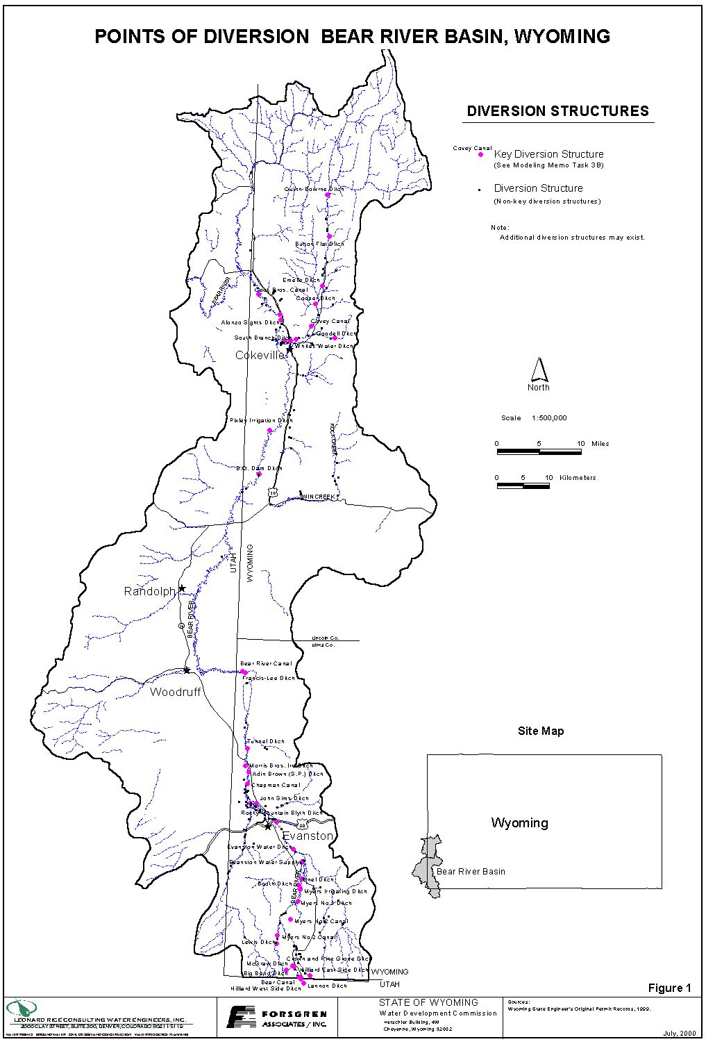
In order to determine actual locations where permits divert from their source, the points of diversion for the permits in the water rights database were mapped and used to create a GIS coverage. This coverage contains one point for each diversion headgate. To obtain the permit data associated with the points of diversion, the water right permits coverage and the points of diversion coverage are linked with the Source & Facility field (Source_f). An Arcview query of the interested Source & Facility in the water right permits coverage table will obtain all permit data associated with a point of diversion. The final coverage, shown in Figure 1, contains the following fields:
Water Well Permit Coverage
An ArcView point coverage was developed that represents well permits in the water rights database. The location of wells was estimated from the quarter-quarter description on the permit unless more precise location information was available. Ground water wells permitted for irrigation that have a capacity over 50 gpm are included in the database. Wells permitted for miscellaneous, industrial, or municipal use were also included. The 50 gpm cutoff for irrigation wells essentially excluded domestic use wells. Table 1 summarizes the well permits information for the basin.
| TABLE 1: Wells in Well Permit Coverage | ||
| Permitted Use | Number of Wells | Total Permitted Rate (gpm) |
| Miscellaneous | 22 | 1,870 |
| Commercial | 2 | 240 |
| Domestic | 1 | 130 |
| Industrial | 4 | 661 |
| Industrial-Domestic | 1 | 60 |
| Industrial - Miscellaneous | 2 | 304 |
| Irrigation | 44 | 37,984 |
| Irrigation -Stock-Domestic | 1 | 500 |
| Municipal | 6 | 3,250 |
| Stock - Domestic - Irrigation | 3 | 300 |
| Stock - Irrigation | 1 | 200 |
| Sources: Wyoming State Engineer’s Office, Original water rights records for surface and ground water permits. | ||
The database fields include the permit information described above in the water rights permit coverage. The well permit coverage can be linked through the Irr_id field so that ArcView queries between irrigated polygons and wells can be easily made.
Reservoir Permit Coverage
An ArcView point coverage was developed to depict the reservoir permitted rights in the water right database. The coverage depicts the reservoir permits as points in the general location of each reservoir. The database fields include the permit information as stated above in the water rights permit coverage. Table 2 list the reservoir water right permits in the Bear River Basin, Wyoming
| TABLE 2 RESERVOIR WATER RIGHT PERMITS | ||||||
| Permit # | Source | Facility Name | Priority | Amount AF |
Status | USE |
| 5513 Res. | Gooseberry Creek | Thoman Reservoir | 19430316 | 98.08 | adj. | irr-stk |
| 6556 Res. (W) | Bear River | Woodruff Narrows Res. | 19590803 | 28,100.00 | adj. | irr-ind-fish |
| 6556 Res. (U) | Bear River | Woodruff Narrows Res | 19590803 | 0.00 | adj. | n/a |
| 8060 Res. | Bear River | Woodruff Narrows Res | 19750725 | 24,677.00 | adj. | irr. |
| 8061 Res. | Bear River | Woodruff Narrows Res | 19790806 | 4,523.00 | adj. | irr. |
| 5695 Res. | Sulphur Creek | Sulphur Creek Reservoir | 19500214 | 1,404.13 | adj. | irr |
| 6481 Res. | Sulphur Creek | Sulphur Creek Reservoir | 19580812 | 510.41 | adj. | irr |
| 6562 Res. | Sulphur Creek | Sulphur Creek Reservoir | 19581001 | 1,528.85 | adj. | irr |
| 9222 Res. | Sulphur Creek | Sulphur Creek Reservoir | 19820808 | 13,631.00 | adj. | irr-mun-fish |
| 6884 Res. | Mill Creek | Massea Reservoir | 19600119 | 107.50 | adj. | irr-s-d |
| 6434 Res. | Bazoo Hallow | Martin Reservoir | 19580529 | 87.90 | adj. | irr |
| 896 Res. | Willow Creek | Heber Reservoir | 19060821 | 388.50 | adj. | irr-dom |
| 4057 Res. | Pleasant Valley Creek | Crompton Reservoir | 19280120 | 90.83 | adj. | irr-s-d |
| 4616 Res. | Pleasant Valley Creek | Crompton Reservoir | 19341113 | 74.96 | adj. | irr-s-d |
| 5515 Res. | Pleasant Valley Creek | Painter Reservoir | 19431207 | 167.61 | adj. | irr |
| 6117 Res. | Pleasant Valley Creek | Crompton Reservoir | 19540205 | 406.25 | adj. | irr |
| 5270 Res. | Pleasant Valley Creek | Crompton Reservoir | 19400425 | 208.68 | adj. | irr |
| 5064 Res. | Mill Creek | Myers Reservoir | 19390328 | 556.50 | adj. | irr |
| 10278 Res. | Van Tassel Creek | Ben Reservoir | 19950407 | 300.29 | un-adj | irr |
| 10657 Res. | Van Tassel Creek | Ben Reservoir | 19971208 | 2.86 | un-adj | irr |
| Sources: Wyoming State Engineer’s Office, Original water rights records for surface and ground water permits. | ||||||
| Key to Abbreviated Words in TABLE 2 | |||
| Abbreviation | Word | Abbreviation | Word |
| Res. | reservoir | stk | stock |
| (W) | Wyoming | ind | industrial |
| (U) | Utah | n/a | not applicable |
| Adj. | adjudicated | mun | municipal |
| Un-adj. | un-adjudicated | d | domestic |
| irr | irrigated | s | stock |
Results
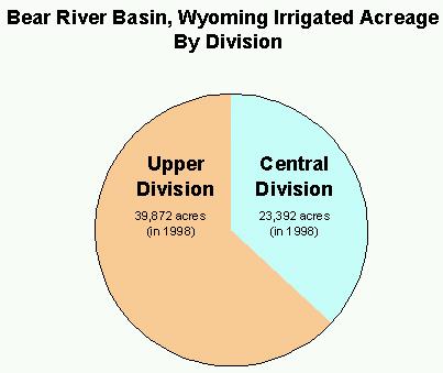
Using the GIS coverages, some statistics were generated to show the overall characteristics of the basin. Figure 2 shows the active irrigated acreage in 1998 by division. The Upper Division contains 40,000 acres and the Central Division contains 23,300 acres.
Figure 2 shows the water right permits by division for active irrigated acreage. The Upper Division has 319 active permits and the Central Division has 239 active permits. Note that this may not represent all water rights in the basin, only water rights associated with acreage defined as irrigated in 1998.
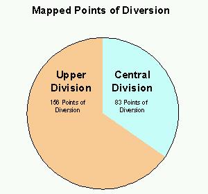
Figure 3 shows the 1998 active points of diversion by division. The Upper Division contains 156 and the Central Division contains 83 mapped points of diversion. Additional points of diversion may exist.
Figure 2:
| Figure 3: | Figure 4: |
|
|
COMMENTS AND CONCERNS
The water rights attribution process did not attempt to define all water rights in the basin nor determine a specific correspondence to the irrigated lands permitted by the water right. The coverages developed based on the irrigated acreage and water rights attributions should not be used to determine water right compliance, but are appropriate for the use intended in this study.
Sources:
Carr, Frank. Water Rights Attribution and Mapping, maps and spreadsheets, 1999.
O’Grady, M.; Carr, F.; and Meena, J. Bear River Basin Plan, Irrigated Lands GIS Data, July 14, 2000.
Wyoming State Engineer’s Office, Original water right records for surface and ground water permits.