Wyoming State Water Plan
Wyoming State Water Plan
Wyoming Water Development Office
6920 Yellowtail Rd
Cheyenne, WY 82002
Phone: 307-777-7626

Wyoming Water Development Office
6920 Yellowtail Rd
Cheyenne, WY 82002
Phone: 307-777-7626


| SUBJECT: |
Appendix L Environmental Use |
| PREPARED BY: | Bear River Basin Planning Team |
Introduction
This memorandum discusses the approach, analysis and results of the Wyoming Water Development Commission's Water Resource Evaluation of the Bear River Basin, Wyoming, Task 2E "Environmental Use." The task objectives were to:
APPROACH
The following data was collected to help identify environmental uses in the Bear River Basin:
RESULTS
Instream Flows
In 1986, the State of Wyoming passed legislation defining "instream flow" as a beneficial use of water, and stipulated how instream flow water rights are filed, evaluated and ultimately regulated. The legislation is codified under Wyoming statutes 41-3-1001 to 1014.
The law allows for instream flow water rights to be filed or granted on unappropriated water originating as natural flow or from storage in existing or new reservoirs. The use of natural flow sources is defined as the minimum needed to maintain or improve existing fisheries. The use of stored water is defined as the minimum needed to establish or maintain new or existing fisheries.
The law requires that the Game and Fish Commission identify stream segments for instream flow filings and the minimum flows required. The Wyoming Water Development Commission (WWDC) then files the application with the State Engineer's Office in the name of the State of Wyoming. According to the law the State of Wyoming is the only entity allowed to hold an instream flow permit. WWDC then performs the hydrologic analyses necessary to determine feasibility of providing the flows requested. The findings of the hydrologic analyses are then submitted to the Game and Fish Commission, the Legislature and the State Engineer for the use in evaluating the application for approval. The instream flow application is then subject to a public hearing, which is administered by the State Engineer.
The law provides protection for senior rights and compact allocation water. The following are summaries from the law:
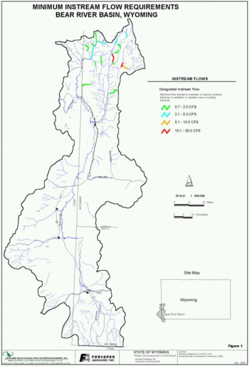
In the Bear River Basin there are currently 17 instream flow filings. A public hearing was held on April 27, 1999 for all filings. There was no significant opposition to the filings at the public hearing. At this time, none are permitted. All of the filings are tied to natural flow water and there are no diversions above the segments. Table 1 describes the instream flow filings in the Bear River Basin, Wyoming. The table contains:
The Game and Fish Commission identified the monthly flows required to maintain aquatic habitat, which generally follow the pattern of natural flow. Figure 1 shows the locations of instream flow filings in the basin. All of the filings are located in the Central Division of the Bear River Basin. The minimum flow requirements in the Bear River Basin range from 0.7 to 30.0 cfs. 10 of the requirements are less than 2.0 cfs.
The Game and Fish Commission has indicated that the instream flow filings are an insurance policy against unknown future development. The main goal for instream flow rights in the Bear River Basin is to help preserve and manage habitat for the Bonneville Cut Throat Trout, which is proposed for the Endangered Species List. The Game and Fish Commission has indicated that the Bear River Trout habitat the Central Bear River Basin is a better head water habitat for the Bonneville Cut Throat Trout than other areas of the basin.
| TABLE 1 INSTREAM FLOW FILINGS | |||||
|---|---|---|---|---|---|
| Segment Name | Priority | Stream Minimum (cfs) |
Stream Maximum (cfs) |
Stream Length (miles) |
HUC |
| Coal Creek Seg No. 1 | 6/20/95 | 1.8 | 7.5 | 0.80 | 16010102 |
| Coal Creek Seg No. 1 | 6/27/96 | 1.8 | 4.4 | 4.20 | 16010102 |
| Coantag Creek Segment No. 1 | 6/27/96 | 7.2 | 24.0 | 4.90 | 16010102 |
| Giraffe Creek Seg No. 1 | 6/27/96 | 1.5 | 5.5 | 2.40 | 16010102 |
| Hobble Creek Seg No. 1 | 6/20/95 | 30.0 | 48.0 | 2.70 | 16010102 |
| Huff Creek Seg No. 1 | 6/20/95 | 1.3 | 6.5 | 3.30 | 16010102 |
| Lander Creek IF Segment No. 1 | 8/25/97 | 1.1 | 0.40 | 16010102 | |
| Little White Ck IF Segment No. 1 | 8/25/97 | 1.2 | 2.9 | 2.50 | 16010102 |
| North Fork Smiths Fork R Seg No.1 | 8/25/97 | 2.1 | 16.0 | 2.40 | 16010102 |
| Packstirng Ck If Segment No. 1 | 8/25/97 | 0.7 | 1.30 | 16010102 | |
| Poker Hollow Ck IF Segment No 1 | 8/25/97 | 3.7 | 42.0 | 1.60 | 16010102 |
| Porcupine Creek Seg No. 1 | 12/19/95 | 1.5 | 7.5 | 1.30 | 16010102 |
| Raymond Creek Seg No. 1 | 12/19/95 | 1.4 | 1.9 | 1.60 | 16010102 |
| Salt Creek Seg No. 1 | 6/27/96 | 4.4 | 14.0 | 4.50 | 16010102 |
| Smiths Fork Seg No. 1 | 12/19/95 | 17.0 | 45.0 | 5.00 | 16010102 |
| Trespass Ck IF Segment No 1 | 8/25/97 | 1.1 | 1.00 | 16010102 | |
| Water Canyon Ck Seg No. 1 | 6/27/96 | 2.4 | 10.0 | 1.20 | 16010102 |
| Sources: Wyoming State Engineer's, Wyoming Instream Flow Applications Database, 2000. WWDC GIS coverage Wyoming Instream Flow Filings, 2000. | |||||
Mapping Data Source and Procedure
The following are the sources for the instream flow filings:
The GIS mapping shown here was obtained from WWDC. A few minor changes were made to the coverage. The coverage was clipped to the Bear River Basin Boundaries and the features of the segments were "unioned" to form one feature per segment.
Wetlands Mapping
The National Wetlands Inventory (NWI) of the U.S. Fish and Wildlife Service produces information on the characteristics, extent, and status of the Nation's wetlands and deepwater habitats. Federal, State, and local agencies, academic institutions, U.S. Congress, and the private sector use this information. The Emergency Wetland Resources Act of 1986 directs the Service to map the wetlands of the United States. The NWI has mapped 89% of the lower 48 states, and 31% of Alaska. The Act also requires the Service to produce a digital wetlands database for the United States. About 39% of the lower 48 states and 11% of Alaska are digitized. Congressional mandates require the NWI to produce status and trends reports to Congress at ten-year intervals. In 1982, the NWI produced the first comprehensive and statistically valid estimate of the status of the Nation's wetlands and wetland losses, and in 1990 produced the first update. Future national updates scheduled for 2000, 2010, and 2020.
The Spatial Data and Visualization Center downloaded the digital line graphs (dlg) from the NWI web page and converted the dlg data to Arc/Info vector coverages with matching attributes. Vector coverages include both line (riverine) and polygon (lacustrine and palustrine) wetland features.
Wetlands are lands transitional between terrestrial and aquatic systems where the water table is usually at or near the surface or the land is covered by shallow water. For purposes of the NWI classification, wetlands must have one or more of the following three attributes:
The wetland classification system is hierarchical, with wetlands and deepwater habitats divided among five major systems at the broadest level. The five systems include Marine (open ocean and associated coastline), Estuarine (salt marshes and brackish tidal water), Riverine (rivers, creeks, and streams), Lacustrine (lakes and deep ponds), and Palustrine (shallow ponds, marshes, swamps, sloughs). Systems are further subdivided into subsystems, which reflect hydrologic conditions. Below the subsystem is the class, which describes the appearance of the wetland in terms of vegetation or substrate. Each class is further subdivided into subclasses; vegetated subclasses are described in terms of life form and substrate subclasses in terms of composition. The classification system also includes modifiers to describe hydrology (water regime), soils, water chemistry (pH, salinity), and special modifiers relating to man's activities (e.g., impounded, partly drained).
The NWI coverage for the Bear River Basin contains 3 systems:
The three systems are divided into six subsystems:
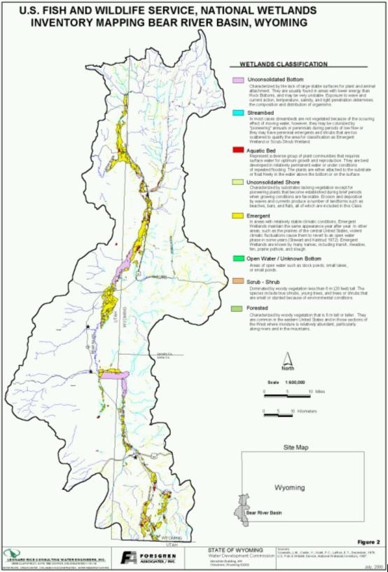
The subsystems are further divided into Classes. The Classes describes the general appearance of the habitat in terms of either the dominant life form of the vegetation or the physiography and composition of the substrate-features that can be recognized without the aid of detailed environmental measurements. Figure 2 shows the NWI coverage divided into eight classes.
The following list identifies and defines the classes in the Bear River Basin:
The wetlands mapping was overlayed on the GIS Irrigated Acreage coverage used in the Bear River Basin plan. More than half of the defined irrigated acreage is classified in the wetlands mapping as Emergent. This may be, inpart, due to the scale of the wetlands mapping, which varied between 1:20,000 and 1:132,000. Also, the Emergent wetlands classification reports to be known by many names, including meadow. Almost all of the irrigated acreage in the Bear River Basin is meadow composed of emergent plant types.
Minimum Reservoir Conservation Pools and Bypass Requirements
In general, conservation pools are intended to provide the minimum volume of water necessary to maintain the existing aquatic life in the reservoir. Because on-stream reservoirs disrupt the natural flow in a stream, minimum bypass requirements are often dictated during the permitting process to provide the minimum flow downstream required to maintain existing fisheries.
There is no indication that the other smaller reservoirs in the basin have conservation pool or bypass requirements. Table 2 shows the minimum reservoir conservation pools and bypass requirements for Sulphur Creek and Woodruff Narrows Reservoirs:
| TABLE 2 MINIMUM RESERVOIR POOLS AND RELEASES | ||
|---|---|---|
| Reservoir | Conservative Account (AF) | Minimum Downstream Release (cfs) |
| Sulphur Creek Reservoir | 4,180 | 9 |
| Woodruff Narrows Reservoir | 4000* | 10 |
| Sources: Wyoming Game and Fish *Temporary storage account of 4,000 acre-feet was set up to accommodate an agreement between the Reservoir Company and the Utah Department of Fish and Game to supply the 10 cfs winter minimum release for fishery purposes. | ||
Cokeville Meadows National Wildlife Refuge
The Cokeville Meadows National Wildlife Refuge is located along the Utah and Wyoming border south of the town of Cokeville, Wyoming. The area is approximately 16 miles long, bounded by Cokeville on the north and by the Beckwith-Quinn (BQ) diversion system. The refuge is maintained for Aquatic fowl production.
Table 3 outlines the wetland types and proposed management plan, based on the Proposed Bear River Valley Refuge Water Resource Analysis, U.S. Fish and Wildlife Service, December 20, 1988. Note that the refuge was referred to as the Bear River Valley Refuge during initial investigations and proposals.
| TABLE 3 COKEVILLE MEADOWS NATIONAL WILDLIFE REFUGE MANAGEMENT PLAN | ||
|---|---|---|
| Wetland Type | Acres | Management Plan: |
| Oxbows | 1,500 | 500 of the 1,500 acres will be drawn down each year on July 10. The remaining 1,000 acres will be maintained through the summer. | Seasonal Hay Meadows | 12,100 | Will be left to dry up naturally, be drained, or used to provide additional water to the brood ponds. |
| Brood Ponds | 1,000 | Will be flooded early spring and maintained full through August or later. |
| Total | 14,600 | |
| Sources: Bellinger, T. U.S. Fish and Wildlife Service, December 20, 1988. | ||
The above management plan was developed with the following assumptions and criteria:
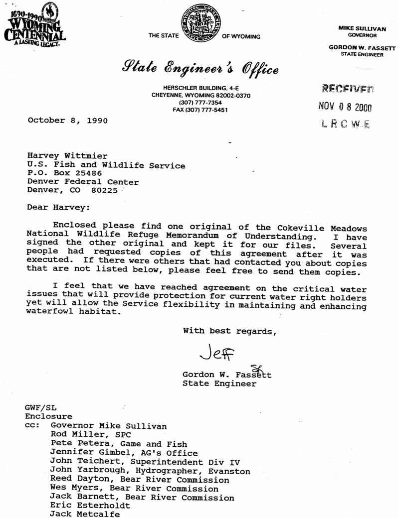
The Memorandum of Understanding between U.S. Fish and Wildlife Service and the Wyoming State Engineer was finalized in October 1990, Appendix A. The U.S. Fish and Wildlife Service has agreed to comply with all Wyoming Water Laws and to submit a petition to the proper State authority for change in use and other appropriate proceedings.
The Cokeville Meadows National Wildlife Refuge is in the land acquisition phase, currently purchasing land from willing sellers. The U.S. Fish and Wildlife Service has signed an agreement with the State Engineer's Office to maintain historical quantities and timing of depletions.
COMMENTS AND CONCERNS
None.
SOURCES
Bellinger, T. Proposed Bear River Valley Refuge Water Resource Analysis. U.S. Fish and Wildlife Service, Region 6, Water Resources Division; December 20, 1988.
Cowardin, L.M.; Carter, V.; Golet, F.C.; LaRoe, E.T. Classification of Wetlands and Deepwater Habitats of the United States. Performed for U.S. Department of the Interior Fish and Wildlife Service Office of Biological Services Washington, D.C. 20240. December, 1979.
U.S. Fish and Wildlife Service. National Wetland Inventory, 1997.
Wyoming State Engineer's Office. Wyoming Instream Flow Applications Database, 2000.
Wyoming State Engineer's Office. Memorandum of Understanding between U.S. Fish and Wildlife Service and Wyoming State Engineer, October 1990.
Wyoming Statutes 41-3-1001 to 1014.
Wyoming Water Development Commission. Wyoming Instream Flow Filings GIS Coverage, 2000.
Wyoming Game and Fish Department, Phone conversation and fax from Paul Dey, November 2, 2000.
APPENDIX A
Cokeville Meadows National Wildlife Refuge Memorandum of Understanding
MEMORANDUM OF UNDERSTANDING
between
U.S. FISH AND WILDLIFE SERVICE
and
WYOMING STATE ENGINEER
This Memorandum of Understanding is entered into between the United States of America acting through the Department of the Interior, Fish and Wildlife Service (Service), and the Wyoming State Engineer (WSE) for the following reasons:
B. The above-referenced Migratory Bird Conservation Act provides that no lands for the conservation of migratory birds may be acquired under the terms of the Act unless the State in which the area is located shall have consented by law to the acquisition. Section 23-1-106 of the Wyoming Statutes (W.S.) is enabling legislation which authorizes the Service to acquire lands in Lincoln County, Wyoming, near the town of Cokevilie, for the purpose of establishing a National Wildlife Refuge. The Service must enter into an agreement with the WSE as provided for in the enabling legislation, W.S. 23-1- 106(d).
This Memorandum of Understanding between the Service and the WSE is entered into under the authority of the National Wildlife Refuge System Administration Act (16 U.S.C. 668dd-668ee) for the express purposes of providing for the proper administration, preservation, management, and development of the proposed refuge area consistent with Wyoming State law governing the acquisition and utilization of water rights, and for meeting the terms of the legislative consent by the State for the establishment of the Refuge. The Service and WSE agree as follows:
b. The Service agrees that the operation of Pixley and BQ diversion dams, two Bear River diversion facilities which are key to appropriators in Wyoming within the proposed exterior boundary of the Refuge, will continue as in the past. The flashboards in the two dams will be removed and the diversion structures drained beginning no later than the 10th of July of each year, as directed by the Superintendent, Water Division IV, unless he determines that Service requests for additional diversions will not injure or impair any other Wyoming water users. Neither the operation of these two diversion dams nor the construction and operation of additional dikes on the Refuge shall in any way cause water flooding or other damage to landowners adjacent or downstream from lands owned by the Service. No additional diversions through the facilities will be allowed after July 10th of water from other sources, such as storage waters or groundwater, if such deliveries and diversions may cause any injury to holders of valid water rights. The United States agrees that the operation of the two diversion dams and the construction and operation of any additional dikes on the Refuge will be by the use of standard dam building and operating practices as recognized in the industry.
c. Should the Service wish to supplement the water supply to the Refuge by the purchase or lease of reservoir water or other source of supply, a separate agreement with the appropriate reservoir company or irrigation district or other appropriate entities may be necessary. The Service will consult with the WSE during development of and prior to closing of any such agreements.
d. The State of Wyoming has allocated to appropriators the increased depletions from the Bear River provided for in the 1980 Amended Bear River Compact, Article V. Due to water management changes by the Service, it is understood by the WSE that the Refuge may deplete more water than has occurred under historical practices. This increase in depletion above historic use cannot occur without prior approval of the WSE. The Service shall be required to determine the amount of any difference in depletion for Compact and State water law administration purposes subject to review of its findings by the WSE. The determination and administration of depletion amounts may require installation of measuring devices, evaporation pans, and other equipment necessary to estimate accurately depletions occurring on Refuge lands. The WSE may order the Service to install such devices and may require the Service to submit water budaet. diversion. storage, and consumption and use reports in order to assess and comply with Wyoming's obligations under the Compact, as amended.
e. The Service acknowledges that groundwater withdrawals that deplete the Bear River and its tributaries are covered under the Amended Bear River Compact. The Service recognizes it would not be able to offset additional depletions attributable to the Refuge through the use of depletive groundwater withdrawals.
f. If the Service desires to change the use of any water rights attached to lands on which conservation easements are obtained, those water right use changes must be filed with the appropriate State authority, as required by Wyoming law. The water on these easement lands must also be managed such that historic use practices are addressed and that no injury occurs to other Wyoming appropriators in the Bear River Basin.
IN WITNESS WHEREOF, the parties hereto have caused this Memorandum of Understanding (Agreement) to be executed and effective as of the latest date of the signatures hereinafter affixed.