Wyoming State Water Plan
Wyoming State Water Plan
Wyoming Water Development Office
6920 Yellowtail Rd
Cheyenne, WY 82002
Phone: 307-777-7626

Wyoming Water Development Office
6920 Yellowtail Rd
Cheyenne, WY 82002
Phone: 307-777-7626


| SUBJECT: |
Appendix K Surface Water Hydrology |
| PREPARED BY: | HKM Engineering Inc. |
| DATE: | February 2002 |
INTRODUCTION
Water availability models are to be developed to represent dry year, normal year, and wet year hydrologic conditions throughout the Northeast Wyoming River Basins planning area. Several key inputs are necessary to model the water availability including the current irrigated land base, crop water requirements, municipal and industrial surface water demands, and regulation by reservoir storage facilities. This information was developed through the Task 2 work effort. Schematic representations of the water availability models have been developed identifying the appropriate location of model nodes in relation to the various surface water demands, return flows, and storage regulation. Model nodes are located, to the extent possible, at historic streamflow gaging stations in order to take advantage of the historic records of streamflow at these locations. The Northeast Wyoming River Basins, however, are characterized by a scarcity of historic streamflow records. It is therefore necessary to locate model nodes at many locations with no record of streamflow, to appropriately simulate water use in the various drainages. This memorandum summarizes the methodology used to collect the historic records of streamflow, establish a study period for modeling, and to extend or fill-in the streamflow data where records are unavailable. The methodology used to estimate natural (virgin) streamflow at ungaged model nodes is also discussed in this memorandum.
HISTORIC STREAMFLOW RECORDS
HKM inventoried the available records of streamflow in the Northeast Wyoming River Basins. Data from the following four sources were used for this study:
The order of priority for use of data available from multiple sources was as numbered above.
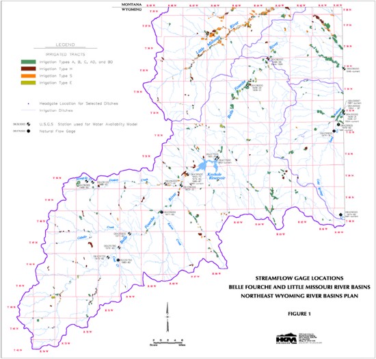
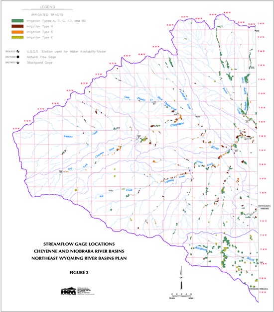
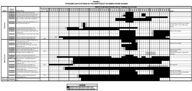
The location of the various streamflow gaging stations are plotted in relation to the significant storage reservoirs and the irrigated lands mapped by HKM (Figures 1 and 2). The streamflow gages that are relatively free from the influence of depletions or storage regulations are characterized as natural flow stations. Where reasonably possible, those gages that are impacted by upstream depletions were adjusted to remove these effects. The list of streamflow gages inventoried for this study is provided in Table 1. Figure 3 illustrates the period of record for all of the streamflow stations available in the basins.
As shown in Figure 3, prior to 1970, there were only 13 streamflow gages in operation in the Northeast Wyoming River Basins. Beginning in the 1970s and 1980s, with the installation of an additional 18 streamflow gages, records for a total of 31 streamflow stations became available.
TABLE 1
STREAMFLOW STATIONS IN THE NORTHEAST WYOMING RIVER BASINS
| Basin | Station Number |
Station Name | Natural Flow | Period of Record in Water Years ** |
Note |
| Cheyenne | 06364700 | Antelope Creek Near Teckla, WY | NO | 1978-1981 | |
| 06365300 | Dry Fork Cheyenne River Near Bill, WY | NO | 1977-1981, 1986-1987 | ||
| 0635900 | Cheyenne River Near Dull Center, WY | NO | 1976-1981, 1986-1987 | ||
| 06375600 | Little Thunder Chreek Near Hampshire, WY | NO | 1978-1981, 1988-1998 | ||
| 06376300 | Black Thunder Creek Near Hampshire, WY | NO | 1973-1990 | ||
| 06378300 | Lodgepole Creek Near Hampshire, WY | NO | 1978-1981 | ||
| 06379600 | Box Creek Near Bill, WY | YES | 1956-1958 | ||
| 06386000 | Lance Creek Near Riverview, WY | NO | 1948-1954, 1956-1983 | ||
| 06386500 | Cheyenne River Near Spencer, WY | NO | 1949-1974 | ||
| 06392900 | Beaver Creek at Mallo Camp, Near Four Corners, WY | YES | 1975-1982, 1991-current | ||
| 06392950 | Stockade Beaver Creek Near Newcastle, WY | NO | 1975-1982, 1991-current | ||
| 06394000 | Beaver Creek Near Newcastle, WY | NO | 1945-1998 | ||
| 06394500 | Beaver Creek Near Burdock, SD | NO | 1905-1907, 1929-1932 | Abt. 2 mi. into SD | |
| 06395000 | Cheyenne River at Edgemont, SD | NO | 1903-1907, 1928-1933, 1947- | Several Miles into SD; No winter records 1903-1906 | |
| Belle Fourche | 06425720 | Belle Fourche River Below Rattlesnake Creek, Near Piney, WY | NO | 1976-1983 | |
| 06425750 | Coal Creek Near Piney, WY | YES | 1981-1983 | ||
| 06425780 | Belle Fourche River Above Dry Creek Near Piney, WY | NO | 1976-1983 | ||
| 06425900 | Caballo Creek at Mouth Near Piney, WY, WY | NO | 1977-1983 | ||
| 06425950 | Raven Creek Near Moorcroft, WY | YES | 1977-1983 | ||
| 06426000 | Belle Fourche River Near Moorcroft, WY, WY | NO | 1923-1933 | ||
| 06426100 | Stonepile Creek at Gillette, WY | YES | 1988-1992 | No Winter records; Adjusted for diversions using Burlington Lake Ditch | |
| 06426400 | Donkey Creek Near Moorcroft, WY | NO | 1977-1981 | ||
| 06426500 | Belle Fourche River Below Moorcroft, WY | NO | 1943-1970, 1976-1983, 1986-1987, 1991-current | ||
| USBR Gage | Inflow to Keyhole Reservoir | NO | USBR: 1952-current | Adjusted for evaporation | |
| USBR Gage | Belle Fourche - Keyhole Reservoir Releases | NO | USBR: 1952-current | ||
| 06427500 | Belle Fourche River Below Keyhole Reservoir, WY | NO | 1951-1995 | ||
| 06428000 | Belle Fourche River at Hulette, WY | NO | 1929-1933, 1938-1952 | ||
| 06428200 | Belle Fourche River Near Alva, WY | NO | 1989-1998 | No winter records | |
| 06428500 | Belle Fourche River at Wyoming-South Dakota State Line | NO | 1947-current | ||
| 06429500 | Cold Springs Creek at Buckhorn, WY | YES | 1975-1982, 1991-current | ||
| 06429900 | Sand Creek at Ranch A Near Beulah, WY | YES | 1975-1976 | Combined with Station 06429905 | |
| 06429905 | Sand Creek Near Ranch A Near Beulah, WY | YES | 1976-1983, 1991-current | ||
| 06430500 | Redwater Creek at Wyoming-South Dakota State Line, WY | NO | 1929-1931, 1936-1937, 1954- | Adjusted for diversion using Murrey Ditch | |
| Niobrara | 06454000 | Niobrara River at Wyoming-Nebraska State Line, WY | NO | 1956-1994 |
**Unless otherwise noted, records were obtained from the USGS
FIGURE 3
STREAMFLOW STATIONS IN THE NORTHEAST WYOMING RIVER BASINS
click to enlarge
STUDY PERIOD
It is important in any water availability evaluation to select a study period that is long enough to include a variety of hydrologic conditions including an extended period of dry years as well as wet years and normal years. At the same time, it is also important not to select a study period so long that many streamflows must be synthesized to fill-in missing data.
It is desirable in evaluating long-term hydrologic conditions to utilize streamflow records for a station that has a long period of continuous records and that reflects natural (virgin) flow, unaffected by upstream depletions or storage regulation. Unfortunately, no such streamflow gaging station exists in, or in near vicinity to, the Northeast Wyoming River Basins. The USGS has, however, maintained streamflow stations on Beaver Creek near Newcastle (#06394000) and the Cheyenne River at Edgemont, South Dakota (#06395000) since the mid 1940s (Table 1). The Beaver Creek gage was discontinued in 1998. The records for these gages are impacted by upstream irrigation depletions and storage, primarily in the form of stock ponds. The change in carryover storage from year to year is however expected to be relatively minor and the amount of irrigation depletion in relation to the total streamflow is not expected to vary greatly from year to year. The records for these stations although non-natural can therefore be used as a reasonable representation of annual hydrologic conditions. The USGS has also maintained a streamflow station on the Belle Fourche River below Moorcroft (#06426500) since 1944 with some gaps in the record in the 1970s and 1980s (Table 1). Similar to stations on Beaver Creek and the Cheyenne River, the streamflow at this gage is impacted by upstream irrigation depletion and stock pond storage. The record for this station can however be used to represent hydrologic conditions in the Belle Fourche drainage. The USBR maintains records of computed inflows into Keyhole Reservoir downstream from the Moorcroft gage (#06426500). HKM utilized this information to develop a regression relationship between streamflows at the upstream Moorcroft gage and inflows to Keyhole Reservoir to fill-in the missing records in the 1970s and 1980s. The relationship is shown below:
Q06426500 = 0.671* QKeyhole Inflow . 386.2Where:
Q06426500 is monthly streamflow at Gage #06426500 in acre-feet and
QKeyhole Inflow is computed inflow to Keyhole Reservoir from USBR in acre-feet.
The coefficient of determination (R2) for this relationship is 0.87. The coefficient of determination is defined as the proportion of variation in the independent variable that can be explained by variation in the dependent variable (DeVore, 1987). The higher the value of R2, the stronger the relationship between the two variables. A perfect relationship would have an R2 = 1.0. Regression of hydrologic data resulting in R2>0.7 is typically considered strong enough for data estimating. The regression analysis and the resulting monthly streamflows for this station are provided in Appendix A.
The recorded and estimated streamflow records from the gages on Beaver Creek (#06394000), the Cheyenne River (#06395000), and the Belle Fourche River (#06426500) are selected as representative of the hydrologic conditions throughout the Northeast Wyoming River basins.
Figures 4, 5, and 6 are Cumulative Surplus/Deficit plots for Beaver Creek, the Cheyenne River, and the Belle Fourche River respectively for the longest concurrent period of record (1947 to 1997 or 1999). A Cumulative Surplus/Deficit plot represents a running total of the annual deviations from the long-term mean annual streamflow. Downward sloping lines (left to right) represent periods of time during which annual streamflow is less than the long-term mean (dry periods). Conversely, upward sloping lines represent years, which are wetter than average (wet periods). As can be seen from these plots, the hydrologic conditions can vary considerably throughout the Northeast Wyoming River Basins in any given period of years. By way of example, the period 1964 to 1970 is generally a wet period on Beaver Creek. Whereas, on the Cheyenne River, this same period is generally average, and on the Belle Fourche River, 1964 to 1970 is generally a dry period. Some similarities do however exist throughout the study area. The periods 1959 to 1961, 1979 to 1985, and 1988 to 1990 are generally dry periods at all locations. The years 1962 and 1978 are also extreme wet years at all locations.
FIGURE 4
CUMULATIVE SURPLUS/DEFICIT OF ANNUAL HISTORIC FLOWS
Beaver Creek Near Newcastle, WY (Station 06394000)
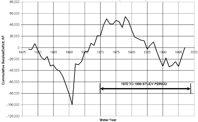
FIGURE 5
CUMULATIVE SURPLUS/DEFICIT OF ANNUAL HISTORIC FLOWS
Cheyenne River at Edgemont, SD (Station 06395000)
FIGURE 6
CUMULATIVE SURPLUS/DEFICIT OF ANNUAL HISTORIC FLOWS
Belle Fourche River Below Moorcroft, WY (Station 06426500)
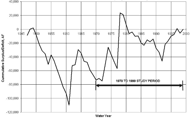
Based on an evaluation of the long-term hydrologic conditions at the three representative streamflow stations, together with the an understanding of the availability of historic streamflow records, the 30-year period 1970 through 1999 is selected as a candidate study period. The annual streamflows at each of these stations for the period 1947 to 1997 or 1999 are summarized in Table 2. The average annual flow for the period 1970 to 1999 ranges from 9% drier than the long-term period on the Cheyenne River to 12% wetter than the long- term period on the Belle Fourche River.
TABLE 2
LONG TERM AVERAGE ANNUAL
FLOW COMPARISON TO 1970-1999
AVERAGE ANNUAL FLOW
| YEAR | Annual Flow in Acre-Feet | ||
|---|---|---|---|
| Beaver Creek Near Newcastle, WY 06394000 | Cheyenne River at Edgemont, SD 06395000 | Belle Fourche River Below Moorcroft, WY 06426500 | |
| 1947 | 19,703 | 52,451 | 8,999 |
| 1948 | 21,855 | 74,782 | 26,989 |
| 1949 | 32,921 | 51,613 | 19,570 |
| 1950 | 10,925 | 27,659 | 7,965 |
| 1951 | 11,669 | 68,919 | 4,751 |
| 1952 | 16,476 | 73,500 | 7,726 |
| 1953 | 28,225 | 42,095 | 14,037 |
| 1954 | 6,100 | 14,868 | 2,288 |
| 1955 | 24,273 | 104,588 | 31,891 |
| 1956 | 14,573 | 31,719 | 9,290 |
| 1957 | 19,478 | 79,214 | 5,132 |
| 1958 | 13,292 | 74,108 | 5,868 |
| 1959 | 7,133 | 17,624 | 4,413 |
| 1960 | 7,443 | 11,881 | 9,097 |
| 1961 | 3,715 | 9,339 | 825 |
| 1962 | 94,071 | 314,408 | 75,153 |
| 1963 | 20,810 | 72,168 | 18,993 |
| 1964 | 28,424 | 40,155 | 40,060 |
| 1965 | 39,333 | 101,877 | 12,633 |
| 1966 | 22,155 | 46,363 | 6,120 |
| 1967 | 37,732 | 85,226 | 16,413 |
| 1968 | 18,708 | 35,927 | 6,549 |
| 1969 | 39,198 | 75,129 | 10,816 |
| 1970 | 22,458 | 22,264 | 10,842 |
| 1971 | 41,118 | 153,235 | 20,218 |
| 1972 | 33,801 | 30,052 | 14,051 |
| 1973 | 13,645 | 57,980 | 40,434 |
| 1974 | 21,996 | 20,970 | 44,264 |
| 1975 | 28,898 | 28,202 | 7,583 |
| 1976 | 20,510 | 27,407 | 7,543 |
| 1977 | 12,102 | 19,855 | 7,876 |
| 1978 | 41,784 | 223,740 | 98,331 |
| 1979 | 14,393 | 61,675 | 15,391 |
| 1980 | 7,085 | 32,972 | 3,712 |
| 1981 | 9,954 | 27,855 | 4,646 |
| 1982 | 19,917 | 62,767 | 20,283 |
| 1983 | 19,842 | 39,746 | 11,590 |
| 1984 | 21,339 | 74,519 | 18,478 |
| 1985 | 7,801 | 12,831 | 7,880 |
| 1986 | 30,004 | 73,186 | 14,496 |
| 1987 | 27,558 | 64,260 | 25,747 |
| 1988 | 7,171 | 8,725 | 15,069 |
| 1989 | 7,335 | 17,079 | 21,935 |
| 1990 | 10,762 | 22,894 | 4,576 |
| 1991 | 36,995 | 132,999 | 12,248 |
| 1992 | 6,889 | 9,408 | 4,994 |
| 1993 | 25,031 | 68,156 | 41,836 |
| 1994 | 29,359 | 45,633 | 23,223 |
| 1995 | 14,005 | 43,391 | 24,721 |
| 1996 | 37,581 | 52,131 | 20,135 |
| 1997 | 40,220 | 69,180 | 26,752 |
| 1998 | 54,230 | 11,136 | |
| 1999 | 59,770 | 23,556 | |
| Avg 47-99 | 22,505 | 58,919 | 17,908 |
| Avg 70-99 | 21,770 | 53,904 | 20,118 |
On the Cheyenne River, the period 1970 to 1999 includes the extended dry periods 1972 to 1977, 1980 to 1983, and 1988 to 1990 as well as the wet period from 1978 to 1979. This period contains three out of six of the driest years of the 1947 . 1999 records including 1985, 1988, and 1992. The period also contains three out of six of the wettest years of record in 1971, 1978, and 1991. The extreme dry years and wet years (driest and wettest years) are defined here as those with exceedance or non-exceedance probabilities of less than approximately 10 percent.
The 1970 to 1999 period on the Belle Fourche River contains the dry periods from 1975 to 1977, 1979 to 1986 and 1990 to 1992 as well as the wet periods 1973 to 1974 and 1993 to 1997. This period also contains three of the six driest years of the 1947 . 1999 records in 1980, 1981, and 1990 and 4 of the six wettest years of record in 1973, 1974, 1978, and 1993.
On the Beaver Creek at Newcastle (#06394000), the period 1970 to 1999 includes the extended dry periods from 1979 through 1985 and 1988 through 1990 as well as the wet periods from 1971 to 1972, 1986 to 1987, and 1996 to 1997. This period also contains three out of six of the driest years of the 1947 . 1997 records including 1980, 1988, and 1992. The period also contains three out of six of the wettest years of record in 1971, 1978, and 1997.
In summary, the period 1970 through 1999 contains extended periods of dry years at all locations including some of the driest years of record as well as periods of normal and wet hydrologic conditions. This period also has the greatest abundance of recorded streamflow data and therefore requires less data synthesis. A study period of 1970 through 1999 is therefore appropriate for purposes of water availability modeling for the Northeast Wyoming River Basin Plan.
The remainder of this memorandum describes the methodologies used to determine the typical dry year, normal year, and wet year monthly flows required at each of the model nodes.
DATA EXTENSION
The spreadsheet modeling approach used for the Basin Plan utilizes model nodes located at historic streamflow gaging stations in order to take advantage of the historic records of streamflow at these locations. These records however contain many data gaps during the 1970 to 1999 study period (Figure 3). Monthly streamflows must therefore be estimated for those months, during the study period, with no recorded streamflow data.
The monthly record extension approach used in this study follows the procedure used by the USGS in recent studies in Montana (USGS WRI 89-4165, 1989: USGS WRI 89-4082, 1989). This mixed-station procedure uses the best base station from among all available base stations to fill in each month of missing data for a given gage. It is therefore possible that several different base stations may be used to fill in different months of missing data for a given station. The base station producing the smallest standard error of prediction is used for each particular month. The monthly record extension procedure also offers the option of using cyclic or noncyclic equations to fill in missing records. If the cyclic option is selected, an extension equation is computed for each month using only concurrent streamflows for the month. If the noncyclic option is selected, a single extension equation is computed using all concurrent streamflows. The smallest standard error criterion is used to select between the cyclic or noncyclic option for each month of missing record. For this study, the cyclic option is used only if the base station and the short record station have at least five concurrent monthly streamflows. The noncyclic option is used in all other cases. The technique used to estimate missing values in this study was developed by Hirsch and is referred to as MOVE.1 (Maintenance of Variance Extension, Type 1). This technique offers the advantage over ordinary least-squares regression of preserving the variance of the unextended records (Alley and Burns, 1983). The MOVE.1 technique differs from ordinary least-squares regression in that ordinary regression minimizes the squared vertical deviations of the response variable from the regression line, whereas the MOVE.1 technique minimizes the areas of the right triangles formed by the horizontal and vertical deviations from the regression line (USGS WRI 89-4165, 1989). This procedure is carried out using a computer program developed by the USGS.
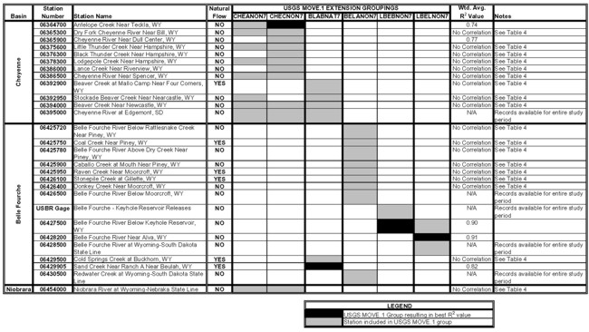
The USGS streamflow stations are divided into hydrologically similar groups with each group having at least one gage with sufficient data to develop relationships based on concurrent streamflow for the entire study period. The groupings also represent stations affected by similar reservoir operations. In particular, those stations below Keyhole Reservoir are grouped together because they all experience the same impacts from Keyhole operations. The monthly flow extension procedure is performed for each of these groupings of monthly streamflow data. There is a certain amount of overlap in hydrologic similarity among the various groupings. Some streamflow stations are therefore included in multiple groups. The station groupings and the resulting coefficients of determination (R2) are provided in Table 3. Regression of hydrologic data resulting in R2>0.7 is typically considered strong enough for data estimating. This criterion was used in evaluating the results of the regression analyses. The results of the MOVE.1 analyses are provided in Appendix B.
As shown in Table 3 in many instances no significant correlation (R2<0.7) could be found using concurrent monthly streamflows between any base station and the short record station. Annual flow regression rather than monthly flow regression was performed in these instances to fill-in the missing streamflow data. The results of this analysis including the base station record used to fill-in the missing data at the short record station, the regression equation, and the resulting coefficient of determination (R2) are summarized in Table 4. The supporting computations and graphic displays of the results of the annual flow regression analyses are provided in Appendix C. As noted in Table 4, in some cases, no significant correlation (R2<0.7) could be found using the annual flow regression either. Three of these stations were dropped from the study. Four other stations on Beaver Creek and the Niobrara River were retained and the study periods for modeling were adjusted to utilize historic records only (Table 4). The monthly streamflows for the years of missing data were estimated by applying the average monthly distribution for the period of recorded streamflow to the estimated total annual flow. For those instances when records for some months are available, the recorded streamflows are used and subtracted from the estimated annual total. The remaining months of missing data are then filled-in using the average monthly distribution for these months applied to the total remaining streamflow for the partial year.
TABLE 3
CORRELATION RESULTS BASED ON MONTHLY DATA
click to enlarge
TABLE 4
STATIONS IN THE NORTHEAST WYOMING RIVER BASINS
| Basin | Station Number | Station Name | Natural Flow | Station Used in Regression | R2 Value | Regression Equation | Notes |
|---|---|---|---|---|---|---|---|
| Cheyenne | 06365300 | Dry Fork Cheyenne River Near Bill, WY | NO | Cheyenne River at Edgemont, SD (Station 06395000) | 0.97 | Y=0.012486X-340.33 | |
| 06375600 | Little Thunder Creek Near Hampshire, WY | NO | Cheyenne River at Edgemont, SD (Station 06395000) | 0.94 | Y=0.038268X-779.37 | ||
| 06376300 | Black Thunder Creek Near Hampshire, WY | NO | Cheyenne River at Edgemont, SD (Station 06395000) | 0.93 | Y=0.12044X-963.54 | ||
| 06378300 | Lodgepole Creek Near Hampshire, WY | NO | Cheyenne River at Edgemont, SD (Station 06395000) | 0.99 | Y=0.10146X-98.335 | ||
| 06386000 | Lance Creek Near Riverview, WY | NO | Cheyenne River at Edgemont, SD (Station 06395000) | 0.93 | Y=0.30488X-820.91 | ||
| 06386500 | Cheyenne River Near Spencer, WY | NO | Cheyenne River at Edgemont, SD (Station 06395000) | 0.99 | Y=0.89571X-8219.4 | ||
| 06392900 | Beaver Creek at Mallo Camp Near Four Corners, WY | YES | No Correlation | Study Period Modified to 1975-1982, 1992-1997 | |||
| 06392950 | Stockade Beaver Creek Near Newcastle, WY | NO | No Correlation | Study Period Modified to 1975-1982, 1992-1997 | |||
| 06394000 | Beaver Creek Near Newcastle, WY | NO | No Correlation | Study Period Modified to 1975-1982, 1992-1997 | |||
| Belle Fourche | 06425720 | Belle Fourche River Below Rattlesnake Creek, Near Piney, WY | NO | Belle Fourche River Below Moorcroft, WY Station(06426500) | 0.92 | Y=0.072446X+192.57 | |
| 06425750 | Coal Creek Near Piney, WY | YES | No Correlation | Unable to find significant correlation with any available station | |||
| 06425780 | Belle Fourche River Above Dry Creek, Near Piney, WY | NO | Belle Fourche River Below Moorcroft, WY (Station 06426500) | 0.98 | Y=0.14088X+176.13 | ||
| 06425900 | Caballo Creek at Mouth, Near Piney, WY | NO | Belle Fourche River Below Moorcroft, WY (Station 06426500) | 0.99 | Y=0.084892X+297.37 | ||
| 06425950 | Raven Creek Near Moorcroft, WY | YES | Belle Fourche River Below Moorcroft, WY (Station 06426500) | 0.99 | Y=0.023728X+126.42 | ||
| 06426100 | Stonepile Creek at Gillette, WY | YES | No Correlation | Adjusted for diversions; Unable to find significant correlation with any available station | |||
| 06426400 | Donkey Creek Near Moorcroft, WY | NO | Belle Fourche River Below Moorcroft, WY (Station 06426500) | 0.99 | Y=0.27550X+874.51 | ||
| 06429500 | Cold Springs Creek at Buckhorn, WY | YES | No Correlation | Unable to find significant correlation with any available station | |||
| Niobrara | 06454000 | Niobrara River at Wyoming-Nebraska State | YES | No Correlation | Study Period modified to 1970-1994 |
The average monthly and annual streamflows during the study period are summarized in Table 5, for the gaging stations selected for use in the water availability models. The recorded and extended monthly streamflows for each year of the study period are provided in Appendix D for each station.
Table 5
SUMMARY OF AVERAGE MONTHLY AND ANNUAL FLOWS (1970 TO 1999 unless otherwise noted)
AT GAGED MODEL NODES
| Basin | Station Number |
Station Name | Natural Flow |
Average Streamflow for 1970-1999 in Acre-Feet | Note | ||||||||||||
| Oct | Nov | Dec | Jan | Feb | Mar | Apr | May | Jun | Jul | Aug | Sep | Annual | |||||
| Cheyenne | 06364700 | Antelope Creek Near Teckla, WY | NO | 97 | 64 | 18 | 22 | 159 | 545 | 291 | 1,520 | 1,005 | 361 | 148 | 93 | 4,323 | |
| 06365300 | Dry Fork Cheyenne River Near Bill, WY | NO | 3 | 6 | 5 | 3 | 17 | 44 | 20 | 194 | 37 | 30 | 8 | 1 | 366 | ||
| 0635900 | Cheyenne River Near Dull Center, WY | NO | 176 | 101 | 26 | 36 | 407 | 798 | 633 | 3,475 | 2,247 | 854 | 425 | 66 | 9,244 | ||
| 06375600 | Little Thunder Chreek Near Hampshire, WY | NO | 3 | 4 | 5 | 5 | 48 | 86 | 11 | 824 | 131 | 135 | 100 | 2 | 1,354 | ||
| 06376300 | Black Thunder Creek Near Hampshire, WY | NO | 307 | 16 | 0 | 51 | 272 | 846 | 308 | 1,788 | 671 | 549 | 405 | 498 | 5,710 | ||
| 06378300 | Lodgepole Creek Near Hampshire, WY | NO | 1 | 2 | 1 | 1 | 2 | 45 | 33 | 223 | 91 | 32 | 34 | 1 | 464 | ||
| 06386000 | Lance Creek Near Riverview, WY | NO | 133 | 111 | 83 | 333 | 870 | 1,205 | 902 | 5,594 | 2,717 | 2,993 | 2,078 | 694 | 17,713 | ||
| 06386500 | Cheyenne River Near Spencer, WY | NO | 275 | 233 | 71 | 1,023 | 1,487 | 866 | 2,040 | 20,050 | 9,286 | 2,103 | 535 | 3,453 | 41,423 | ||
| 06392900 | Beaver Creek at Mallo Camp, Near Four Corners, WY | YES | 112 | 102 | 100 | 97 | 98 | 127 | 138 | 136 | 144 | 131 | 120 | 112 | 1,415 | Study Period: 1975-1982, 1992-1997 | |
| 06392950 | Stockade Beaver Creek Near Newcastle, WY | NO | 786 | 763 | 785 | 769 | 721 | 877 | 785 | 654 | 675 | 699 | 730 | 751 | 8,996 | Study Period: 1975-1982, 1992-1997 | |
| 06394000 | Beaver Creek Near Newcastle, WY | NO | 876 | 804 | 796 | 881 | 2,381 | 5,716 | 2,353 | 3,250 | 2,339 | 1,106 | 797 | 497 | 21,796 | Study Period: 1975-1982, 1992-1997 | |
| 06395000 | Cheyenne River at Edgemont, SD | NO | 1,910 | 1,416 | 684 | 800 | 3,106 | 8,847 | 4,275 | 14,156 | 10,524 | 4,720 | 3,269 | 1,700 | 55,407 | ||
| Belle Fourche | 06425720 | Belle Fourche River Below Rattlesnake Creek, Near Piney, WY | NO | 6 | 6 | 12 | 24 | 79 | 212 | 66 | 685 | 236 | 101 | 149 | 20 | 1,596 | |
| 06425780 | Belle Fourche River Above Dry Creek Near Piney, WY | NO | 21 | 6 | 14 | 45 | 190 | 611 | 131 | 1,097 | 282 | 239 | 179 | 70 | 2,887 | ||
| 06425900 | Caballo Creek at Mouth Near Piney, WY, WY | NO | 13 | 10 | 1 | 10 | 27 | 221 | 30 | 788 | 76 | 99 | 45 | 18 | 1,339 | ||
| 06425950 | Raven Creek Near Moorcroft, WY | YES | 6 | 0 | 0 | 2 | 54 | 169 | 3 | 78 | 2 | 7 | 13 | 0 | 333 | ||
| 06426400 | Donkey Creek Near Moorcroft, WY | NO | 34 | 18 | 33 | 20 | 37 | 1,707 | 145 | 2,309 | 104 | 17 | 5 | 4 | 4,434 | ||
| 06426500 | Belle Fourche River Below Moorcroft, WY | NO | 682 | 203 | 149 | 420 | 1,761 | 4,664 | 2,268 | 5,169 | 2,134 | 997 | 515 | 281 | 19,243 | ||
| USBR Gage | Belle Fourche River - Total Keyhole Reservoir Discharge | NO | 114 | 320 | 0 | 1 | 0 | 881 | 784 | 2,149 | 2,402 | 4,821 | 4,526 | 761 | 16,759 | ||
| 06427500 | Belle Fourche River Below Keyhole Reservoir, WY | NO | 257 | 260 | 103 | 104 | 96 | 1,015 | 760 | 2,194 | 2,362 | 4,833 | 4,600 | 833 | 17,417 | ||
| 06428200 | Belle Fourche River Near Alva, WY | NO | 1,826 | 1,648 | 1,063 | 1,375 | 2,419 | 7,705 | 7,511 | 10,171 | 7,526 | 4,925 | 4,981 | 1,998 | 53,148 | ||
| 06428500 | Belle Fourche River at Wyoming-South Dakota State Line | NO | 2,307 | 2,082 | 1,272 | 1,741 | 3,233 | 10,987 | 10,552 | 15,575 | 12,134 | 6,507 | 5,402 | 2,336 | 74,127 | ||
| 06429905 | Sand Creek Near Ranch A Near Beulah, WY | YES | 1,312 | 1,307 | 1,285 | 1,237 | 1,092 | 1,231 | 1,288 | 1,881 | 1,776 | 1,499 | 1,480 | 1,334 | 16,722 | ||
| 06430500 | Redwater Creek at Wyoming-South Dakota State Line, WY | NO | 2,108 | 2,077 | 2,043 | 2,006 | 1,928 | 2,240 | 2,367 | 3,697 | 3,135 | 2,190 | 2,245 | 2,119 | 28,155 | ||
| Niobrara | 06454000 | Niobrara River at Wyoming-Nebraska State Line, WY | NO | 150 | 151 | 159 | 179 | 207 | 316 | 297 | 249 | 208 | 143 | 151 | 118 | 2,328 | Study Period: 1970-1994 |
NATURAL FLOW AT UNGAGED MODEL NODES
Records of streamflow from the limited number of gaging stations in planning area are used to the extent available to represent flow at model nodes. However, to fully represent water use in the various drainages, estimates of natural flow are also required at many model nodes where records from USGS or SEO streamflow stations are unavailable. HKM evaluated several alternatives for estimating natural flow at these locations including:
The downstream gaging stations are typically highly influenced by irrigation depletions and storage regulation. To develop natural flows using Alternative 1, the records for the downstream station would first need to be adjusted to remove these influences. Insufficient data is, typically, available to make these adjustments. It is therefore concluded that the first alternative does not yield reliable estimates of natural flow in most cases. The one exception is Donkey Creek, southeast of Gillette in the Belle Fourche River basin. Alternative 1 yielded the most reasonable estimates of natural flow for this location as evaluated during the calibration of the water availability models. The depletions (diversions minus return flows) used to make the adjustments to the downstream gage records are based on three representative hydrologic conditions (wet, normal, and dry years) and are taken from the water availability modeling work. The natural flow estimates for this location is therefore provided for these three representative hydrologic conditions only. This is in contrast to the estimates of natural flow at the other ungaged node locations for which natural flow estimates are provided for each month and each year within the study period. The selection of the years used to represent wet, normal, and dry conditions are discussed in the next section. The derivation of natural flow at this location is provided in Appendix E.
The USGS is currently updating the work originally developed by Lowham in the report "Streamflows in Wyoming" (USGS, 1988). Unfortunately, at the time of this writing, that work is several months away from completion. The 1988 USGS report presents regression equations, which rely on drainage area and either average annual precipitation or mean basin elevation to estimate mean annual flow. The equation for the plains region utilizes average annual precipitation and is applicable to the majority of the drainages within the planning area. According to personnel with the USGS in Cheyenne currently performing the updated work, the average annual precipitation data used in developing the equations in the 1988 report, for the plains region cannot be documented or verified. Data from the PRISM database will be used in developing the updated equations (www.ocs.orst.edu/prism/). Alternative 2 was dropped from further consideration due to the questionable validity of the original equations for the plains region.
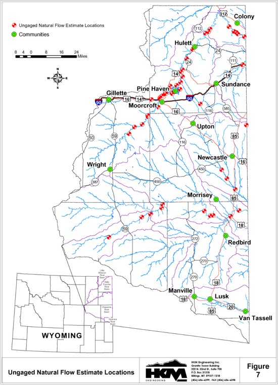
Natural flow for the majority of the ungaged model nodes was estimated using the third alternative, which relies on measured natural flow at selected streamflow gages in the Northeast Wyoming River Basins. The natural flow gage in nearest proximity and with the most similar hydrologic conditions was used to estimate natural flow at the ungaged locations. The original selections were further evaluated and, in some cases modified, as part of the calibration of the water availability models. In addition to average annual natural flow at the ungaged model nodes, it is necessary to generate sequential monthly flows at these sites for all years of the study period. This is accomplished by selecting a natural flow gaging station having similar hydrologic characteristics and multiplying the sequential monthly flows at the gaged location by the ratio of the ungaged average annual natural flow to the gaged average annual natural flow. The time distribution of monthly flows at the ungaged sites is, therefore, represented by the streamflow at similar gaged sites. The streamflow gages used to estimate monthly and annual natural flow at the ungaged model nodes are summarized in Table 6. The average monthly and annual streamflows for the study period, for the ungaged model nodes are summarized in Table 7. The estimated monthly natural flows for each year of the study period are provided in Appendix F for each ungaged model node.
Table 6
STREAMFLOW GAGES USED TO ESTIMATED NATURAL FLOW AT UNGAGED MODEL NODES
| Basin | Site | Site Drainage Area (sq. mi.) | USGS Transfer Gage used to estimate annual flow | Gage Drainage Area (sq. mi.) | USGS Gage used for monthly distribution |
|---|---|---|---|---|---|
| Cheyenne | Willow Creek at Mouth in Sectin 28, T38N, R72W | 107.1 | Raven Creek Near Moorcroft (06425950) | 76.0 | Raven Creek Near Moorcroft (06425950) |
| Woody Creek at Mouth in Section 5, T39N, R69W | 14.0 | ||||
| Lake Creek at Mouth in Section 30, T40N, R68W | 32.4 | ||||
| Sheep Creek at Mouth in Section 7, T40N, R67W | 10.3 | ||||
| Wagonhound Creek at Mouth in Section 31, T41N, R67W | 21.6 | ||||
| Snyder Creek at Mouth in Section 23, T40N, R64W | 100.4 | ||||
| Boggy Creek at Mouth in Section 32, T40N, R63W | 27.5 | ||||
| Sevenmile Creek at Mouth in Section 34,T40N, R63W | 13.4 | ||||
| Mule Creek at Mouth in Section 6, T39N, R61W | 43.2 | ||||
| Robbers' Roost Creek at Mouth in Section 23, T40N, R61W | 61.2 | ||||
| Beaver Creek Just Below Mush Creek in Section 32, T44N, R62W | 415.7 | Raven Creek Near Moorcroft (06425950) using Wet, Dry, Normal Averages | Raven Creek Near Moorcroft (06425950) using Wet, Dry, Normal Averages | ||
| Oil Creek at Mouth in Section 26, T41N, R62W | 267.1 | Sand Creek Near Ranch A Near Beulah (06429905) | 267.0 | Raven Creek Near Moorcroft (06425950) | |
| Blacktail Creek at Mouth in Section 2, T41N, R61W | 40.9 | Sand Creek Near Ranch A Near Beulah (06429905) | |||
| Dry Beaver Creek Just Above Beaver Creek in Section 4, T47N, R60W | 10.4 | Beaver Creek at Mallo Camp Near Four Corners (06392900) | 10.3 | Beaver Creek at Mallo Camp Near Four Corners (06392900) | |
| Belle Fourche | Dry Creek at Mouth in Section 29, T47N, R70W | 19.5 | Raven Creek Near Moorcroft (06425950) | 76.0 | Raven Creek Near Moorcroft (06425950) |
| Yellow Hammer Creek at Mouth in Section 10, T47N, R70W | 7.31 | ||||
| Whitetail Creek at Mouth in Section 32, T48N, R69W | 10.8 | ||||
| Four Horse Creek at Mouth in Section 11, T48N, R69W | 102.8 | ||||
| Timber Creek at Mouth in Section 2, T48N, R69W | 26.9 | ||||
| Buffalo Creek at Mouth in Section 14, T49N, R68W | 130.5 | ||||
| Donkey Creek Just Upstream of Gage in Section 30, T50N, R68W | 14.6 | ||||
| Trail Creek at Mouth in Section 24, T50N, R68W | 14.6 | ||||
| Dry Creek at Mouth in Section 24, T50N, R68W | 20.4 | ||||
| Robinson Creek at Mouth in Section 18, T50N, R67W | 6.24 | ||||
| Duck Creek at Mouth in Section 8, T50N, R67W | 4.19 | Sand Creek Near Ranch A Near Beulah (06429905) | 267.0 | ||
| Miller Creek at Mouth in Section 9, T50N, R67W | 47.8 | ||||
| Smoke Creek at Mouth in Section 9, T50N, R67W | 1.23 | ||||
| Berger Creek at Mouth in Section 12, T50N, R67W | 2.02 | ||||
| Lone Tree Creek at Mouth in Section 26, T51N, R67W | 4.39 | ||||
| Wind Creek at Mouth in Section 13, T50N, R67W | 109.4 | ||||
| Deer Creek at Mouth in Section 23, T51N, R67W | 23.1 | ||||
| Eggie Creek at Mouth in Section 21, T51N, R66W | 3.20 | ||||
| Mule Creek at Mouth in Section 15, T50N, R66W | 14.0 | ||||
| Cottonwood Creek at Mouth in Section 35, T51N, R66W | 3.72 | ||||
| Arch Creek at Mouth in Section 11, T51N, R66W | 88.0 | Raven Creek Near Moorcroft (06425950) | 76.0 | ||
| Inyan Kara Creek at Mouth in Section 25, T52N, R66W | 233.11 | Sand Creek Near Ranch A Near Beulah (06429905) | 267.0 | Sand Creek Near Ranch A Near Beulah (06429905) | |
| 106.22 | Raven Creek Near Moorcroft (06425950) | 76.0 | Raven Creek Near Moorcroft (06425950) | ||
| Cabin Creek at Mouth in Section 14, T52N, R66W | 66.5 | ||||
| Miller Creek at Mouth in Section 12, T52N, R66W | 55.0 | ||||
| Lytle Creek at Mouth in Section 8, T53N, R65W | 38.0 | ||||
| Whitetail Creek at Mouth in Section 14, T54N, R65W | 16.8 | Sand Creek Near Ranch A Near Beulah (06429905) | 267.0 | Sand Creek Near Ranch A Near Beulah (06429905) | |
| Blacktail Creek at Mouth in Section 12, T54N, R65W | 42.7 | ||||
| Beaver Creek at Mouth in Section 1, T55N, R64W | 93.4 | ||||
| East Creek at Mouth in Section 32, T55N, R63W | 9.72 | ||||
| Arnold Creek at Mouth in Section 28, T55N, R63W | 4.52 | ||||
| Horse Creek at Mouth in Section 19, T56N, R61W | 15.4 | ||||
| Pine Creek at Mouth in Section 33, T56N, R61W | 35.0 | ||||
| Kilpatrick Creek at Mouth in Section 3, T55N, R61W | 14.1 | ||||
| Kruger Creek at Mouth in Section 11, T55N, R61W | 6.86 | ||||
| Oak Creek at Mouth in Section 20, T55N, R60W | 43.9 | ||||
| South Redwater Creek Just above Sand Creek in Section 31, T53N, R60W | 115.0 | ||||
| Redwater Creek Just Above South Redwater Creek in Section 31, T53N, R60W | 58.4 |
TABLE 7
SUMMARY OF AVERAGE MONTHLY AND ANNUAL FLOWS
AT UNGAGED NATURAL FLOW NODES
| Basin | Station Name | Estimated Average Streamflow for 1970-1999 in Acre-Feet | ||||||||||||
| Oct | Nov | Dec | Jan | Feb | Mar | Apr | May | Jun | Jul | Aug | Sep | Annual | ||
| Cheyenne | Willow Creek at Mouth in Section 28, T38N, R72W | 9 | 0 | 0 | 3 | 76 | 238 | 4 | 109 | 3 | 10 | 18 | 0 | 470 |
| Woody Creek at Mouth in Section 5, T39N, R69W | 1 | 0 | 0 | 0 | 10 | 31 | 0 | 14 | 0 | 1 | 2 | 0 | 59 | |
| Lake Creek at Mouth in Section 30, T40N, R68W | 3 | 0 | 0 | 1 | 23 | 72 | 1 | 33 | 1 | 3 | 5 | 0 | 142 | |
| Sheep Creek at Mouth in Section 7, T40N, R67W | 1 | 0 | 0 | 0 | 7 | 23 | 0 | 11 | 0 | 1 | 2 | 0 | 45 | |
| Wagonhound Creek at Mouth in Section 31, T41N, R67W | 2 | 0 | 0 | 1 | 15 | 48 | 1 | 22 | 1 | 2 | 4 | 0 | 96 | |
| Snyder Creek at Mouth in Section 23, T40N, R64W | 8 | 0 | 0 | 3 | 71 | 223 | 3 | 103 | 3 | 10 | 17 | 0 | 441 | |
| Boggy Creek at Mouth in Section 32, T40N, R63W | 2 | 0 | 0 | 1 | 20 | 61 | 1 | 28 | 1 | 3 | 5 | 0 | 122 | |
| Sevenmile Creek at Mouth in Section 34, T40N, R63W | 1 | 0 | 0 | 0 | 10 | 30 | 0 | 14 | 0 | 1 | 2 | 0 | 58 | |
| Mule Creek at Mouth in Section 6, T39N, R61W | 4 | 0 | 0 | 1 | 31 | 96 | 1 | 44 | 1 | 4 | 7 | 0 | 189 | |
| Robbers' Roost Creek at Mouth in Section 23, T40N, R61W | 5 | 0 | 0 | 2 | 43 | 136 | 2 | 63 | 2 | 6 | 10 | 0 | 269 | |
| Beaver Creek Just Below Mush Creek in Section 32, T44N, R62W | 33 | 0 | 0 | 10 | 292 | 1,187 | 15 | 546 | 16 | 51 | 77 | 0 | 2,2271 | |
| Oil Creek at Mouth in Section 26, T43N, R62W | 346 | 0 | 0 | 61 | 3,958 | 6,405 | 377 | 2,930 | 87 | 275 | 2,425 | 0 | 16,864 | |
| Blacktail Creek at Mouth in Section 2, T41N, R61W | 200 | 195 | 193 | 186 | 163 | 188 | 191 | 293 | 262 | 240 | 215 | 198 | 2,524 | |
| Dry Beaver Creek at Mouth in Section 4, T47N, R60W | 107 | 99 | 97 | 92 | 95 | 111 | 133 | 136 | 141 | 130 | 118 | 107 | 1,366 | |
| Belle Fourche | Dry Creek at Mouth in Section 29, T47N, R70W | 2 | 0 | 0 | 1 | 14 | 43 | 1 | 20 | 1 | 2 | 3 | 0 | 87 |
| Yellow Hammer Creek at Mouth in Section 10, T47N, R70W | 1 | 0 | 0 | 0 | 5 | 16 | 0 | 7 | 0 | 1 | 1 | 0 | 31 | |
| Whitetail Creek at Mouth in Section 32, T48N, R69W | 1 | 0 | 0 | 0 | 8 | 24 | 0 | 11 | 0 | 1 | 2 | 0 | 47 | |
| Four Horse Creek at Mouth in Section 11, T48N, R69W | 8 | 0 | 0 | 3 | 73 | 228 | 4 | 105 | 3 | 10 | 17 | 0 | 451 | |
| Timber Creek at Mouth in Section 2, T48N, R69W | 2 | 0 | 0 | 1 | 19 | 60 | 1 | 27 | 1 | 3 | 5 | 0 | 119 | |
| Buffalo Creek at Mouth in Section 14, T49N, R68W | 11 | 0 | 0 | 3 | 93 | 290 | 4 | 133 | 4 | 12 | 22 | 0 | 572 | |
| Donkey Creek Just Upsteam of Gage in Sec. 30, T50N, R68W | 0 | 0 | 0 | 413 | 1,135 | 3,278 | 1,555 | 4,005 | 946 | 0 | 0 | 0 | 11,3321 | |
| Trail Creek at Mouth in Section 24, T50N, R68W | 1 | 0 | 0 | 0 | 10 | 32 | 0 | 15 | 0 | 1 | 2 | 0 | 61 | |
| Dry Creek at Mouth in Section 24, T50N, R68W | 2 | 0 | 0 | 1 | 14 | 45 | 1 | 21 | 1 | 2 | 3 | 0 | 90 | |
| Robinson Creek at Mouth in Section 18, T50N, R67W | 1 | 0 | 0 | 0 | 4 | 14 | 0 | 6 | 0 | 1 | 1 | 0 | 27 | |
| Duck Creek at Mouth in Section 8, T50N, R67W | 5 | 0 | 0 | 4 | 59 | 115 | 4 | 53 | 2 | 5 | 24 | 0 | 271 | |
| Miller Creek at Mouth in Section 9, T50N, R67W | 58 | 0 | 0 | 41 | 672 | 1,314 | 44 | 604 | 18 | 57 | 271 | 0 | 3,079 | |
| Smoke Creek at Mouth in Section 9, T50N, R67W | 1 | 0 | 0 | 1 | 17 | 34 | 1 | 16 | 0 | 1 | 7 | 0 | 78 | |
| Berger Creek at Mouth in Section 12, T50N, R67W | 2 | 0 | 0 | 2 | 28 | 56 | 2 | 26 | 1 | 2 | 11 | 0 | 130 | |
| Lone Tree Creek at Mouth in Section 26, T51N, R67W | 5 | 0 | 0 | 4 | 62 | 121 | 4 | 55 | 2 | 5 | 25 | 0 | 283 | |
| Wind Creek at Mouth in Section 13, T50N, R67W | 133 | 0 | 0 | 93 | 1,539 | 3,008 | 101 | 1,382 | 41 | 129 | 620 | 0 | 7,046 | |
| Deer Creek at Mouth in Section 23, T51N, R67W | 28 | 0 | 0 | 20 | 325 | 635 | 21 | 292 | 9 | 27 | 131 | 0 | 1,488 | |
| Eggie Creek at Mouth in Section 21, T51N, R66W | 4 | 0 | 0 | 3 | 45 | 88 | 3 | 40 | 1 | 4 | 18 | 0 | 206 | |
| Mule Creek at Mouth in Section 15, T50N, R66W | 17 | 0 | 0 | 12 | 197 | 385 | 13 | 177 | 5 | 17 | 79 | 0 | 902 | |
| Cottonwood Creek at Mouth in Section 35, T51N, R66W | 5 | 0 | 0 | 3 | 52 | 102 | 3 | 47 | 1 | 4 | 21 | 0 | 238 | |
| Arch Creek at Mouth in Section 11, T51N, R66W | 7 | 0 | 0 | 2 | 62 | 195 | 3 | 90 | 3 | 8 | 15 | 0 | 385 | |
| Inyan Kara Creek at Mouth in Section 25, T52N, R66W | 1,154 | 1,142 | 1,122 | 1,083 | 1,028 | 1,311 | 1,128 | 1,750 | 1,553 | 1,319 | 1,310 | 1,165 | 15,065 | |
| Cabin Creek at Mouth in Section 14, T52N, R66W | 5 | 0 | 0 | 2 | 47 | 148 | 2 | 68 | 2 | 6 | 11 | 0 | 291 | |
| Miller Creek at Mouth in Section 12, T52N, R66W | 5 | 0 | 0 | 1 | 39 | 122 | 2 | 56 | 2 | 5 | 9 | 0 | 241 | |
| Lytle Creek at Mouth in Section 8, T53N, R65W | 3 | 0 | 0 | 1 | 27 | 84 | 1 | 39 | 1 | 4 | 6 | 0 | 166 | |
| Whitetail Creek at Mouth in Section 14, T54N, R65W | 83 | 82 | 81 | 78 | 69 | 77 | 81 | 118 | 112 | 94 | 93 | 84 | 1,052 | |
| Blacktail Creek at Mouth in Section 12, T54N, R65W | 210 | 209 | 205 | 198 | 175 | 197 | 206 | 301 | 284 | 240 | 237 | 213 | 2,675 | |
| Beaver Creek at Mouth in Section 1, T55N, R64W | 459 | 457 | 449 | 433 | 382 | 431 | 451 | 658 | 621 | 524 | 518 | 467 | 5,850 | |
| East Creek at Mouth in Section 32, T55N, R63W | 48 | 48 | 47 | 45 | 40 | 45 | 47 | 68 | 65 | 55 | 54 | 49 | 611 | |
| Arnold Creek at Mouth in Section 28, T55N, R63W | 22 | 22 | 22 | 21 | 18 | 21 | 22 | 32 | 30 | 25 | 25 | 23 | 283 | |
| Horse Creek at Mouth in Section 19, T56N, R61W | 76 | 75 | 74 | 71 | 63 | 71 | 74 | 108 | 102 | 86 | 85 | 77 | 962 | |
| Pine Creek at Mouth in Section 33, T56N, R61W | 172 | 171 | 168 | 162 | 143 | 161 | 169 | 247 | 233 | 197 | 194 | 175 | 2,192 | |
| Kilpatrick Creek at Mouth in Section 3, T55N, R61W | 69 | 69 | 68 | 65 | 58 | 65 | 68 | 99 | 94 | 79 | 78 | 70 | 882 | |
| Kruger Creek at Mouth in Section 11, T55N, R61W | 34 | 34 | 33 | 32 | 28 | 32 | 33 | 48 | 46 | 39 | 38 | 34 | 431 | |
| Oak Creek at Mouth in Section 20, T55N, R60W | 216 | 215 | 211 | 203 | 179 | 202 | 212 | 309 | 292 | 247 | 243 | 219 | 2,748 | |
| South Redwater Creek Just Above Sand Creek in Section 31, T53N, R60W | 565 | 563 | 553 | 533 | 470 | 530 | 555 | 810 | 765 | 646 | 637 | 575 | 7,202 | |
| Redwater Creek Just Above South Redwater Creek in Section 31, T53N, R60W | 287 | 286 | 281 | 271 | 239 | 269 | 282 | 411 | 388 | 328 | 324 | 292 | 3,658 | |
The locations of the ungaged model nodes are shown on Figure 7.
WET, DRY, AND NORMAL YEARS
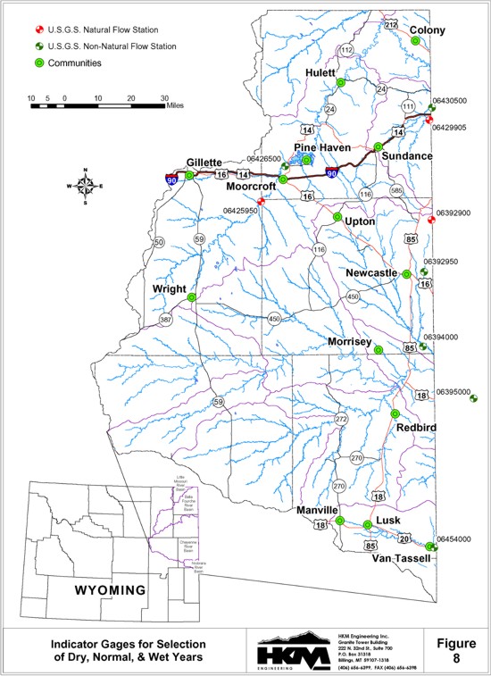
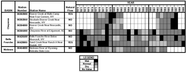
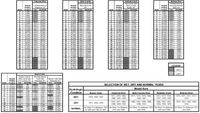
Water availability models are to be developed to represent dry year, normal year, and wet year hydrologic conditions throughout the Northeast Wyoming River Basins. To this end, the annual streamflows for the study period developed through the surface water hydrology work are ranked and divided into these three hydrologic categories. Indicator gages are selected for this purpose, to represent hydrologic conditions for the entire geographic area of the Northeast Wyoming River Basins. The seven indicator gages are shown on Figure 8. The years with non-exceedance probabilities of 20 percent or less (the driest 20 percent) were selected as dry years. Similarly, the years with exceedance probabilities of 20 percent or less (the wettest 20 percent) were selected as wet years. The remaining 60 percent of the years represent normal years. The dry years, normal years, and wet years for the indicator gages are illustrated on Figure 9. As can be seen, the hydrologic conditions from year to year vary from location to location (i.e. dry years, wet years, and normal years do not occur at all locations simultaneously). The dry, normal, and wet years selected to represent each drainage are, therefore unique to each geographic location. The years selected to represent dry, wet, and normal hydrologic conditions are summarized on Figure 10. According to the streamflow records for the Beaver Creek drainage, the hydrologic conditions vary significantly from location to location within the drainage. The wet years, dry years, and normal years for the Beaver Creek drainage are therefore, selected to best represent all locations concurrently.
FIGURE 9
WET, DRY AND AVERAGE YEARS FOR INDICATOR STATIONS
IN THE NORTHEAST WYOMING RIVER BASINS
click to enlarge
FIGURE 10
SELECTION OF WET, DRY, AND NORMAL YEARS FOR MODELING
Indicator Stations for the Northeast Wyoming River Basins
click to enlarge
The average monthly and annual streamflow for dry years, normal years, and wet years at the gaged model nodes are provided in Tables 8, 9, and 10 respectively.
TABLE 8
SUMMARY OF DRY YEAR MONTHLY AND ANNUAL FLOWS (1970 TO 1999 UNLESS OTHERWISE
NOTED)
AT GAGED MODEL NODES
| Basin | Station Number |
Station Name | Natural Flow |
Average Streamflow for 1970-1999 in Acre-Feet | Note | ||||||||||||
| Oct | Nov | Dec | Jan | Feb | Mar | Apr | May | Jun | Jul | Aug | Sep | Annual | |||||
| Cheyenne | 06364700 | Antelope Creek Near Teckla, WY | NO | 22 | 24 | 9 | 18 | 38 | 161 | 69 | 39 | 8 | 153 | 27 | 130 | 698 | |
| 06365300 | Dry Fork Cheyenne River Near Bill, WY | NO | 0 | 1 | 1 | 0 | 2 | 5 | 6 | 4 | 0 | 11 | 0 | 0 | 30 | ||
| 06365900 | Cheyenne River Near Dull Center, WY | NO | 33 | 13 | 14 | 30 | 73 | 324 | 128 | 114 | 82 | 447 | 217 | 103 | 1,577 | ||
| 06375600 | Little Thunder Chreek Near Hampshire, WY | NO | 0 | 0 | 0 | 0 | 0 | 3 | 0 | 3 | 1 | 10 | 1 | 0 | 19 | ||
| 06376300 | Black Thunder Creek Near Hampshire, WY | NO | 122 | 9 | 0 | 60 | 9 | 70 | 114 | 169 | 176 | 308 | 145 | 92 | 1,272 | ||
| 06378300 | Lodgepole Creek Near Hampshire, WY | NO | 0 | 0 | 0 | 0 | 0 | 5 | 4 | 26 | 11 | 4 | 4 | 0 | 54 | ||
| 06386000 | Lance Creek Near Riverview, WY | NO | 104 | 99 | 41 | 683 | 240 | 273 | 347 | 1,008 | 466 | 545 | 511 | 230 | 4,547 | ||
| 06386500 | Cheyenne River Near Spencer, WY | NO | 259 | 216 | 67 | 953 | 430 | 283 | 473 | 1,734 | 762 | 187 | 51 | 280 | 5,695 | ||
| 06392900 | Beaver Creek at Mallo Camp, Near Four Corners, WY | YES | 65 | 61 | 54 | 50 | 62 | 66 | 70 | 72 | 108 | 91 | 81 | 81 | 861 | Study Period: 1975-1982, 1992-1997 | |
| 06392950 | Stockade Beaver Creek Near Newcastle, WY | NO | 722 | 758 | 744 | 759 | 675 | 759 | 648 | 419 | 506 | 668 | 557 | 664 | 7,879 | Study Period: 1975-1982, 1992-1997 | |
| 06394000 | Beaver Creek Near Newcastle, WY | NO | 363 | 762 | 740 | 741 | 756 | 3,202 | 1,906 | 1,411 | 1,744 | 1,459 | 1,187 | 404 | 14,674 | Study Period: 1975-1982, 1992-1997 | |
| 06395000 | Cheyenne River at Edgemont, SD | NO | 743 | 893 | 430 | 632 | 1,264 | 4,005 | 1,571 | 1,081 | 664 | 1,148 | 511 | 1,871 | 14,811 | ||
| Belle Fourche | 06425720 | Belle Fourche River Below Rattlesnake Creek, Near Piney, WY | NO | 1 | 3 | 7 | 12 | 24 | 53 | 16 | 155 | 55 | 36 | 71 | 5 | 438 | |
| 06425780 | Belle Fourche River Above Dry Creek Near Piney, WY | NO | 5 | 2 | 6 | 13 | 51 | 128 | 29 | 284 | 56 | 146 | 69 | 13 | 802 | ||
| 06425900 | Caballo Creek at Mouth Near Piney, WY, WY | NO | 1 | 12 | 0 | 1 | 7 | 17 | 4 | 50 | 6 | 70 | 7 | 1 | 175 | ||
| 06425950 | Raven Creek Near Moorcroft, WY | YES | 0 | 0 | 0 | 0 | 7 | 3 | 0 | 1 | 0 | 0 | 8 | 0 | 20 | ||
| 06426400 | Donkey Creek Near Moorcroft, WY | NO | 4 | 12 | 23 | 17 | 31 | 156 | 29 | 186 | 15 | 3 | 3 | 3 | 481 | ||
| 06426500 | Belle Fourche River Below Moorcroft, WY | NO | 26 | 70 | 61 | 41 | 464 | 1,460 | 299 | 443 | 212 | 1,189 | 183 | 71 | 4,517 | ||
| USBR Gage | Belle Fourche River - Total Keyhole Reservoir Discharge | NO | 0 | 0 | 0 | 4 | 2 | 0 | 1,272 | 4,445 | 4,782 | 8,563 | 7,857 | 995 | 27,919 | ||
| 06427500 | Belle Fourche River Below Keyhole Reservoir, WY | NO | 106 | 99 | 101 | 105 | 96 | 100 | 1,362 | 4,476 | 4,872 | 8,172 | 7,803 | 1,102 | 28,394 | ||
| 06428200 | Belle Fourche River Near Alva, WY | NO | 763 | 990 | 748 | 372 | 565 | 3,225 | 2,160 | 4,088 | 3,941 | 5,745 | 6,394 | 2,123 | 31,114 | ||
| 06428500 | Belle Fourche River at Wyoming-South Dakota State Line | NO | 870 | 1,170 | 863 | 409 | 640 | 4,244 | 3,332 | 5,742 | 4,923 | 7,172 | 6,845 | 2,458 | 38,668 | ||
| 06429905 | Sand Creek Near Ranch A Near Beulah, WY | YES | 927 | 1,071 | 1,063 | 1,036 | 906 | 987 | 1,028 | 1,085 | 996 | 982 | 968 | 979 | 12,026 | ||
| 06430500 | Redwater Creek at Wyoming-South Dakota State Line, WY | NO | 1,465 | 1,615 | 1,582 | 1,543 | 1,398 | 1,642 | 1,665 | 1,700 | 1,671 | 1,441 | 1,538 | 1,577 | 18,836 | ||
| Niobrara | 06454000 | Niobrara River at Wyoming-Nebraska State Line, WY | NO | 118 | 130 | 134 | 131 | 138 | 210 | 180 | 185 | 142 | 115 | 115 | 117 | 1,716 | Study Period: 1970-1994 |
TABLE 9
SUMMARY OF NORMAL YEAR MONTHLY AND ANNUAL FLOWS (1970 TO 1999 UNLESS OTHERWISE
NOTED)
AT GAGED MODEL NODES
| Basin | Station Number |
Station Name | Natural Flow |
Average Streamflow for 1970-1999 in Acre-Feet | Note | ||||||||||||
| Oct | Nov | Dec | Jan | Feb | Mar | Apr | May | Jun | Jul | Aug | Sep | Annual | |||||
| Cheyenne | 06364700 | Antelope Creek Near Teckla, WY | NO | 69 | 27 | 19 | 21 | 199 | 658 | 302 | 516 | 531 | 268 | 179 | 94 | 2,882 | |
| 06365300 | Dry Fork Cheyenne River Near Bill, WY | NO | 2 | 5 | 5 | 2 | 14 | 30 | 16 | 93 | 20 | 14 | 8 | 0 | 209 | ||
| 06365900 | Cheyenne River Near Dull Center, WY | NO | 203 | 20 | 23 | 35 | 516 | 816 | 582 | 908 | 1,120 | 730 | 491 | 50 | 5,494 | ||
| 06375600 | Little Thunder Chreek Near Hampshire, WY | NO | 3 | 5 | 6 | 5 | 55 | 61 | 12 | 395 | 120 | 124 | 100 | 2 | 890 | ||
| 06376300 | Black Thunder Creek Near Hampshire, WY | NO | 317 | 17 | 0 | 27 | 200 | 647 | 286 | 1,051 | 699 | 370 | 378 | 335 | 4,326 | ||
| 06378300 | Lodgepole Creek Near Hampshire, WY | NO | 1 | 2 | 1 | 1 | 2 | 40 | 26 | 150 | 79 | 21 | 34 | 1 | 358 | ||
| 06386000 | Lance Creek Near Riverview, WY | NO | 115 | 110 | 93 | 201 | 1,040 | 956 | 754 | 2,998 | 2,471 | 2,998 | 2,280 | 802 | 14,809 | ||
| 06386500 | Cheyenne River Near Spencer, WY | NO | 186 | 159 | 48 | 695 | 1,196 | 748 | 1,534 | 14,793 | 6,889 | 1,938 | 511 | 3,325 | 32,023 | ||
| 06392900 | Beaver Creek at Mallo Camp, Near Four Corners, WY | YES | 114 | 102 | 106 | 95 | 95 | 113 | 142 | 154 | 141 | 129 | 122 | 111 | 1,421 | Study Period: 1975-1982, 1992-1997 | |
| 06392950 | Stockade Beaver Creek Near Newcastle, WY | NO | 723 | 713 | 762 | 723 | 694 | 827 | 746 | 600 | 642 | 628 | 658 | 686 | 8,400 | Study Period: 1975-1982, 1992-1997 | |
| 06394000 | Beaver Creek Near Newcastle, WY | NO | 520 | 763 | 846 | 815 | 1,610 | 5,867 | 1,840 | 4,151 | 2,177 | 1,597 | 850 | 403 | 21,439 | Study Period: 1975-1982, 1992-1997 | |
| 06395000 | Cheyenne River at Edgemont, SD | NO | 1,744 | 1,023 | 741 | 836 | 3,785 | 9,936 | 4,071 | 5,678 | 7,006 | 4,720 | 3,922 | 1,584 | 45,044 | ||
| Belle Fourche | 06425720 | Belle Fourche River Below Rattlesnake Creek, Near Piney, WY | NO | 7 | 6 | 11 | 24 | 86 | 179 | 61 | 449 | 246 | 93 | 150 | 22 | 1,334 | |
| 06425780 | Belle Fourche River Above Dry Creek Near Piney, WY | NO | 21 | 6 | 14 | 48 | 203 | 484 | 130 | 690 | 292 | 174 | 179 | 68 | 2,310 | ||
| 06425900 | Caballo Creek at Mouth Near Piney, WY, WY | NO | 13 | 7 | 1 | 11 | 27 | 183 | 30 | 487 | 58 | 81 | 40 | 13 | 951 | ||
| 06425950 | Raven Creek Near Moorcroft, WY | YES | 6 | 0 | 0 | 2 | 55 | 96 | 2 | 44 | 1 | 4 | 11 | 0 | 223 | ||
| 06426400 | Donkey Creek Near Moorcroft, WY | NO | 24 | 13 | 24 | 15 | 27 | 1,302 | 128 | 1,616 | 74 | 14 | 4 | 3 | 3,245 | ||
| 06426500 | Belle Fourche River Below Moorcroft, WY | NO | 846 | 276 | 205 | 494 | 1,513 | 3,406 | 2,128 | 2,920 | 1,675 | 804 | 418 | 376 | 15,059 | ||
| USBR Gage | Belle Fourche River - Total Keyhole Reservoir Discharge | NO | 191 | 533 | 0 | 0 | 0 | 8 | 629 | 380 | 1,340 | 4,723 | 4,080 | 623 | 12,507 | ||
| 06427500 | Belle Fourche River Below Keyhole Reservoir, WY | NO | 359 | 371 | 108 | 107 | 98 | 186 | 557 | 374 | 1,233 | 4,867 | 4,192 | 695 | 13,147 | ||
| 06428200 | Belle Fourche River Near Alva, WY | NO | 2,083 | 1,922 | 1,197 | 1,347 | 2,606 | 6,675 | 7,476 | 9,812 | 6,582 | 4,667 | 4,803 | 1,918 | 51,086 | ||
| 06428500 | Belle Fourche River at Wyoming-South Dakota State Line | NO | 2,652 | 2,471 | 1,445 | 1,656 | 3,488 | 9,328 | 10,601 | 15,628 | 10,124 | 5,983 | 5,235 | 2,267 | 70,878 | ||
| 06429905 | Sand Creek Near Ranch A Near Beulah, WY | YES | 1,343 | 1,290 | 1,274 | 1,227 | 1,096 | 1,236 | 1,266 | 1,998 | 1,772 | 1,494 | 1,445 | 1,329 | 16,772 | ||
| 06430500 | Redwater Creek at Wyoming-South Dakota State Line, WY | NO | 2,143 | 2,068 | 2,038 | 1,996 | 1,976 | 2,280 | 2,386 | 4,025 | 3,077 | 2,135 | 2,167 | 2,096 | 28,387 | ||
| Niobrara | 06454000 | Niobrara River at Wyoming-Nebraska State Line, WY | NO | 149 | 144 | 148 | 142 | 157 | 299 | 275 | 257 | 214 | 147 | 172 | 105 | 2,210 | Study Period: 1970-1994 |
TABLE 10
SUMMARY OF WET YEAR MONTHLY AND ANNUAL FLOWS (1970 TO 1999 UNLESS OTHERWISE
NOTED)
AT GAGED MODEL NODES
| Basin | Station Number |
Station Name | Natural Flow |
Average Streamflow for 1970-1999 in Acre-Feet | Note | ||||||||||||
| Oct | Nov | Dec | Jan | Feb | Mar | Apr | May | Jun | Jul | Aug | Sep | Annual | |||||
| Cheyenne | 06364700 | Antelope Creek Near Teckla, WY | NO | 258 | 217 | 28 | 28 | 162 | 588 | 482 | 6,013 | 3,421 | 848 | 176 | 52 | 12,273 | |
| 06365300 | Dry Fork Cheyenne River Near Bill, WY | NO | 7 | 13 | 11 | 7 | 43 | 126 | 44 | 687 | 124 | 97 | 14 | 1 | 1,174 | ||
| 06365900 | Cheyenne River Near Dull Center, WY | NO | 237 | 434 | 46 | 46 | 414 | 1,221 | 1,289 | 14,535 | 7,795 | 1,635 | 436 | 77 | 28,165 | ||
| 06375600 | Little Thunder Chreek Near Hampshire, WY | NO | 8 | 7 | 8 | 7 | 74 | 245 | 17 | 2,930 | 295 | 291 | 200 | 3 | 4,084 | ||
| 06376300 | Black Thunder Creek Near Hampshire, WY | NO | 464 | 20 | 0 | 115 | 752 | 2,218 | 569 | 5,615 | 1,081 | 1,324 | 748 | 1,391 | 14,298 | ||
| 06378300 | Lodgepole Creek Near Hampshire, WY | NO | 1 | 3 | 2 | 1 | 4 | 100 | 81 | 638 | 206 | 93 | 61 | 4 | 1,193 | ||
| 06386000 | Lance Creek Near Riverview, WY | NO | 215 | 128 | 97 | 379 | 990 | 2,883 | 1,898 | 17,967 | 5,708 | 5,456 | 3,037 | 835 | 39,593 | ||
| 06386500 | Cheyenne River Near Spencer, WY | NO | 559 | 474 | 144 | 2,078 | 3,418 | 1,800 | 5,123 | 54,135 | 25,000 | 4,514 | 1,091 | 7,012 | 105,348 | ||
| 06392900 | Beaver Creek at Mallo Camp, Near Four Corners, WY | YES | 126 | 122 | 114 | 120 | 123 | 147 | 166 | 148 | 167 | 166 | 138 | 117 | 1,655 | Study Period: 1975-1982, 1992-1997 | |
| 06392950 | Stockade Beaver Creek Near Newcastle, WY | NO | 789 | 770 | 771 | 780 | 739 | 1,075 | 918 | 787 | 689 | 760 | 884 | 865 | 9,827 | Study Period: 1975-1982, 1992-1997 | |
| 06394000 | Beaver Creek Near Newcastle, WY | NO | 715 | 924 | 829 | 972 | 5,219 | 8,927 | 3,837 | 4,062 | 2,113 | 1,339 | 1,321 | 474 | 30,731 | Study Period: 1975-1982, 1992-1997 | |
| 06395000 | Cheyenne River at Edgemont, SD | NO | 3,573 | 3,117 | 768 | 859 | 2,914 | 10,422 | 7,592 | 52,665 | 30,940 | 8,293 | 4,069 | 1,879 | 127,090 | ||
| Belle Fourche | 06425720 | Belle Fourche River Below Rattlesnake Creek, Near Piney, WY | NO | 9 | 9 | 17 | 34 | 115 | 470 | 130 | 1,926 | 386 | 189 | 224 | 30 | 3,540 | |
| 06425780 | Belle Fourche River Above Dry Creek Near Piney, WY | NO | 39 | 10 | 22 | 70 | 290 | 1,476 | 237 | 3,132 | 477 | 531 | 290 | 130 | 6,705 | ||
| 06425900 | Caballo Creek at Mouth Near Piney, WY, WY | NO | 26 | 18 | 1 | 17 | 47 | 538 | 55 | 2,429 | 204 | 182 | 100 | 51 | 3,667 | ||
| 06425950 | Raven Creek Near Moorcroft, WY | YES | 12 | 0 | 0 | 4 | 99 | 552 | 5 | 254 | 7 | 24 | 23 | 0 | 979 | ||
| 06426400 | Donkey Creek Near Moorcroft, WY | NO | 93 | 38 | 70 | 40 | 74 | 4,474 | 310 | 6,512 | 282 | 40 | 11 | 8 | 11,952 | ||
| 06426500 | Belle Fourche River Below Moorcroft, WY | NO | 850 | 118 | 70 | 577 | 3,802 | 11,643 | 4,656 | 16,641 | 5,432 | 1,384 | 1,138 | 208 | 46,519 | ||
| USBR Gage | Belle Fourche River - Total Keyhole Reservoir Discharge | NO | 0 | 0 | 0 | 0 | 0 | 4,378 | 759 | 5,162 | 3,206 | 1,374 | 2,531 | 943 | 18,353 | ||
| 06427500 | Belle Fourche River Below Keyhole Reservoir, WY | NO | 105 | 90 | 91 | 93 | 87 | 4,416 | 766 | 5,372 | 3,239 | 1,391 | 2,620 | 979 | 19,248 | ||
| 06428200 | Belle Fourche River Near Alva, WY | NO | 2,121 | 1,487 | 977 | 2,462 | 3,715 | 15,275 | 12,966 | 17,333 | 13,942 | 4,878 | 4,102 | 2,114 | 81,370 | ||
| 06428500 | Belle Fourche River at Wyoming-South Dakota State Line | NO | 2,709 | 1,827 | 1,162 | 3,329 | 5,058 | 22,710 | 17,625 | 25,247 | 25,372 | 7,413 | 4,458 | 2,423 | 119,333 | ||
| 06429905 | Sand Creek Near Ranch A Near Beulah, WY | YES | 1,602 | 1,597 | 1,539 | 1,468 | 1,263 | 1,460 | 1,617 | 2,326 | 2,566 | 2,031 | 2,094 | 1,704 | 21,266 | ||
| 06430500 | Redwater Creek at Wyoming-South Dakota State Line, WY | NO | 2,646 | 2,567 | 2,517 | 2,498 | 2,317 | 2,718 | 3,012 | 4,712 | 4,772 | 3,104 | 3,185 | 2,730 | 36,778 | ||
| Niobrara | 06454000 | Niobrara River at Wyoming-Nebraska State Line, WY | NO | 189 | 191 | 218 | 337 | 427 | 471 | 478 | 286 | 254 | 158 | 125 | 159 | 3,293 | Study Period: 1970-1994 |
The average monthly and annual streamflow for dry years, normal years, and wet years at the ungaged model nodes are provided in Tables 11, 12, and 13 respectively.
TABLE 11
SUMMARY OF DRY YEAR MONTHLY AND ANNUAL FLOWS
AT UNGAGED NATURAL FLOW NODES
| Basin | Station Name | Estimated Average Streamflow for 1970-1999 in Acre-Feet | ||||||||||||
| Oct | Nov | Dec | Jan | Feb | Mar | Apr | May | Jun | Jul | Aug | Sep | Annual | ||
| Cheyenne | Willow Creek at Mouth in Section 28, T38N, R72W | 1 | 0 | 0 | 0 | 7 | 22 | 0 | 10 | 0 | 1 | 28 | 0 | 43 |
| Woody Creek at Mouth in Section 5, T39N, R69W | 0 | 0 | 0 | 0 | 1 | 3 | 0 | 1 | 0 | 0 | 0 | 0 | 5 | |
| Lake Creek at Mouth in Section 30, T40N, R68W | 0 | 0 | 0 | 0 | 2 | 7 | 0 | 3 | 0 | 0 | 1 | 0 | 13 | |
| Sheep Creek at Mouth in Section 7, T40N, R67W | 0 | 0 | 0 | 0 | 1 | 2 | 0 | 1 | 0 | 0 | 0 | 0 | 4 | |
| Wagonhound Creek at Mouth in Section 31, T41N, R67W | 0 | 0 | 0 | 0 | 1 | 4 | 0 | 2 | 0 | 0 | 0 | 0 | 7 | |
| Snyder Creek at Mouth in Section 23, T40N, R64W | 1 | 0 | 0 | 0 | 7 | 21 | 0 | 9 | 0 | 1 | 2 | 0 | 41 | |
| Boggy Creek at Mouth in Section 32, T40N, R63W | 0 | 0 | 0 | 0 | 2 | 6 | 0 | 3 | 0 | 0 | 0 | 0 | 11 | |
| Sevenmile Creek at Mouth in Section 34, T40N, R63W | 0 | 0 | 0 | 0 | 1 | 3 | 0 | 1 | 0 | 0 | 0 | 0 | 5 | |
| Mule Creek at Mouth in Section 6, T39N, R61W | 0 | 0 | 0 | 0 | 3 | 9 | 0 | 4 | 0 | 0 | 1 | 0 | 17 | |
| Robbers' Roost Creek at Mouth in Section 23, T40N, R61W | 0 | 0 | 0 | 0 | 4 | 13 | 0 | 6 | 0 | 1 | 1 | 0 | 25 | |
| Beaver Creek Just Below Mush Creek in Section 32, T44N, R62W | 1 | 0 | 0 | 0 | 39 | 16 | 0 | 7 | 0 | 1 | 44 | 0 | 108 | |
| Oil Creek at Mouth in Section 26, T43N, R62W | 201 | 0 | 0 | 63 | 1,739 | 5,441 | 84 | 2,507 | 73 | 235 | 414 | 0 | 10,757 | |
| Blacktail Creek at Mouth in Section 2, T41N, R61W | 182 | 177 | 181 | 181 | 162 | 174 | 183 | 218 | 207 | 198 | 186 | 181 | 2,230 | |
| Dry Beaver Creek Just Above Beaver Creek in Section 4, T47N, R60W | 65 | 62 | 54 | 51 | 62 | 67 | 71 | 73 | 109 | 92 | 81 | 82 | 869 | |
| Belle Fourche | Dry Creek at Mouth in Section 29, T47N, R70W | 0 | 0 | 0 | 0 | 2 | 1 | 0 | 0 | 0 | 0 | 2 | 0 | 5 |
| Yellow Hammer Creek at Mouth in Section 10, T47N, R70W | 0 | 0 | 0 | 0 | 1 | 0 | 0 | 0 | 0 | 0 | 1 | 0 | 2 | |
| Whitetail Creek at Mouth in Section 32, T48N, R69W | 0 | 0 | 0 | 0 | 1 | 0 | 0 | 0 | 0 | 0 | 1 | 0 | 2 | |
| Four Horse Creek at Mouth in Section 11, T48N, R69W | 0 | 0 | 0 | 0 | 10 | 4 | 0 | 2 | 0 | 0 | 11 | 0 | 27 | |
| Timber Creek at Mouth in Section 2, T48N, R69W | 0 | 0 | 0 | 0 | 3 | 1 | 0 | 0 | 0 | 0 | 3 | 0 | 7 | |
| Buffalo Creek at Mouth in Section 14, T49N, R68W | 0 | 0 | 0 | 0 | 12 | 5 | 0 | 2 | 0 | 0 | 14 | 0 | 33 | |
| Donkey Creek Just Upsteam of Gage in Sec. 30, T50N, R68W | 0 | 0 | 0 | 902 | 1,400 | 1,658 | 1,367 | 1,176 | 676 | 0 | 0 | 0 | 7,179 | |
| Trail Creek at Mouth in Section 24, T50N, R68W | 0 | 0 | 0 | 0 | 1 | 1 | 0 | 0 | 0 | 0 | 2 | 0 | 4 | |
| Dry Creek at Mouth in Section 24, T50N, R68W | 0 | 0 | 0 | 0 | 2 | 1 | 0 | 0 | 0 | 0 | 2 | 0 | 5 | |
| Robinson Creek at Mouth in Section 18, T50N, R67W | 0 | 0 | 0 | 0 | 1 | 0 | 0 | 0 | 0 | 0 | 1 | 0 | 2 | |
| Duck Creek at Mouth in Section 8, T50N, R67W | 1 | 0 | 0 | 0 | 47 | 18 | 0 | 8 | 0 | 1 | 36 | 0 | 111 | |
| Miller Creek at Mouth in Section 9, T50N, R67W | 7 | 0 | 0 | 2 | 532 | 200 | 3 | 91 | 3 | 9 | 409 | 0 | 1,256 | |
| Smoke Creek at Mouth in Section 9, T50N, R67W | 0 | 0 | 0 | 0 | 14 | 5 | 0 | 2 | 0 | 0 | 11 | 0 | 32 | |
| Berger Creek at Mouth in Section 12, T50N, R67W | 0 | 0 | 0 | 0 | 22 | 8 | 0 | 4 | 0 | 0 | 17 | 0 | 51 | |
| Lone Tree Creek at Mouth in Section 26, T51N, R67W | 1 | 0 | 0 | 0 | 49 | 18 | 0 | 8 | 0 | 1 | 38 | 0 | 115 | |
| Wind Creek at Mouth in Section 13, T50N, R67W | 17 | 0 | 0 | 5 | 1,218 | 458 | 7 | 208 | 6 | 21 | 935 | 0 | 2,875 | |
| Deer Creek at Mouth in Section 23, T51N, R67W | 4 | 0 | 0 | 1 | 257 | 97 | 1 | 44 | 1 | 5 | 198 | 0 | 608 | |
| Eggie Creek at Mouth in Section 21, T51N, R66W | 0 | 0 | 0 | 0 | 36 | 13 | 0 | 6 | 0 | 1 | 27 | 0 | 83 | |
| Mule Creek at Mouth in Section 15, T50N, R66W | 2 | 0 | 0 | 1 | 156 | 59 | 1 | 27 | 1 | 3 | 120 | 0 | 370 | |
| Cottonwood Creek at Mouth in Section 35, T51N, R66W | 1 | 0 | 0 | 0 | 41 | 16 | 0 | 7 | 0 | 1 | 32 | 0 | 98 | |
| Arch Creek at Mouth in Section 11, T51N, R66W | 0 | 0 | 0 | 0 | 8 | 3 | 0 | 2 | 0 | 0 | 9 | 0 | 22 | |
| Inyan Kara Creek at Mouth in Section 25, T52N, R66W | 919 | 1,051 | 1,068 | 1,017 | 884 | 960 | 963 | 1,061 | 939 | 894 | 896 | 943 | 11,595 | |
| Cabin Creek at Mouth in Section 14, T52N, R66W | 0 | 0 | 0 | 0 | 6 | 2 | 0 | 1 | 0 | 0 | 7 | 0 | 16 | |
| Miller Creek at Mouth in Section 12, T52N, R66W | 0 | 0 | 0 | 0 | 5 | 2 | 0 | 1 | 0 | 0 | 6 | 0 | 14 | |
| Lytle Creek at Mouth in Section 8, T53N, R65W | 0 | 0 | 0 | 0 | 4 | 1 | 0 | 1 | 0 | 0 | 4 | 0 | 10 | |
| Whitetail Creek at Mouth in Section 14, T54N, R65W | 66 | 76 | 77 | 73 | 63 | 69 | 69 | 76 | 68 | 64 | 64 | 68 | 833 | |
| Blacktail Creek at Mouth in Section 12, T54N, R65W | 168 | 193 | 196 | 186 | 160 | 175 | 176 | 194 | 172 | 164 | 162 | 173 | 2,119 | |
| Beaver Creek at Mouth in Section 1, T55N, R64W | 368 | 421 | 428 | 407 | 350 | 383 | 386 | 424 | 376 | 358 | 354 | 378 | 4,633 | |
| East Creek at Mouth in Section 32, T55N, R63W | 38 | 44 | 45 | 42 | 36 | 40 | 40 | 44 | 39 | 37 | 37 | 39 | 481 | |
| Arnold Creek at Mouth in Section 28, T55N, R63W | 18 | 20 | 21 | 20 | 17 | 19 | 19 | 21 | 18 | 17 | 17 | 18 | 225 | |
| Horse Creek at Mouth in Section 19, T56N, R61W | 61 | 69 | 71 | 67 | 58 | 63 | 64 | 70 | 62 | 59 | 58 | 62 | 764 | |
| Pine Creek at Mouth in Section 33, T56N, R61W | 138 | 158 | 160 | 153 | 131 | 143 | 145 | 159 | 141 | 134 | 133 | 142 | 1,737 | |
| Kilpatrick Creek at Mouth in Section 3, T55N, R61W | 56 | 64 | 65 | 61 | 53 | 58 | 58 | 64 | 57 | 54 | 54 | 57 | 701 | |
| Kruger Creek at Mouth in Section 11, T55N, R61W | 27 | 31 | 31 | 30 | 26 | 28 | 28 | 31 | 28 | 26 | 26 | 28 | 340 | |
| Oak Creek at Mouth in Section 20, T55N, R60W | 173 | 198 | 201 | 191 | 165 | 180 | 181 | 199 | 177 | 168 | 167 | 178 | 2,178 | |
| South Redwater Creek Just Above Sand Creek in Section 31, T53N, R60W | 399 | 461 | 458 | 446 | 390 | 425 | 443 | 467 | 429 | 423 | 417 | 422 | 5,180 | |
| Redwater Creek Just Above South Redwater Creek in Section 31, T53N, R60W | 203 | 234 | 232 | 227 | 198 | 216 | 225 | 237 | 218 | 215 | 212 | 214 | 2,631 | |
TABLE 12
SUMMARY OF NORMAL YEAR MONTHLY AND ANNUAL FLOWS
AT UNGAGED NATURAL FLOW NODES
| Basin | Station Name | Estimated Average Streamflow for 1970-1999 in Acre-Feet | ||||||||||||
| Oct | Nov | Dec | Jan | Feb | Mar | Apr | May | Jun | Jul | Aug | Sep | Annual | ||
| Cheyenne | Willow Creek at Mouth in Section 28, T38N, R72W | 11 | 0 | 0 | 4 | 97 | 188 | 4 | 87 | 3 | 8 | 23 | 0 | 425 |
| Woody Creek at Mouth in Section 5, T39N, R69W | 1 | 0 | 0 | 0 | 13 | 25 | 1 | 11 | 0 | 1 | 3 | 0 | 55 | |
| Lake Creek at Mouth in Section 30, T40N, R68W | 3 | 0 | 0 | 1 | 29 | 57 | 1 | 26 | 1 | 2 | 7 | 0 | 127 | |
| Sheep Creek at Mouth in Section 7, T40N, R67W | 1 | 0 | 0 | 0 | 9 | 18 | 0 | 8 | 0 | 1 | 2 | 0 | 39 | |
| Wagonhound Creek at Mouth in Section 31, T41N, R67W | 2 | 0 | 0 | 1 | 20 | 38 | 1 | 18 | 1 | 2 | 5 | 0 | 88 | |
| Snyder Creek at Mouth in Section 23, T40N, R64W | 10 | 0 | 0 | 3 | 91 | 177 | 4 | 82 | 2 | 8 | 22 | 0 | 399 | |
| Boggy Creek at Mouth in Section 32, T40N, R63W | 3 | 0 | 0 | 1 | 25 | 48 | 1 | 22 | 1 | 2 | 6 | 0 | 109 | |
| Sevenmile Creek at Mouth in Section 34, T40N, R63W | 1 | 0 | 0 | 0 | 12 | 24 | 1 | 11 | 0 | 1 | 3 | 0 | 53 | |
| Mule Creek at Mouth in Section 30, T39N, R61W | 4 | 0 | 0 | 1 | 39 | 76 | 2 | 35 | 1 | 3 | 9 | 0 | 170 | |
| Robbers' Roost Creek at Mouth in Section 23, T40N, R61W | 6 | 0 | 0 | 2 | 55 | 108 | 2 | 50 | 1 | 5 | 13 | 0 | 242 | |
| Beaver Creek Just Below Mush Creek in Section 32, T44N, R62W | 35 | 0 | 0 | 11 | 299 | 526 | 14 | 243 | 7 | 23 | 60 | 0 | 1,218 | |
| Oil Creek at Mouth in Section 26, T43N, R62W | 402 | 0 | 0 | 49 | 5,048 | 5,977 | 70 | 2,767 | 83 | 261 | 1,971 | 0 | 16,628 | |
| Blacktail Creek at Mouth in Section 2, T41N, R61W | 199 | 196 | 190 | 180 | 156 | 179 | 187 | 324 | 274 | 244 | 218 | 200 | 2,547 | |
| Dry Beaver Creek at Mouth in Section 4, T47N, R60W | 115 | 103 | 107 | 96 | 96 | 114 | 143 | 155 | 142 | 130 | 124 | 112 | 1,437 | |
| Belle Fourche | Dry Creek at Mouth in Section 29, T47N, R70W | 2 | 0 | 0 | 1 | 14 | 25 | 1 | 11 | 0 | 1 | 3 | 0 | 58 |
| Yellow Hammer Creek at Mouth in Section 10, T47N, R70W | 1 | 0 | 0 | 0 | 5 | 9 | 0 | 4 | 0 | 0 | 1 | 0 | 20 | |
| Whitetail Creek at Mouth in Section 32, T48N, R69W | 1 | 0 | 0 | 0 | 8 | 14 | 0 | 6 | 0 | 1 | 2 | 0 | 32 | |
| Four Horse Creek at Mouth in Section 11, T48N, R69W | 9 | 0 | 0 | 3 | 74 | 130 | 3 | 60 | 2 | 6 | 15 | 0 | 302 | |
| Timber Creek at Mouth in Section 2, T48N, R69W | 2 | 0 | 0 | 1 | 19 | 34 | 1 | 16 | 0 | 1 | 4 | 0 | 78 | |
| Buffalo Creek at Mouth in Section 14, T49N, R68W | 11 | 0 | 0 | 4 | 94 | 165 | 4 | 76 | 2 | 7 | 19 | 0 | 382 | |
| Donkey Creek Just Upsteam of Gage in Sec. 30, T50N, R68W | 0 | 0 | 0 | 235 | 1,126 | 2,518 | 1,451 | 2,883 | 886 | 0 | 0 | 0 | 9,100 | |
| Trail Creek at Mouth in Section 24, T50N, R68W | 1 | 0 | 0 | 0 | 10 | 18 | 0 | 9 | 0 | 1 | 2 | 0 | 41 | |
| Dry Creek at Mouth in Section 24, T50N, R68W | 2 | 0 | 0 | 1 | 15 | 26 | 1 | 12 | 0 | 1 | 3 | 0 | 61 | |
| Robinson Creek at Mouth in Section 18, T50N, R67W | 1 | 0 | 0 | 0 | 4 | 8 | 0 | 4 | 0 | 0 | 1 | 0 | 18 | |
| Duck Creek at Mouth in Section 8, T50N, R67W | 6 | 0 | 0 | 5 | 60 | 116 | 5 | 53 | 2 | 5 | 21 | 0 | 273 | |
| Miller Creek at Mouth in Section 9, T50N, R67W | 68 | 0 | 0 | 55 | 689 | 1,322 | 58 | 607 | 18 | 57 | 236 | 0 | 3,110 | |
| Smoke Creek at Mouth in Section 9, T50N, R67W | 2 | 0 | 0 | 1 | 18 | 34 | 1 | 16 | 0 | 1 | 6 | 0 | 79 | |
| Berger Creek at Mouth in Section 12, T50N, R67W | 3 | 0 | 0 | 2 | 29 | 56 | 2 | 26 | 1 | 2 | 10 | 0 | 131 | |
| Lone Tree Creek at Mouth in Section 26, T51N, R67W | 6 | 0 | 0 | 5 | 63 | 121 | 5 | 56 | 2 | 5 | 22 | 0 | 285 | |
| Wind Creek at Mouth in Section 13, T50N, R67W | 156 | 0 | 0 | 126 | 1,578 | 3,025 | 133 | 1,389 | 41 | 130 | 540 | 0 | 7,118 | |
| Deer Creek at Mouth in Section 23, T51N, R67W | 33 | 0 | 0 | 27 | 333 | 639 | 28 | 293 | 9 | 27 | 114 | 0 | 1,503 | |
| Eggie Creek at Mouth in Section 21, T51N, R66W | 5 | 0 | 0 | 4 | 46 | 88 | 4 | 41 | 1 | 4 | 16 | 0 | 209 | |
| Mule Creek at Mouth in Section 15, T50N, R66W | 20 | 0 | 0 | 16 | 202 | 387 | 17 | 178 | 5 | 17 | 69 | 0 | 911 | |
| Cottonwood Creek at Mouth in Section 35, T51N, R66W | 5 | 0 | 0 | 4 | 54 | 103 | 5 | 47 | 1 | 4 | 18 | 0 | 241 | |
| Arch Creek at Mouth in Section 11, T51N, R66W | 8 | 0 | 0 | 2 | 63 | 111 | 3 | 51 | 2 | 5 | 13 | 0 | 258 | |
| Inyan Kara Creek at Mouth in Section 25, T52N, R66W | 1,199 | 1,143 | 1,138 | 1,116 | 1,037 | 1,231 | 1,146 | 1,820 | 1,641 | 1,397 | 1,401 | 1,207 | 15,476 | |
| Cabin Creek at Mouth in Section 14, T52N, R66W | 6 | 0 | 0 | 2 | 48 | 84 | 2 | 39 | 1 | 4 | 10 | 0 | 196 | |
| Miller Creek at Mouth in Section 12, T52N, R66W | 5 | 0 | 0 | 1 | 40 | 70 | 2 | 32 | 1 | 3 | 8 | 0 | 162 | |
| Lytle Creek at Mouth in Section 8, T53N, R65W | 3 | 0 | 0 | 1 | 27 | 48 | 1 | 22 | 1 | 2 | 5 | 0 | 110 | |
| Whitetail Creek at Mouth in Section 14, T54N, R65W | 86 | 82 | 82 | 80 | 69 | 79 | 82 | 127 | 118 | 100 | 100 | 87 | 1,092 | |
| Blacktail Creek at Mouth in Section 12, T54N, R65W | 218 | 209 | 208 | 204 | 176 | 201 | 209 | 322 | 300 | 255 | 254 | 221 | 2,777 | |
| Beaver Creek at Mouth in Section 1, T55N, R64W | 477 | 458 | 456 | 446 | 385 | 439 | 458 | 704 | 657 | 557 | 555 | 483 | 6,075 | |
| East Creek at Mouth in Section 32, T55N, R63W | 50 | 48 | 47 | 46 | 40 | 46 | 48 | 73 | 68 | 58 | 58 | 50 | 632 | |
| Arnold Creek at Mouth in Section 28, T55N, R63W | 23 | 22 | 22 | 22 | 19 | 21 | 22 | 34 | 32 | 27 | 27 | 23 | 294 | |
| Horse Creek at Mouth in Section 19, T56N, R61W | 79 | 76 | 75 | 74 | 63 | 72 | 75 | 116 | 108 | 92 | 92 | 80 | 1,002 | |
| Pine Creek at Mouth in Section 33, T56N, R61W | 179 | 172 | 171 | 167 | 144 | 165 | 172 | 264 | 246 | 209 | 208 | 181 | 2,278 | |
| Kilpatrick Creek at Mouth in Section 3, T55N, R61W | 72 | 69 | 69 | 67 | 58 | 66 | 69 | 106 | 99 | 84 | 84 | 73 | 916 | |
| Kruger Creek at Mouth in Section 11, T55N, R61W | 35 | 34 | 33 | 33 | 28 | 32 | 34 | 52 | 48 | 41 | 41 | 36 | 447 | |
| Oak Creek at Mouth in Section 20, T55N, R60W | 224 | 215 | 214 | 210 | 181 | 207 | 215 | 331 | 309 | 262 | 261 | 227 | 2,856 | |
| South Redwater Creek Just Above Sand Creek in Section 31, T53N, R60W | 579 | 556 | 549 | 529 | 472 | 533 | 545 | 860 | 763 | 644 | 623 | 572 | 7,225 | |
| Redwater Creek Just Below South Redwater Creek in Section 31, T53N, R60W | 294 | 282 | 279 | 268 | 240 | 270 | 277 | 437 | 388 | 327 | 316 | 291 | 3,669 | |
TABLE 13
SUMMARY OF WET YEAR MONTHLY AND ANNUAL FLOWS
AT UNGAGED NATURAL FLOW NODES
| Basin | Station Name | Estimated Average Streamflow for 1970-1999 in Acre-Feet | ||||||||||||
| Oct | Nov | Dec | Jan | Feb | Mar | Apr | May | Jun | Jul | Aug | Sep | Annual | ||
| Cheyenne | Willow Creek at Mouth in Section 28, T38N, R72W | 10 | 0 | 0 | 3 | 83 | 601 | 5 | 276 | 8 | 26 | 20 | 0 | 1,032 |
| Woody Creek at Mouth in Section 5, T39N, R69W | 1 | 0 | 0 | 0 | 11 | 79 | 1 | 36 | 1 | 3 | 3 | 0 | 135 | |
| Lake Creek at Mouth in Section 30, T40N, R68W | 3 | 0 | 0 | 1 | 25 | 182 | 2 | 84 | 2 | 8 | 6 | 0 | 313 | |
| Sheep Creek at Mouth in Section 7, T40N, R67W | 1 | 0 | 0 | 0 | 8 | 58 | 0 | 27 | 1 | 2 | 2 | 0 | 99 | |
| Wagonhound Creek at Mouth in Section 31, T41N, R67W | 2 | 0 | 0 | 1 | 17 | 121 | 1 | 56 | 2 | 5 | 4 | 0 | 209 | |
| Snyder Creek at Mouth in Section 23, T40N, R64W | 9 | 0 | 0 | 3 | 77 | 563 | 5 | 259 | 7 | 24 | 18 | 0 | 965 | |
| Boggy Creek at Mouth in Section 32, T40N, R63W | 3 | 0 | 0 | 1 | 21 | 154 | 1 | 71 | 2 | 7 | 5 | 0 | 265 | |
| Sevenmile Creek at Mouth in Section 34, T40N, R63W | 1 | 0 | 0 | 0 | 10 | 75 | 1 | 35 | 1 | 3 | 2 | 0 | 128 | |
| Mule Creek at Mouth in Section 6, T39N, R61W | 4 | 0 | 0 | 1 | 33 | 242 | 2 | 111 | 3 | 10 | 8 | 0 | 414 | |
| Robbers' Roost Creek at Mouth in Section 23, T40N, R61W | 6 | 0 | 0 | 2 | 47 | 343 | 3 | 158 | 5 | 15 | 11 | 0 | 590 | |
| Beaver Creek Just Below Mush Creek in Section 32, T44N, R62W | 63 | 0 | 0 | 20 | 539 | 3,018 | 30 | 1,388 | 40 | 130 | 128 | 0 | 5,356 | |
| Oil Creek at Mouth in Section 26, T43N, R62W | 225 | 0 | 0 | 71 | 1,950 | 6,374 | 1,364 | 2,810 | 82 | 263 | 4,838 | 0 | 17,977 | |
| Blacktail Creek at Mouth in Section 2, T41N, R61W | 220 | 211 | 211 | 204 | 182 | 226 | 210 | 283 | 282 | 272 | 239 | 211 | 2,751 | |
| Dry Beaver Creek Just Above Beaver Creek in Section 4, T47N, R60W | 127 | 124 | 115 | 122 | 125 | 148 | 168 | 149 | 169 | 168 | 139 | 118 | 1,672 | |
| Belle Fourche | Dry Creek at Mouth in Section 29, T47N, R70W | 3 | 0 | 0 | 1 | 25 | 142 | 1 | 65 | 2 | 6 | 6 | 0 | 251 |
| Yellow Hammer Creek at Mouth in Section 10, T47N, R70W | 1 | 0 | 0 | 0 | 9 | 53 | 1 | 24 | 1 | 2 | 2 | 0 | 93 | |
| Whitetail Creek at Mouth in Section 32, T48N, R69W | 2 | 0 | 0 | 1 | 14 | 78 | 1 | 36 | 1 | 3 | 3 | 0 | 139 | |
| Four Horse Creek at Mouth in Section 11, T48N, R69W | 16 | 0 | 0 | 5 | 133 | 746 | 7 | 343 | 10 | 32 | 32 | 0 | 1,324 | |
| Timber Creek at Mouth in Section 2, T48N, R69W | 4 | 0 | 0 | 1 | 35 | 195 | 2 | 90 | 3 | 8 | 8 | 0 | 346 | |
| Buffalo Creek at Mouth in Section 14, T49N, R68W | 20 | 0 | 0 | 6 | 169 | 947 | 9 | 436 | 13 | 41 | 40 | 0 | 1,681 | |
| Donkey Creek Just Upsteam of Gage in Sec. 30, T50N, R68W | 0 | 0 | 0 | 102 | 879 | 5,657 | 1,848 | 7,956 | 1,275 | 0 | 0 | 0 | 17,717 | |
| Trail Creek at Mouth in Section 24, T50N, R68W | 2 | 0 | 0 | 1 | 19 | 106 | 1 | 49 | 1 | 5 | 5 | 0 | 189 | |
| Dry Creek at Mouth in Section 24, T50N, R68W | 3 | 0 | 0 | 1 | 26 | 148 | 1 | 68 | 2 | 6 | 6 | 0 | 261 | |
| Robinson Creek at Mouth in Section 18, T50N, R67W | 1 | 0 | 0 | 0 | 8 | 45 | 0 | 21 | 1 | 2 | 2 | 0 | 80 | |
| Duck Creek at Mouth in Section 8, T50N, R67W | 4 | 0 | 0 | 1 | 37 | 153 | 2 | 71 | 2 | 7 | 9 | 0 | 286 | |
| Miller Creek at Mouth in Section 9, T50N, R67W | 49 | 0 | 0 | 15 | 425 | 1,750 | 22 | 805 | 23 | 75 | 101 | 0 | 3,265 | |
| Smoke Creek at Mouth in Section 9, T50N, R67W | 1 | 0 | 0 | 0 | 11 | 45 | 1 | 21 | 1 | 2 | 3 | 0 | 85 | |
| Berger Creek at Mouth in Section 12, T50N, R67W | 2 | 0 | 0 | 1 | 18 | 74 | 1 | 34 | 1 | 3 | 4 | 0 | 138 | |
| Lone Tree Creek at Mouth in Section 26, T51N, R67W | 5 | 0 | 0 | 1 | 39 | 161 | 2 | 74 | 2 | 7 | 9 | 0 | 300 | |
| Wind Creek at Mouth in Section 13, T50N, R67W | 113 | 0 | 0 | 35 | 973 | 4,004 | 50 | 1,843 | 53 | 173 | 232 | 0 | 7,476 | |
| Deer Creek at Mouth in Section 23, T51N, R67W | 24 | 0 | 0 | 7 | 206 | 846 | 11 | 389 | 11 | 36 | 49 | 0 | 1,579 | |
| Eggie Creek at Mouth in Section 21, T51N, R66W | 3 | 0 | 0 | 1 | 28 | 117 | 1 | 54 | 2 | 5 | 7 | 0 | 218 | |
| Mule Creek at Mouth in Section 15, T50N, R66W | 14 | 0 | 0 | 5 | 125 | 512 | 6 | 236 | 7 | 22 | 30 | 0 | 957 | |
| Cottonwood Creek at Mouth in Section 35, T51N, R66W | 4 | 0 | 0 | 1 | 33 | 136 | 2 | 63 | 2 | 6 | 8 | 0 | 255 | |
| Arch Creek at Mouth in Section 11, T51N, R66W | 13 | 0 | 0 | 4 | 114 | 639 | 6 | 294 | 8 | 28 | 27 | 0 | 1,133 | |
| Inyan Kara Creek at Mouth in Section 25, T52N, R66W | 1,255 | 1,227 | 1,126 | 1,049 | 1,145 | 1,900 | 1,242 | 2,233 | 1,905 | 1,511 | 1,448 | 1,259 | 17,300 | |
| Cabin Creek at Mouth in Section 14, T52N, R66W | 10 | 0 | 0 | 3 | 86 | 483 | 5 | 222 | 6 | 21 | 21 | 0 | 857 | |
| Miller Creek at Mouth in Section 12, T52N, R66W | 8 | 0 | 0 | 3 | 71 | 399 | 4 | 184 | 5 | 17 | 17 | 0 | 708 | |
| Lytle Creek at Mouth in Section 8, T53N, R65W | 6 | 0 | 0 | 2 | 49 | 276 | 3 | 127 | 4 | 12 | 12 | 0 | 491 | |
| Whitetail Creek at Mouth in Section 14, T54N, R65W | 89 | 88 | 81 | 75 | 73 | 81 | 89 | 135 | 137 | 107 | 102 | 91 | 1,148 | |
| Blacktail Creek at Mouth in Section 12, T54N, R65W | 227 | 225 | 206 | 191 | 185 | 207 | 226 | 344 | 347 | 271 | 259 | 231 | 2,919 | |
| Beaver Creek at Mouth in Section 1, T55N, R64W | 496 | 491 | 451 | 418 | 404 | 452 | 495 | 753 | 759 | 592 | 567 | 505 | 6,383 | |
| East Creek at Mouth in Section 32, T55N, R63W | 52 | 51 | 47 | 44 | 42 | 47 | 51 | 78 | 79 | 62 | 59 | 53 | 665 | |
| Arnold Creek at Mouth in Section 28, T55N, R63W | 24 | 24 | 22 | 20 | 20 | 22 | 24 | 36 | 37 | 29 | 27 | 24 | 309 | |
| Horse Creek at Mouth in Section 19, T56N, R61W | 82 | 81 | 74 | 69 | 67 | 75 | 82 | 124 | 125 | 98 | 94 | 83 | 1,054 | |
| Pine Creek at Mouth in Section 33, T56N, R61W | 186 | 184 | 169 | 157 | 151 | 169 | 185 | 282 | 285 | 222 | 213 | 189 | 2,392 | |
| Kilpatrick Creek at Mouth in Section 3, T55N, R61W | 75 | 74 | 68 | 63 | 61 | 68 | 75 | 114 | 115 | 89 | 86 | 76 | 964 | |
| Kruger Creek at Mouth in Section 11, T55N, R61W | 36 | 36 | 33 | 31 | 30 | 33 | 36 | 55 | 56 | 43 | 42 | 37 | 468 | |
| Oak Creek at Mouth in Section 20, T55N, R60W | 233 | 231 | 212 | 197 | 190 | 213 | 232 | 354 | 357 | 278 | 267 | 237 | 3,001 | |
| South Redwater Creek Just Above Sand Creek in Section 31, T53N, R60W | 690 | 688 | 663 | 632 | 544 | 629 | 697 | 1,002 | 1,105 | 875 | 902 | 734 | 9,161 | |
| Redwater Creek Just Below South Redwater Creek in Section 31, T53N, R60W | 350 | 349 | 337 | 321 | 276 | 319 | 354 | 509 | 561 | 444 | 458 | 373 | 4,651 | |
REFERENCES
Alley, William M and Burns, Alan W. "Mixed-Station Extension of Monthly Streamflow Records", American Society of Civil Engineers, Journal of Hydraulic Engineering, Vol. 109, No. 10, October 1983
Devore, Jay L., "Probability and Statistics for Engineering and the Sciences", Brooks/Cole Publishing Company. Belmont, California, 1987