Wyoming State Water Plan
Wyoming State Water Plan
Wyoming Water Development Office
6920 Yellowtail Rd
Cheyenne, WY 82002
Phone: 307-777-7626

Wyoming Water Development Office
6920 Yellowtail Rd
Cheyenne, WY 82002
Phone: 307-777-7626


Wind/Bighorn River Basin Water Plan Update
Groundwater Study Level I (2008-2011)
The 2012 Available Groundwater Determination Technical Memorandum is listed in the table below. The memorandum may be viewed in either HTML or PDF format. It is recommended that users download the latest version of Adobe Acrobat® Reader. If you do not already have this program on your computer, please visit Adobe's Website to dowload a free copy.
For information on the Wind/Bighorn River Basin Groundwater from the Wyoming State Geological Survey click here.
| Section | |
|---|---|
| 26,481 kb | Complete Report |
| 997 kb | Title page and Table of Contents |
| 968 kb | Chapter 1: Introduction |
| 84 kb | Chapter 2: Background |
| 1,521 kb | Chapter 3: Description of the Study Area |
| 654 kb | Chapter 4: Geologic Setting |
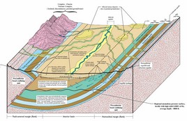
| 5,005 kb | Chapter 5: Technical Concepts: Hydrogeology and Groundwater Quality |
| 3,860 kb | Chapter 6: WBRB Hydrogeology and Groundwater Resources |
| 5,789 kb | Chapter 7: Hydrogeologic Units - Physical and Chemical Characteristics |
| 7,054 kb | Chapter 8: Groundwater Development and Use |
| 88 kb | Chapter 9: Looking to the Future |
| 1,638 kb | Appendices |
| 163 kb | References |
| Plate | |
| 6,302 kb | Plate I: Surface Geology |
| 203 kb | Plate II: Relation of lithostratigraphic units to hydrogeologic units |
| 214 kb | Plate III: Relation of lithostratigraphic units to hydrogeologic units |
| 5,132 kb | Plate IV: Surface Hydrogeology |
| 354 kb | Plate V: Geologic units - Lithostratigraphic units - Hydrogeologic units |
| 13,799 kb | Plate VI: Geologic cross sections |
| 2,028 kb | Plate VII: Isopach Maps of Selected Aquifers |
| 2,330 kb | Plate VIII: Isopach Maps of Selected Aquifers |
| 270 kb | Plate IX: Summaries of well yield, spring discharge, and hydraulic properties, Wind River and Bighorn Basins, Absaroka Range and Yellowstone volcanic area, WY |
| 5,229 kb | Plate X: Surface Hydrogeology with WSEO Permitted and Completed Wells |
| 0 kb | Plate XI: none |
| 920 kb | Plate XII: Predevelopment potentiometric surface of the Tensleep aquifer in the Bighorn Basin |
| 1,823 kb | Plate XIII: Potentiometric surface of the upper part of the Paleozoic aquifer system |
| 1,111 kb | Plate XIV: Potentiometric surface of the Madison-Bighorn aquifer in the northeastern Bighorn Basin |
| 1,372 kb | Plate XV: Potentiometric surface of the Madison-Bighorn aquifer, Ten Sleep area of the Bighorn Basin |