Wyoming State Water Plan
Wyoming State Water Plan
Wyoming Water Development Office
6920 Yellowtail Rd
Cheyenne, WY 82002
Phone: 307-777-7626

Wyoming Water Development Office
6920 Yellowtail Rd
Cheyenne, WY 82002
Phone: 307-777-7626


| SUBJECT: |
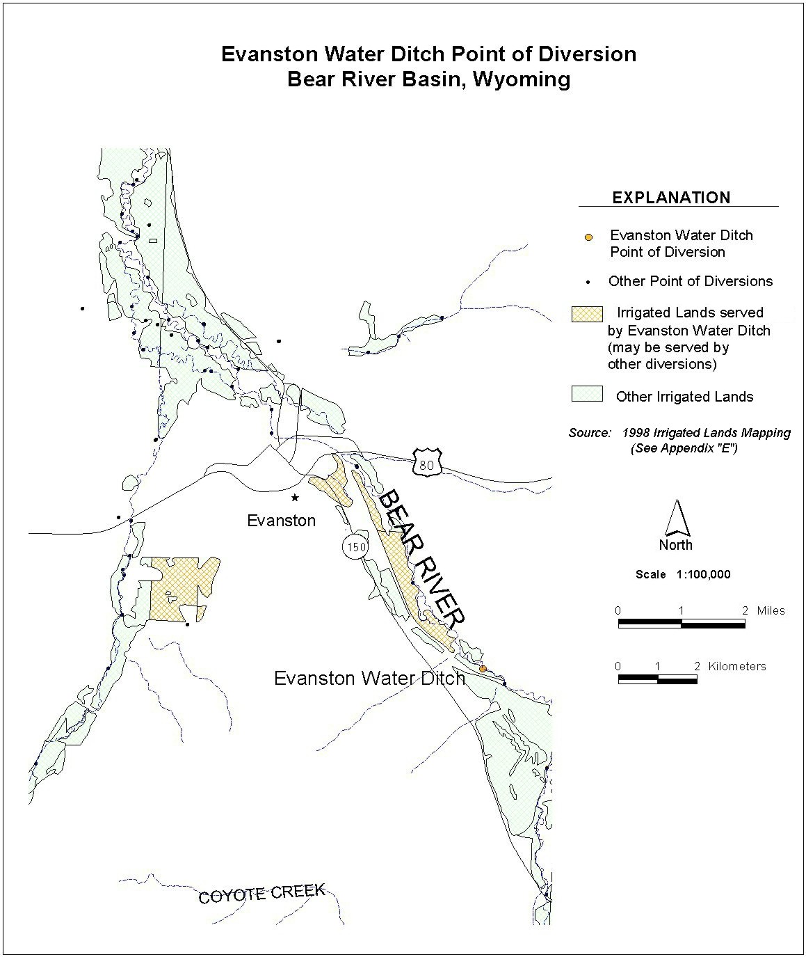
Appendix D Key Structures and Diversions EVANSTON WATER DITCH |
| PREPARED BY: | Bear River Basin Planning Team |
| DATE: | August 7, 2000 |
| Diversion Description: The headgate structure consists of a concrete headwall with a 48-inch wood slide gates. The south gate and outlet ditch has been abandoned. The north gate feeds into a 48-inch squash culvert through the dike. The river is diverted using wood planks supported on railroad ties driven vertically into the ground. | 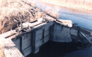 Evanston Ditch Headgate |
|
Conveyance Description: Open channel canal, approximately 47,520 feet in length.1
Direct Flow Water Rights:2
| Priority Date | Permit Number |
Permitted Use | Permitted Acres |
Flow (CFS) |
Cumulative (CFS) |
Comments |
|---|---|---|---|---|---|---|
| 03-28-1875 | Terr | Irrigation | 501.19 | 7.16 | 7.16 | |
| 03-28-1875 | Terr | Irrigation | 20 | 0.28 | 7.44 | |
| 03-28-1875 | Terr | Irrigation | 27.92 | 0.39 | 7.83 | |
| -1888 | Terr | Irrigation, Domestic, Storage | 110 | 1.57 | 9.40 | |
| 06-29-1906 | 1569E | Irrigation, Domestic, Storage | 40 | 0.57 | 9.97 | |
| 09-22-1915 | 3520E | Irrigation, Domestic, Storage | 308 | 4.41 | 14.38 | |
| 09-22-1915 | 3520E | Irrigation, Domestic, Storage | 20.79 | 0.30 | 14.68 | |
| 09-22-1915 | 3520E | Irrigation, Domestic, Storage | 115 | 1.64 | 16.32 | |
| 09-22-1915 | Supplemental Supply, Domestic, Storage | 33 | East (Sulphur Creek Canyon Springs) | |||
| 09-22-1915 | 3520E | Irrigation, Domestic, Storage | 242 | 2.46 | 19.77 | |
| 09-22-1915 | Supplemental Supply, Domestic, Storage | 232.00 | East (Sulphur Creek Canyon Springs) |
Associated Storage Rights:
| Reservoir | Shareholder | Volume (Acre-ft) |
Est. % of Shares Used this Diversion3 | Comments |
|---|---|---|---|---|
| Sulphur Creek | Duane Carpenter | 263 | 100% | |
| Sulphur Creek | Lowham Ranch LTD | 444 | 70% | |
| Sulphur Creek | Eldon Perkins | 11 | 100% | |
| Sulphur Creek | Ellsworth Pexton | 102 | 100% | |
| Sulphur Creek | Fred Stahley | 219 | 100% | |
| Sulphur Creek | Ralph Stahley | 16 | 100% | |
| Sulphur Creek | James Trout | 3 | 100% | |
| Sulphur Creek | Wyoming State Hosp. | 478 | 100% |
Irrigation Practices: Land is all flood irrigated.3
Estimated Diversion Efficiency:
Estimated Diversion Efficiency: Canal losses are relatively high due to porous nature of soils in the higher reaches of the Upper Bear.
Calculated Diversion Efficiency = Conveyance Efficiency X Application Efficiency:
Conveyance Efficiency: 65% Application Efficiency: 55% Overall Diversion Efficiency: 36% Conveyance efficiency is estimated by total length of main canal. Application efficiency for flood irrigation and sprinkler irrigation is estimated at 55% and 85% respectively.
Crop Types / Consumptive Use: Water is used primarily to irrigate mixed meadow grasses, primarily Meadow Foxtail, Redtop, etc. There is a some alfalfa in the Yellowcreek area. They rely on reservoir water for their second crop.
Return Flows: Return flow is primarily intercepted by the Rocky Mountain & Blythe Canal.
The following return flow pattern was adopted for modeling in this study are as follows:
		Month
      (after initial Diversion)	 Percent of Return
		0			70%
		1			20%
		2		        10%
                3                        0%
				       100%
References:
Monthly Diversion Records
Evanston Water Ditch
| YEAR | MAY | JUNE | JULY | AUGUST | SEPTEMBER | ||||||||||
|---|---|---|---|---|---|---|---|---|---|---|---|---|---|---|---|
| Total of Daily Ave for Month | Average CFS |
Monthly Total Ac-Ft |
Total of Daily Ave for Month | Average CFS |
Monthly Total Ac-Ft |
Total of Daily Ave for Month | Average CFS |
Monthly Total Ac-Ft |
Total of Daily Ave for Month | Average CFS |
Monthly Total Ac-Ft |
Total of Daily Ave for Month | Average CFS |
Monthly Total Ac-Ft | |
| *1970 | |||||||||||||||
| 1971 | 0 | 0.0 | 0.0 | 948 | 31.6 | 1880.3 | 813 | 26.2 | 1612.6 | 744 | 24.0 | 1475.7 | 228 | 7.6 | 452.2 |
| 1972 | 66 | 2.1 | 130.9 | 868 | 28.9 | 1721.7 | 581 | 18.7 | 1152.4 | 657 | 21.2 | 1303.1 | 0 | 0.0 | 0.0 |
| 1973 | 86 | 2.8 | 170.6 | 1041 | 34.7 | 2064.8 | 589 | 19.0 | 1168.3 | 589 | 19.0 | 1168.3 | 30 | 1.0 | 59.5 |
| 1974 | 55 | 1.8 | 109.1 | 1049 | 35.0 | 2080.7 | 566 | 18.3 | 1122.6 | 517 | 16.7 | 1025.5 | 97 | 3.2 | 192.4 |
| 1975 | 57 | 1.8 | 113.1 | 677 | 22.6 | 1342.8 | 725 | 23.4 | 1438.0 | 734 | 23.7 | 1455.9 | 174 | 5.8 | 345.1 |
| 1976 | 1 | 0.0 | 2.0 | 853 | 28.4 | 1691.9 | 772 | 24.9 | 1531.2 | 331 | 10.7 | 656.5 | 355 | 11.8 | 704.1 |
| 1977 | 235 | 7.6 | 466.1 | 619 | 20.6 | 1227.8 | 266 | 8.6 | 527.6 | 105 | 3.4 | 208.3 | 89 | 3.0 | 176.5 |
| 1978 | 134 | 4.3 | 265.8 | 691 | 23.0 | 1370.6 | 657 | 21.2 | 1303.1 | 296 | 9.5 | 587.1 | 214 | 7.1 | 424.5 |
| 1979 | 192 | 6.2 | 380.8 | 698 | 23.3 | 1384.5 | 531 | 17.1 | 1053.2 | 321 | 10.4 | 636.7 | 135 | 4.5 | 267.8 |
| 1980 | 0 | 0.0 | 0.0 | 349 | 11.6 | 692.2 | 572 | 18.5 | 1134.5 | 338 | 10.9 | 670.4 | 220 | 7.3 | 436.4 |
| 1981 | 3 | 0.1 | 6.0 | 411 | 13.7 | 815.2 | 433 | 14.0 | 858.8 | 393 | 12.7 | 779.5 | 197 | 6.6 | 390.7 |
| 1982 | 0 | 0.0 | 0.0 | 508 | 16.9 | 1007.6 | 480 | 15.5 | 952.1 | 404 | 13.0 | 801.3 | 218 | 7.3 | 432.4 |
| 1983 | 0 | 0.0 | 0.0 | 0 | 0.0 | 0.0 | 649 | 20.9 | 1287.3 | 171 | 5.5 | 339.2 | 5 | 0.2 | 9.9 |
| 1984 | 0 | 0.0 | 0.0 | 238 | 7.9 | 472.1 | 317 | 10.2 | 628.8 | 328 | 10.6 | 650.6 | 108 | 3.6 | 214.2 |
| 1985 | 135 | 4.4 | 267.8 | 419 | 14.0 | 831.1 | 445 | 14.4 | 882.6 | 332 | 10.7 | 658.5 | 199 | 6.6 | 394.7 |
| 1986 | 0 | 0.0 | 0.0 | 300 | 10.0 | 595.0 | 316 | 10.2 | 626.8 | 348 | 11.2 | 690.2 | 65 | 2.2 | 128.9 |
| 1987 | 350 | 11.3 | 694.2 | 356 | 11.9 | 706.1 | 443 | 14.3 | 878.7 | 197 | 6.4 | 390.7 | 32 | 1.1 | 63.5 |
| 1988 | 318 | 10.3 | 630.7 | 590 | 19.7 | 1170.2 | 530 | 17.1 | 1051.2 | 291 | 9.4 | 577.2 | 143 | 4.8 | 283.6 |
| 1989 | 534 | 17.2 | 1059.2 | 589 | 19.6 | 1168.3 | 553 | 17.8 | 1096.9 | 484 | 15.6 | 960.0 | 162 | 5.4 | 321.3 |
| 1990 | 311 | 10.0 | 616.9 | 609 | 20.3 | 1207.9 | 491 | 15.8 | 973.9 | 444 | 14.3 | 880.7 | 336 | 11.2 | 666.4 |
| 1991 | 193 | 6.2 | 382.8 | 592 | 19.7 | 1174.2 | 483 | 15.6 | 958.0 | 473 | 15.3 | 938.2 | 317 | 10.6 | 628.8 |
| 1992 | 488 | 15.7 | 967.9 | 609 | 20.3 | 1207.9 | 437 | 14.1 | 866.8 | 271 | 8.7 | 537.5 | 138 | 4.6 | 273.7 |
| 1993 | 55 | 1.8 | 109.1 | 442 | 14.7 | 876.7 | 483 | 15.6 | 958.0 | 375 | 12.1 | 743.8 | 178 | 5.9 | 353.1 |
| 1994 | 320 | 10.3 | 634.7 | 496 | 16.5 | 983.8 | 452 | 14.6 | 896.5 | 392 | 12.6 | 777.5 | 176 | 5.9 | 349.1 |
| 1995 | 0 | 0.0 | 0.0 | 278 | 9.3 | 551.4 | 347 | 11.2 | 688.3 | 387 | 12.5 | 767.6 | 185 | 6.2 | 366.9 |
| 1996 | 196 | 6.3 | 388.8 | 573 | 19.1 | 1136.5 | 479 | 15.5 | 950.1 | 419 | 13.5 | 831.1 | 241 | 8.0 | 478.0 |
| 1997 | 62.7 | 2.0 | 124.4 | 346.3 | 11.5 | 686.9 | 487 | 15.7 | 966.0 | 373 | 12.0 | 739.8 | 71.8 | 2.4 | 142.4 |
| 1998 | 108 | 3.5 | 214.2 | 167.7 | 5.6 | 332.6 | 412.6 | 13.3 | 818.4 | 426.5 | 13.8 | 846.0 | 241 | 8.0 | 478.0 |
| 1999 | 4 | 0.1 | 7.9 | 313 | 10.4 | 620.8 | 452 | 14.6 | 896.5 | 362 | 11.7 | 718.0 | 149 | 5.0 | 295.5 |
| AVERAGES | 4.3 | 267.0 | 18.0 | 1069.0 | 16.4 | 1009.6 | 12.8 | 786.7 | 5.4 | 321.7 | |||||