News and Information
 Newsletter Newsletter
Water Planning Process History
Historical Planning Documents
Wyoming Water Facts
River Basin Plans
Statewide Products
Bear River Basin
Green River Basin
NE River Basin
Platte River Basin
Powder/Tongue River Basin
Snake/Salt River Basin
Wind/Bighorn River Basin
Groundwater Reports
Basin Advisory Groups
Mission and Purpose
Calendar
Agendas
Meeting Records
Reference Material
Planning Products
GIS Web Mapping
Framework Water Plan
Platte Water Atlas
Water Search Engine
Send Us Your Comments
Partners
State Engineer's Office
Water Resources Data System
Contact Us
Water Plan Home Page
Water Development Office
|
2012 Snake/Salt River Basin Plan Update
Spreadsheet Model
Six spreadsheet workbooks and one master database were constructed for the 2012 Snake/Salt River Basin Plan to determine water availability based on dry, average and wet conditions within the basin.
For the 2012 Snake/Salt River Basin Plan Update the structure of the hydrologic spreadsheet models has not been altered from the previous plan. The only changes to the model were updates to the USGS gage and diversion data. The gage data were updated as described in the Surface Water Data Collection and Study Period Selection technical memorandum. The gage and diversion data were updated through 2010 and added to the model constituting a new study period of 1971 through 2010.
Please visit the related Technical Memordum page for instructions on using the model.
 Click Here To Download the 2010 Model Click Here To Download the 2010 Model
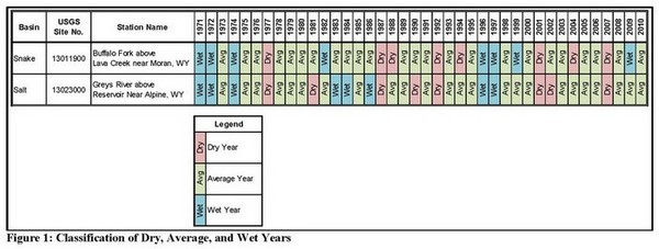 |
| Dry, Average, and Wet Years for USGS Indicator Gage Stations in Snake/Salt River Basin |
|

