Wyoming State Water Plan
Wyoming State Water Plan
Wyoming Water Development Office
6920 Yellowtail Rd
Cheyenne, WY 82002
Phone: 307-777-7626

Wyoming Water Development Office
6920 Yellowtail Rd
Cheyenne, WY 82002
Phone: 307-777-7626


TECHNICAL MEMORANDUM
Introduction:
Each basin in Wyoming has reservoirs that are used to store water for various purposes. These reservoirs range from small ponds for stock water to large reservoirs for hydroelectric power and irrigation. The major reservoirs in the Snake/Salt River basin are listed in this memorandum and its appendices along with associated data.
Facility Selection:
For consistency with the other Wyoming basin plans, data has been collected on all of the major reservoirs that are of particular significance to the basin. Facilities with capacities of 1000 acre-feet or larger define this criteria. In depth data regarding these reservoirs such as capacity tables and water rights have been compiled on each of these larger facilities.
In addition to the information on key storage facilities in the basin, an inventory of reservoirs was compiled. As with the other basin plans, facilities with a dam height of 20 feet or greater or with capacities of 50 acre-feet or greater were included in the inventory. These facilities are within the limits of the Safety of Dams Law coverage.
Methodology – Data Gathering:
Data on the various reservoirs included in this memorandum were collected from a variety of sources. The main source to determine what facilities would be included was a search of the Water Rights Database obtained from the State Engineer’s Office. Also used as a source of information was the Active Dams database, as some dams listed in the Water Rights Database are not currently in operation. The Tabulation of Surface Water Rights was used to determine the water source for some of the facilities. Information was also obtained from the U.S. Bureau of Reclamation on facilities under their management. It was found during the data collection that there are a number of larger dams that were permitted at one time yet were never built, or were built and have since been removed. Generally, these facilities were to be in the vicinity of Grand Teton National Park, and some were to enlarge existing lakes. Review of the Active Dams database as well as conversations with the National Park Service helped to determine if a particular dam was in place. Dams that either were not built or have been removed were not considered for this technical memorandum.
Compact & Court Decree Issues:
According to the technical memorandum prepared by Fassett Consulting entitled “Summary of Interstate Compacts and Court Decrees”, the Snake River Compact recognizes, without restriction, all existing water rights in Wyoming and Idaho established prior to July 1, 1949. It permits Wyoming unlimited use of water for domestic and stock watering purposes, providing stock water reservoirs shall not exceed 20 acre-feet in capacity. The compact allocates to Wyoming, for all future uses, the right to divert or store 4% of the Wyoming-Idaho state line flow of the Snake River. Idaho is entitled to the remaining 96% of the flow. The use of water is limited to diversions or storage within the Snake River drainage basin unless both states agree otherwise. The compact also provides preference for domestic, stock and irrigation use of the water over storage for the generation of power.
One unique aspect of the Snake River Compact, compared to other compacts to which Wyoming is a party, is a requirement that calls for Wyoming to provide Idaho replacement storage for one-third of any usage after the first 2% is put to beneficial use. Early estimates of these replacement storage quantities, based upon the average state line flow, are 33,000 acre-feet. A valuable technical result, provided in the technical memorandum prepared by Boyle Engineering entitled “Available Surface Water Determination”, is the update of Wyoming’s current use of water in the basin. This will provide the state and water users with an important component of information for future development and project planning.
In addition to the Snake River Compact, the Roxanna Decree is in effect on Teton Creek and South Leigh Creek which feed the Teton River. These streams are on the west side of the Teton Range and are not direct tributaries of the Snake River. According to the technical memorandum entitled “Summary of Interstate Compacts and Court Decrees”, the stipulation generally sets forth that Wyoming water users shall be unlimited in their diversions from Teton Creek and its tributaries until the measured flow of the creek diminishes to 170 cubic feet per second (cfs). After that, the Wyoming water users are limited to a diversion of 1 cfs for each 50 acres of irrigated land. When the flow further reduces to 90 cfs, the flow of Teton Creek and its tributaries is divided equally between the Wyoming and Idaho water users.
For South Leigh Creek, the stipulation generally provides the appropriators in Wyoming the unlimited diversion of water until the natural flow of the creek diminishes to a total of 16 cfs. At this time the Wyoming water users are then permitted to divert one-half of the streamflow and Idaho water users can divert the balance. In general, the Roxanna Decree does not affect any storage of water at this time.
Conclusion:
As stated in the Facility Selection section of this memo, in depth data on reservoirs with storage over 1,000 acre-feet has been collected, and is presented as Appendix A. A list of the facilities in Appendix A is shown in Table 1.
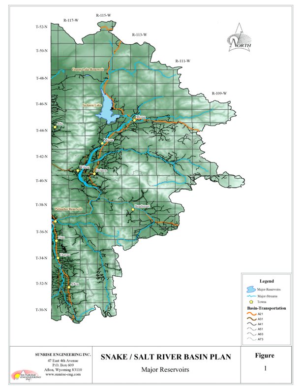
All of the major reservoir facilities in the Snake/Salt River basin are owned and managed by the U.S. Bureau of Reclamation for irrigation and hydropower production in Idaho. Jackson Lake Dam and Grassy Lake Dam are managed as part of the Minidoka Project, which provides irrigation water for over 1 million acres of farmland in Idaho. Palisades Dam, part of the Palisades Project, is also managed in conjunction with the Minidoka Project. The locations of these major reservoirs are shown in Figure 1. Also, an inventory of facilities with capacity at 50 acre-feet or larger is compiled in Appendix B
Table 1. Major Reservoirs in the Snake/Salt River Basin
| Reservoir | Permit No. |
Year Complete |
Normal
Capacity (acre-feet) |
Dam Height (feet) |
Surface Area (acres) |
| Grassy Lake | 4631R | 1939 | 15,182 | 70 | 310 |
| Jackson Lake | Various | 1911 | 847,000 | 65 | 25,530 |
| Palisades | Idaho | 1957 | 1,200,000 | 270 | 16,150 |
Lake evaporation data included in the inventory was obtained from the Annual Lake Evaporation presented in Development of an Evaporation Map for the State of Wyoming for Purposes of Estimating Evaporation and Evapotranspiration by Larry E. Lewis. The annual lake evaporation estimates were distributed among the months of the growing season using Table IX as instructed on page 58 of the Lewis report. This method of assigning evaporation to the various reservoirs is similar to that used in other recent Wyoming basin studies.
Resources:
Fassett Consulting, Summary of Interstate Compacts and Court Decrees, Technical Memorandum, Snake/Salt River Basin Plan, 2002.
Lewis, Larry Eugene, University of Wyoming, Development of an Evaporation Map for the State of Wyoming for Purposes of Estimating Evaporation and Evapotranspiration, May, 1978.
Wyoming State Engineer’s Office, “Search Results from Active Dams Database”, transmitted by Larry Stockdale, March 26, 2002.
Wyoming State Engineer’s Office, “Search Results from Water Rights Database,” transmitted by Jeff Davis, October 19, 2001.
Wyoming State Engineer’s Office, Tabulation of Adjudicated Surface Water Rights of the State of Wyoming, Water Division Number Four, October 1999.
U.S. Bureau of Reclamation, Dataweb (http://www.usbr.gov/dataweb/) [new link 10/2009 HERE] , information on various dams, 2001-2002.
Key Storage Facilities
Facility: Grassy Lake Reservoir
Location: 25 miles northwest of Moran, 35 miles east of Ashton, ID. T48N, R116W.
Owner: U.S. Bureau of Reclamation
Year of Construction: 1937-9
Enlargement History: None
Total Storage: 16,200 acre-feet
Active Storage: 15,182 acre-feet
Dead Storage: Unknown due to natural portion of Grassy Lake
Area/Capacity Data: Maximum Surface Area = 310 acres
| Elevation (feet) | Capacity (acre-feet) | Area (acres) |
| 7135 | 0 | 65 |
| 7136 | 68 | 70 |
| 7137 | 138 | 75.0 |
| 7138 | 217 | 79 |
| 7139 | 297 | 84 |
| 7140 | 384 | 88 |
| 7141 | 474 | 91 |
| 7142 | 565 | 95 |
| 7143 | 665 | 99.0 |
| 7144 | 765 | 103 |
| 7145 | 869 | 107 |
| 7146 | 979 | 111 |
| 7147 | 1,090 | 116 |
| 7148 | 1,210 | 120.0 |
| 7149 | 1,330 | 124 |
| 7150 | 1,458 | 129 |
| 7151 | 1,588 | 133 |
| 7152 | 1,722 | 137 |
| 7153 | 1,862 | 141 |
| 7154 | 2,002 | 145 |
| 7155 | 2,151 | 148 |
| 7156 | 2,301 | 152 |
| 7157 | 2,455 | 157 |
| 7158 | 2,615 | 161 |
| 7159 | 2,775 | 165 |
| 7160 | 2,944 | 169 |
| 7161 | 3,114 | 173 |
| 7162 | 3,289 | 177 |
| 7163 | 3,469 | 180 |
| 7164 | 3,649 | 184 |
| 7165 | 3,837 | 188 |
| 7166 | 4,027 | 192 |
| 7167 | 4,220 | 196 |
| 7168 | 442 | 199 |
| 7169 | 4,620 | 203 |
| 7170 | 4,821 | 206 |
| 7171 | 5,031 | 209 |
| 7172 | 5,241 | 211 |
| 7173 | 5,451 | 214 |
| 7174 | 5,668 | 217 |
| 7175 | 588 | 219.0 |
| 7176 | 6,108 | 222 |
| 7177 | 6,328 | 224.0 |
| 7178 | 6,555 | 227 |
| 7179 | 6,785 | 229 |
| 7180 | 7,015 | 232 |
| 7181 | 7,245 | 235 |
| 7182 | 7,483 | 237 |
| 7183 | 7,723 | 240 |
| 7184 | 7,963 | 243 |
| 7185 | 8,204 | 245 |
| 7186 | 8,454 | 248 |
| 7187 | 8,704 | 250 |
| 7188 | 8,954 | 253 |
| 7189 | 9,205 | 256 |
| 7190 | 9,465 | 258.0 |
| 7191 | 9,725 | 261 |
| 7192 | 9,985 | 264 |
| 7193 | 10,251 | 267 |
| 7194 | 10,521 | 270 |
| 7195 | 10,791 | 273 |
| 7196 | 11,062 | 276 |
| 7197 | 11,342 | 278 |
| 7198 | 11,622 | 281.0 |
| 7199 | 11,902 | 284 |
| 7200 | 12,187 | 287 |
| 7201 | 12,477 | 289.2 |
| 7202 | 12,767 | 292 |
| 7203 | 13,057 | 294 |
| 7204 | 13,355 | 297 |
| 7205 | 13,655 | 299 |
| 7206 | 13,955 | 302 |
| 7207 | 14,255 | 304 |
| 7208 | 14,562 | 306.8 |
| 7209 | 14,872 | 309.2 |
| 7210 | 15,182 | 311.5 |
| 7211 | 15,492 | 313.9 |
| 7212 | 15,808 | 316.4 |
| 7213 | 16,128 | 319.0 |
| 7214 | 16,448 | 321.7 |
| 7215 | 16,768 | 324.3 |
Dam Construction Type: Zoned Earthfill/Rockfill. Dam Height = 118 feet.
End-of-Month Storage Records:
Water Rights:
| Permit Number | Permitted Use | Priority Date | Volume(af) |
| 4631R | POW, IRR, DOM | 2/13/1936 | 15,204 |
Designated Use: Power Generation, Irrigation Storage, Domestic Use
Recreational Use:
Associated Irrigation Diversions: Fremont-Madison Irrigation District
Operational Discussion: Grassy Lake is managed by the U.S. Bureau of Reclamation as part of the Minidoka Project. As part of this project, the dam provides supplemental irrigation to the Fremont-Madison Irrigation District in Idaho.
Resources: Active Dams, State Engineer’s Office, transmitted by Larry Stockdale, March 26, 2002.
Search Results from Water Rights Database, State Engineer’s Office, transmitted by Jeff Davis on October 19, 2001.
DataWeb, U.S. Bureau of Reclamation
Facility: Jackson Lake
Location: Thirty miles north of Jackson on the South Fork of the Snake River. T44-48N, R114-116W.
Owner: U.S. Bureau of Reclamation
Year of Construction: 1910-1911
Enlargement History: 1916
Total Storage:
Active Storage: 847,000 acre-feet
Dead Storage: Unknown due to natural portion of Jackson Lake
Area/Capacity Data: Maximum Surface Area = 25,530 acres
| Elevation (feet) | Capacity (acre-feet) | Area (acres) |
| 6730 | 0 | 17,100 |
| 6731 | 17,190 | 17,290 |
| 6732 | 34,580 | 17,490 |
| 6733 | 52,180 | 17,710 |
| 6734 | 70,010 | 17,940 |
| 6735 | 88,070 | 18,190 |
| 6736 | 106,390 | 18,450 |
| 6737 | 124,980 | 18,730 |
| 6738 | 143,860 | 19,020 |
| 6739 | 163,030 | 19,330 |
| 6740 | 182,520 | 19,650 |
| 6741 | 202,330 | 19,960 |
| 6742 | 222,430 | 20,050 |
| 6743 | 242,830 | 20,540 |
| 6744 | 263,500 | 20,810 |
| 6745 | 284,450 | 21,080 |
| 6746 | 305,660 | 21,340 |
| 6747 | 327,120 | 21,580 |
| 6748 | 348,820 | 21,820 |
| 6749 | 370,750 | 22,040 |
| 6750 | 392,910 | 22,250 |
| 6751 | 415,260 | 22,460 |
| 6752 | 437,810 | 22,650 |
| 6753 | 460,550 | 22,830 |
| 6754 | 483,470 | 23,000 |
| 6755 | 506,550 | 23,160 |
| 6756 | 529,790 | 23,320 |
| 6757 | 553,190 | 23,480 |
| 6758 | 576,750 | 23,640 |
| 6759 | 600,470 | 23,800 |
| 6760 | 624,360 | 23,970 |
| 6761 | 648,400 | 24,130 |
| 6762 | 672,620 | 24,300 |
| 6763 | 697,000 | 24,470 |
| 6764 | 721,560 | 24,640 |
| 6765 | 746,280 | 24,810 |
| 6766 | 771,180 | 24,990 |
| 6767 | 796,260 | 25,170 |
| 6768 | 821,520 | 25,350 |
| 6769 | 847,000 | 25,540 |
| 6770 | 872,600 | 25,730 |
Dam Construction Type: Combined concrete gravity and zoned earthfill. Dam Height = 65 feet.
End-of-Month Storage Records:
Average End of Month Contents, 1971-2001 (based on preliminary data)
| Month | Contents (acre-feet) |
| October | 472,980 |
| November | 478,820 |
| December | 486,680 |
| January | 494,830 |
| February | 498,650 |
| March | 491,640 |
| April | 477,330 |
| May | 578,780 |
| June | 692,740 |
| July | 656,330 |
| August | 549,200 |
| September | 461,050 |
| Permit Number | Permitted Use | Priority Date | Volume(af) |
| 894R | IRR | 8/23/1906 | 299,000 |
| 1903R | IRR | 8/18/1910 | 392,990 |
| 2185R | IRR | 7/24/1911 | 438,000 |
| 2894R | IRR | 5/20/1912 | 738,000 |
| 2895R | IRR, DOM | 5/24/1913 | 838,000 |
Designated Use: Irrigation Storage, Domestic Use
Recreational Use: Boating, Fishing, Camping, Wildlife
Associated Irrigation Diversions: None
Operational Discussion: Jackson Lake Dam is managed by the U.S. Bureau of Reclamation as part of the Minidoka Project. As part of this project, the dam provides irrigation supply to the irrigation districts in Idaho. Seasonal flows from the dam are also coordinated with the Wyoming Game and Fish Department in order to provide adequate flows for fish in the Snake River.
Resources: DataWeb, U.S. Bureau of Reclamation
Search Results from Water Rights Database, State Engineer’s Office, transmitted by Jeff Davis on October 19, 2001.
Mike Beus, U.S. Bureau of Reclamation, Telephone Interview, May 29, 2002.
Area and Capacity for Jackson Lake Reservoir, U.S. Bureau of Reclamation, received from Mike Beus, July 15, 2002.
Facility: Palisades Reservoir
Location: Eighteen miles northwest of Alpine on the South Fork of the Snake River in Bonneville County, Idaho.
Owner: U.S. Bureau of Reclamation
Year of Construction: 1951-1957
Enlargement History: None
Total Storage: 1,401,000 acre-feet
Active Storage: 1,200,000 acre-feet
Dead Storage: 44,100 acre-feet
Area/Capacity Data:
| Elevation (feet) | Capacity (acre-feet) | Area (acres) |
| 5498 | 499 | 4,972 |
| 5499 | 5,509 | 5,046 |
| 5500 | 10,592 | 5,121 |
| 5501 | 15,751 | 5,197 |
| 5502 | 20,987 | 5,275 |
| 5503 | 26,302 | 5,354 |
| 5504 | 31,696 | 5,434 |
| 5505 | 37,170 | 5,514 |
| 5506 | 42,723 | 5,592 |
| 5507 | 48,354 | 5,670 |
| 5508 | 54,061 | 5,745 |
| 5509 | 59,842 | 5,818 |
| 5510 | 65,695 | 5,887 |
| 5511 | 71,614 | 5,952 |
| 5512 | 77,596 | 6,012 |
| 5513 | 83,636 | 6,068 |
| 5514 | 89,732 | 6,123 |
| 5515 | 95,881 | 6,176 |
| 5516 | 102,084 | 6,230 |
| 5517 | 108,341 | 6,284 |
| 5518 | 114,654 | 6,342 |
| 5519 | 121,026 | 6,403 |
| 5520 | 127,462 | 6,469 |
| 5521 | 133,967 | 6,540 |
| 5522 | 140,545 | 6,615 |
| 5523 | 147,199 | 6,694 |
| 5524 | 153,933 | 6,774 |
| 5525 | 160,749 | 6,857 |
| 5526 | 167,647 | 6,940 |
| 5527 | 174,629 | 7,023 |
| 5528 | 181,693 | 7,106 |
| 5529 | 188,839 | 7,187 |
| 5530 | 196,065 | 7,265 |
| 5531 | 203,368 | 7,342 |
| 5532 | 210,748 | 7,418 |
| 5533 | 218,203 | 7,493 |
| 5534 | 225,733 | 7,568 |
| 5535 | 233,338 | 7,642 |
| 5536 | 241,017 | 7,716 |
| 5537 | 248,769 | 7,790 |
| 5538 | 256,596 | 7,862 |
| 5539 | 264,496 | 7,936 |
| 5540 | 272,469 | 8,010 |
| 5541 | 280,515 | 8,083 |
| 5542 | 288,634 | 8,155 |
| 5543 | 296,826 | 8,227 |
| 5544 | 305,089 | 8,299 |
| 5545 | 313,423 | 8,370 |
| 5546 | 321,829 | 8,442 |
| 5547 | 330,307 | 8,514 |
| 5548 | 338,857 | 8,587 |
| 5549 | 347,481 | 8,661 |
| 5550 | 356,179 | 8,736 |
| 5551 | 364,954 | 8,813 |
| 5552 | 373,805 | 8,891 |
| 5553 | 382,735 | 8,969 |
| 5554 | 391,744 | 9,049 |
| 5555 | 400,833 | 9,129 |
| 5556 | 410,003 | 8,210 |
| 5557 | 419,252 | 9,290 |
| 5558 | 428,582 | 9,370 |
| 5559 | 437,991 | 9,449 |
| 5560 | 447,479 | 9,527 |
| 5561 | 457,045 | 9,604 |
| 5562 | 466,687 | 9,681 |
| 5563 | 476,406 | 9,757 |
| 5564 | 486,200 | 9,832 |
| 5565 | 496,070 | 9,908 |
| 5566 | 506,015 | 9,983 |
| 5567 | 516,036 | 10,059 |
| 5568 | 526,133 | 10,135 |
| 5569 | 536,306 | 10,211 |
| 5570 | 546,556 | 10,289 |
| 5571 | 556,883 | 10,366 |
| 5572 | 567,287 | 10,441 |
| 5573 | 577,765 | 10,515 |
| 5574 | 588,317 | 10,589 |
| 5575 | 598,944 | 10,665 |
| 5576 | 609,647 | 10,742 |
| 5577 | 620,429 | 10,822 |
| 5578 | 631,292 | 10,905 |
| 5579 | 642,241 | 10,993 |
| 5580 | 653,281 | 11,087 |
| 5581 | 664,417 | 11,185 |
| 5582 | 675,653 | 11,286 |
| 5583 | 686,911 | 11,391 |
| 5584 | 698,436 | 11,498 |
| 5585 | 709,990 | 11,609 |
| 5586 | 721,656 | 11,724 |
| 5587 | 733,439 | 11,843 |
| 5588 | 745,343 | 11,965 |
| 5589 | 757,371 | 12,091 |
| 5590 | 769,528 | 12,222 |
| 5591 | 781,819 | 12,359 |
| 5592 | 794,250 | 12,504 |
| 5593 | 806,830 | 12,656 |
| 5594 | 819,564 | 12,811 |
| 5595 | 832,454 | 12,970 |
| 5596 | 845,504 | 13,129 |
| 5597 | 858,712 | 13,288 |
| 5598 | 872,078 | 13,444 |
| 5599 | 885,598 | 13,596 |
| 5600 | 899,267 | 13,742 |
| 5601 | 913,079 | 13,884 |
| 5602 | 927,034 | 14,024 |
| 5603 | 941,127 | 14,163 |
| 5604 | 955,359 | 14,300 |
| 5605 | 969,727 | 14,435 |
| 5606 | 984,288 | 14,568 |
| 5607 | 998,861 | 14,698 |
| 5608 | 1,013,623 | 14,826 |
| 5609 | 1,028,512 | 14,951 |
| 5610 | 1,043,524 | 15,073 |
| 5611 | 1,058,657 | 15,194 |
| 5612 | 1,073,912 | 15,315 |
| 5613 | 1,089,286 | 15,435 |
| 5614 | 1,104,780 | 15,553 |
| 5615 | 1,120,390 | 15,667 |
| 5616 | 1,136,112 | 15,777 |
| 5617 | 1,151,941 | 15,882 |
| 5618 | 1,167,871 | 15,979 |
| 5619 | 1,183,896 | 16,069 |
| 5620 | 1,200,000 | 16,150 |
| 5621 | 1,216,219 | 16,266 |
Dam Construction Type: Zoned earthfill. Dam Height = 270 feet
End-of-Month Storage Records:
Average End of Month Contents, 1971-2001 (based on preliminary data)
| Month | Contents (acre-feet) |
| October | 745,910 |
| November | 797,340 |
| December | 821,430 |
| January | 827,240 |
| February | 821,890 |
| March | 735,840 |
| April | 661,780 |
| May | 826,600 |
| June | 1,060,580 |
| July | 926,680 |
| August | 801,090 |
| September | 716,400 |
Water Rights: Water rights for Palisades Reservoir are administered by the State of Idaho.
Designated Use: Irrigation Storage, Power Generation, Flood Control, Fish and Wildlife
Recreational Use: Boating, Fishing, Camping, Wildlife
Associated Irrigation Diversions: Downstream diversions are located in Idaho
Operational Discussion: Palisades Dam is part of the Palisades Project, which serves purposes such as irrigation, power generation, flood control, recreation, and fish and wildlife conservation. The dam is also operated in conjunction with the Minidoka Project to provide holdover storage for irrigation and power generation
In 1991, the U.S. Bureau of Reclamation entered into a contract with the State of Wyoming for the purchase of 33,000 acre-feet of joint use space in the reservoir. All Palisades Reservoir spaceholder contracts provide for use of a proportionate share of the water accruing to the reservoir water rights, the ability to keep unused stored water for use in subsequent years, and the option of participating in the Water District 1 Rental Pool. Additionally, Wyoming has the option of making exchanges to allow the use of their Palisades Reservoir space to retain water in Jackson Lake or to increase winter flows in the Snake River for cutthroat trout. The space also insures Wyoming’s ability to fulfill Snake River Compact obligations.
Resources: DataWeb, U.S. Bureau of Reclamation
Storage Facility Inventory
| Afton Electric Reservoir | ||||||
| Tributary: | Swift Creek, Tributary Salt River | |||||
| Permit No. |
Owner/Operator | Year Completed |
Location | |||
| S-T-R | Latitude | Longitude | ||||
| 4091R | Town of Afton | 1938 | 29, T32N, R118W |
42º43’32” | 110º54’32” | |
| Dam Height (ft) | Max. Capacity (af) |
Normal Capacity (af) |
Max. Surface Area (acres) |
Purposes | ||
| 30 | 69 | 48 | 5 | P | ||
| Lewis Evaporation Estimates (inches/acre) | ||||||
| Annual | May-Sept. | May | June | July | August | September |
| 40 | 27.52 | 4.82 | 5.59 | 6.71 | 6.16 | 4.24 |
| Baldwin Reservoir | ||||||
| Tributary: | Teton Creek | |||||
| Permit No. |
Owner/Operator | Year Completed |
Location | |||
| S-T-R | Latitude | Longitude | ||||
| 10498R | Alfred E. Baldwin | 1995 | 21, T44N, R118W |
|||
| Dam Height (ft) | Max. Capacity (af) |
Normal Capacity (af) |
Max. Surface Area (acres) |
Purposes | ||
| 20 | 30 | 3 | S,F | |||
| Lewis Evaporation Estimates (inches/acre) | ||||||
| Annual | May-Sept. | May | June | July | August | September |
| 34 | 23.39 | 4.09 | 4.75 | 5.71 | 5.24 | 3.60 |
| Beaver Pond Reservoir | ||||||
| Tributary: | Dry Gulch | |||||
| Permit No. |
Owner/Operator | Year Completed |
Location | |||
| S-T-R | Latitude | Longitude | ||||
| 1424R | Royer & Shinkle | 1908 | 18, T43N, R114W |
|||
| Dam Height (ft) | Max. Capacity (af) |
Normal Capacity (af) |
Max. Surface Area (acres) |
Purposes | ||
| 10 | 79 | 11 | I | |||
| Lewis Evaporation Estimates (inches/acre) | ||||||
| Annual | May-Sept. | May | June | July | August | September |
| 34 | 23.39 | 4.09 | 4.75 | 5.71 | 5.24 | 3.6 |
| Bergman Lake Reservoir | ||||||
| Tributary: | Indian Creek, Trib. Squirrel Cr., Trib falls R., Trib. Henrys Fk. R. | |||||
| Permit No. |
Owner/Operator | Year Completed |
Location | |||
| S-T-R | Latitude | Longitude | ||||
| 6001R | Squirrel Creek Irrigation Company |
1953 | 5, T47N, R118W |
44º03’34” | 111º02’20” | |
| Dam Height (ft) | Max. Capacity (af) |
Normal Capacity (af) |
Max. Surface Area (acres) |
Purposes | ||
| 12 | 373 | 201 | 37 | I | ||
| Lewis Evaporation Estimates (inches/acre) | ||||||
| Annual | May-Sept. | May | June | July | August | September |
| 33 | 22.70 | 3.97 | 4.61 | 5.54 | 5.09 | 3.50 |
| Cottonwood Lake | ||||||
| Tributary: | Cottonwood Creek, Tributary Salt River | |||||
| Permit No. |
Owner/Operator | Year Completed |
Location | |||
| S-T-R | Latitude | Longitude | ||||
| 0253R | U.S. Forest Service | 1918 | 30, T31N, R117W |
42º38’09” | 110º49’02” | |
| Dam Height (ft) | Max. Capacity (af) |
Normal Capacity (af) |
Max. Surface Area (acres) |
Purposes | ||
| 11 | 240 | 70 | 32 | I | ||
| Lewis Evaporation Estimates (inches/acre) | ||||||
| Annual | May-Sept. | May | June | July | August | September |
| 41 | 28.21 | 4.94 | 5.73 | 6.88 | 6.32 | 4.34 |
| Flat Creek Ranch Reservoir | ||||||
| Tributary: | Flat Creek, Tributary Little Gros Ventre River | |||||
| Permit No. |
Owner/Operator | Year Completed |
Location | |||
| S-T-R | Latitude | Longitude | ||||
| 9068R | Flat Creek Ranch | 1967 | 8, T41N, R114W |
43º31’29” | 110º32’27” | |
| Dam Height (ft) | Max. Capacity (af) |
Normal Capacity (af) |
Max. Surface Area (acres) |
Purposes | ||
| 11 | 151 | 46 | R,F | |||
| Lewis Evaporation Estimates (inches/acre) | ||||||
| Annual | May-Sept. | May | June | July | August | September |
| 34 | 23.39 | 4.09 | 4.75 | 5.71 | 5.24 | 3.60 |
| Grassy Lake | ||||||
| Tributary: | Grassy Creek, Tributary Snake River | |||||
| Permit No. |
Owner/Operator | Year Completed |
Location | |||
| S-T-R | Latitude | Longitude | ||||
| 4631R | U.S. Bureau of Reclamation |
1939 | T48N, R116W |
44º07’48” | 110º49’06” | |
| Dam Height (ft) | Max. Capacity (af) |
Normal Capacity (af) |
Max. Surface Area (acres) |
Purposes | ||
| 118 | 16,200 | 15,182 | 310 | P,I,D | ||
| Lewis Evaporation Estimates (inches/acre) | ||||||
| Annual | May-Sept. | May | June | July | August | September |
| 32 | 22.02 | 3.85 | 4.47 | 5.37 | 4.93 | 3.39 |
| Hardeman Reservoir | ||||||
| Tributary: | Springs, Beaver Lake, Tributary Snake River | |||||
| Permit No. |
Owner/Operator | Year Completed |
Location | |||
| S-T-R | Latitude | Longitude | ||||
| 5603R | Gerrit Hardeman | 1947 | 18, T43N, R114W |
|||
| Dam Height (ft) | Max. Capacity (af) |
Normal Capacity (af) |
Max. Surface Area (acres) |
Purposes | ||
| 15 | 93 | 13 | S,I | |||
| Lewis Evaporation Estimates (inches/acre) | ||||||
| Annual | May-Sept. | May | June | July | August | September |
| 34 | 23.39 | 4.09 | 4.75 | 5.71 | 5.24 | 3.60 |
| Hardeman #2 Reservoir | ||||||
| Tributary: | Hardeman Creek, Tributary Snake River | |||||
| Permit No. |
Owner/Operator | Year Completed |
Location | |||
| S-T-R | Latitude | Longitude | ||||
| 5737R | Gerrit Hardeman | 1950 | 21, T43N, R114W |
|||
| Dam Height (ft) | Max. Capacity (af) |
Normal Capacity (af) |
Max. Surface Area (acres) |
Purposes | ||
| 15 | 133 | 19 | I,D | |||
| Lewis Evaporation Estimates (inches/acre) | ||||||
| Annual | May-Sept. | May | June | July | August | September |
| 34 | 23.39 | 4.09 | 4.75 | 5.71 | 5.24 | 3.60 |
| Indian Lake Reservoir | ||||||
| Tributary: | Indian Lake Basin, Tributary Snake River | |||||
| Permit No. |
Owner/Operator | Year Completed |
Location | |||
| S-T-R | Latitude | Longitude | ||||
| 6000R | Squirrel Creek Irrigation Company |
1954 | 4, T47N, R118W |
44º04'01" | 111º02'07" | |
| Dam Height (ft) | Max. Capacity (af) |
Normal Capacity (af) |
Max. Surface Area (acres) |
Purposes | ||
| 10 | 2034 | 904 | 252 | I | ||
| Lewis Evaporation Estimates (inches/acre) | ||||||
| Annual | May-Sept. | May | June | July | August | September |
| 31 | 21.33 | 3.73 | 4.33 | 5.20 | 4.78 | 3.28 |
| Jackson Lake | ||||||
| Tributary: | Snake River | |||||
| Permit No. |
Owner/Operator | Year Completed |
Location | |||
| S-T-R | Latitude | Longitude | ||||
| 2895R | U.S.Bureau of Reclamation |
1911 | T44-48N, R114-6W |
43º51'36" | 110º35'24" | |
| Dam Height (ft) | Max. Capacity (af) |
Normal Capacity (af) |
Max. Surface Area (acres) |
Purposes | ||
| 65 | 873,000 | 847,000 | 25,530 | I,D | ||
| Lewis Evaporation Estimates (inches/acre) | ||||||
| Annual | May-Sept. | May | June | July | August | September |
| 32 | 22.02 | 3.85 | 4.47 | 5.37 | 4.93 | 3.39 |
| Jackson Wastewater Treatment Plant | ||||||
| Tributary: | Snake River | |||||
| Permit No. |
Owner/Operator | Year Completed |
Location | |||
| S-T-R | Latitude | Longitude | ||||
| 8114R | Town of Jackson | 1980 | 43º24'05" | 110º46'53" | ||
| Dam Height (ft) | Max. Capacity (af) |
Normal Capacity (af) |
Max. Surface Area (acres) |
Purposes | ||
| 23 | 260 | 20 | D | |||
| Lewis Evaporation Estimates (inches/acre) | ||||||
| Annual | May-Sept. | May | June | July | August | September |
| 36 | 24.77 | 4.33 | 5.03 | 6.04 | 5.55 | 3.81 |
| Leidy Lake | ||||||
| Tributary: | Leidy Creek, Tributary South Fork Spread Creek | |||||
| Permit No. |
Owner/Operator | Year Completed |
Location | |||
| S-T-R | Latitude | Longitude | ||||
| 8632R | Wyoming Game & Fish Department |
1983 | 2,T43N, R113W |
43º43'13" | 110º22'21" | |
| Dam Height (ft) | Max. Capacity (af) |
Normal Capacity (af) |
Max. Surface Area (acres) |
Purposes | ||
| 8 | 65 | 14 | F | |||
| Lewis Evaporation Estimates (inches/acre) | ||||||
| Annual | May-Sept. | May | June | July | August | September |
| 33 | 22.70 | 3.97 | 4.61 | 5.54 | 5.09 | 3.50 |
| McLean Reservoir | ||||||
| Tributary: | McLean Creek, Tributary Muddy Creek, Tributary Hoback River | |||||
| Permit No. |
Owner/Operator | Year Completed |
Location | |||
| S-T-R | Latitude | Longitude | ||||
| 5484R | Miller Land & Livestock Company |
1965 | 23,T36N, R113W |
|||
| Dam Height (ft) | Max. Capacity (af) |
Normal Capacity (af) |
Max. Surface Area (acres) |
Purposes | ||
| 20 | 16 | 3 | S | |||
| Lewis Evaporation Estimates (inches/acre) | ||||||
| Annual | May-Sept. | May | June | July | August | September |
| 37 | 25.46 | 4.45 | 5.17 | 6.21 | 5.70 | 3.92 |
| Melody Ranch Pond | ||||||
| Tributary: | Flat Creek, Little Gros Ventre | |||||
| Permit No. |
Owner/Operator | Year Completed |
Location | |||
| S-T-R | Latitude | Longitude | ||||
| 9884R | Melody Ranch | 1993 | 28, T40N, R116W |
|||
| Dam Height (ft) | Max. Capacity (af) |
Normal Capacity (af) |
Max. Surface Area (acres) |
Purposes | ||
| 70 | 6 | F | ||||
| Lewis Evaporation Estimates (inches/acre) | ||||||
| Annual | May-Sept. | May | June | July | August | September |
| 37 | 25.46 | 4.45 | 5.17 | 6.21 | 5.70 | 3.92 |
| Porter Reservoir | ||||||
| Tributary: | Wallace Creek, Tributary Shive Spring Branch, Trib. Buffalo Fork | |||||
| Permit No. |
Owner/Operator | Year Completed |
Location | |||
| S-T-R | Latitude | Longitude | ||||
| 5735R | Bruce Porter Estate | 1951 | 2,T44N, R113W |
43º48'01" | 110º23'15" | |
| Dam Height (ft) | Max. Capacity (af) |
Normal Capacity (af) |
Max. Surface Area (acres) |
Purposes | ||
| 17 | 52 | 52 | 7 | S,I,D | ||
| Lewis Evaporation Estimates (inches/acre) | ||||||
| Annual | May-Sept. | May | June | July | August | September |
| 32 | 22.02 | 3.85 | 4.47 | 5.37 | 4.93 | 3.39 |
| Strawberry Creek Reservoir | ||||||
| Tributary: | Strawberry Creek, Tributary Salt River | |||||
| Permit No. |
Owner/Operator | Year Completed |
Location | |||
| S-T-R | Latitude | Longitude | ||||
| 5684R | Lower Valley Energy | 1949 | 30, T34N, R117W |
|||
| Dam Height (ft) | Max. Capacity (af) |
Normal Capacity (af) |
Max. Surface Area (acres) |
Purposes | ||
| 22 | 10 | 3 | P | |||
| Lewis Evaporation Estimates (inches/acre) | ||||||
| Annual | May-Sept. | May | June | July | August | September |
| 39 | 26.83 | 4.70 | 5.45 | 6.55 | 6.01 | 4.13 |
| Teal Reservoir | ||||||
| Tributary: | Salt River | |||||
| Permit No. |
Owner/Operator | Year Completed |
Location | |||
| S-T-R | Latitude | Longitude | ||||
| 9837R | Wyoming Game & Fish Department |
1992 | 3, T44N, R119W |
|||
| Dam Height (ft) | Max. Capacity (af) |
Normal Capacity (af) |
Max. Surface Area (acres) |
Purposes | ||
| 10 | 79 | 32 | WL,WT | |||
| Lewis Evaporation Estimates (inches/acre) | ||||||
| Annual | May-Sept. | May | June | July | August | September |
| 40 | 27.52 | 4.82 | 5.59 | 6.71 | 6.16 | 4.24 |
| Timber Creek Reservoir | ||||||
| Tributary: | Timber Creek, Tributary Snake River | |||||
| Permit No. |
Owner/Operator | Year Completed |
Location | |||
| S-T-R | Latitude | Longitude | ||||
| 2108R | Mary A. Cheney | 1911 | 15, T44N, R116W |
|||
| Dam Height (ft) | Max. Capacity (af) |
Normal Capacity (af) |
Max. Surface Area (acres) |
Purposes | ||
| 30 | 13 | 1 | I,D | |||
| Lewis Evaporation Estimates (inches/acre) | ||||||
| Annual | May-Sept. | May | June | July | August | September |
| 37 | 25.46 | 4.45 | 5.17 | 6.21 | 5.70 | 3.92 |
| Tracy Lake | ||||||
| Tributary: | Randolph Creek, Brush Creek, and Buffalo Fork River | |||||
| Permit No. |
Owner/Operator | Year Completed |
Location | |||
| S-T-R | Latitude | Longitude | ||||
| 9447R | ANK Corporation | 1928 | 19, T44N, R112W |
43º50'54" | 110º22'00" | |
| Dam Height (ft) | Max. Capacity (af) |
Normal Capacity (af) |
Max. Surface Area (acres) |
Purposes | ||
| 20 | 646 | 380 | 47 | I | ||
| Lewis Evaporation Estimates (inches/acre) | ||||||
| Annual | May-Sept. | May | June | July | August | September |
| 32 | 22.02 | 3.85 | 4.47 | 5.37 | 4.93 | 3.39 |
| Tucker Ranch No. 23 Reservoir | ||||||
| Tributary: | Snake River | |||||
| Permit No. |
Owner/Operator | Year Completed |
Location | |||
| S-T-R | Latitude | Longitude | ||||
| 10159R | Tucker Ranch Development |
1993 | 13, T44N, R117W |
|||
| Dam Height (ft) | Max. Capacity (af) |
Normal Capacity (af) |
Max. Surface Area (acres) |
Purposes | ||
| 146 | 11 | WT,F,A | ||||
| Lewis Evaporation Estimates (inches/acre) | ||||||
| Annual | May-Sept. | May | June | July | August | September |
| 37 | 25.46 | 4.45 | 5.17 | 6.21 | 5.70 | 3.92 |
| Tucker Ranch No. 24 Reservoir | ||||||
| Tributary: | Snake River | |||||
| Permit No. |
Owner/Operator | Year Completed |
Location | |||
| S-T-R | Latitude | Longitude | ||||
| 10160R | Tucker Ranch Development |
1993 | 12, T41N, R117W |
|||
| Dam Height (ft) | Max. Capacity (af) |
Normal Capacity (af) |
Max. Surface Area (acres) |
Purposes | ||
| 270 | 16 | WT,F,A | ||||
| Lewis Evaporation Estimates (inches/acre) | ||||||
| Annual | May-Sept. | May | June | July | August | September |
| 37 | 25.46 | 4.45 | 5.17 | 6.21 | 5.70 | 3.92 |
| Two Ocean Reservoir | ||||||
| Tributary: | Two Ocean Creek | |||||
| Permit No. |
Owner/Operator | Year Completed |
Location | |||
| S-T-R | Latitude | Longitude | ||||
| 3487R | Osgood Land & Livestock Company |
1918 | 2, T44N, R114W |
|||
| Dam Height (ft) | Max. Capacity (af) |
Normal Capacity (af) |
Max. Surface Area (acres) |
Purposes | ||
| 10 | 1024 | 512 | I | |||
| Lewis Evaporation Estimates (inches/acre) | ||||||
| Annual | May-Sept. | May | June | July | August | September |
| 32 | 22.02 | 3.85 | 4.47 | 5.37 | 4.93 | 3.39 |
| Uhl Reservoir | ||||||
| Tributary: | Spread Creek, Tributary Snake River | |||||
| Permit No. |
Owner/Operator | Year Completed |
Location | |||
| S-T-R | Latitude | Longitude | ||||
| 5380R | Jackson Hole Preserve Inc. |
1948 | 1, T44N, R114W |
43º48'18" | 110º28'54" | |
| Dam Height (ft) | Max. Capacity (af) |
Normal Capacity (af) |
Max. Surface Area (acres) |
Purposes | ||
| 20 | 756 | 543 | 83 | I | ||
| Lewis Evaporation Estimates (inches/acre) | ||||||
| Annual | May-Sept. | May | June | July | August | September |
| 32 | 22.02 | 3.85 | 4.47 | 5.37 | 4.93 | 3.39 |
| West Borrow Area Lake | ||||||
| Tributary: | Imeson Spring River | |||||
| Permit No. |
Owner/Operator | Year Completed |
Location | |||
| S-T-R | Latitude | Longitude | ||||
| 8116R | Town of Jackson | 1980 | 29, T40N, R116W |
|||
| Dam Height (ft) | Max. Capacity (af) |
Normal Capacity (af) |
Max. Surface Area (acres) |
Purposes | ||
| 96 | 6 | W,F | ||||
| Lewis Evaporation Estimates (inches/acre) | ||||||
| Annual | May-Sept. | May | June | July | August | September |
| 37 | 25.46 | 4.45 | 5.17 | 6.21 | 5.70 | 3.92 |
| Woodward Reservoir | ||||||
| Tributary: | Turpin Creek | |||||
| Permit No. |
Owner/Operator | Year Completed |
Location | |||
| S-T-R | Latitude | Longitude | ||||
| 3845R | Wm. Woodward | 1922 | 21, T43N, R114W |
|||
| Dam Height (ft) | Max. Capacity (af) |
Normal Capacity (af) |
Max. Surface Area (acres) |
Purposes | ||
| 15 | 120 | 24 | I,D | |||
| Lewis Evaporation Estimates (inches/acre) | ||||||
| Annual | May-Sept. | May | June | July | August | September |
| 34 | 23.39 | 4.09 | 4.75 | 5.71 | 5.24 | 3.60 |