Wyoming State Water Plan
Wyoming State Water Plan
Wyoming Water Development Office
6920 Yellowtail Rd
Cheyenne, WY 82002
Phone: 307-777-7626

Wyoming Water Development Office
6920 Yellowtail Rd
Cheyenne, WY 82002
Phone: 307-777-7626


TECHNICAL MEMORANDUM
| SUBJECT: | Snake/Salt River Basin Plan Irrigated Lands Mapping and Permit GIS Data |
| PREPARED BY: | Robert E. King Sunrise Engineering, Inc. |
| DATE: | January 11, 2003 |
Introduction
Irrigated agriculture represents the greatest consumption of water use within the boundaries of the Snake/Salt River basin. An accurate estimate of existing irrigation water use is therefore central to a comprehensive water use inventory. Estimates of water use by irrigated agriculture can generally be divided into the following three components:
Appropriate estimates of each of these three components are essential to reasonable estimates of water use by irrigated agriculture.
This memorandum summarizes the methodology used to map the existing irrigated lands and assign their water rights.
Irrigated Lands Mapping Process – Snake/Salt River Basin:
Sunrise Engineering, Inc. (SEI) was contracted by the Wyoming Water Development Commission (WWDC) to develop GIS mapping of all irrigated lands within Wyoming’s Snake/Salt River basin and water rights associated to those lands.
Our task started with irrigated lands mapping prepared by States West Water Resources Corporation for WWDC. The irrigated lands mapping was prepared as follows: Aerial photos were obtained from the WWDC offices in Cheyenne, Wyoming. The photography is quadrangle-centered, quadrangle scale = 1:24,000 color infra-red film positives. This photography was obtained for Wyoming by Mark Hurd Aerial Surveys in the summers of 1983 and 1984.
The irrigated lands were digitized from the infra-red film positives. Upon completion of this initial stage, the preliminary plots were distributed to the appropriate Wyoming SEO field personnel for verification and update. Their changes were discussed, checked and incorporated into the mapping.
The aerial photography was supplemented by infra-red satellite imagery flown from late 1997 to 1999. The files were obtained from Space Imaging. They are ortho-rectified images that were delivered in TIFF file format on CD-ROM. TFW files were also included to provide location and scale of the image in the correct coordinate system these were delivered to States West Water Resources Corporation.
It is important to note that the use of two mapping products to determine irrigated acreage introduces certain characteristics to the final product that cannot be avoided. First, the WWDC photography is at a higher resolution than the recent satellite imagery, but it is non-rectified. This causes minor “stretch” when digitized polygons from these photos are initially overlaid on the satellite imagery background, which is determining the base irrigation polygon boundaries because the “edges” are much sharper. In instances in which the new field boundaries or locations greatly differed, they were modified according to the new imagery. This results in land mapping that matches the new imagery, but appears to have errors when comparisons are made to the old WWDC photography. The use of the imagery to determine only the incremental changes since the date of the WWDC photography (a time span of 17 years) provides a defendable measure of current irrigation acreage.
The fundamental criterion used in the identification of irrigated lands is as follows: “Irrigated land is all land that can be identified as receiving water induced by the works of man.”
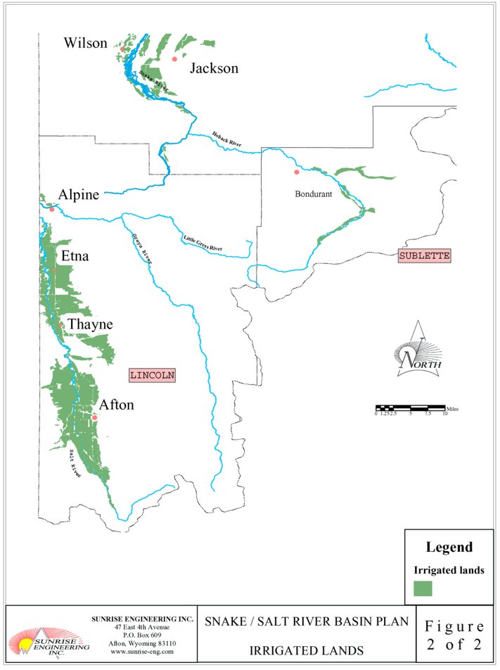
The States West mapping (see Figures 1 and 2) was overlaid on the DRG’s and each topographic map was plotted.
Water Rights Attribution
The water right attribution entails identifying and describing the water rights attached to the irrigated lands polygons. Knowing the water rights attached to the polygons provides additional understanding of the source of supply and the irrigation systems that provide water to the irrigated lands. This knowledge increases the accuracy and reliability of the service area designation used to group lands by source of supply.
Mr. Frank Carr performed water rights attribution for each identified irrigated polygon. This data was provided as an excel spreadsheet. The spreadsheet was converted to a .dbf file and joined to the irrigated lands polygon coverage thus associating the water right data with each irrigated polygon. The water right database fields include the following:
Mr. Carr has provided a brief description of water rights terminology specific to Wyoming’s water law policy and procedure (see Appendix A).
Where multiple water rights were associated with a single irrigated polygon, the irrigated lands polygons were assigned an identification number. A database for the water rights information created by Mr. Carr was created with the associated polygon numbers assigned to the water rights within each polygon (a one-to-many relationship).
The water rights attached to each individual irrigated polygon were abstracted from the original records on file in the office of the Wyoming State Engineer and State Board of Control located in Cheyenne, Wyoming.
Final GIS Products – Database
Irrigated Lands Database
All GIS coverages and data compilation was performed by Robert E. King. Mr. King is the GIS Division Manager for Sunrise Engineering, Inc.
Other fields were added to the irrigated lands coverage, including the name of the topographic quadrangle to aid in the location of the polygon. A field with a unique identifier was also added for each polygon which can be used later to link to a permit database.
Database Fields
| PolyId | Used to link to water rights |
| Facility name | |
| Source | |
| Permit Number | |
| Permit Date | |
| Type | |
| Status | |
| Permitted Area (Acres) | |
| Additional Supply Type | |
| Additional Supply Status | |
| Additional Supply Permitted Area (Acres) | |
| Permitted Amount | |
| Use | |
| HUC_Number | Hydrologic Unit Code Level 4 number |
| Reg_Name | HUC region name |
| Sub_Name | HUC subregion name |
| Acc_Name | HUC accounting name |
| Cat_Name | HUC cataloging name |
The coordinate system used will be the geographic (latitude and longitude) North American Datum (NAD) 1927. For more data information FGDC metadata has been provided for each shapefile and coverage exchange file.
Points of Diversion Coverage
In order to determine actual locations where permits divert from their source, the points of diversion (POD’s) of the active permits were mapped and used to create this GIS coverage. The POD’s with greater than 10 cfs were acquired from the State Engineers Office permit mapping and data records by Mr. Frank Carr. A database was created from this data and used to attribute the POD locations identified on USGS maps. The POD locations were extracted from the State Engineer Office records by quarter section calls.
Two GIS themes were created:
The following databases were developed:
The association database provides the information needed to link the water rights to the irrigated lands polygons and the polygons to the points of diversion.
Database Fields
| ServAreaId | Point of Diversion ID Number |
| PNT number | Point Number |
| X | X Coordinate |
| Y | Y Coordinate |
| PTCODE | Point Code Name |
| PTDESC | Point Description |
| SSnumber | Point data number |
| HUC_Number | Hydrologic Unit Code Level 4 |
| Reg_Name | HUC region name |
| Sub_Name | HUC subregion name |
| Acc_Name | HUC accounting name |
| Cat_Name | cataloging name |
Water Well Permit Coverage
Arc-Info point coverages were developed from 1999 State Engineers Office information to map all ground water wells that have a capacity over 50 gpm. The 1999 data was updated to reflect new wells from the State Engineers Office records. The data includes irrigation, industrial, and municipal wells that meet the minimum output criteria. The database fields include the permit information as stated above in the water rights attribution data. When the well location maps were unavailable, the locations of the wells were estimated from the quarter-quarter description on the well permit.
APPENDIX A
Wyoming Water Rights Terminology
Wyoming Water Rights Terminology
Surplus Water: Whenever the supply of water in a stream reaches the point where there is water available over and above the needed to fill all appropriations with a priority senior to March 1, 1945, then this stream is in surplus flow condition. When surplus flows are available, the water is to be divided proportionally among the senior rights up to an additional 1.0 cfs to every 70 acres or 1.0 cfs to every 35 acres total supply. (W.S 41-3-319-324)
Excess Water: Each water right with a priority date of post March 1, 1945 but pre March 1, 1985 is entitled to 2.0 cfs for every 70 acres before any water is made available to post March 1, 1985 water rights. If there is insufficient water to furnish 2.0 cfs to each post March1, 1945 and pre March 1, 1985 water right, but more than enough to furnish 1.0 cfs to each of these rights, the excess water is divided among those rights on a prorate basis. (W.S. 41-4-330)
Territorial Appropriation: This is an appropriation of water with a priority date prior to statehood. These rights were filed under a system of statement of claims to water under territorial law rather than a permit system. They were adjudicated after statehood by the then-established State Board of control. No permits numbers were assigned to those water rights, and they can be identified only by the proof number.
Direct Flow Appropriation: This is an appropriation of water that diverts from a surface water source and is measured in cubic feet per second (cfs). The appropriation is granted by the State Engineer and gives the appropriator the right to divert water as set out in the permit. The statutes set the amount of diversion for irrigation at a rate of 1.0 cfs for every seventy (70) acres to be irrigated. (W.S. 41-3-317)
Unadjudicated Permit: This is a permit that has not been fully perfected. It can be in the construction stage through the application of water to beneficial use. When the permit is issued by the State Engineer, the applicant is given time limits to commence construction, complete construction, and apply the water to beneficial use. While all this is taking place the permit is considered as “unadjudicated”.
Adjudicated Permit: This is a permit where the notice of completion of beneficial use has been filed, proof of appropriation prepared, a field inspection made with the finding that the facility is built within the terms of the permit, the proof advertised with no protests, and the proof considered and allowed b the State board of Control. After these items are completed, an order of the Board and the Certificate of Appropriation are prepared, issued, and recorded in the court house of the respective county and made a matter of record in the Tabulation of Adjudicated Water Rights.
Storage Right (Reservoirs): This is a permit that allows an appropriator to store or impound for beneficial purposes unappropriated water. Water can be stored for irrigation, stock, municipal, fish, recreational, and other purposes, provided that a permit October 27, 2000 Page 16 is secured from the State Engineer. Upon completion of reservoir construction, the storage right is considered as being put to beneficial use. (W.S. 41-3-301)
Secondary Application: A Secondary permit may be secured by filing with the State Engineer a secondary application solely for the purposes of attaching water stored for irrigation purposes to specific lands. The application requests that a certain number of acre-feet of stored water be allocated to specific lands. Once the application is granted, the allocated water cannot be used on any other lands or for any other purpose.
Supplemental Supply: direct flow water from a different source and different point of diversion to augment or supplement the available water for an existing appropriation (water right) for which the original source does not provide a full supply constitute a supplemental supply. The amount of supplemental water which may be diverted is the amount available, in priority, to bring the total water diverted from all sources up to the appropriated amount of 1.0 cubic foot per second (cfs) for every 70 acres to be irrigated. (W.S. 41-3-113)
Court Decrees: A small number of water rights were confirmed (adjudicated) by court decrees prior to the creation of the State Board of Control.
Original Supply Groundwater: Groundwater is appropriated in gallons per minute (gpm). Original supply is a water right attached to land or uses where there is no other water right of record. It is the first priority water right attached to and to be used on the identified land.
Additional Supply Groundwater: Additional supply is additional water to lands or uses which already have a valid existing water right. It can be additional water to surface water irrigation and/or groundwater irrigation. Additional groundwater is measured in gallons per minute (gpm).
Unadjudicated Groundwater: A valid groundwater permit (well permit) which is in the process between the issuance of the permit and completion of beneficial use, I.e., construction, pump testing, application of water to beneficial use, mapping, and filing the necessary paper work to begin the adjudication process is considered unadjudicated.
Adjudicated Groundwater: A groundwater permit (well permit) where notice of completion of beneficial use has been filed, the adjudication map prepared and filed, proof of appropriation prepared, inspected and advertised with no protests received, proof considered by the State Board of Control and allowed, Certificate of Appropriation prepared, issued, and recorded in the respective county court house is considered adjudicated. The appropriation is made a matter of record in the Tabulation of Adjudicated Water Rights.
Figure 1: Irrigated Lands, North
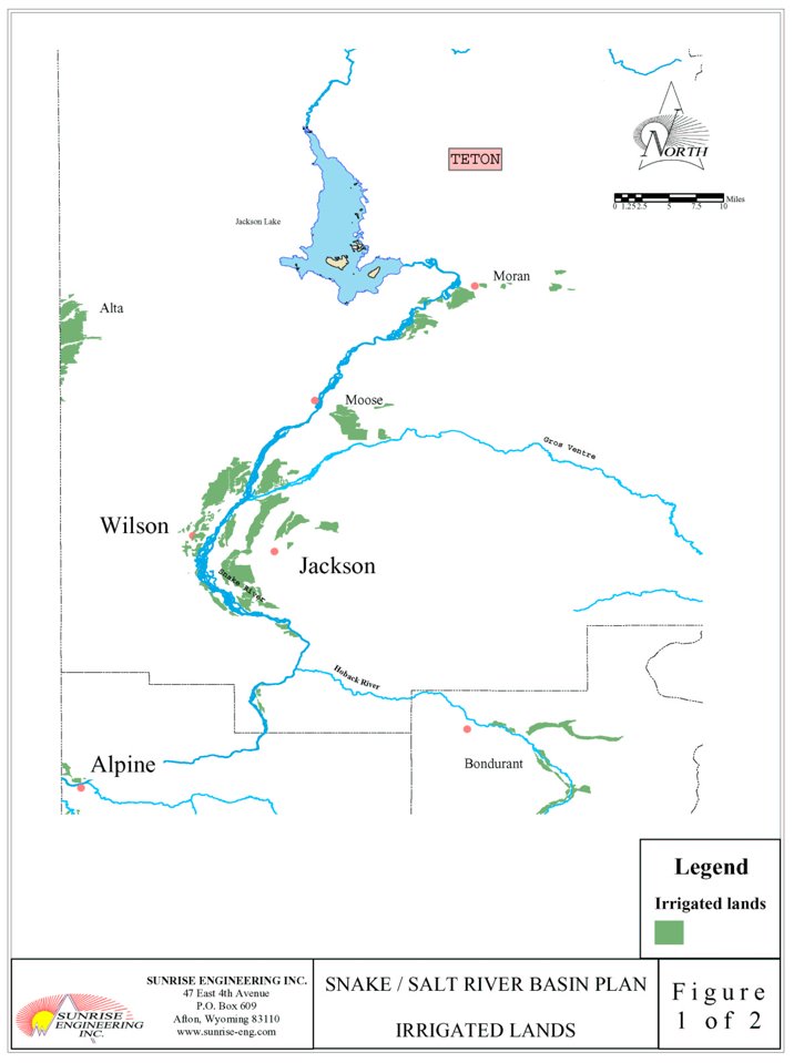
Figure 2: Irrigated Lands, South