|
| Groundwater Wells (2003) |
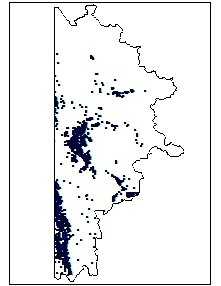 |
| Contains approximately 15,600 point locations of Wyoming well permit locations on file with the Wyoming State Engineer's Office. The wells have been located to the to the nearest 40 acre parcel. All locational information and attributes were imported from the Wyoming State Engineer's Office Well Permits Database stored in SQL-Server. |
|
| Metadata |
Scale: 1:24,000 |
Wyoming State Engineer's Office |
| Shapefile |
Compressed: 226kb |
GCS North American Datum of 1927 |
Point/Decimal Degrees |
|
| Irrigation Points of Diversion (2003) |
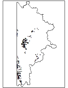 |
| This dataset contains the locations of points of diversion for the irrigated lands mapped for the Snake/Salt River Basin Plan. |
|
| Metadata |
Scale: 1:24,000 |
Wyoming State Engineer's Office |
| Shapefile |
Compressed: 24kb |
GCS North American Datum of 1927 |
Point/Decimal Degrees |
|
| Short List of Future Opportunities (2003) |
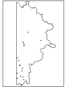 |
| Locations of Basin proposed projects |
|
| Metadata |
Scale: 1:24,000 |
Sunrise Engineering |
| Shapefile |
Compressed: 6kb |
GCS North American Datum of 1927 |
Point/Decimal Degrees |
|
| Weather Stations (2003) |
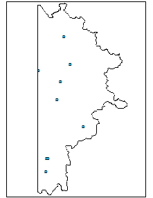 |
| The dataset's original extent, coordinate system, and data attributes have been altered. The dataset has been clipped to the extents of the Snake/Salt Basin Boundary (6th level hydrologic unit code watershed boundaries). The coordinate system has been changed to Lat/Long NAD 1927, and various data attributes have been excluded. These data alterations occurred in the Spring of 2003 for use in the Wyoming Water Development Commission's Snake/Salt River Basin Plan. |
|
| Metadata |
Scale: unknown |
Water Resources Data System |
| Shapefile |
Compressed: 15kb |
GCS North American Datum of 1927 |
Point/Decimal Degrees |
|
| Annual Precipitation (2003) |
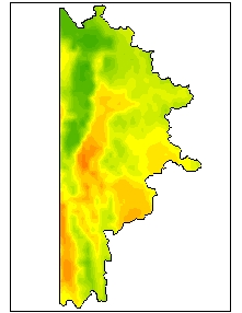 |
| This ftp site contains vector and polygon coverages of average monthly and annual precipitation for the climatological period 1961-90. Parameter-elevation Regressions on Independent Slopes Model (PRISM) derived raster data is the underlying data set from which the polygons and vectors were created. PRISM is an analytical model that uses point data and a digital elevation model (DEM) to generate gridded estimates of annual, monthly and event-based climatic parameters. Detailed descriptions of the PRISM raster data can be found with the accompanying raster data sets. For further information, the online PRISM homepage can be found at . |
|
| Metadata |
Scale: 1:250,000 |
PRISM Group |
| Shapefile |
Compressed: 403kb |
GCS North American Datum of 1927 |
Polygon/Decimal Degrees |
|
| Basin Boundary (2003) |
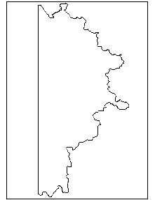 |
| This dataset contains displays the boundaries of the Snake/Salt River Basin Plan for Wyoming mapped at a 1:24,000 scale. |
|
| Metadata |
Scale: 1:24,000 |
Wyoming Geographic Science Center |
| Shapefile |
Compressed: 128kb |
GCS North American Datum of 1927 |
Polygon/Decimal Degrees |
|
| Bedrock Geology (2003) |
 |
| The geologic map was digitized from original scribe sheets used to prepare the published Geologic Map of Wyoming (Love and Christiansen, 1985), consequently at a 1:500,000 scale. The dataset has both polygon and line features (faults), with attributes derived from the 1985 map. |
|
| Metadata |
Scale: 1:500,000 |
U.S. Geological Survey |
| Shapefile |
Compressed: 698kb |
GCS North American Datum of 1927 |
Polygon/Decimal Degrees |
|
| HUC 250 Boundaries (2003) |
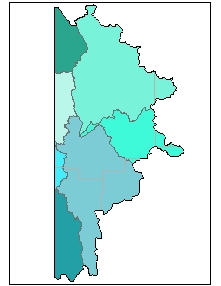 |
| The Geographic Information Retrieval and Analysis System (GIRAS) was developed in the mid 70s to put into digital form a number of data layers which were of interest to the USGS. One of these data layers was the Hydrologic Units. The map is based on the Hydrologic Unit Maps published by the U.S. Geological Survey Office of Water Data Coordination, together with the list descriptions and name of region, subregion, accounting units, and cataloging unit. The hydrologic units are encoded with an eight- digit number that indicates the hydrologic region (first two digits), hydrologic subregion (second two digits), accounting unit (third two digits), and cataloging unit (fourth two digits). The data produced by GIRAS was originally collected at a scale of 1:250,000. This data set is a modification for Wyoming of the original United States HUC data produced by the USGS. The primary modifications made in this data set by the Wyoming Water Resources Center include 1) removal of hydrologic units that do not drain within Wyoming and 2) modification of the hydrologic unit boundaries to better encompass streams and lakes represented in the 1:100,000 scale Digital Line Graph (DLG) of surficial hydrography. This metadata has also been altered from original USGS metadata to be more specific for Wyoming. |
|
| Metadata |
Scale: 1:250,000 |
U.S. Geological Survey |
| Shapefile |
Compressed: 112kb |
GCS North American Datum of 1927 |
Polygon/Decimal Degrees |
|
| Irrigated Lands (2003) |
 |
| This data set is a polygon coverage. It only contains irrigated acreage in the Snake/Salt River basin within Wyoming. The interpretation of irrigated lands due to the works of man was taken from 1982 and 1983 aerial infra-red photos. Upon completion of digitizing these areas, Wyoming State Engineer's Office field personnel updated the lands and checked the accuracy of the delineation. The data structure for this data set is based on graph theory, in which a two-dimensional diagram is expressed as a set of spatial objects in a manner that explicitly expresses logical relationships. Applied to a map, this concept is used to encode the spatial relationships between the objects, including such concepts as adjacency and connectivity between objects. A topologically structured data file can support graphic applications, as well as computations and analyses involving the spatial objects and their spatial relationships. |
|
| Metadata |
Scale: 1:24,000 |
States West Water Resources Corporation |
| Shapefile |
Compressed: 45kb |
GCS North American Datum of 1927 |
Polygon/Decimal Degrees |
|
| Major Lakes (2003) |
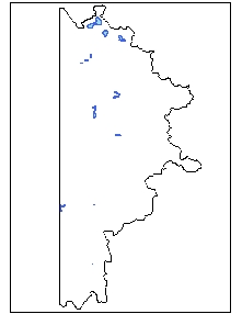 |
| Hydrographic features for Wyoming at 1:100,000-scale, including perennial and intermittent designations and Strahler stream order attributes for streams. Does not include man-made ditches, canals and aqueducts. The data was originally produced by USGS, a Digital Line Graph (DLG) product, though this product was enhanced (edgematched, some linework and attributes corrected, stream order attribute added). A subset of this dataset is also available for distribution, including only major streams (order 4 to 7) and major lakes and reservoirs. In order to reduce the size of this subset, the line segments were dissolved to remove unncessary segments. Both datasets are available in Arc export file and shapefile format for download (see Onlink_Linkage) Statewide and tiled data: there is one export file, which when imported into ARC/INFO, will contain one coverage with both polygon (lakes, reservoirs) and line (streams) topology and two feature attribute files (.PAT and .AAT) along with three additional attribute files containing descriptive information. In shapefile format, there will be two shapefiles (polygons and lines separated), with all attribute files in Dbase format. |
|
| Metadata |
Scale: 1:100,000 |
Wyoming Geographic Science Center |
| Shapefile |
Compressed: 190kb |
GCS North American Datum of 1927 |
Polygon/Decimal Degrees |
|
| Major Reservoirs (2003) |
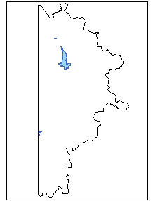 |
| Hydrographic features for Wyoming at 1:100,000-scale, including perennial and intermittent designations and Strahler stream order attributes for streams. Does not include man-made ditches, canals and aqueducts. The data was originally produced by USGS, a Digital Line Graph (DLG) product, though this product was enhanced (edgematched, some linework and attributes corrected, stream order attribute added). A subset of this dataset is also available for distribution, including only major streams (order 4 to 7) and major lakes and reservoirs. In order to reduce the size of this subset, the line segments were dissolved to remove unncessary segments. Both datasets are available in Arc export file and shapefile format for download (see Onlink_Linkage) Statewide and tiled data: there is one export file, which when imported into ARC/INFO, will contain one coverage with both polygon (lakes, reservoirs) and line (streams) topology and two feature attribute files (.PAT and .AAT) along with three additional attribute files containing descriptive information. In shapefile format, there will be two shapefiles (polygons and lines separated), with all attribute files in Dbase format. |
|
| Metadata |
Scale: 1:100,000 |
Wyoming Geographic Science Center |
| Shapefile |
Compressed: 87kb |
GCS North American Datum of 1927 |
Polygon/Decimal Degrees |
|
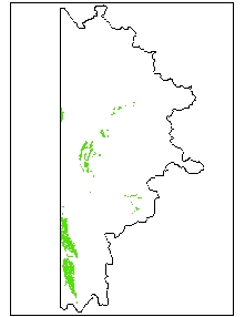
| National Wetlands Inventory (2003) |
 |
| Original digital National Wetland Inventory digital line graphs, source scale approximately 1:24,000, converted into Arc/Info coverages with matching attributes. See graphic image or on-line linkage for availability of these quadrangles in Wyoming. |
|
| Metadata |
Scale: 1:24,000 |
U.S. Fish and Wildlife |
| Shapefile |
Compressed: 10,706kb |
GCS North American Datum of 1927 |
Polygon/Decimal Degrees |
|
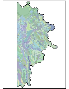
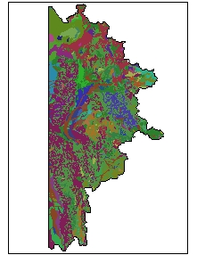
| Soils (2003) |
 |
| This dataset represents soils of Wyoming at 1:500,000- scale. The layer contains 45 separate soils descriptions across 10 Wyoming soil zones. The layer was compiled based on the five-factor soil forming model using digital surficial geology, bedrock geology, and elevation. This dataset is documented in the report: Munn, L.C. and C.S. Arneson, 1998. Soils of Wyoming: A Digital Statewide Map at 1:500,000-Scale. Agricultural Experiment Station Report B-1069. University of Wyoming, College of Agriculture, Laramie, Wyoming. |
|
| Metadata |
Scale: 1:500,000 |
University of Wyoming |
| Shapefile |
Compressed: 2,913kb |
GCS North American Datum of 1927 |
Polygon/Decimal Degrees |
|
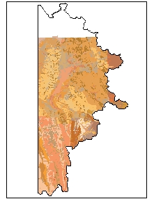
| Surficial Geology (2003) |
 |
| This dataset represents surficial geology of Wyoming at 1:500,000-scale. The layer contains 577 separate surficial feature (landforms) and deposit descriptions present on the surface in the state. Compiled from aerial photography and existing maps this layer represents the first comprehensive surficial geology map of Wyoming. |
|
| Metadata |
Scale: 1:500,000 |
Wyoming State Geological Survey |
| Shapefile |
Compressed: 3,509kb |
GCS North American Datum of 1927 |
Polygon/Decimal Degrees |
|
| Faults (2003) |
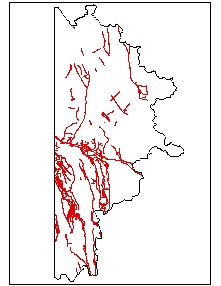 |
| Data was digitized from original scribe sheets used to prepare the published Geologic Map of Wyoming (Love and Christiansen, 1985), consequently at a 1:500,000 scale. |
|
| Metadata |
Scale: 1:500,000 |
U.S. Geological Survey |
| Shapefile |
Compressed: 146kb |
GCS North American Datum of 1927 |
Polyline/Decimal Degrees |
|
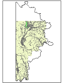
| Major Streams (2003) |
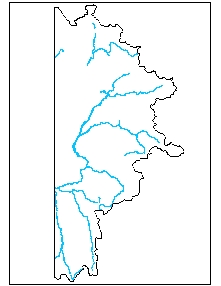 |
| Hydrographic features for Wyoming at 1:100,000-scale, including perennial and intermittent designations and Strahler stream order attributes for streams. Does not include man-made ditches, canals and aqueducts. The data was originally produced by USGS, a Digital Line Graph (DLG) product, though this product was enhanced (edgematched, some linework and attributes corrected, stream order attribute added). A subset of this dataset is also available for distribution, including only major streams (order 4 to 7) and major lakes and reservoirs. In order to reduce the size of this subset, the line segments were dissolved to remove unncessary segments. Both datasets are available in Arc export file and shapefile format for download (see Onlink_Linkage) Statewide and tiled data: there is one export file, which when imported into ARC/INFO, will contain one coverage with both polygon (lakes, reservoirs) and line (streams) topology and two feature attribute files (.PAT and .AAT) along with three additional attribute files containing descriptive information. In shapefile format, there will be two shapefiles (polygons and lines separated), with all attribute files in Dbase format. |
|
| Metadata |
Scale: 1:100,000 |
Wyoming Geographic Science Center |
| Shapefile |
Compressed: 1,221kb |
GCS North American Datum of 1927 |
Polyline/Decimal Degrees |
