Wyoming State Water Plan
Wyoming State Water Plan
Wyoming Water Development Office
6920 Yellowtail Rd
Cheyenne, WY 82002
Phone: 307-777-7626

Wyoming Water Development Office
6920 Yellowtail Rd
Cheyenne, WY 82002
Phone: 307-777-7626


|
BBC Consulting, Inc. Denver, CO 80209 | Boyle Engineering, Inc. Lakewood, CO 80228 |
|
Hinckley Consulting Laramie, WY 82070 | Fassett Consulting Cheyenne, WY 82003 |
|
Rendezvous Engineering Jackson, WY 83001 | Nelson Engineering Jackson, WY 83001 |
A. INTRODUCTION
The 2001 Wyoming Legislature authorized the Wyoming Water Development Commission (WWDC) to complete the Snake/Salt River Basin portion of the State Water Plan. According to the WWDC, the river basin planning process has the following goals:
As part of the initial planning process, the WWDC decided to construct a set of guidelines for the various plan components in order to promote consistency among the various basin plans. A document entitled "State of Wyoming Water Basin Planning Process, Guidelines for Development of Basin Plans" was created in 2001 by the WWDC and States West Water Resources Corporation. The consultant team utilized these guidelines during creation of the Snake/Salt River basin plan. The following topics are included in the Snake/Salt River basin plan:
Numerous technical memoranda were created as the background to this final report. All topics discussed in this report are covered in detail in the technical memoranda. These documents, as well as other Wyoming river basin plans, can be found electronically on the Wyoming State
Water Plan homepage at http://waterplan.state.wy.us/. For practical purposes, all references used in the creation of this report can be found in its corresponding technical memorandum.
The initial Snake/Salt River Basin Advisory Group meeting was held May 15, 2001 in Jackson. At that time the Basin Advisory Group (BAG) was formed, consisting of over 30 citizens from throughout the basin. The members represent a variety of interests, such as agriculture, industry, environmental, government and recreation. Their knowledge and input was invaluable to the creation of this basin plan and their efforts were much appreciated.
B. DESCRIPTION
Location:
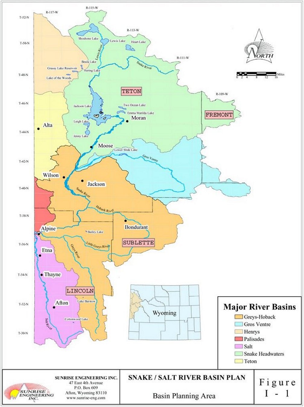
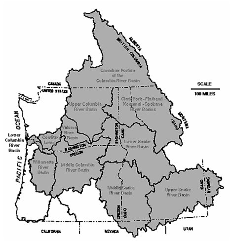
The Snake River Basin is part of the Columbia River drainage that flows to the Pacific Ocean. The Snake/Salt River basin in Wyoming is a portion of the headwaters of the Snake River, and contains all of the Snake Headwaters, Gros Ventre, Greys, and Hoback sub-basins, as well as portions of the Salt, Palisades, Teton, Lower Henry's, and Upper Henry's sub-basins. The Wyoming portion of the Snake/Salt River basin covers approximately 5,100 square miles. A map of the Snake/Salt River basin planning area can be found in Figure I-1. The Snake River is one of the major rivers of the West, flowing from Wyoming across Idaho before converging with the Columbia River in Washington. The basin covers all of Teton County and portions of Lincoln, Sublette, and Fremont Counties. The basin includes all of Grand Teton National Park, as well as a portion of Yellowstone National Park.
Topography:
The basin is quite mountainous, with populated areas located mainly in the larger valley locations. The main stem of the Snake River flows generally north to south, while the tributaries flow in varied directions prior to meeting the Snake. The Salt River runs primarily south to north. The Snake, Salt, and Greys Rivers converge at Palisades Reservoir, which is located on the Wyoming-Idaho border.
The west slope of the Teton Range flows to the west toward the Henry's Fork of the Snake River and its tributary, the Teton River. The Henry's Fork merges with the main stem of the Snake River downstream in Idaho. Elevation of the basin ranges from the Grand Teton at 13,770 feet to Palisades Reservoir at 5,500 feet.
Climate:
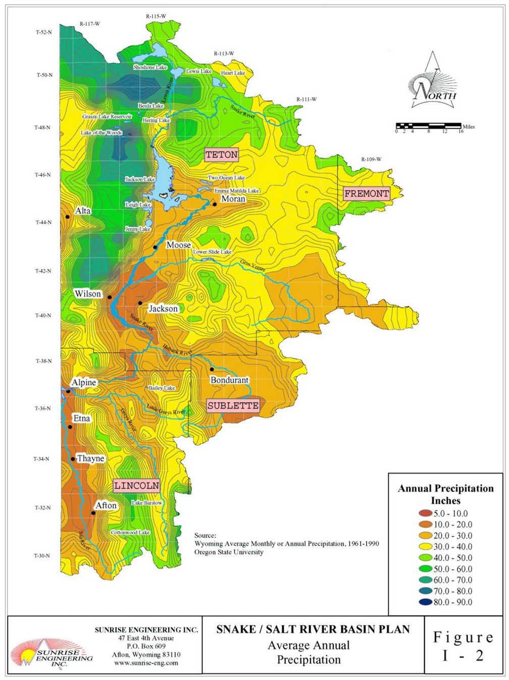
Climate in the basin can be quite variable due to the range of elevation that is present. Of the locations with recorded data, the average annual precipitation ranges from approximately 17 inches in Jackson to over 28 inches at the Snake River site near Flagg Ranch. Examples of precipitation at other populated areas include over 18 inches at Afton, nearly 24 inches at Alta, and over 20 inches at Boundurant. Mountainous areas typically have much higher average annual precipitation, with some areas at over 60 inches in areas of the Tetons. The majority of the precipitation falls in the winter as snowfall, which then melts and flows as runoff during the spring and summer months. The average annual precipitation across the basin is shown in Figure I-2.
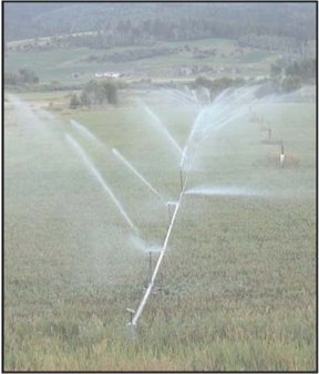
The high elevation of the mountain valleys in the basin results in a fairly short growing season capable of supporting only native hay, alfalfa, and small grains. The average growing seasons are 139 days and 144 days for Jackson and Afton respectively. Also, the relative lack of precipitation during the summer results in a need for crop irrigation in order to maximize crop production.
Water Features:
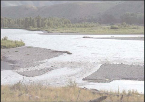
The main water features in the Snake/Salt River basin are the rivers themselves. The Snake River is the largest in the basin, and its sizeable tributaries include the Buffalo Fork, Gros Ventre, and Hoback Rivers. The Salt and Greys Rivers are also tributary to the Snake, and join the main river at Palisades Reservoir. Numerous streams feed each of these rivers on their journey through the basin.
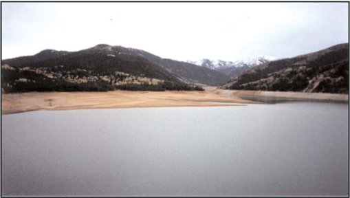
There are many natural lakes in the basin, which include Shoshone, Heart, and Lewis Lakes in Yellowstone National Park. There are many sizeable lakes in Grand Teton National Park, including Jackson, Jenny, Leigh, Two Ocean, and Emma Matilda Lakes. Many smaller lakes are located throughout the basin, generally on Forest Service lands. There are few major reservoirs in the basin. The major reservoirs are Jackson Lake, Grassy Lake, and Palisades Reservoir. These three features are managed by the U.S. Bureau of Reclamation.
History:
Prior to the early 1800's, the Snake/Salt River basin was frequented by Sioux, Blackfeet, Gros Ventre, Crow, and Shoshone tribes for hunting during the warmer months. The area was not used for year-round habitation due to the harsh winters.
Fur trappers began to frequent the area in the early 1800's. It is believed that John Colter first visited the Jackson Hole area in 1807 and eventually traveled through the Yellowstone Park area. Many famous trappers worked in the area, such as Jedediah Smith, Jim Bridger, and Davey Jackson, after which Jackson Hole was named. The mountain men annually held a rendezvous in the summer. By 1840, the fur trade had virtually ended, and the area was again left unsettled and visited only occasionally.
The area was acquired by the United States as part of the Oregon Territory in 1846. Many travelers passed through the Star Valley area on the Lander Trail, a cut-off from the original Oregon Trail, from 1856 until the late 1860's. However the area didn't see permanent settlers until the late 1870's to mid 1880's. With settlement, the livestock industry began to grow, and by the 1890's dairy production had begun in the Star Valley area.
C. WATER RELATED HISTORY OF THE BASIN
The Wyoming Territorial Legislature adopted laws regarding the appropriation of irrigation water in 1886. In 1889, the Constitutional Convention established water law under which the state had control of the water. These laws were in place as Wyoming achieved Statehood in 1890. While water was undoubtedly used previously for irrigation purposes, the first approved water right in the Star Valley area was in 1885 on Spring Creek, a tributary of Crow Creek. Rights were filed on many of the tributaries and rivers in the basin soon afterward.
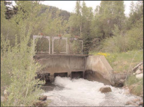
Irrigation developed more rapidly downstream in Idaho due to the longer growing season and rich soils. A rock filled crib dam was initially constructed on Jackson Lake in 1907, which was replaced by a concrete dam in 1911. The dam height was increased to its current level by 1916. Additional reservoirs were later constructed for the benefit of Idaho irrigation, with Grassy Lake Reservoir in 1939 and Palisades Reservoir in 1957.
Due to the increase in water use in Idaho, conflicts arose between Idaho and Wyoming regarding the use of water. These conflicts resulted in the Roxanna Decree in 1941, which governs the use of Teton Creek and South Leigh Creek on the west side of the Teton Range. Soon afterward in 1950 the Snake River Compact was agreed upon by the two states as well as by federal agencies. Gravity flow sprinkler systems were established in many areas of Star Valley in the 1960's and 1970's. This resulted in an increase of productivity of the farmland under sprinkler irrigation. Only isolated areas in the Jackson Hole area have converted to sprinkler irrigation, and many continue with flood irrigation to keep the Old West atmosphere. Also, some formerly irrigated areas have been converted into residential subdivisions.
There is very little use of stored water for irrigation within the Snake/Salt River basin. The large reservoirs located in the basin, Jackson Lake and Grassy Lake, store water for use on farmland located downstream in Idaho.
D. WYOMING WATER LAW
One of the primary tenets established in the Wyoming Water Development Commission water planning process is that Wyoming water law would be respected in all aspects throughout the process. Wyoming water law is the foundation upon which all water use, development and protection is based; it provides the predictable basis upon which existing use and future planning and investment in the State's most valuable and renewable resource are made. The water rights system in Wyoming is administered by the State Engineer's Office and State Board of Control, both constitutionally-based administrative and quasi-judicial entities of state government.
Wyoming's water laws have evolved from the early establishment of legal principles that were later embodied in our state's Constitution and a series of statutory laws written and adopted early in Wyoming's history that have stood the strong test of time and certainty. One early water dispute that involved two territorial pioneers, William McCrea and Charles Moyer, is instructive regarding the history of water law in Wyoming. Moyer, whose name is associated with a now-famous spring in the coal-mining region north of Gillette, developed that spring for irrigation in 1890. Previously, Mr. McCrea developed an irrigation project along the Little Powder River downstream of, and partially supplied by, Moyer's spring. With Moyer's development, McCrea's ditch was now short of water and the resulting argument was eventually elevated to the Wyoming Supreme Court. In one of the first Court rulings on water matters, the Court affirmed the "first in time, first in right" doctrine by siding with McCrea. Through this 1896 ruling, the Supreme Court recognized the concepts of the prior appropriation doctrine that Territorial Engineer Elwood Mead had been advocating throughout his early tenure in the days leading to statehood and the constitutional conventions.
As Engineer for the Territory of Wyoming, and later its first State Engineer, Mead understood that water, in an arid region, must be administered in a predictable and equitable fashion, and the methods he was fostering were to allow the earlier developer of water to establish the senior right for its continued use. The Wyoming State Constitution, in Article VIII, adopted this priority system of appropriation and established the position of State Engineer. Through the efforts of Mead, the Constitution also embodied the basis of appropriating water on the concept of "beneficial use" to avoid the potential for greatly exaggerated amounts of water being tied up needlessly by early settlers and developers of water diversion systems. Mead was also at the forefront of affirming a strong and active state role, as an independent, responsive and unbiased decision-maker, in all aspects of appropriating and administrating the waters of the state. In this light, Mead was also the architect of the process for resolving of water disputes. Rather than use a water court system as in the neighboring state of Colorado, Wyoming established the State Board of Control within its Constitution. In addition to its independent authority to review matters initially decided by the State Engineer, the Board of Control is the adjudicator of all water rights and the decision-maker of all requests for changes to water rights. The Constitution declares all water in the state to be the property of the state, subject to appropriation for beneficial use through the administrative permitting of water rights. Water rights are considered property rights that attach to the land or place of use. Yet, the law provides that the owner of these rights may change the location of use, or the type of use, by seeking approval of a change or modification to the water right from the Board of Control. The final decisions of the Board of Control are subject to judicial review. The Board of Control is made up of the State Engineer and the four Water Division Superintendents.
Within this constitutional framework, the detailed statutory authority, procedures, and administration were further defined by legislation and periodic Court decisions. The State Engineer's role is defined in Title 9, Chapter 1, Article 9, along with the general authority to establish fees for certain services and some other minor activities of the agency. The majority of Wyoming's water laws are now codified primarily in Title 41 of Wyoming Statutes, entitled "Water".
Under this title, there are fourteen chapters that now include the authority and activities of the Water Development Commission and the laws associated with irrigation, drainage, watershed improvement, and water and sewer districts. Several chapters also address interstate compacts, described elsewhere in this basin plan, and the use of watercraft. Chapters 3 and 4 contain the important laws relating to the appropriation, administration and adjudication of water rights in Wyoming. These statutes provide the detailed authorities and procedures for the State Engineer and Board of Control as they relate to their respective responsibilities for the general supervision of the waters of the state, whether they be from surface streams, springs, natural lakes or underground waters.
The key elements of Wyoming's water laws were established in the Constitution and the early statutory laws before and near the turn of the century. From time to time, the legislature has judiciously and periodically modified this longstanding body of law to address emerging new issues of the water users in the state. The laws addressing reservoirs were passed in the early 1900's; laws specific to ground water sources were introduced in the 1940's and 1950's, with the last significant change adopted in 1969. Recently, laws addressing instream flow water rights were codified in 1986. The basic framework of water right permitting actions and administration has remained the same, all the while allowing for flexibility in answering the needs of water users and subject to selective statutory changes that address emerging concerns regarding the beneficial use of water. That is why this set of laws is a part of the principles upon which the Snake/Salt River Basin Plan is based.
E. INTERSTATE COMPACTS
Wyoming is a headwater state; its mountain ranges are often the highest elevation source of water for many of the most significant rivers in the western United States. Wyoming straddles a portion of the continental divide and is a primary contributing source of water to the Colorado River (via the Green, Henry’s Fork and Little Snake Rivers), the Missouri River (via the Clarks Fork, Big Horn/Wind, Powder, Tongue, Belle Fourche, Cheyenne, Niobrara, North Platte, South Platte and Laramie Rivers), Great Salt Lake Basin (vis the Bear River) and the Columbia River (via the Snake and Salt River); the basins of interest in this river basin plan. As such, the waters originating in Wyoming are shared by water users in many surrounding downstream states.
As a result of more rapid development and population growth in downstream states, an upstream state is critically interested in protecting its long-term right and ability to develop the waters of a shared interstate river, for the future. Soon after the turn of the century, upstream states were concerned that the "first in time, first in right" doctrine, uniformly adopted for intrastate distribution of water, would be applied across state lines to the detriment of "junior" or later developing upstream water uses. To address these concerns and circumstances, legal processes were established over the past ninety years to provide for the orderly allocation and protection of the use, rights and privileges of the waters of streams and rivers that flow across state lines.
There are two basic ways the rights and allocations of water sources shared between states are established. The first is a result of litigation between states that is resolved by a decree of the Courts of the United States that equitably apportions the shared water resources between the states. The second way is established cooperatively through an interstate compact, which is an agreement between the participating states, with the consent of Congress, dividing the waters of an interstate stream. Wyoming has many such arrangements for the interstate rivers and streams leaving our borders, including the Snake and Salt River basins. The rights of Wyoming and Idaho to the waters of Teton Creek and South Leigh Creek, on the west side of the Teton Mountain Range, have been settled by a decree of the District Court of the United States for the District of Wyoming, and the rights to the waters of the Snake and Salt River watersheds are included in the Snake River Compact. Both of these important documents are discussed herein.
The primary purpose of an interstate compact or a decree of the Court is the equitable division or apportionment of stream flow among participating states. These legal protections provide the long-term certainty of access to the available water resources for the slower developing state and the security for the downstream state that all of the upstream resources will not be depleted. Often, the basis for the division is the amount of historic and potential future use of water in the river basin of interest, but of course, there is no hard rule to follow in a negotiated agreement. An integral part of these documents or decisions is also the method of measurement or accounting of the agreed allocations of water. Often, this is an amount of consumptive use for a variety of beneficial purposes or a percentage of available water supply at a designated point of measurement.
The Snake River Compact:
Congress, by the Act of June 3, 1948, provided their consent to Wyoming and Idaho negotiating a compact over the waters of the Snake River. The Snake River Compact, negotiated by the representatives of both states with participation of a representative of the United States, was signed on October 10, 1949. The compact divided the waters of the Snake and Salt River watersheds between the states of Idaho and Wyoming. This agreement was subsequently ratified by the State of Idaho on February 11, 1950, by the State of Wyoming on February 20, 1950 and by an act of Congress on March 21, 1950.
The compact recognizes, without restriction, all existing water rights in Wyoming and Idaho established prior to July 1, 1949. It permits Wyoming unlimited use of water for domestic and stock watering purposes, providing stock water reservoirs shall not exceed 20 acre-feet in capacity. The compact allocates to Wyoming, for all future uses, the right to divert or store 4% of the Wyoming-Idaho state line flow of the Snake River. Idaho is entitled to the remaining 96% of the flow. The use of water is limited to diversions or storage within the Snake River drainage basin unless both states agree otherwise. The compact also provides preference for domestic, stock and irrigation use of the water over storage for the generation of power.
The historical perspective of this seemingly "un-equitable" division of water, was the fact that the majority of the existing and potential future use of water was in Idaho. In 1949, the lack of arable land for irrigation and the high percentage of federal land (national parks, national forests and wildlife reserves) in the Wyoming portion of the basin, were factors in the negotiations. As documented in this planning report, Wyoming's demands for water have, even after 50 years, been well within the allocations provided the state under the compact.
One unique aspect of the Snake River Compact, compared to other compacts to which Wyoming is a party, is a requirement that calls for Wyoming to provide Idaho replacement storage for one-third of any usage after the first 2% is put to beneficial use. Early estimates of these replacement storage quantities, based upon the average state line flow, are 33,000 acre-feet. A valuable technical result, provided in Chapter III of this planning report, is the update of Wyoming's current use of water in the basin. This will provide the state and water users with an important component of information for future development and project planning.
The Roxanna Decree:
The Roxanna Decree is a shorthand name for a United States District Court decision resolving an interstate dispute between water users in Wyoming and Idaho diverting from Teton Creek and South Leigh Creek. The District Court for the District of Wyoming docket Equity No. 2447, Roxanna Canal Co., a Corporation, et al. v. Daniels, et al. entered its decision and decree on February 4, 1941. This decree adopted a stipulation of agreement entered into by the water user parties to the case located within Wyoming and Idaho, dated March 20, 1940.
The stipulation generally sets forth that Wyoming water users shall be unlimited in their diversions from Teton Creek and its tributaries until the measured flow of the creek diminishes to 170 cubic feet per second (cfs). After that, the Wyoming water users are limited to a diversion of 1 cfs for each 50 acres of irrigated land. When the flow further reduces to 90 cfs, the flow of Teton Creek and its tributaries is divided equally between the Wyoming and Idaho water users.
For South Leigh Creek, the stipulation generally provides the appropriators in Wyoming the unlimited diversion of water from South Leigh Creek until the natural flow of the creek diminishes to a total of 16 cfs, after which time the Wyoming water users are permitted to divert one-half of the streamflow and Idaho water users can divert the balance.
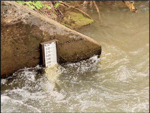
The decree provides for the installation and use of proper measuring devices in canals and along the stream as needed for the administration of the decree by the Wyoming and Idaho water officials in each state. The stipulation and decree also specify certain details for the handling of several named irrigation canals and other local implementation matters.
F. PALISADES RESERVOIR CONTRACT
While the initial Congressional authorization for the Bureau of Reclamation (Bureau) projects in the Snake River basin was provided in 1904, the series of reservoir and irrigation canal projects developed over a number of years. In response to the drought of the 1930's additional pressure for reservoir development occurred. After the requisite planning and technical analyses and enactment of the negotiated 1949 Snake River Compact by Congress, on March 21, 1950 the Bureau received specific Congressional authorization for the Palisades Dam and Reservoir project on September 30, 1950. In 1951 the Bureau began construction of the Palisades Reservoir project, which was completed in 1957. During the early planning and development efforts the Bureau administratively reserved a portion of the storage space in Palisades Reservoir as a source of the replacement storage space for Wyoming's obligations, pursuant to the Compact.
As a partial result of the dry sequence of streamflow years beginning in 1988, and continuing through to 1990, the State of Wyoming became more actively involved in the operations of the set of reservoirs in the Upper Snake River basin, including Jackson Lake and Palisades. These facilities and others are owned and managed by the Bureau in close cooperation with the Idaho water right administration officials, the Water District No. 1 Watermaster. Initially, pressure from the fishery and recreation interests in Teton County focused important attention on the Bureau's reservoir operations under these low streamflow conditions and the dramatic impacts upon the river resources and the valuable tourism and recreation segments of the local economy. One realization resulting from detailed river operation inquiries was the fact that neither the State of Wyoming nor our water users had a firm stake in any portion of the extensive storage water supplies that dominate the basin. Indeed 100% of the storage water in Jackson Lake and Palisades Reservoir was controlled by the Bureau and under contract with water users in Idaho. During normal or average year streamflow conditions this arrangement had been satisfactory, however when the river system is stressed by drought, many Wyoming residents felt their interests were discounted and not considered an important factor in planning and influencing Bureau reservoir operation decisions.
For Wyoming, several important results were derived from the increased attention by the State through the State Engineer's Office and Wyoming Game and Fish Department. These were 1) the re-discovery of the storage space set aside by the Bureau in Palisades Reservoir and 2) a change in procedures by the Bureau to actively consult with and involve the State agencies, local environmental, fishing and recreation interest groups and the public at large in the annual reservoir and river operation planning for the upper Snake River basin. These changes took place over several years, but were prompted by the State of Wyoming deciding to engage in the successful negotiation of a contract with the Bureau for the "reserved storage space" in Palisades Reservoir. At that point, the State became a "spaceholder" and a more direct player in the reservoir and river operations like other downstream water users in this river system.
As a result of evaluation and involvement with the reservoir and river operations, use of storage space set aside by the Bureau soon became the State's primary opportunity for addressing several important issues in the Snake/Salt River basin. First, the quantity of storage space "reserved" by the Bureau was the amount estimated to be required to meet Wyoming's compact replacement storage space obligations. By securing the replacement storage space Wyoming would assure its long-term ability to continue to develop and beneficially use the waters allocated from this river basin. Secondly, by holding a contract for storage space in the Bureau reservoir system, through an exchange of storage water between Palisades and Jackson Lake reservoirs, the state could also provide water or protection for the minimum river flow regime below Jackson Lake Dam and for the maintenance of higher levels in Jackson Lake during periods of drought.
To accomplish these dual benefits, the State initiated the negotiation and contracting process with the Bureau to obtain control over the "set aside" storage space in 1988 and eliminate any other potential water user from obtaining this water resource. On July 13, 1989 the Commissioner of the Bureau of Reclamation approved the "basis of negotiation", an internal Bureau document authorizing the regional representatives to move forward with the detailed negotiations. The Bureau entered the final contract, through then Regional Director John Keys (now the Commissioner of the Bureau) with Governor Mike Sullivan on behalf of the State of Wyoming effective October 31, 1990.
In summary, the contract provides Wyoming with 33,000 acre-feet (AF) or 2.75% of the 1,200,000 AF of active storage space in Palisades Reservoir. Wyoming is entitled to the water accruing to this space in priority for a variety of purposes, including the compact replacement storage space obligations, subcontracting the use of storage water to others and to maintain instream flows and lake levels within Wyoming, through an exchange. Wyoming is contractually treated for the most part like any other storage spaceholders in Palisades Reservoir under contract with the Bureau, with the same general rights and obligations for the use, accounting, and administration of the storage space.
Under the spaceholders contract Wyoming agreed to pay a proportion of the Bureau's (federal) construction costs allocated to irrigation and a corresponding share of the interest during construction for the 33,000 AF (2.75%) of Palisades Reservoir storage space. This amount totaled $567,270, which was appropriated from the water development fund by the Wyoming legislature during the 1991 session. In addition, Wyoming will annually pay a proportion (2.75%) of the operation and maintenance (O&M) costs associated with Palisades Reservoir. A capital account called a "sinking fund" was established within the State Treasurer's accounts, which is administered by the Wyoming Water Development Commission (WWDC), with a deposit of funds from the Wyoming Game and Fish Department. The interest accruing to this fund is used by the WWDC to annually pay the O&M obligations to the Bureau.
The amount of replacement storage space is determined based upon the provisions of Article III A of the Snake River Compact. Under the Compact, 4% of the waters of the Snake River basin (including the Greys and Salt Rivers) are allocated to Wyoming for direct diversion or storage. The first half or 2% of the compact allocation can be diverted or stored without any storage space replacement requirement. Wyoming shall provide replacement storage space equal to one-third of any additional use under the second half of the 4% allotment. It is estimated that Wyoming's 4% share at the Wyoming-Idaho border is approximately 200,000 AF (5,000,000 AF X 4%). One-half is approximately 100,000 AF and one-third of this amount is 33,000 AF of storage space. This was the amount "set aside" by the Bureau and, in 1990 placed under contract with Wyoming.
The estimate of current use within Wyoming outlined in this plan indicates that Wyoming is using less than the first 2% and as such, at this time the state has no compact requirement for this storage space. As growth and the demand for water increases in the basin under the terms of the Snake River Compact, this storage space will be incrementally used to meet the compact obligations to the State of Idaho. Since the potential for developing new replacement storage in the Snake River basin is limited, it was uniquely beneficial for the State to contract for the 33,000 AF of existing space available in Palisades Reservoir. Until the need for replacement storage arrives Wyoming can use the storage space for other authorized and beneficial purposes. As mentioned previously, to protect the important instream values of the Snake River between Jackson Lake and Palisades Reservoirs and the reservoir level at Jackson Lake, Wyoming's contract provides the opportunity to exchange the purchased Palisades storage for an equal amount of storage water in Jackson Lake under contract to others. Since all of the space and water contracts in Jackson Lake are held by irrigation users in Idaho, the opportunity to exchange (make an accounting trade) the storage water held by Wyoming for an equal amount held by downstream Idaho irrigation districts exists. Operationally, it makes no difference to the Idaho irrigators where the irrigation water is derived, as long as they receive their proper contractual amount. Under this alternative, at Wyoming's discretion and based on water availability, Wyoming has the option to exchange the Palisades water upstream to Jackson Lake, and use the Wyoming water to help maintain higher lake levels or to release the water to satisfy the instream flow needs along the Snake River during low streamflow periods. These Wyoming releases would supplement the minimum releases provided by the Bureau. These low streamflow circumstances generally occur during the non-irrigation season.
Figure I-1: Basin Planning Area
Figure I-2: Average Annual Precipitation