| |
|
|
| |
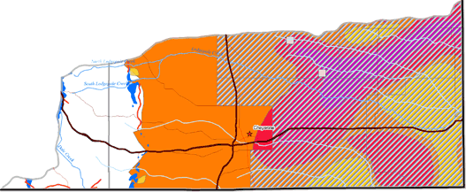
South Platte River Subbasin Future Groundwater Development Potential
|
|
| |
Depending upon the type of groundwater use and desired well water quality and quantity, the aquifer systems have potential for future development in the subbasin. A map of potential groundwater development sites for the South Platte River subbasin area is shown below. Following is a summary of the future development potential of the major aquifer systems located within the South Platte River subbasin:
-
The
Quaternary Aquifer System has historically yielded large quantities of groundwater to wells, but its development potential is limited due to its minor areal extent, existing development, and Laramie County Control Area limitations.
-
The
Late Tertiary Aquifer System has been developed for irrigation, domestic, industrial, municipal, and stock supplies in the subbasin, and despite its current level of use, appears to have future development potential for additional supplies, dependent upon existing users and determinations by Laramie County Control Area management.
-
The
Late Paleozoic Aquifer System has been identified as a potential source for future groundwater development. Development of this aquifer system will require a site-specific hydrogeologic investigation prior to well drilling to assess development potential.
|
|
|