| |
|
|
| |
Agricultural Water Use: Major Diversions

|
|
| |
Collection of information regarding Platte River Basin diversions included photographing selected diversion structures and tabulating Wyoming State Engineer’s Office (SEO) permit information regarding these structures. Major diversions were generally those that are permitted by the SEO to convey 50 cubic feet per second (cfs) or greater flow and were identified by a process including assessing an SEO database of basin diversion information, discussions with SEO hydrographers, and review of the 1999 Tabulation of Adjudicated Surface Water Rights of the State of Wyoming. The advice and assistance of SEO hydrographers, both in the office and in the field, was essential to the successful completion of this work. Some major diversions were not photographed, due either to private property access issues or very remote locations. Click here to view a map of the major diversions that were photographed in the Pathfinder to Guernsey subbasin. Following are diversion photographs and accompanying information for the Pathfinder to Guernsey subbasin.
|
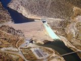
Alcova Powerplant |
Structure number |
PG-1 |
Wyoming State Engineer’s Office permit number |
P21174D |
Permitted conveyance (cubic feet per second) |
3,800.00 |
Priority date |
11-27-1951 |
Location – SEO district number |
13 |
Location – SEO district office |
Douglas |
Location – Qtr/Qtr (if available)/Section/Township/Range |
NE1/4NE1/4 S25-T30N-R83W
|
Water source |
North Platte River |
Photograph courtesy of USBR |
|
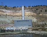
Glendo Powerplant |
Structure number |
PG-2 |
Wyoming State Engineer’s Office permit number |
P21145D |
Permitted conveyance (cubic feet per second) |
3,340.00 |
Priority date |
01-13-1953 |
Location – SEO district number |
3 |
Location – SEO district office |
Wheatland |
Location – Qtr/Qtr (if available)/Section/Township/Range |
SE1/4NW1/4 S24-T29N-R68W
|
Water source |
North Platte River |
Photograph courtesy of USBR
|
|
Casper Canal |
Structure number |
PG-3 |
Wyoming State Engineer’s Office permit number |
P18488D |
Permitted conveyance (cubic feet per second) |
337.95 + Supplemental Supply |
Priority date |
07-27-1934 |
Location – SEO district number |
11 |
Location – SEO district office |
Casper |
Location – Qtr/Qtr (if available)/Section/Township/Range |
SW1/4SE1/4 S23-T30N-R83W
|
Water source |
North Platte River |
Photograph courtesy of USBR
|
|
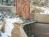
Douglas Canal (pump station) (Canon #4) |
Structure number |
PG-4 |
Wyoming State Engineer’s Office permit number |
P6101D |
Permitted conveyance (cubic feet per second) |
37.84 |
Priority date |
07-07-1904 |
Location – SEO district number |
14 |
Location – SEO district office |
Douglas |
Location – Qtr/Qtr (if available)/Section/Township/Range |
S28-T32N-R71W and others
|
Water source |
North Platte River |
Date of photograh |
2-23-2005 |
|
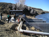
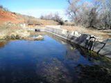
West Side Ditch |
Structure number |
PG-5 |
Wyoming State Engineer’s Office permit number |
Territorial, P1429E, P4055E, P16986D, P4531E, P4759E, P5403E, P6157E, P6111E, P6782R |
Permitted conveyance (cubic feet per second) |
38.16 + Reservoir Supply, Supplemental Supply, & Secondary Supply |
Priority dates |
06-1886, 04-07-1904, 09-21-1905, 11-17-1919, 12-14-1909, 12-17-1926, 01-22-1931, 04-02-1935, 02-04-1957, 04-14-1964, 04-14-1964
|
Location – SEO district number |
20 |
Location – SEO district office |
Douglas |
Location – Qtr/Qtr (if available)/Section/Township/Range |
S16-T32N-R73W
|
Water source |
LaPrele Creek |
Date of photograh |
2-23-2005 |
|
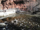
East Main Canal (Table Mountain or LaPrele Main, Powell & Ayres) |
Structure number |
PG-6 |
Wyoming State Engineer’s Office permit number |
Territorial, P41D, P5198D, P6529D, P1430E, P1670E, P1956E, P2968E, P4054E, P4139E, P4530E, P4589E
|
Permitted conveyance (cubic feet per second) |
136.08 + Secondary Supply |
Priority dates |
04-01-1884, Fall 1889, 06-25-1890, 05-02-1891, 03-30-1902, 02-20-1905, 09-21-1905, 03-18-1907, 03-25-1907, 05-11-1914, 11-17-1919, 07-26-1920, 12-17-1926, 07-09-1928 |
Location – SEO district number |
20 |
Location – SEO district office |
Douglas |
Location – Qtr/Qtr (if available)/Section/Township/Range |
S21-T32N-R73W
|
Water source |
LaPrele Creek |
Date of photograh |
2-23-2005 |
|
|
|