Wyoming State Water Plan
Wyoming State Water Plan
Wyoming Water Development Office
6920 Yellowtail Rd
Cheyenne, WY 82002
Phone: 307-777-7626

Wyoming Water Development Office
6920 Yellowtail Rd
Cheyenne, WY 82002
Phone: 307-777-7626


| SUBJECT: |
Appendix H Recreational Uses |
| PREPARED BY: | HKM Engineering Inc. |
| DATE: | March 2002 |
GENERAL
Attempts to put numerical values on water-based recreation in Wyoming have been hit-and-miss. For instance, the Wyoming Business Council has tracked information on recreation for some time, but doesn't distinguish between water-based recreation and other types. The U.S. Fish and Wildlife Service tracks water-based recreation in fishing and waterfowl hunting, but does it on a gross, national basis. And the U.S. Forest Service and Bureau of Land Management have little budget, time, or impetus to track such numbers.
The Northeast Wyoming River Basins has limited surface water recreation available in general. But it doesn't lack for demand. In the following text, discussions of the pressures on Keyhole Reservoir and attempts to create a minimum recreation pool there are indicators of its importance to recreation in the area. In 1988, Weston County commissioned a study to establish a recreational reservoir on Beaver Creek near Newcastle. The $2.8 million price tag (not including operational expenses) proved to be too steep for the county to support, but the Level I Study acknowledges the demand for such a facility (Bearlodge Ltd., Oct. 1989). And an economic study of the Keyhole Reservoir drawdown indicates that at least 82 percent of the in-state visitors (or approximately 59,000 visitors) came from Campbell and Weston counties (Wyoming Department of Commerce, Division of Parks and Cultural Resources, State Parks and Historic Sites, June 1993, p. 1). A large part of recreational demand is tied up in still-water recreation types like those found at Keyhole: boating, fishing and camping.
The numbers that are available are presented here, and with them (and perhaps more importantly) are the qualitative assessments of water-based recreation in the Northeast Wyoming River Basins. More in-depth looks at fishing, waterfowl hunting, boating, instream flows, and swimming and a detailed picture of the most significant reservoir that supports recreation in the basin follow. In the last few sections, some of the information is provided to illustrate what reservoir levels and stream flows maximize recreational use of the water in the basin.
Wyoming Business Council (WBC)
The WBC has only been using the current vendor to create the Economic Impacts of Tourism since 1995. Thus, the council distributes information based only on the most recent years.
The council's vendor conducts surveys in Sheridan and Casper for the regions 3 and 4 (Goshen, Platte, Niobrara, Converse, Natrona, and Fremont counties comprise region 3; Park, Hot Springs, Washakie, Big Horn, Sheridan, Johnson, Campbell, Crook, and Weston counties comprise region 4). The organization does not attempt to break the information down per county, per basin, or per activity. The data included in the following tables were generated from statewide data on the assumption that the percentage of people engaging in an activity in Converse County approximates that of people in Sheridan County (Janice Houston, WBC, March 2001).
The statewide breakout of activities enjoyed by visitors to Wyoming, provided below, also comes from the Wyoming Business Council:
| Activities of all Wyoming Visitors |
1995 | 1996 | 1997 | 1998 | 1999 |
| Visit Nat'l Forest | 28% | 30% | 24% | 27% | 19% |
| Hike | 25% | 20% | 19% | 24% | 14% |
| Camp | 18% | 19% | 12% | 12% | 10% |
| Fish | 16% | 13% | 10% | 9% | 10% |
| Hunting | 4% | 3% | 2% | 1% | 1% |
U.S. Fish and Wildlife Service (USFWS)
To clarify the picture somewhat, the USFWS has attempted to quantify the economic impact of wildlife-related tourism. The federal agency has compiled data on income generated by wildlife-watchers in each state based on the 1996 National Survey of Fishing, Hunting and Wildlife-Associated Recreation. It does not break out the numbers based on riparian-area wildlife or other wildlife closely tied with surface waters, but because much of the wildlife in Wyoming aggregates near streams or reservoirs, this information cannot be wholly dismissed.
According to the report, Wyoming enjoyed $217.5 million in expenditures or sales related to wildlife watching, resulting in $316.7 million in total industrial output. This activity created or maintained 6,193 jobs, which produced $82.8 million in income, $8.7 million in state sales tax revenue, and $13.1 million in federal income taxes. The generated employment income as a percentage of total state wage and salary disbursements were 1.53 percent, second only to the State of Alaska's 3.02 percent (1996 National and State Economic Impacts of Wildlife Watching, USFWS, 96-1, pp. 8-9).
FISHING
Fishing represents the biggest recreation-related water use in the Northeast Wyoming River Basins. And as with boating, fishing is a non-consumptive use dependent in most cases on water devoted to other uses like irrigation. The exception can be found in the instream flow segment filed in the basin by the Wyoming Game and Fish Department (WGFD) (see Instream Flow section).
The economic impact of sport and commercial fishing, broken out here on a statewide basis, is obvious:
Five-year trends in Wyoming's sport fisheries program
| Fiscal Year |
Recreation Days |
Fish/Day | Licenses Sold |
License Revenue ($) |
Program Costs ($) |
Angler Expend. ($) |
| 1995 | 4,086,400 | 2.5 | 331,229 | 2,951,133 | 10,530,957 | 226,672,608 |
| 1996 | 4,035,300 | 2.5 | 428,186 | 3,431,432 | 10,546,977 | 228,317,274 |
| 1997 | 4,039,000 | 2.5 | 453,101 | 4,040,247 | 11,310,029 | 233,696,540 |
| 1998 | 4,553,489 | 2.5 | 475,096 | 4,038,267 | 11,420,299 | 267,699,618 |
| 1999 | 4,564,031 | 2.5 | 497,064 | 4,242,445 | 13,494,171 | 632,829,438 |
| Recreation days revised to include unlicensed anglers, pioneers, and 6-13 year-olds. License revenue does not include sale of nonresident special and nonresident youth elk and fishing license income. Angler expenditure information is based on 1998 survey, "Wyoming 1998 Fishing Trip Expenditures" (Responsive Management National Office). The new information accounted for the nearly $365,000,000 increase from the preceding year (1998). All other agency revenue includes allocated application fees, conservation stamp revenue, federal/other grants and interest earned on Game & Fish cas balances. Total Program Revenue based on fiscal year, all other figures on calendar year basis. ( WGFD Annual Report 2000, p. 80) | ||||||
Though the discrepancy between the license revenue and the program costs indicates that the program is subsidized, the return in annual angler expenditures in the state more than outweighs this apparent subsidization and underscores the importance of angler recreation to state and private coffers.
These numbers aren't broken down to encompass the effects of angling in the Northeastern Wyoming River Basin, and the WGFD doesn't provide an accurate means of doing so. The information is provided as context only.
The State of Wyoming classifies trout streams under five designations (WGFD, rev. 1991):
The Northeast Wyoming River Basins contains two sections of Class 1 stream and one section of Class 2 stream, but they all lie in Sand Creek on the Redwater Creek drainage. This highlights the basin's flashy runoff, relatively flat drainages, and predominance of erodable soils, none of which are conducive to trout fisheries.
The WGFD maintains the most complete database on fisheries and anglers available. In response to a request for fishing activity in the basin, the agency provided its most recent database. Queries to that database yielded the following information about the fishing supported in the basin (Bob McDowell, WGFD, personal communication and Sheridan Lake Data database, 16 April 2001):
Recent Fishing Activity, Northeast River BasinThe definition of alpine versus lowland in this list divides at 7,500 feet in elevation . something not found in the Northeast Wyoming River Basins. Not surprisingly, the accessibility and species richness available in lowland reservoirs like Keyhole Reservoir draws the most fishing pressure.
Angler Days by Standing Water Type
Type Angler-Days Unsuitable 59.6 Natural Alpine Lake None Alpine Reservoir None Natural Lowland Lake None Lowland Reservoir 45,704.2 Trout Farm Pond 1,013.9 Mixed Farm Pond 1,855.2 Non-Trout Farm Pond 120.0 Total 48,752.9
Gillette Fishing Lake, a warm-water fishery, has also generated fishing pressure in the past, but is currently listed in the Department of Environmental Quality's 303(d) list, a precursor to receiving a Total Maximum Daily Load assignment to reduce the pollutants of phosphates and siltation. Data were not available for determining the impact of this listing on fishing activity from the reservoir owner, the City of Gillette.
The WGFD breaks out stream angling in a separate analysis for the basin (Bob McDowell, WGFD, personal communication and Sheridan Stream Data database, 18 April 2001). The 35 streams tracked for angling support 13,442 angler days.
The WGFD has also published A Strategic Plan for the Comprehensive Management of Wildlife in Wyoming, 1984-1989. Though the data provided in this publication lend themselves well to the analyses demanded in this project, WGFD personnel asked that the individual Basin Management Plans for each of the water bodies in the basin be used here for their more current information (Chris Burkett, WGFD, personal communication, 19 April 2001). The following table of usage data is taken from the management plans obtained from Bob McDowell. [Note: The data are taken from the database over a period of time; the basin plans are undated and can be expected to contain older information.]
Angling pressure per drainage from WG&F management plansThough these numbers give some idea of the impact of the surface water resources on fishing in the Northeast Wyoming River Basins, they do not give any impression of the stream flows and lake levels that would maximize recreational opportunities. Various angling experts and biologists asked for this type of information reflected that the information doesn't exist on a quantitative level, for the most part.Belle Fourche River Drainage:
Note: *Includes Keyhole Reservoir
Streams Total Angling Pressure
(angler days/yr)12,231 Lakes/Reservoirs 21,166* Keyhole Reservoir 5,467**
**Dated pre-1997Little Missouri River Drainage:
Streams Total Angling Pressure
(angler days/yr)90 Lakes/Reservoirs 2,377 Cheyenne River Drainage:
Streams Total Angling Pressure
(angler days/yr)1,062 Lakes/Reservoirs 13,732 Niobrara River Drainage:
Streams Total Angling Pressure
(angler days/yr)0 Lakes/Reservoirs 1,034
Two attempts to provide a quantitative analysis of what small reservoirs maximize chances of good fisheries (and thus, good recreational fishing) were authored by University of Wyoming professor Wayne Hubert and Paula Guenther. The first study indicates that lack of inflowing water, high elevation, extensive ice and snow, small surface area, and abundant aquatic macrophytes contribute to low dissolved oxygen concentrations during the winter that would in turn trigger fish mortality (Guenther and Hubert, Great Basin Naturalist, p. 284). The follow-up study created a winterkill risk rating system for fisheries managers to use as a decision-making tool in quandaries over stocking (Guenther and Hubert, Environmental Management, p. 647). Taken together, these analytical tools and observations are limited to small, cold-water reservoirs (<100 ha and <20°C), but provide the tools to assess what small reservoirs could support fisheries, and their likelihood of maximizing recreational use. But no application of these tools could be found.
In part, the reason for this lack lies in the extreme variability in the geographic and geological areas of the Northeast Wyoming River Basins. Respondents to these questions noted that it would be necessary to determine which stream, which segment on that stream should be analyzed before an optimum level for recreational use could be determined. They had a similar response to standing water optimization.
WATERFOWL HUNTING
The harvest of migratory waterfowl is a recreational pursuit affected by the presence or absence of water. Wetlands and open water are needed for breeding, nesting, rearing, feeding and isolation from land-based predators. In the Northeastern Wyoming River Basin, waterfowl hunting is pursued where sufficient local or migratory populations are available. The Northeastern Wyoming River Basin represents the western extreme of the central flyway (Barry Floyd, Personal Communication, 10 April 2001).
Ducks Unlimited is interested in the Northeastern Wyoming River Basin for its status as a secondary, pothole terrain for waterfowl. The organization considers the area a priority for long-range planning. In addition to its natural amenities for ducks, the Northeast Wyoming River Basins doesn't have the pesticides or predator pressures that are found in the traditionally more productive plains regions to the east. As a result, the area supports a higher ratio of young per nest than can be found to the east (ibid).
Waterfowl hunters spend a significant amount of money in the hunt every year, according to the U.S. Fish and Wildlife Service (USFWS), but in the Northeast Wyoming River Basins, many hunters hunt ducks and geese only when other hunts are out of season. By one estimation, only 50 percent of the approximately 12,000 duck stamp purchasers in the state are committed to hunting ducks (ibid), making the economic impacts of waterfowl hunting difficult to assess.
That being said, the 1996 USFWS national survey notes that migratory bird hunters make the following average expenditures:
Trip and Equipment Expenditures for Migratory Bird Hunting: 1996
| Expenditure Item | Ave. Expenditure ($) |
| Trip-Related | $216 |
| Equipment | $312 |
| Auxiliary Equipment | $183 |
| Specialized Equipment | $2,195 |
| TOTAL | $2,906 |
The USFWS includes food and lodging, transportation, and various fees in its trip-related expense. Equipment includes decoys, ammunition, dogs, firearms, and associated costs. Auxiliary equipment includes camping equipment, binoculars, specialized personal gear, and taxidermy. Specialized equipment includes boats, campers, cabins, trail bikes, etc.
Ducks Unlimited regional biologist Jon Roaldson notes that hunters won't make these expenditures unless the waterfowl are present. He says the water needs of ducks (and by extension, hunters and bird-watchers) are straightforward. In general, the best water conditions can be found in littoral zones, where light penetrates to the bottom of the channel or still water. This allows a number of invertebrates to survive that in turn provide waterfowl with the protein they need in breeding and brooding seasons. For everything except diving ducks, the optimal depth is approximately three feet, with anything greater than six feet being excessive (Roaldson, D.U., April 2001).
The Northeast Wyoming River Basins has been pockmarked with glacial or wind-formed palustrine basins that migratory waterfowl consider attractive, according to Roaldson. The shallow, warmer waters of these basins provide good breeding and courtship habitat, but must have seasonal wetlands of heavy brush to support brooding activities.
Many of the dams created to hold coalbed methane discharge water create the shallow basins Roaldson talks about, but they need time to develop proper benthic life or their water quality is not conducive to that life, limiting their productivity for waterfowl.
The USFWS sets nationwide waterfowl hunting seasons and bag limits. Since 1995, the agency has set seasons to manage duck harvest rates under the concept of "Adaptive Harvest Management" or AHM (USFWS, 1999). This concept is described by the USFWS as follows:
The annual process of setting duck-hunting regulations in the United States is based on a system of resource monitoring, data analysis, and rule making. Each year, monitoring activities such as aerial surveys and hunter questionnaires provide information on harvest levels, population size, and habitat conditions. Data collected from this monitoring program are analyzed each year, and proposals for duck- hunting regulations are developed by Flyway Councils, States, and the U.S. Fish and Wildlife Service (USFWS). After extensive public review, the USFWS announces a regulatory framework within which States can set their hunting seasons.
Essentially, AHM allows annual duck population surveys and hunter input to re-evaluate seasons and harvest on an annual basis. States are then allowed to impose more stringent seasons and bag limits than the USFWS sets, if they wish. As populations increase above the desired population goal, hunting seasons and bag limits are made more liberal, while population decreases have the opposite effect. The primary population studied by the USFWS is the mid-continent mallard stock, with efforts underway to include other stocks and species. In recent years, duck populations have been strong and liberal seasons and bag limits have benefited sportsmen.
Harvest objectives are not currently used (post-1993), because harvest is taken into account in the setting of season length and bag limits by the USFWS using AHM. In effect, the desired harvest is a prospective number using past hunter success, population effects, and regulations in concert with current-year populations. With current duck populations and hunting pressure, it appears there is a sufficient resource to provide a quality duck hunting experience now and in the near future, with the existing water resources of the basin.
Similarly, goose hunting seasons and bag limits are set under guidelines from the USFWS, although states have more flexibility in setting bag and possession limits. And like duck populations, goose populations are strong and increasing. With approval from USFWS, states can set special seasons to allow depredation harvest from growing local flocks. According to historic estimates, the Rocky Mountain Population (RMP) of Canada geese has grown approximately four-fold since 1972 (Wilkins and Cooch, 1999). Since 1989, populations have increased at a rate of eight percent per year.
BOATING
Many of the Northeast Wyoming River Basins' lakes support boating activities, including whitewater, scenic, fishing, or water skiing. Boaters tend to use Gillette and Keyhole reservoirs. Boating is a non- consumptive use because it depends on waters being maintained for other purposes.
Because permits are not required for boating anywhere in the Northeast Wyoming River Basins, usage numbers that could be used to indicate capacity limits and pressures are not available from management agencies. The Bureau of Reclamation's default figure of one boat per 10 surface acres of water is used to estimate capacities elsewhere, but until use numbers are generated, that guideline cannot be used.
Game and Fish and reservoir operations personnel note that the optimum reservoir level for boaters is at maximum reservoir level (Bob McDowell, personal communication, 16 April 2001). Otherwise, boaters must pay close attention to emerging hazards, particularly if towing water-skiers.
At present, no central agency controls float trips on the larger streams, though locals float the Belle Fourche on occasion. No numbers are available on this use of streams within the basin.
MINIMUM (CONSERVATION) POOLS AND MINIMUM FLOW RELEASES
Minimum conservation pools and minimum flow releases are not available or are nonexistent in the standing water of the Northeast Wyoming River Basins. Low water levels in Keyhole Reservoir between 1989 and 1991 sparked a discussion between Wyoming, South Dakota, and the Crook County Irrigation District over establishing a conservation pool.
A series of dry years culminated in a 17-foot decrease in the water level in Keyhole from average levels in 1981. During the mid-1980s the water level rebounded slightly but decreased again during 1989 . 1991. At that time, South Dakota irrigators who usually depended on the Belle Fourche Reservoir relied on Keyhole, effecting an extreme drawdown. Most of the park's boat ramps became unstable and recreation once close to shoreline became distant from the edge. The recreation pool was proposed in 1990, and the Wyoming legislature appropriated funds in 1994 to establish the pool. The Crook County Irrigation District and the State of Wyoming could not reach an agreement on the issue. Funding for the project expired in June, 1996, and now the Bureau of Reclamation touts the recreational pool creation in Keyhole, but with little support at present from Wyoming (USBR, "Belle Fourche/Keyhole Project Review Report," 1998, p. 11).
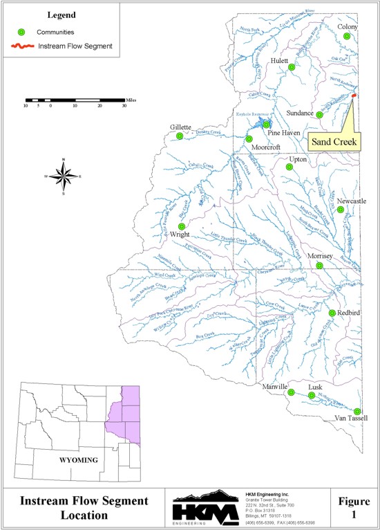
INSTREAM FLOWS WITHIN THE NORTHEAST WYOMING RIVER BASINS
Instream flow by definition is an arrangement tailored to keep water in streams. It can be accomplished through current direct-flow rights (i.e., changing the point of use of a water right), building storage for the purpose, or changing the timing on reservoir releases.
Existing instream flow rights filed in the Northeast Wyoming River Basins include (Figure 1):
| Drainage | Tributary | Location |
| Sand Creek |
Redwater Creek |
From the south boundary of the SW quarter of the NE quarter, section 7, township 52, range 60 to the north boundary of the SE quarter of the SW quarter, section 5, township 52, range 60 (2.5 miles long). |
SWIMMING
Swimming is generally undertaken incidentally to other activities. While some lakes and reservoirs are suitable for swimming and water-skiing (i.e. Keyhole Reservoir), many have bottom strata that are not conducive to swimming.
SIGNIFICANT LAKES AND RESERVOIRS
Keyhole Reservoir
General
The biggest still-water recreation attraction in the Northeast Wyoming River Basins, Keyhole Reservoir supports skiing, fishing, swimming, boating, and camping and has been doing so essentially since its construction in late 1952. Part of the Pick-Sloan Missouri Basin Program, the "Keyhole Unit," named after the Keyhole Ranch it was constructed on, is run by the U.S. Bureau of Reclamation. Though the Wyoming Department of State Parks and Cultural Resources (WDSPCR) manages Keyhole State Park, at the eastern end of the reservoir, under a memorandum of understanding and cooperative agreement with the Bureau of Reclamation, experience has shown that the water levels controlled by the Bureau of Reclamation have a large impact on recreation.
The State Park area consists of a marina-concessionaire, motel, campgrounds, boating ramps, day-use areas, picnic areas, playground, swimming beach, restroom facilities, and trailer sanitary station. Under a dual management agreement on the western portion of the reservoir lands, the Bureau of Reclamation manages the grazing leases and leaves WDSPCR with the general recreation activities not associated with the park. The Keyhole and Sundance Boat Clubs, private exclusive use areas near the Pronghorn Campground, offer cabins and mobile home trailers. The club leases the space from WDSPCR (Bureau of Reclamation, pp. 4-6).
Until 2000, the park's season ran from May 1 . Sept. 31, but that year, park management began collecting fees year 'round in reaction to the increase in the previous six years of off-season use. Ninety-five percent of visitors come from Wyoming, South Dakota, North Dakota, Nebraska, and Colorado. The remaining five percent come from the rest of the United States, Canada, and other foreign nations. Visitor counts from the park indicate a growing number of visitors that generally coincides with a shorter stay at the park.
Keyhole State Park Visitor CountsThis analysis is somewhat hampered by what is not shown here: water levels in Keyhole. As the Bureau of Reclamation puts it, "A series of dry years ended the relative stability of Keyhole's water level," (Bureau of Reclamation, "Belle Fourche/Keyhole Project Review Report," p. 5). That meant that in 1981, the water level dropped 17 feet and was slow to rise again. The Wyoming Game and Fish Department (WGFD) notes in its "Basin Management Plan for Keyhole Reservoir" that the water level continued to drop to 9.8 percent of capacity in 1992, then climbed 34 feet to its 1996 level (WGFD, p. 3). According to "The Economic Impact of Minimum Pool Level Maintenance within Keyhole Reservoir" (WDSPCR, 1993), the pool levels fluctuated later in the 80s and 90s. The following table, taken from that report, is provided there as an illustration of the interconnection between water level and visitation at the park:
Year Visitors Visitor Days
(based on a
12-hour stay)1988 114,640 Not available 1989 101,452 Not available 1990 110,199 Not available 1991 107,587 Not available 1992 85,084 357,650 1993 87,566 368,084 1994 122,813 231,728 1995 140,766 265,601 1996 155,334 293,096 1997 158,381 298,897 1998 165,268 238,123 1999 172,978 249,233 2000 201,124 289,789
Keyhole Pool Level and Visitation for 1987 through 1992 (WDSPCR, p. 1)By this analysis, a 25,000 acre-foot pool is responsible for 209,701.8 visitor days (ibid, p. 1). The economic impact of these visitor days is significant, as the following table shows:
Year Visitation Pool Level (acre feet) 1987 115,376 84,934.6 1988 114,640 65,028.6 1989 101,452 49,902.6 1990 110,199 41,359.0 1991 107,587 39,875.4 1992 85,084 28,269.2 Average 109,850.8 56,220.0
Estimated Sales and Use Tax Revenue Generated by theThis decrease in recreational use makes sense, given that the park's boat ramps become unstable and the shoreline becomes distant when water levels drop in the reservoir. In addition, the Bureau of Reclamation notes that the decrease in water level affects the fisheries in the reservoir. Wyoming interests proposed a recreation pool in 1990 to everyone involved with the reservoir. The Crook County Irrigation District in Wyoming did not choose to adopt the proposal and no further recreation proposals have been offered since then. This too, makes sense, given that the water levels in the reservoir have been quite high in the years since.
25,000 Acre-Foot Pool at Keyhole Reservoir (WDSPCR, p. 2)
1993 1994 Visitor Days 209,701.1 290,701.1 Non-Resident 72,346.9 72,346.9 Resident 137,854.2 187,854.2 Expenditures per visitor day Non-Resident $37.66 $38.81 Resident $32.14 $33.10 Total Expenditures Non-Resident $2,725,770.00 $2,807,543.10 Resident $4,413,887.67 $4,546,304.30 Total $7,139,657.67 $7,353,847.40 Sales/Use Taxes $214,189.73 $220,615.42 County S/U Taxes $58,791.19 $60,301.55
Fishing
The WGFD maintains a basin management plan for Keyhole Reservoir that provides the long list of species anglers can find and their relative abundance.
The WGFD manages Keyhole for walleye production but stocks a number of species during any five-year period. Much of the stocking is done with "forage fish," which are stocked to provide young-of-the-year fingerlings for other fish to feed on.
Primary Management
SpeciesNative Species Exotic Species Walleye
Northern Pike
Small-Mouth Bass
Channel CatfishBlack Bullhead
Flathead Catfish
Northern Redhorse
River Carp Sucker
Sand Shiner
White SuckerChannel Catfish
Flathead Minnow
Plains Minnow
Red Shiner
Spot-Tail Shiner
Black Croppie
Emerald Shiner
Green Sunfish
Large-Mouth Bass
Small-Mouth Bass
White Croppie
Carp
Freshwater Drum
Gizzard Shad
Northern Pike
Walleye
Yellow Perch
A 1985 creel survey revealed that fishermen exerted a pressure of 5,467 angler-days (1.65 per acre of surface water) and 23,727 angling hours (7.2 per acre of surface water). Note that this survey was conducted when the water level was quite low. At full pool, the reservoir has approximately 9,411 surface acres; the area during the survey was estimated to be 3,300 surface acres.
REFERENCES
Annear, Tom, Wyoming Game and Fish instream flow specialist, personal communication, 7 March 2001.
Bradshaw, Bill, Wyoming Game and Fish Department, "Basin Management Plan for Fisheries: Cheyenne River Drainage (FXSN8CH)," Nov. 1996.
Floyd, Barry, Ducks Unlimited Wyoming state director, Personal Communication, April 10, 2001.
Guenther, Paula M. and Hubert, Wayne A., "Factors Influencing Dissolved Oxygen Concentrations During Winter in Small Wyoming Reservoirs," Great Basin Naturalist. Vol. 51, no. 3, Sept. 1991.
Guenther, Paula M. and Hubert, Wayne A., "Method for Determining Minimum Pool Requirements to Maintain and Enhance Salmonid Fisheries in Small Wyoming Reservoirs," Environmental Management. Vol. 17, no. 5.
Houston, Janice, Wyoming Business Council data specialist, e-mail communication, 8 March 2001 . 9 April 2001.
McDowell, Bob, Wyoming Game and Fish Department, "Belle Fourche River Basin Plan: Plan Number FXSN8BF," Dec. 1996.
McDowell, Bob, Wyoming Game and Fish Department, "Basin Management Plan for Fisheries: Little Missouri River Drainage (FXSN8LM)," Dec. 1996.
McDowell, Bob, Wyoming Game and Fish Department regional fisheries supervisor, personal communication, 16 April 2001.
Roaldson, Jon, Ducks Unlimited regional biologist, Personal Communication, April 10, 2001.
Siefert, Ron, Wyoming Department of State Parks and Historic Sites, Keyhole State Park director, personal communication, 9 March 2001.
Stewart, Bud, Wyoming Game and Fish Department, "Basin Management Plan for Fisheries: Keyhole Reservoir (FXSN8KH)," Nov. 1996.
U.S. Bureau of Reclamation, "Belle Fourche/Keyhole Project Review Report," Rapid City, South Dakota, 1998.
U.S. Department of the Interior, Fish and Wildlife Service, 1999, Adaptive Harvest Management, 1999 Duck Hunting Season.
U.S. Department of the Interior, Fish and Wildlife Service and U.S. Department of Commerce, Bureau of the Census. 1996 National and State Economic Impacts of Wildlife Watching, Washington, D.C., 1996.
U.S. Department of the Interior, Fish and Wildlife Service and U.S. Department of Commerce, Bureau of the Census. 1996 National Survey of Fishing, Hunting, and Wildlife-Associated Recreation, FHW/96 NAT, Washington, D.C., 1996.
Welker, Mike, Wyoming Game and Fish Department, "Niobrara River Basin Management Plan FXSN8NR," Dec. 1991.
Wilkins, K.A. and E.G. Cooch, 1999, "Waterfowl Population Status, 1999," U.S. Fish and Wildlife Service, Department of the Interior, Washington D.C., 33 pp. and appendices.
Wyoming Department of Commerce, Division of Parks and Cultural Resources, State Parks and Historic Sites, " The Economic Impact of Minimum Pool Level Maintenance within Keyhole Reservoir," Cheyenne, Wyoming, 15 June 1993.
Wyoming Game and Fish Department, Sheridan Lake Data, MS Excel spreadsheet, 16 April 2001.
Wyoming Game and Fish Department, Sheridan Stream Data, MS Excel spreadsheet, 18 April 2001.
Wyoming Game and Fish Department, Wyoming Game and Fish Department Annual Report 2000, Cheyenne, Wyoming, Dec. 2000.
Wyoming Game and Fish Department, 1991 (rev), "Wyoming Trout Stream Classification Map."