Wyoming State Water Plan
Wyoming State Water Plan
Wyoming Water Development Office
6920 Yellowtail Rd
Cheyenne, WY 82002
Phone: 307-777-7626

Wyoming Water Development Office
6920 Yellowtail Rd
Cheyenne, WY 82002
Phone: 307-777-7626


| SUBJECT: |
Appendix O Irrigation Water Needs and Demand Projections |
| PREPARED BY: | Watts and Associates, Inc. |
| DATE: | February 2002 |
INTRODUCTION
This memorandum presents projections of water requirements in Northeast Wyoming River Basins for the period from 2000 through 2030. Following guidelines established by the Wyoming Water Development Commission (WWDC), projections were developed for three planning scenarios:
BACKGROUND
Irrigated agriculture is the largest user of water in the Northeast Wyoming River Basins. The irrigated lands analysis conducted by HKM Engineering (2002a) indicates that there are about 86,900 acres of irrigated land in the planning area. Of this total, about 9,500 are idle, primarily due to water delivery system problems, and another 1,600 acres have been converted or are in the process of conversion to residential use. Of the remaining 75,800 acres that are actively irrigated, 64,300 are served primarily by surface water and the remainder by groundwater. Spreader dikes or intermittent diversions are used to irrigate about 30,300 of the 64,300 acres served by surface water. Total surface water depletions in the Northeast Wyoming River Basins are estimated to be about 69,500 acre-feet in a normal year (HKM, 2002b), or about 1.08 acre-feet per acre for actively irrigated lands with surface water diversions.
The majority of irrigated land is devoted to the production of forage crops such as alfalfa, grass hay, and irrigated pasture. According to the Wyoming Agricultural Statistics Service (WASS, 2000), alfalfa and grass hay have been harvested on an annual average of 27,400 acres of land in the planning area over the past 20 years. Other irrigated crops grown in the planning area include small grains (about 3,000 acres annually), and corn (about 2,700 acres annually). The WASS does not keep records of irrigated pasture acreage or production, but the majority of the 42,700 actively irrigated acres not accounted for above are probably devoted to irrigated pasture.
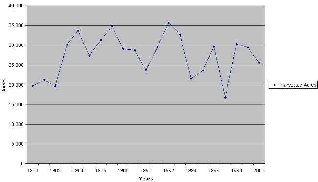
Figure 1 shows estimates of harvested forage acreage in the planning area for the period from 1980 through 2000, as developed by the WASS.1 That figure shows that the number of acres of forage crops harvested each year varied from a low of about 17,000 acres to a high of about 36,000 acres. There appears to be no trend of increasing or decreasing production over time, meaning that the annual variations are likely attributable to variables such as weather, irrigation water availability, and cattle prices.
Figure 1
Northeast Wyoming River Basins Harvested Forage Acreage
1980-2000
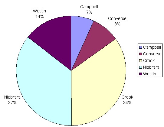
The distribution of harvested forage acreage by county is depicted in Figure 2. That figure shows that Niobrara County is the largest forage producer in the planning area, producing an average of 37 percent of all forage harvested over the period from 1980 through 2000. Crook County is the second largest producer with 34 percent of the total, followed by Weston County with 14 percent, and Converse and Campbell counties with eight percent and seven percent, respectively.
Figure 2
Distribution of Northeast Wyoming River Basins Harvested Forage Acreage by County
(1980-2000 Average)
The only significant irrigation water storage facility in the Northeast Wyoming River Basins is Keyhole Reservoir, a multipurpose facility operated by the Bureau of Reclamation. It can store up to 185,800 acre-feet of irrigation water, of which irrigators in South Dakota control 90 percent. About 18,000 acre- feet of Keyhole's storage is owned by the Crook County Irrigation District, which uses the water to supplement direct flow rights along the lower Belle Fourche River in Wyoming. The only other irrigation reservoirs in the planning area are a few small privately owned facilities. A complete description of storage facilities in the planning area is presented in a separate technical memorandum (HKM, 2002c).
The lack of storage facilities in most parts of the Northeast Wyoming River Basins is partially offset by the availability of groundwater in some parts of the planning area. The fact that almost 18,000 acres of land are irrigated primarily by groundwater is evidence of its importance in agricultural production.
TRENDS IN LIVESTOCK PRODUCTION
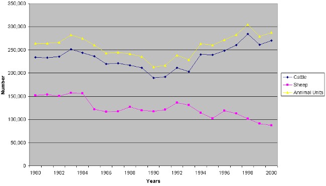
Trends in cattle and sheep inventories in the Northeast Wyoming River Basins are depicted in Figure 3. These estimates were developed from WASS county estimates adjusted to planning area totals based upon the amount of land area in each county that is in the Northeast Wyoming River Basins. Figure 3 shows that the cattle inventory in the planning area has been increasing in recent years while the sheep inventory has been decreasing. Cattle numbers have increased from a low of about 190,000 head in 1990 to about 270,000 head in the year 2000. During the period from 1992 through 2000, sheep numbers decreased from about 140,000 to 90,000. These trends reflect the fact that sheep production has become relatively unprofitable in recent years and many ranchers are shifting from sheep to cattle production as a result.
Figure 3 also shows the trend in total animal units in the planning area based upon the conversion factor that five sheep are roughly equivalent to one cow in terms of forage requirements (Sedivec, 1996). The figure shows that the total number of animal units in the planning area has increased somewhat over the past 20 years, from about 260,000 units in 1980 to about 290,000 units in the year 2000. The total number of animal units has varied considerably over that time period, however, from a low of 210,000 in 1990 to a high of just over 300,000 units in 1998. These variations reflect changes in livestock prices, water availability for irrigation, and other factors that affect the profitability of livestock production over time. Figure 3 seems to indicate that the productive capacity of the livestock industry in the planning area is roughly 300,000 animal units.
Figure 3
Northeast Wyoming River Basins Cattle and Sheep Inventory
1980-2000
The distribution of cattle and sheep by county is depicted in Figures 4 and 5. These figures reflect average annual livestock inventories over the period from 1980 through 2000. Figure 4 shows that Crook County has been the largest cattle producer, with 29 percent of basin-wide cattle inventories over the past 20 years. Niobrara and Weston Counties have averaged 21 and 20 percent of basin-wide production respectively, followed by Converse County with 16 percent and Campbell County with 14 percent.
Average sheep inventories by county are depicted in Figure 5. That figure shows that Converse and Crook Counties have been the largest sheep producers in the planning area over the past 20 years, with 35 and 24 percent of basin-wide production respectively. Campbell County accounted for 19 percent of production during that period, while Niobrara and Weston Counties accounted for 13 percent and nine percent, respectively.
Figure 4
Distribution of Northeast Wyoming River Basins Cattle
by County
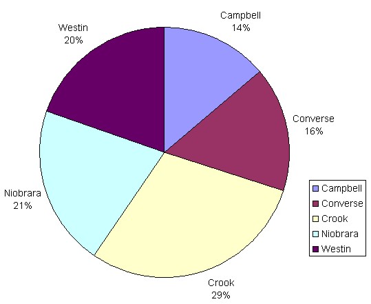
Figure 5
Distribution of Northeast Wyoming River Basins Sheep
by County

Several factors limit the capacity of the livestock industry in the planning area. One limiting factor with respect to herd size is the amount of summer range available on federal lands, which constitute a large proportion of rangeland in the Northeast Wyoming River Basins. Both the U.S. Forest Service (USFS) and the Bureau of Land Management (BLM) have become more conservative in recent years with respect to the management of grazing allotments in response to environmental concerns. Thus, there appears to be little opportunity for producers to increase future production by expanding grazing on federal lands.
Another factor limiting the capacity of livestock production is the amount of forage that can be produced on private land holdings. The potential for increasing production on private lands is a function of irrigation water availability and the cost of developing that water. Developing new sources of irrigation water is a capital-intensive effort that has not been financially feasible for most producers over the past two decades. Thus, the productive capacity of the planning area's livestock industry has remained relatively constant over that period.
FUTURE WATER NEEDS AND DEMANDS
In discussing the future of irrigation in the Northeast Wyoming River Basins, it is necessary to distinguish between needs and demands for irrigation water. A need for additional irrigation water is an identifiable current or future use that would enhance the economic well being of the irrigator and/or the economy of the planning area as a whole. Demands are distinguished from needs by the fact that they are measured in relationship to price. To give a simple example, an irrigator may need additional irrigation water in a dry year to grow enough hay to provide winter feed for his cattle. If additional water costs $500 per acre- foot, however, the irrigator's demand for additional water would probably be zero because it would be more cost-effective to either buy additional forage from other producers or reduce the size of his herd.
In analyzing municipal and industrial water uses, needs and demands are often viewed interchangeably. The cost of water is usually a relatively minor part of the costs involved in developing water-intensive manufacturing facilities such as electric power plants and soda ash production facilities. As a result, it can be assumed that manufacturers will demand the water that they need to expand production over a reasonable range of prices. Similarly, municipal needs are usually assumed to be essential and thus will be translated into demands over a reasonable price range. That convention was used for projecting municipal and industrial demands in this planning study.
Irrigated agriculture, however, is an industry in which producers are very sensitive to the price of water, and their demands for water can change dramatically as a function of price.2 For that reason, this section of the memorandum discusses both irrigation water needs in the planning area and the circumstances under which those needs may be translated into future demands.
The hydrologic modeling effort undertaken for this planning study (HKM, 2002d), as well as conversations with irrigators and water professionals, indicate that there are many areas of the planning area that could benefit from additional irrigation water, especially in dry years. Areas of particular need include virtually all of the tributaries of the Beaver Creek and the Cheyenne and Belle Fourche Rivers. Additional irrigation water in these areas would stabilize forage production and allow ranchers to operate more profitably. Additional storage would also allow some operators to adjust more readily to potential future changes in the management of federal grazing allotments. Additional irrigation water could also allow producers to expand their cattle herds on private holdings or grow additional hay for sale outside of the planning area.
There are, however, several practical problems associated with developing new storage in the Northeast Wyoming River Basins. One such problem is a lack of potential sites with available water and cost effective dam building potential. The short list of potential irrigation storage projects developed for this study includes only a few small reservoir sites on tributaries of the Belle Fourche River below Keyhole Reservoir. Another practical problem with developing new storage in the Belle Fourche River Basin is the Belle Fourche River Compact, which prohibits the development of reservoirs of over 1,000 acre-feet of storage for irrigation in Wyoming.
A third problem associated with fulfilling the need for additional irrigation water in the Northeast Wyoming River Basins is that the returns to forage production in recent decades have not been sufficient to offset the costs of new water storage projects. Studies of returns to irrigation water in the Little Snake Drainage and in other parts of Wyoming indicate that one acre-foot of irrigation water used for forage production in relatively high altitude areas of the state can be expected to generate a $15 to $25 increase in net farm income (Western Research Corporation, 1989). The cost of developing new storage can be significantly higher than that figure even under very favorable circumstances. For example, the recently completed Greybull Dam and Reservoir in the Big Horn River Basin of Wyoming is considered a very cost-effective project from a cost per acre-foot of yield perspective. The project's total cost was approximately $25 million for 25,000 acre-feet of storage, or about $1,000 per acre-foot of storage (Tyrrell, 2000). On an annual basis, the project's cost is equivalent to $63.44 for each acre-foot of reservoir storage, excluding O&M charges.3
Current WWDC guidelines for new water project developments in Wyoming allow for up to a 50 percent state grant for project construction. If new irrigation water projects were developed in the planning area with WWDC assistance, the total cost of water would probably be at least $63.44 per acre-foot annually. Under current WWDC guidelines, irrigators would be responsible for annual payments of at least $31.72 per acre-foot of water plus O&M charges. Irrigators in the Big Horn River Basin can repay costs of this magnitude because they predominantly grow higher valued cash crops such as dry beans and sugar beets. However, these costs exceed the magnitude of returns that most producers in the planning area would realize from additional forage production under current market conditions.
One potential low cost source of supplemental irrigation water is CBM production water. Projections made for this planning study indicate that water production associated with CBM development in the planning area may exceed 50,000 acre-feet annually during this decade (Watts, 2002). There are several practical problems with using CBM water for irrigation, however, one of which is the fact that high levels of production are not expected to last more than eight to 10 years. Given this relatively short duration, it is doubtful that many irrigators would be willing to make the significant changes in their operations that would be required to put this water to beneficial use. Using CBM water for irrigation is also complicated by questions of water quality and the proximity of water production to areas of need. Unless these issues are resolved, there appears to be no significant long-term potential for enhancing agricultural production in the planning area through the use of CBM production water for irrigation.
The lack of potential storage sites, compact restrictions, and other considerations discussed above make it unlikely that significant amounts of demand for additional irrigation water will develop in the planning area over the next 30 years. That fact is discussed further in the irrigation water demand scenarios discussed below.
Low Growth Scenario
The low growth scenario is based upon the assumptions that irrigation in the Northeast Wyoming River Basins will continue to be dominated by forage production for winter livestock feed and that cattle and forage prices will not make sustained increases over the next 30 years relative to reservoir construction costs. This scenario also projects no increase in state funding available for new project construction and no change in WWDC criteria for financial assistance to project sponsors. As a result, irrigators will probably be unwilling to make long-term financial commitments to develop new storage following WWDC funding guidelines. Numerically, total consumptive water use for irrigation in the planning area is expected to remain relatively constant at 69,500 acre-feet in a normal year.
Moderate Growth Scenario
The moderate growth scenario is based upon the reasonably foreseeable possibility that cattle prices will increase significantly over the next 10 years as forecast by the USDA in response to increased demand for high quality beef in Pacific Rim markets (USDA, 2000). An increase in cattle prices, however, is unlikely to provide enough financial incentive for ranchers in water-short areas of the Northeast Wyoming River Basins to develop storage facilities given compact restrictions in the Belle Fourche River Basin and the lack of suitable sites for development in other parts of the planning area.
A long term increase in cattle prices is more likely to encourage planning area producers to invest in more efficient water delivery and irrigation systems than to develop new storage. Financial incentives also may encourage some irrigators to develop new groundwater wells to provide supplemental water, and may also encourage irrigators in the Crook County irrigation district to bring small amounts of idle lands into production by more fully utilizing their storage rights in Keyhole Reservoir. In addition, irrigators throughout the planning area would have incentives to maximize production when water was available, thus adding to basin-wide consumptive use.
This scenario assumes that basin-wide irrigation efficiency will increase by one percent relative to the low growth scenario as a result of the financial incentives associated with a long-term increase in cattle prices. That efficiency increase would add 1,700 acre-feet surface water consumptive use in a normal year. Also, an additional 4,000 acre-feet of Keyhole storage would be used for irrigation each year, adding another 1,600 acre-feet to basin-wide consumptive use each year.4 Overall, consumptive use is expected to increase from about 69,500 acre-feet to 72,800 acre-feet in a normal year without the construction of new storage facilities.
High Growth Scenario
The high growth scenario is based not only upon the reasonably foreseeable possibility that cattle prices will increase over the planning horizon, but that reductions in forage production in high growth areas of the west will drive forage prices high enough to encourage irrigators to produce forage as a cash crop. This scenario also assumes that the WWDC funding criteria for new projects would increase from 50 to 75 percent of construction costs. This combination of these factors would encourage irrigators to develop more efficient water delivery and irrigation systems, as well as expand groundwater development. Assuming a two percent increase in average basin-wide irrigation efficiency means that about 3,400 acre- feet of additional consumptive use would occur in a normal year relative to the low growth scenario.
This scenario could also provide enough of a financial incentive for the construction of some small storage projects at identified sites on the tributaries of the lower Belle Fourche River. Of the six such sites that have been identified, this scenario assumes that three would be developed over the next 30 years, with a total storage capacity of 3,000 acre-feet. Three thousand acre-feet of new storage in the Northeast Wyoming River Basins would increase consumptive use by about 1,200 acre-feet annually. Total surface water consumptive use for this scenario is estimated to be about 74,100 acre-feet annually
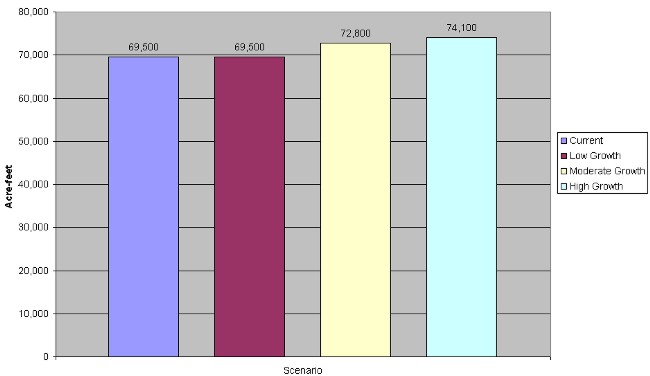
Summary of Findings
Estimates and projections of the consumptive use of surface irrigation water in the Northeast Wyoming River Basins are summarized in Figure 6 for current conditions and three future scenarios. The consumptive use estimates for the three future scenarios are for the year 2030. The first bar in Figure 6 shows that current consumptive use averages about 69,500 acre-feet annually, although consumption can be higher in a wet year and lower in a dry year. The second bar shows that for the low growth scenario, irrigation water use will remain constant at an average of 69,500 acre-feet annually through the year 2030. No additional increases are projected for the low growth scenario because, under current economic conditions, WWDC funding criteria, and compact restrictions, Northeast Wyoming River Basins irrigators have no incentives to pursue the construction of new storage facilities or bring idle lands into production.
The third bar in Figure 6 shows that for the moderate growth scenario, consumptive irrigation water use is expected to rise to 72,800 acre-feet annually by the year 2030. This scenario assumes that cattle prices rise significantly in the future as projected by the U.S. Department of Agriculture in response to export demand for high quality U.S. beef for the overseas restaurant and resort market. As a consequence, irrigators in the planning area will have incentives to maximize production by increasing irrigation efficiency and bringing idle lands into production when storage water is available in Keyhole Reservoir.
The fourth bar in Figure 6 shows that for the high growth scenario, consumptive irrigation water use is expected to rise to 74,100 acre-feet annually by the year 2030. This scenario assumes that, in addition to rising cattle process and more favorable WWDC financing terms, forage prices will increase to the point where forage production for markets outside of the planning area will become profitable. As a consequence, there will be incentives to increase irrigation efficiencies even further as well as develop 3,000 acre-feet of additional storage in small projects on the lower tributaries of the Belle Fourche River.
Figure 6
Summary of Surface Irrigation Water Consumptive Use
Northeast Wyoming River Basins 2030
REFERENCES
HKM Engineering Inc. 2002a. Northeast Wyoming River Basins Plan: Irrigated Lands Mapping and Water Rights Data, Task 2A. Technical Memorandum prepared for the Wyoming Water Development Commission. February.
HKM Engineering Inc. 2002b. Northeast Wyoming River Basins Plan: Agricultural Water Use, Task 2A. Technical Memorandum prepared for the Wyoming Water Development Commission. February.
HKM Engineering Inc. 2002c. Northeast Wyoming River Basins Plan: Storage Operation and Description, Task 2F. Technical Memorandum prepared for the Wyoming Water Development Commission. February.
HKM Engineering Inc. 2002d. Northeast Wyoming River Basins: Available Surface Water Determination, Task 3D. Technical Memorandum prepared for the Wyoming Water Development Commission. February.
Sedivec, Kevin. 1996. Determining Pasture Rental Rates. North Dakota State University Extension Service Publication R-1092. May.
Tyrrell, Pat. 2000. Personal Communication. States West Water Resources Corporation. August 14.
U.S. Department of Agriculture. 2000. USDA 2000 Baseline Projections, Livestock. Economic Research Service. February.
Watts and Associates, Inc. 2002. Northeast Wyoming River Basins Plan: Industrial Water Needs Projections, Task 4. Technical Memorandum prepared for the Wyoming Water Development Commission. February.
Western Research Corporation. 1989. An Economic Analysis of Sandstone Dam and Reservoir. Report to the Wyoming Water Development Commission. January.
Wyoming Agricultural Statistics Service. 2000. Wyoming Agricultural Statistics. Annual bulletins covering the period from 1980 through 2000.