Wyoming State Water Plan
Wyoming State Water Plan
Wyoming Water Development Office
6920 Yellowtail Rd
Cheyenne, WY 82002
Phone: 307-777-7626

Wyoming Water Development Office
6920 Yellowtail Rd
Cheyenne, WY 82002
Phone: 307-777-7626


| SUBJECT: |
Appendix A Irrigation Diversion Operation and Description |
| PREPARED BY: | HKM Engineering Inc. |
| DATE: | March 2002 |
INTRODUCTION
In accordance with the scope of services, an inventory of the diversions located within the Northeast Wyoming River Basins was completed. This inventory is intended to be used for future planning and to provide information for a water availability model of the basin.
DIVERSION SELECTION
The initial selection of diversions to be inventoried was based on a review of the Hydrographers Annual Reports. Those ditches with a recorded diversion of 10 cfs or greater were selected. Because the Northeast Wyoming River Basins is typified by pumped diversions rather than typical gravity diversions, there is a significant lack of diversion records available from the State Engineer.s Office.s Annual Reports. As a result, selection criteria fell largely to State Engineer.s Office water commissioners and area landowners.
METHODOLOGY
Data Gathering
Each of the major diversions listed were visited, with photographs and GPS locations taken of the diversion and flow measurement structures if they existed. Area landowners were contacted to help locate and substantiate data. Field personnel used a Garmin GPS II Plus handheld GPS unit to fix the locations of structures. The removal of the selective availability dithering in May, 2000 and the receiver.s capacity for averaging readings over time gave this handheld GPS receiver the ability to receive locations to within ?12 feet in many cases. These measurements are provided for general location purposes only; no guarantee can be made of their accuracy.
Compilation of Diversion Records
In accordance with the scope of services, diversion records have been compiled for the selected ditches as defined in the preceding section. The diversion records when associated with the acreage served will provide a basis for understanding the actual water use for irrigation in the study area. Unfortunately, as mentioned above, diversion records are sorely lacking for the entire Northeast Wyoming River Basins. Actual water use is commonly significantly less than theoretical water use based on crop consumptive irrigation requirements. This is expected to be especially true within this study area, where forage crops rather than cash crops constitute the predominant demand for irrigation water. Information on actual monthly water use for irrigation is important to the development of water availability models that realistically simulate existing conditions in the area.
Records of ditch diversions are available as summarized below.
Major diversions included in subsequent summaries (Figure 1):
| Name of Site | Sub-Basin | Source | Headgate Location | |
|---|---|---|---|---|
| Lat. | Long. | |||
| Murray Ditch | Belle F. | Redwater Creek | N 44° 33' 36.2" | W 104° 4' 53.0 |
| Cheyenne River | Belle F. | Cheyenne River | Various river pumps | |
| Belle Fourche River | Belle F. | Belle Fourche | Various river pumps | |
BELLE FOURCHE RIVER DRAINAGE
INTRODUCTION
BACKGROUND
The Belle Fourche collects water from approximately 125 miles to the southwest of the northeast corner of Wyoming, on the eastern slope of the Pumpkin Buttes. It crosses the South Dakota state line northeast of Aladdin, Wyoming. It is bordered on the north by the drainages of the Little Missouri, the Little Powder, and the Powder. On the south, it is bordered by the drainages of Hay Creek, Beaver Creek, and the Cheyenne. Of the drainages in the Northeast Wyoming River Basins, the Belle Fourche is the only major one with any significant influence from snowpack melt (from the Bear Creek Mountains). The Belle Fourche.s flows are also controlled by Keyhole Reservoir, a major federal storage facility approximately halfway down the river.s length in Wyoming.
CHARACTERISTICS
Early rights on the Belle Fourche were on the tributaries to the river because flooding made irrigation or diversion on the main stem difficult. Keyhole Reservoir.s influence has been to see those early rights changed to points of diversion out of the main stem. Because the Belle Fourche is still a .flashy. river (subject to large, sudden flows) and because the channel is deeply incised, irrigators prefer portable irrigation (pumps). Few choose to construct diversion dams in the river to raise it into a diversion point. As a result, the Belle Fourche behaves like a conveyance ditch, with irrigators lifting water to laterals with their pumps.
The Belle Fourche most likely charges the free-flowing springs near Hulett. Large seepage losses have been the subject of much study over the years, particularly around the river.s bend to the southeast in the bentonite country just before it leaves the state. Because the channel skirts the Powder Basin uplift and cuts the incline, it encounters the gamut of soils. It also passes through groves of cottonwood trees, which are implicated in those river transmission losses, thanks to their tremendous rate of transpiration.
Keyhole Reservoir.s presence makes it easy to break the river into two distinct operations: upper Belle Fourche, where flows have historically been unpredictable, and lower Belle Fourche, where flows are much more regulated.
Produced water from coal bed methane drilling operations could have a significant impact on the available flow of the Belle Fourche River, not only by providing a constant base flow, but also by potentially increasing the annual storage in Keyhole. Estimates of the impact of this produced water vary widely. (Information gathered for the Industrial Use memorandum of this study indicates that just less than 33,000 af of water was produced from Feb. 2000-Jan. 2001 in the entire Northeast Wyoming River Basin. How much of this water entered Keyhole Reservoir is unknown.) In the past, Keyhole.s yield has varied widely.
One irrigator was careful to point out that the volume of water in unpermitted stock reservoirs could be larger than that of Keyhole Reservoir itself. In addition, the underutilized prior appropriations that used to be diverted from tributaries offer a plentiful allocation of water for Wyoming - particularly in light of the plateau in irrigation development seen in this state.
These factors could become important because under the 1943 Belle Fourche River Compact between Wyoming and South Dakota, all unappropriated water from the date of the compact on are split, 10 percent for Wyoming and 90 percent for South Dakota. Stock water storage (which cannot be larger than 20 acre-feet) is excepted from the terms of the compact. Stock water storage belongs entirely to the State of Wyoming.
USAGE
The Belle Fourche.s waters are permitted primarily for irrigation, though they also have stock, domestic, fire-fighting, and mill uses.
Regulation
Because the Belle Fourche is unpredictable, its diversions are not closely monitored and are not typically regulated by the Wyoming State Engineer.s Office.
Agriculture
Irrigators typically use the water to grow animal feed only. They tend to plant approximately 40 percent alfalfa, 45 percent grass, and 15 percent wheat, oats, or sorghum for small-grain feed.
Irrigation Practices
Because pumps play such a starring role in irrigation on the Belle Fourche, energy prices can affect irrigation dramatically. In general, irrigators tend to use 75 percent flood irrigation (pumped water into ditch-flood system), 20 percent sprinklers, and 5 percent gated pipe.
The typical irrigation season runs from mid-May (depending on whether the spring runoff is delayed by colder weather) to the first week in September (depending on when the first snows fall and the ground freezes).
Double Appropriation
Irrigation water rights with priority dates of March 1, 1945 or earlier are entitled to an additional 1 cfs per 70 acres under Wyoming.s surplus water statutes. Whenever the supply in a stream exceeds the amount required to satisfy all existing appropriations established prior to March 1, 1985, the stream is said to be in an excess flow condition and water right holders with priorities between March 2, 1945 and March 1, 1985 may use an additional 1 cfs for each 70 acres irrigated.
On the Belle Fourche drainage, approximately 75 percent of the irrigators have sized their pumps to divert double appropriation, 90 percent can divert 150 percent of their appropriation, and all can divert their appropriation.
Permitted Uses
Permits granted for water appropriation are granted for specific uses. The following pages contain tables of permits and their associated uses. The following table provides a key to those uses:
| Code | Use |
|---|---|
| Chem | Chemical |
| Com | Commercial |
| Cul | Culinary |
| D | Domestic |
| Drl | Drilling |
| Eng | Steam Engines |
| Fire | Fire Protection |
| Fish | Fish Propogation |
| F.C. | Flood Control |
| I | Irrigation |
| Ind | Industrial |
| I.F. | Instream Flow |
| Mech | Mechanical |
| Mfg | Manufacturing |
| Mil | Milling |
| Min | Mining |
| Misc | Miscellaneous |
| Mun | Municipal |
| Oil | Oil Refining or Production |
| P.C. | Pollution Control |
| Power | Power Development |
| R.R. | Railroad |
| Rec | Recreational |
| Ref | Refining |
| Res. Supply | Supply Facility for a Reservoir |
| S | Stock |
| T | Transportation |
WATER RIGHTS
The water rights summary table included in the body of the diversion synopsis refers to the rights on record with the State Engineer.s Office and is derived from that office.s Tabulation of Adjudicated Surface Water Rights of the State of Wyoming, Water Division Number Two (Oct. 1999). Because this rights summary is pulled directly from the SEO Tab, the rights cited follow the SEO.s priority order:
| Hierarchy | Format of right | Example |
|---|---|---|
| 1 | Day, Month, Year | 05-15-1884 |
| 2 | Month and Year | 05-00-1884 |
| 3 | Specified Season and Year | Spring 1884 |
| 4 | Year Only | 1884 |
| 5 | Before Year | Before 1884 |
Board orders or court orders may also establish a specific priority.
KEY DIVERSIONS
Diversion: MAIN STEM, BELLE FOURCHE RIVER
Date: 16 Jan. 2001
Note: The main stem of the Belle Fourche behaves much as a conveyance ditch, with irrigators along its length dropping in pumps to pull water to small distribution systems. The flashy nature of the Belle Fourche and its deep incision in the land it passes through preclude the use of permanent structures like headgates.
Diversion Description: Pumping points consist of Crisafulli pumps in the riverbed attached to tractors on the bank or a bank of electric pumps on the river.s edge.
Diversion Location: The pumps described are distributed along the main stem of the Belle Fourche.
Direct Flow Water Rights: The following summary of direct-flow rights includes rights on the main stem of the Belle Fourche and its tributaries.
(Note: .Terr.. denotes a territorial water right, or a right that was permitted before Wyoming became a state.)
| Permit | Priority Date | Permitted Use | Acres | Flow (cfs) |
Cumulative Flow (cfs) |
|---|---|---|---|---|---|
| Terr. | 08-10-1886 | I | 60.00 | 0.86 | 0.86 |
| Terr. | 01-10-1887 | S | 0.00 | 0.14 | 1 |
| Terr. | 01-10-1887 | S | 0.00 | 0.14 | 1.14 |
| Terr. | 04-10-1887 | I | 200.00 | 2.86 | 4 |
| Terr. | 09-08-1887 | I | 480.00 | 6.86 | 10.86 |
| Terr. | 04-27-1888 | D, I | 28.00 | 0.4 | 11.26 |
| Terr. | 04-27-1888 | D, I | 100.00 | 1.43 | 12.69 |
| Terr. | 01-26-1889 | I | 3.00 | 0.04 | 12.73 |
| Terr. | 01-26-1889 | I | 5.00 | 0.07 | 12.8 |
| Terr. | 08-13-1889 | I | 200.00 | 2.86 | 15.66 |
| 236 | 03-14-1892 | I | 5.00 | 0.07 | 15.73 |
| 206E | 06-10-1896 | I | 75.71 | 3.4 | 19.13 |
| 1388 | 12-19-1896 | D, I | 10.00 | 0.13 | 19.26 |
| 1561 | 06-10-1896 | I | 74.00 | 1 | 20.26 |
| 1592 | 09-28-1897 | I | 120.00 | 1.71 | 21.97 |
| 1798 | 04-04-1898 | D, I | 159.25 | 2.14 | 24.11 |
| 1962 | 08-27-1898 | I | 127.00 | 1.81 | 25.92 |
| 1963 | 08-27-1898 | I | 55.00 | 0.78 | 26.7 |
| 1949 | 08-30-1898 | I | 100.00 | 1.43 | 28.13 |
| 1949 | 08-30-1898 | I | 140.00 | 2 | 30.13 |
| 436E | 06-12-1899 | I | 73.00 | 1.04 | 31.17 |
| 2987 | 01-07-1901 | I | 75.00 | 1.05 | 32.22 |
| 797E | 02-26-1902 | D, I | 70.00 | 1 | 33.22 |
| 987E | 01-23-1903 | I | 130.00 | 1.86 | 35.08 |
| 1213E | 06-03-1904 | I | 120.00 | 1.71 | 36.79 |
| 6047 | 06-09-1904 | I | 32.00 | 0.45 | 37.24 |
| 6207 | 09-03-1904 | I | 8.50 | 0.12 | 37.36 |
| 6208 | 09-03-1904 | I | 16.50 | 0.23 | 37.59 |
| 6545 | 03-06-1905 | I | 10.00 | 0.14 | 37.73 |
| 6541 | 03-17-1905 | I | 76.00 | 1.08 | 38.81 |
| 7402 | 08-08-1906 | I | 52.50 | 0.75 | 39.56 |
| 7403 | 08-08-1906 | I | 41.20 | 0.58 | 40.14 |
| 7836 | 03-18-1907 | I | 15.00 | 0.21 | 40.35 |
| 7837 | 03-18-1907 | I | 12.00 | 0.17 | 40.52 |
| 7844 | 03-18-1907 | I | 14.00 | 0.2 | 40.72 |
| 7845 | 03-18-1907 | I | 37.00 | 0.52 | 41.24 |
| 8027 | 10-05-1907 | I | 72.50 | 1.04 | 42.28 |
| 1816E | 01-18-1908 | I | 20.00 | 0.28 | 42.56 |
| 8209 | 02-06-1908 | I | 16.00 | 0.22 | 42.78 |
| 1949E | 09-14-1908 | I | 56.25 | 0.8 | 43.58 |
| 9013 | 04-12-1909 | I | 175.00 | 2.5 | 46.08 |
| 9289 | 07-31-1909 | I | 114.64 | 1.64 | 47.72 |
| 9296 | 08-19-1909 | I | 140.00 | 2 | 49.72 |
| 9915 | 06-20-1910 | I, S | 57.00 | 1.81 | 50.53 |
| 9916 | 06-20-1910 | I, S | 51.00 | 0.73 | 51.26 |
| 2363E | 08-25-1910 | I | 5.00 | 0.07 | 51.33 |
| 2301E | 09-28-1910 | I | 144.00 | 2.06 | 53.39 |
| 10549 | 02-16-1911 | D, I | 61.00 | 0.87 | 54.26 |
| 10550 | 02-16-1911 | D, I | 37.00 | 0.52 | 54.78 |
| 10603 | 04-24-1911 | I | 38.00 | 0.54 | 55.32 |
| 10873 | 07-22-1911 | I | 102.00 | 1.46 | 56.78 |
| 10908 | 08-24-1911 | I | 40.50 | 0.58 | 57.36 |
| 10909 | 08-24-1911 | I | 37.00 | 0.53 | 57.89 |
| 10854 | 11-07-1911 | I | 242.00 | 3.46 | 61.35 |
| 11420 | 07-27-1912 | I | 100.00 | 1.42 | 62.77 |
| 11421 | 07-27-1912 | I | 55.00 | 0.78 | 63.55 |
| 11628 | 12-19-1912 | I | 43.00 | 0.61 | 64.16 |
| 11938 | 07-21-1913 | I | 50.00 | 0.71 | 64.87 |
| 11957 | 08-04-1913 | I | 117.50 | 1.68 | 66.55 |
| 11957 | 08-04-1913 | I | 152.00 | 2.17 | 68.72 |
| 11976 | 08-22-1913 | D, I, Mil | 3.50 | 0.05 | 68.77 |
| 12407 | 05-08-1914 | D, I, S | 28.00 | 0.4 | 69.17 |
| 12409 | 05-16-1914 | I | 2.00 | 0.02 | 69.19 |
| 12411 | 05-16-1914 | D, I | 23.90 | 0.34 | 69.53 |
| 12927 | 12-21-1914 | D, I | 2.50 | 0.03 | 69.56 |
| 12928 | 12-21-1914 | D, I | 31.50 | 0.44 | 70 |
| 12929 | 12-21-1914 | D, I | 69.00 | 0.99 | 70.99 |
| 12930 | 12-21-1914 | D, I | 49.00 | 0.7 | 71.69 |
| 15632 | 06-30-1919 | I | 11.80 | 0.16 | 71.85 |
| 15633 | 06-30-1919 | I | 13.00 | 0.19 | 72.04 |
| 15634 | 06-30-1919 | I | 10.00 | 0.14 | 72.18 |
| 19054 | 11-12-1938 | I, S | 140.00 | 2 | 74.18 |
| 19739 | 06-26-1942 | D, Fire, I, Rec | 28.00 | 0.05 | 74.23 |
| 20178 | 08-02-1948 | I | 27.00 | 0.39 | 74.62 |
| 20179 | 08-02-1948 | I | 104.90 | 1.50 | 76.12 |
| 20180 | 08-02-1948 | I | 108.10 | 1.54 | 77.66 |
| 20220 | 10-25-1948 | I | 210.21 | 3 | 80.66 |
| 20294 | 07-18-1949 | I | 68.70 | 0.98 | 81.64 |
| 20393 | 01-16-1950 | I | 98.28 | 1.4 | 83.04 |
| 20394 | 01-16-1950 | I | 63.07 | 0.9 | 83.94 |
| 20395 | 01-16-1950 | I | 79.57 | 1.14 | 85.08 |
| 20396 | 01-16-1950 | I | 63.53 | 0.9 | 85.98 |
| 20397 | 01-16-1950 | I | 67.52 | 0.96 | 86.94 |
| 20398 | 01-16-1950 | I | 94.15 | 1.34 | 88.28 |
| 20399 | 01-16-1950 | I | 94.10 | 1.34 | 89.62 |
| 20400 | 01-16-1950 | I | 76.92 | 1.09 | 90.71 |
| 20530 | 11-17-1950 | I | 71.49 | 1.02 | 91.73 |
| 20531 | 11-17-1950 | I | 174.41 | 2.49 | 94.22 |
| 20532 | 11-17-1950 | I | 42.37 | 0.61 | 94.83 |
| 20533 | 11-17-1950 | I | 41.80 | 0.6 | 95.43 |
| 20584 | 01-04-1951 | I | 65.09 | 0.93 | 96.36 |
| 20720 | 03-21-1951 | I | 167.34 | 2.39 | 98.75 |
| 20722 | 03-21-1951 | I | 72.01 | 1.03 | 99.78 |
| 20786 | 05-21-1951 | I | 14.35 | 0.21 | 99.99 |
| 20787 | 05-21-1951 | I | 107.26 | 1.54 | 101.53 |
| 20789 | 05-21-1951 | I | 36.40 | 0.52 | 102.05 |
| 20842 | 06-19-1951 | I | 18.40 | 0.26 | 102.31 |
| 20844 | 06-19-1951 | I | 95.60 | 1.37 | 103.68 |
| 20812 | 07-27-1951 | I | 12.88 | 0.18 | 103.86 |
| 20813 | 07-27-1951 | I | 14.65 | 0.21 | 104.07 |
| 20814 | 07-27-1951 | I | 25.31 | 0.36 | 104.43 |
| 20815 | 07-27-1951 | I | 238.19 | 3.4 | 107.83 |
| 20858 | 11-07-1951 | I | 48.40 | 0.69 | 108.52 |
| 20859 | 11-07-1951 | I | 14.00 | 0.2 | 108.72 |
| 5621E | 12-24-1951 | I | 86.92 | 1.24 | 109.96 |
| 5622E | 12-24-1951 | I | 64.50 | 0.92 | 110.88 |
| 5623E | 12-24-1951 | I | 18.92 | 0.27 | 111.15 |
| 5631E | 07-14-1952 | I | 91.00 | 1.3 | 112.45 |
| 21002 | 07-18-1952 | I | 42.90 | 0.61 | 113.06 |
| 21003 | 07-18-1952 | I | 30.40 | 0.43 | 113.49 |
| 21093 | 07-18-1952 | I | 39.10 | 0.56 | 114.05 |
| 21010 | 07-28-1952 | I | 102.90 | 1.46 | 115.51 |
| 21015 | 07-28-1952 | I | 234.90 | 3.34 | 118.85 |
| 21016 | 07-28-1952 | I | 155.00 | 2.21 | 121.06 |
| 21060 | 09-16-1952 | I | 19.00 | 0.27 | 121.33 |
| 21061 | 09-16-1952 | I | 71.80 | 1.03 | 122.36 |
| 21062 | 09-16-1952 | I | 41.00 | 0.58 | 122.94 |
| 5643E | 10-14-1952 | I | 278.00 | 3.97 | 126.91 |
| 5671E | 12-29-1952 | I | 69.00 | 0.99 | 127.9 |
| 21166 | 01-02-1953 | I | 47.50 | 0.68 | 128.58 |
| 22283 | 08-28-1957 | I | 70.00 | 1 | 129.58 |
| 22285 | 01-08-1958 | I | 156.00 | 2.23 | 131.81 |
| 22286 | 01-08-1958 | I | 38.00 | 0.54 | 132.35 |
| 22287 | 01-08-1958 | I | 53.50 | 0.77 | 133.12 |
| 22218 | 02-11-1960 | I | 96.70 | 1.38 | 134.5 |
| 22219 | 02-11-1960 | I | 57.21 | 0.82 | 135.32 |
| 22224 | 03-30-1961 | I | 92.40 | 1.32 | 136.64 |
| 22389 | 07-21-1961 | I | 295.70 | 4.22 | 140.86 |
| 22394 | 07-21-1961 | I | 387.50 | 5.54 | 146.4 |
| 22662 | 08-21-1961 | I | 80.80 | 1.16 | 147.56 |
| 6078E | 03-27-1963 | I | 190.00 | 2.71 | 150.27 |
| 22904 | 08-15-1966 | I | 111.40 | 1.59 | 151.86 |
| 23378 | 04-09-1968 | I, S | 91.46 | 1.31 | 153.17 |
| 23518 | 12-22-1970 | I | 22.40 | 0.32 | 153.49 |
| 23519 | 12-22-1970 | I | 44.50 | 0.65 | 154.14 |
| 23520 | 12-22-1970 | I | 125.70 | 1.8 | 155.94 |
| 23694 | 06-01-1971 | I | 65.00 | 0.93 | 156.87 |
| 23664 | 06-28-1971 | I | 37.50 | 0.54 | 157.41 |
| 23654 | 07-23-1971 | I | 108.40 | 1.54 | 158.95 |
| 23655 | 07-23-1971 | I | 119.50 | 1.71 | 160.66 |
| 23665 | 08-17-1971 | I | 23.70 | 0.34 | 161 |
| 23666 | 08-17-1971 | I | 19.30 | 0.6 | 161.26 |
| 23746 | 12-14-1971 | I | 141.00 | 2.01 | 163.27 |
| 6580E | 11-12-1975 | I | 37.24 | 0.53 | 163.8 |
| 6581E | 11-12-1975 | I | 75.89 | 1.08 | 164.88 |
| 24956 | 12-18-1975 | I | 381.00 | 5.44 | 170.32 |
| 25441 | 05-10-1977 | I | 107.00 | 1.53 | 171.85 |
| 26481 | 06-18-1979 | I | 66.40 | 0.94 | 172.79 |
| 26947 | 06-20-1979 | I | 52.86 | 0.76 | 173.55 |
| 26948 | 06-20-1979 | I | 14.41 | 0.2 | 173.75 |
| 28217 | 07-20-1981 | I | 164.30 | 2.34 | 176.09 |
| 29011 | 05-21-1982 | D, S | 0.00 | 0.05 | 176.14 |
| 28715 | 09-23-1982 | I | 12.79 | 0.18 | 176.32 |
| 28667 | 04-14-1983 | I | 43.10 | 0.61 | 176.93 |
| 28249 | 04-22-1983 | I | 43.80 | 0.63 | 177.56 |
Note: The building of Keyhole Reservoir in 1952 meant regulation of the Belle Fourche River.s flows below the reservoir. Nevertheless, according to State Board of Control member and Div. II superintendent Mike Whitaker, few landowners have chosen to move their points of use (POUs) from the tributaries they originally filed the rights on to the main stem of the Belle Fourche. To encompass all the diversions taking Belle Fourche water, rights on the main stem and all its tributaries are included above.
Associated Storage Rights: The Belle Fourche Irrigation District was formed to buy Wyoming.s supplemental supply in Keyhole Reservoir. The 18 members of that district are still paying the state for their interest in the reservoir.
Losses: Previous studies have approximated the losses in the Belle Fourche from Keyhole to the state line at 50 percent in dry conditions, approximately 40 percent in a wet year.
References: Crook County Irrigation District president and Belle Fourche irrigator Skip Waters, interview, 15 Jan. 2001.
CHEYENNE RIVER DRAINAGE
INTRODUCTION
BACKGROUND
The Cheyenne collects streams from the draws and gullies as far west as the east slope of the Pine Ridge Mountains northeast of Casper, Wyoming, as far south as the north slope of Hat Creek Breaks, and is bordered on the north by the Beaver Creek and Belle Fourche drainages. It depends on snowmelt and rainfall for runoff, rather than the snowmelt that regulates flows to the west. The water it generates crosses the South Dakota state line to be joined by Beaver Creek. The Cheyenne River has never had a compact ratified defining Wyoming and South Dakota.s interests in it.
CHARACTERISTICS
As the Cheyenne River winds through the arid landscape, the waters delivered into South Dakota can be charged with salts and silt. In the Cheyenne River drainage, irrigators pay close attention to the color of the water. .Clear water. is harmful to crops because flows have slowed enough to drop silt and pick up salts from the clays in the watershed. In contrast, .silt water,. the opaque runoff immediately generated by storms, is more desirable.
Because the Cheyenne traverses a semi-arid landscape, it can be .flashy,. subject to large, rapid runoff that has the capacity to bring trees and other large flotsam with it. Headgates are largely unknown on the river and its tributaries because of their tendency to be damaged or destroyed in these storm flows. Instead, irrigators favor pumping points that can be removed and replaced in the stream or spreader dikes that reduce the velocity and depth of flow, spreading the water across fields.
Particularly in the tributary streams (Lightning, Old Woman, and Lance creeks, for example), practices have changed in the past few decades. In the 1960s and 1970s, the former Soil Conservation Service funded the construction of stock water reservoirs and spreader dikes.
Range management practices have also changed over time. Today, ranchers rotate their cattle grazing operations to allow grasses to grow back. The stock dams in the tributaries remain, and spreader dikes continue to function. The net result is to regulate the runoff, reducing peak flows and maintaining year- round flow in the larger tributaries.
USAGE
The Cheyenne.s waters are permitted for irrigation, stock, and domestic use.
Regulation
At this writing, the State Engineer.s Office does not currently have a water commissioner in the Northeast Wyoming River Basins. But even when one is present, the lack of gaging stations or flumes and the flashy nature of the drainage incapacitates the SEO.s primary regulatory tool: monitoring. The area typically does not fall under regulation. As one irrigator noted, when an irrigator has water, every irrigator has water.
Agriculture
In general, irrigators are using the water for hay only. They can pump water onto alfalfa fields or use flood methods for western wheat grass, but crops are typically raised for consumption on the individual ranches.
Growers in the Cheyenne River drainage tend to plant acreage as approximately 90 percent western wheat grass hay and 10 percent alfalfa.
Irrigation Practices
See the diversion summary below.
The typical irrigation season runs from April 15-May 1 (depending on whether the spring runoff is delayed by colder weather) to early October (depending on when the first snows fall and the ground freezes).
Double appropriation
Irrigation water rights with priority dates of March 1, 1945 or earlier are entitled to an additional 1cfs per 70 acres under Wyoming.s surplus water statutes. Whenever the supply in a stream exceeds the amount required to satisfy all existing appropriations established prior to March 1, 1985, the stream is said to be in an excess flow condition and water right holders with priorities between March 2, 1945 and March 1, 1985 may use an additional 1 cfs for each 70 acres irrigated.
On the Cheyenne River drainage, irrigators essentially use the double appropriation doctrine through their spreader dikes. They utilize all available water when it is available. Pumps, too, are sized to divert twice the appropriation when it is available.
Permitted Uses
Permits granted for water appropriation are granted for specific uses. The following pages contain tables of permits and their associated uses. The following table provides a key to those uses:
| Code | Use |
|---|---|
| Chem | Chemical |
| Com | Commercial |
| Cul | Culinary |
| D | Domestic |
| Drl | Drilling |
| Eng | Steam Engines |
| Fire | Fire Protection |
| Fish | Fish Propogation |
| F.C. | Flood Control |
| I | Irrigation |
| Ind | Industrial |
| I.F. | Instream Flow |
| Mech | Mechanical |
| Mfg | Manufacturing |
| Mil | Milling |
| Min | Mining |
| Misc | Miscellaneous |
| Mun | Municipal |
| Oil | Oil Refining or Production |
| P.C. | Pollution Control |
| Power | Power Development |
| R.R. | Railroad |
| Rec | Recreational |
| Ref | Refining |
| Res. Supply | Supply Facility for a Reservoir |
| S | Stock |
| T | Transportation |
WATER RIGHTS
The water rights summary table included in the body of the diversion synopsis refers to the rights on record with the State Engineer.s Office and is derived from that office.s Tabulation of Adjudicated Surface Water Rights of the State of Wyoming, Water Division Number Two (Oct. 1999). Because this rights summary is pulled directly from the SEO Tab, the rights cited follow the SEO.s priority order:
| Hierarchy | Format of right | Example |
|---|---|---|
| 1 | Day, Month, Year | 05-15-1884 |
| 2 | Month and Year | 05-00-1884 |
| 3 | Specified Season and Year | Spring 1884 |
| 4 | Year Only | 1884 |
| 5 | Before Year | Before 1884 |
Board orders or court orders may also establish a specific priority.
KEY DIVERSIONS
Diversion: MAIN STEM, CHEYENNE RIVER
Date: 16 Jan. 2001
Note: The main stem of the Cheyenne behaves much as a conveyance ditch, with irrigators along its length dropping in pumps to pull water to distribution systems. The flashy nature of the Cheyenne and the depth of the channel preclude the use of permanent diversion structures and conventional headgates.
| Diversion Description: Pumping points consists of a Crisafulli pump on the river bed attached to a tractor on the bank or a bank of electric pumps on the river edge. Along the length of the lower main stem, the Cheyenne has two 16-inch Crisafullis, six 12-inch Crisafullis, one 8-inch Crisafulli, and two 8-inch electrical centrifugal pumps. |  12-inch Crisafulli (attached to tractor) and eight-inch electrical centrifugal pump (foreground) |
| Diversion Location: The pumps described are placed along the main stem of the Cheyenne. The location given is for the last diversion out of the river before it leaves the state, and includes two electric centrifugals and one 12-inch Crisafullis. |
According to a pump manufacturer, Crisafulli pumps have the following capacities (new):
| Pump Size (in.) |
Flow (gpm) at 10 ft. of head | Flow (gpm) at 20 ft. of head |
|---|---|---|
| 8 | 3000 | 2450 | 12 | 5000 | 3750 | 16 | 9500 | 8000 |
Though the river can cut a deep channel, most of the diversions are likely to only be pushing 10 feet of static head.
Headgate:
Lat. N 43° 25' 54.2''
Long. W 104° 11' 32.9''
Conveyance Description: The Cheyenne cuts through sand and clay. As one irrigator put it, .We.ve got gumbo to the north and sand to the south [of the river]..
The river has deposited much sand and silt in its bed in the past, making much of its flows subsurface, where irrigators can.t access them.
The river runs above the surface of the channel three times a year on average and at least once a year even in dry years. Irrigators note that the length of the .runs. seem to be independent of a wet, average, or dry years.
Just this year (2001), irrigators have seen more water running more constantly down the bed of the river. They attribute this flow to coal bed methane drilling activity in the Lance and Black Thunder creek drainages.
Direct Flow Water Rights: The State Engineer.s Office shows no permitted direct-flow rights on the Cheyenne. The only rights evident are on tributaries to the river.
Associated Storage Rights: As noted in the introduction, the Cheyenne River.s tributaries are larded with numerous flood storage reservoirs.
Return Flows: Irrigators were not able to provide return flow estimates. They note that silt lines the ditches, reducing percolation through the sand on the south side, but water applied to fields will seep in immediately. This indicates fairly high return flow rates, depending on the distance from the field to the riverbed.
Losses: Because losses occur once the irrigator has put the water into distribution channels around fields, losses are dependent upon the field in question. Estimates were not available.
References: Fred and Clara Wilson, irrigators, personal interview, 16 Jan. 2001.
REDWATER CREEK DRAINAGE
INTRODUCTION
BACKGROUND
Redwater Creek carries water from the Bear Lodge Mountains into South Dakota to the east in a fairly short and straight run in Wyoming. It travels across some extremely porous soils, but gains volume with distance from its source. Because the stream travels a fault system, water is lost to the underlying alluvium, resurfacing downstream in several places. As a tributary to the Belle Fourche, Redwater Creek and its tributaries and diversions fall under the control of the Belle Fourche Compact with South Dakota.
CHARACTERISTICS
Redwater Creek begins in the Bear Lodge Mountains, and so it receives the benefit of some of the snow pack in those mountains. But its biggest and most constant source comes from South Dakota as .new water. from the Madison Aquifer that emerges in Sand Creek, a tributary to Redwater Creek. Sturgis and Rapid City-area aquifer development have reduced flows out of the Madison aquifer and into Redwater considerably over the past few years. According to rancher Gene Reineke, forest growth has probably also lessened the flow in Redwater, taking more water for evapotransporation. Reineke points out that the North and South forks of Redwater Creek are dry most of the time as evidence of his hypothesis.
USAGE
Redwater Creek.s waters are permitted for irrigation, stock, domestic use, ore milling, fire fighting, and fish culture.
Regulation
The proximity of South Dakota means that irrigators on Redwater Creek are not called into regulation. Even ditches like the Murray, which crosses the state line at approximately one-third of its length, don.t suffer because of the recharge from subsurface flows and the decline of irrigation in the area.
Agriculture
In general, irrigators are using the water for forage production only. They tend to plant approximately 70 percent alfalfa, 20 percent grass, and 10 percent oats or millet for small-grain feed.
Irrigation Practices
Though the area had much sprinkler and gated pipe activity 15 or 20 years ago, it has changed to become entirely irrigated with ditch-flood practices.
In wet years, irrigators will use only approximately 50 percent of their rights and grow dryland hay. In dry years, they utilize those rights to the maximum extent possible to irrigate the hay. As one irrigator put it, .People irrigate when they need it.. Irrigation is expensive, even if it.s ditch-flood; labor is difficult to obtain.
Finally, the area is seeing a decline in irrigation because of changes in ownership. New owners typically are not concerned with irrigating and producing a good crop as much as they are in speculating on the land or making a living in the relatively nearby South Dakota cities.
The typical irrigation season runs from mid-April (depending on whether the spring runoff is delayed by colder weather) to early October (depending on when the first snows fall and the ground freezes).
Double Appropriation
Irrigation water rights with priority dates of March 1, 1945 or earlier are entitled to an additional 1cfs per 70 acres under Wyoming.s surplus water statutes. Whenever the supply in a stream exceeds the amount required to satisfy all existing appropriations established prior to March 1, 1985, the stream is said to be in an excess flow condition and water right holders with priorities between March 2, 1945 and March 1, 1985 may use an additional 1 cfs for each 70 acres irrigated.
On the Redwater drainage, only the Murray can carry as much as 150 percent of its appropriations.
Permitted Uses
Permits granted for water appropriation are granted for specific uses. The following pages contain tables of permits and their associated uses. The following table provides a key to those uses:
| Code | Use |
|---|---|
| Chem | Chemical |
| Com | Commercial |
| Cul | Culinary |
| D | Domestic |
| Drl | Drilling |
| Eng | Steam Engines |
| Fire | Fire Protection |
| Fish | Fish Propogation |
| F.C. | Flood Control |
| I | Irrigation |
| Ind | Industrial |
| I.F. | Instream Flow |
| Mech | Mechanical |
| Mfg | Manufacturing |
| Mil | Milling |
| Min | Mining |
| Misc | Miscellaneous |
| Mun | Municipal |
| Oil | Oil Refining or Production |
| P.C. | Pollution Control |
| Power | Power Development |
| R.R. | Railroad |
| Rec | Recreational |
| Ref | Refining |
| Res. Supply | Supply Facility for a Reservoir |
| S | Stock |
| T | Transportation |
WATER RIGHTS
The water rights summary table included in the body of the diversion synopsis refers to the rights on record with the State Engineer.s Office and is derived from that office.s Tabulation of Adjudicated Surface Water Rights of the State of Wyoming, Water Division Number Two (Oct. 1999). Because this rights summary is pulled directly from the SEO Tab, the rights cited follow the SEO.s priority order:
| Hierarchy | Format of right | Example |
|---|---|---|
| 1 | Day, Month, Year | 05-15-1884 |
| 2 | Month and Year | 05-00-1884 |
| 3 | Specified Season and Year | Spring 1884 |
| 4 | Year Only | 1884 |
| 5 | Before Year | Before 1884 |
Board orders or court orders may also establish a specific priority.
KEY DIVERSIONS
Diversion: MURRAY DITCH DIVERSION (AKA: Murray at WY-SD State Line, Murray above Headgate)
Date: 1/16/2001
| Diversion Description: Headgate consists of a single, 6 x 1.7-foot steel gate in steel slides operated by a Waterman-type screw in a concrete headwall. Adjacent to the structure (and built onto it) is a concrete-lined ditch section. |  Diversion structure, Murray Ditch |
 Headgate, Murray Ditch |
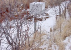 Flume and recorder, Murray Ditch |
Diversion Location: The headgate diverts from the main stem of Redwater Creek, approximately 1.2 miles from the South Dakota border. The headgate is approximately 2.3 miles from the South Dakota border along the Murray Ditch.
Headgate:
Lat. N 44° 33' 36.2''
Long. W 104° 4' 53.0''
Flume:
Lat. N 44° 34' 35.4''
Long. W 104° 3' 19.3''
Conveyance Description: Open channel flowing approximately 2.3 miles in Wyoming from the headgate.
Direct Flow Water Rights: The direct-flow water rights adjudicated in Wyoming in the Murray Ditch are summarized below:
| Permit | Priority Date | Permitted Use | Acres | Flow (cfs) |
Cumulative Flow (cfs) |
|---|---|---|---|---|---|
| Terr. | 11-01-1881 | D, I | 95.47 | 1.36 | 1.36 |
| Terr. | 10-01-1882 | I | 88.89 | 1.27 | 2.63 |
| 306E | 01-21-1898 | I | 40 | 0.57 | 3.20 |
| 5520E | 11-20-1950 | I | 64.62 | 0.92 | 4.12 |
Associated Storage Rights: None
Irrigation Practices: See introduction to Redwater Creek above.
Return Flows: Estimated percentage of return flows:
| Destination | Wet Yr. | Avg. yr. | Dry Yr. |
|---|---|---|---|
| Redwater Creek | 40 | 50 | 50 |
Losses: No information could be provided.
References: Gene Reineke, local landowner and president, Murray Ditch Irrigation Co., Reineke Ranch, interview, 15 Jan. 2001
| Name Source District Data |
Murray Ditch Diversion Redwater Creek 7 Total Monthly flow in AF | ||||||||||||
| Water Year |
Oct | Nov | Dec | Jan | Feb | Mar | Apr | May | Jun | Jul | Aug | Sep | Total |
|---|---|---|---|---|---|---|---|---|---|---|---|---|---|
| 1970 | 977.00 | 20.00 | 0.00 | 0.00 | 0.00 | 0.00 | 0.00 | 2.60 | 13.00 | 751.00 | 888.00 | 381.00 | 3032.60 |
| 1971 | 152.00 | 61.00 | 0.00 | 0.00 | 0.00 | 0.00 | 0.00 | 0.00 | 0.40 | 807.00 | 985.00 | 466.00 | 2471.40 |
| 1972 | 2.80 | 0.00 | 0.00 | 0.00 | 0.00 | 0.00 | 0.00 | 0.00 | 98.00 | 277.00 | 452.00 | 97.00 | 926.80 |
| 1973 | 43.00 | 97.00 | 0.00 | 0.00 | 0.00 | 0.00 | 0.00 | 0.20 | 61.00 | 1100.00 | 861.00 | 60.00 | 2222.20 |
| 1974 | 215.00 | 26.00 | 0.00 | 0.00 | 0.00 | 0.00 | 0.00 | 0.00 | 0.00 | 804.00 | 942.00 | 571.00 | 2558.00 |
| 1975 | 476.00 | 0.00 | 0.00 | 0.00 | 0.00 | 0.00 | 0.00 | 0.00 | 0.00 | 1100.00 | 856.00 | 523.00 | 2955.00 |
| 1976 | 290.00 | 316.00 | 0.00 | 0.00 | 0.00 | 0.00 | 0.00 | 309.00 | 175.00 | 331.00 | 693.00 | 564.00 | 2678.00 |
| 1977 | 136.00 | 0.00 | 0.00 | 0.00 | 0.00 | 0.00 | 0.00 | 0.00 | 442.00 | 813.00 | 1000.00 | 550.00 | 2941.00 |
| 1978 | 779.00 | 131.00 | 0.00 | 0.00 | 0.00 | 0.00 | 0.00 | 2.80 | 179.00 | 622.00 | 508.00 | 717.00 | 2938.80 |
| 1979 | 490.00 | 0.00 | 0.00 | 0.00 | 0.00 | 0.00 | 0.00 | 0.00 | 751.00 | 807.00 | 537.00 | 242.00 | 2827.00 |
| 1980 | 365.00 | 2.60 | 0.00 | 0.00 | 0.00 | 0.00 | 0.00 | 257.00 | 250.00 | 661.00 | 847.00 | 266.00 | 2648.60 |
| 1981 | 408.00 | 129.00 | 0.00 | 0.00 | 0.00 | 0.00 | 175.00 | 549.00 | 330.00 | 756.00 | 610.00 | 366.00 | 3323.00 |
| 1982 | 619.00 | 89.00 | 0.00 | 0.00 | 0.00 | 0.00 | 0.00 | 0.60 | 0.00 | 501.00 | 826.00 | 830.00 | 2865.60 |
| 1983 | 123.00 | 0.00 | 0.00 | 0.00 | 0.00 | 0.00 | 0.00 | 0.00 | 194.00 | 1120.00 | 961.00 | 768.00 | 3166.00 |
| 1984 | 497.00 | 0.00 | 0.00 | 0.00 | 0.00 | 0.00 | 0.00 | 0.00 | 90.00 | 874.00 | 666.00 | 906.00 | 3033.00 |
| 1985 | 61.00 | 4.00 | 0.00 | 0.00 | 0.00 | 0.00 | 0.00 | 858.00 | 907.00 | 604.00 | 851.00 | 861.00 | 4146.00 |
| 1986 | 392.00 | 28.00 | 0.00 | 0.00 | 0.00 | 0.00 | 0.00 | 0.00 | 3.60 | 295.00 | 749.00 | 185.00 | 1652.60 |
| 1987 | 0.00 | 0.00 | 0.00 | 0.00 | 0.00 | 0.00 | 0.00 | 0.00 | 466.00 | 651.00 | 853.00 | 341.00 | 2311.00 |
| 1988 | 0.00 | 0.00 | 0.00 | 0.00 | 0.00 | 0.00 | 0.00 | 298.00 | 825.00 | 527.00 | 890.00 | 759.00 | 3299.00 |
| 1989 | 466.00 | 34.00 | 0.00 | 0.00 | 0.00 | 0.00 | 3.20 | 0.20 | 444.00 | 883.00 | 469.00 | 977.00 | 3276.40 |
| 1990 | 64.00 | 0.00 | 0.00 | 0.00 | 0.00 | 0.00 | 0.00 | 0.00 | 613.00 | 748.00 | 364.00 | 516.00 | 2305.00 |
| 1991 | 1260.00 | 0.00 | 0.00 | 0.00 | 0.00 | 0.00 | 0.00 | 0.90 | 0.00 | 1010.00 | 1120.00 | 110.00 | 3500.90 |
| 1992 | 650.00 | 8.90 | 0.00 | 0.00 | 0.00 | 0.00 | 0.00 | 388.00 | 681.00 | 474.00 | 407.00 | 376.00 | 2984.90 |
| 1993 | 91.00 | 0.00 | 0.00 | 0.00 | 0.00 | 0.00 | 0.00 | 0.00 | 184.00 | 113.00 | 228.00 | 48.00 | 664.00 |
| 1994 | 649.00 | 56.00 | 0.00 | 0.00 | 0.00 | 0.00 | 0.00 | 0.00 | 642.00 | 730.00 | 659.00 | 1120.00 | 3856.00 |
| 1995 | 228.00 | 0.02 | 0.00 | 0.00 | 0.00 | 0.00 | 0.00 | 0.00 | 0.40 | 265.00 | 432.00 | 761.00 | 1686.42 |
| 1996 | 362.00 | 0.00 | 0.00 | 0.00 | 0.00 | 0.00 | 0.00 | 0.00 | 0.00 | 977.00 | 675.00 | 284.00 | 2298.00 |
| 1997 | 0.00 | 0.00 | 0.00 | 0.00 | 0.00 | 0.00 | 5.10 | 0.00 | 0.00 | 721.00 | 395.00 | 588.00 | 1709.10 |
| 1998 | 165.00 | 0.00 | 0.00 | 0.00 | 0.00 | 0.00 | 0.00 | 285.00 | 30.00 | 588.00 | 137.00 | 403.00 | 1608.00 |
| 1999 | 76.00 | 0.00 | 0.00 | 0.00 | 0.00 | 0.00 | 0.00 | 0.00 | 57.00 | 273.00 | 325.00 | 639.00 | 1370.00 |
| Mean | 334.56 | 33.42 | 0.00 | 0.00 | 0.00 | 0.00 | 6.11 | 98.38 | 247.88 | 672.77 | 672.87 | 509.17 | 2575.14 |
| Max | 1260.00 | 316.00 | 0.00 | 0.00 | 0.00 | 0.00 | 1750.00 | 858.00 | 907.00 | 1120.00 | 1120.00 | 1120.00 | 4146.00 |
| Min | 0.00 | 0.00 | 0.00 | 0.00 | 0.00 | 0.00 | 0.00 | 0.00 | 0.00 | 113.00 | 137.00 | 48.00 | 664.00 |
| Name Source District Data |
Murray Ditch Diversion Redwater Creek 7 First & Last Dates, Max Days | ||||||||||||
| Water Year |
First Date of Measurement | Last Date of Measurement | Maximum Days Missing | ||||||||||
|---|---|---|---|---|---|---|---|---|---|---|---|---|---|
| 1970 | 14-May | 17-Nov | 0 | ||||||||||
| 1971 | 28-Jun | 03-Oct | 0 | ||||||||||
| 1972 | 04-Jun | 30-Nov | 0 | ||||||||||
| 1973 | 27-May | 12-Nov | 0 | ||||||||||
| 1974 | 01-Jul | 28-Oct | 0 | ||||||||||
| 1975 | 02-Jul | 27-Nov | 0 | ||||||||||
| 1976 | 14-May | 28-Oct | 0 | ||||||||||
| 1977 | 01-Jun | 08-Nov | 0 | ||||||||||
| 1978 | 04-May | 23-Oct | 0 | ||||||||||
| 1979 | 03-Jun | 27-Nov | 0 | ||||||||||
| 1980 | 19-May | 26-Nov | 0 | ||||||||||
| 1981 | 24-Apr | 20-Nov | 0 | ||||||||||
| 1982 | 19-May | 09-Oct | 0 | ||||||||||
| 1983 | 13-Jun | 29-Oct | 0 | ||||||||||
| 1984 | 09-Jun | 12-Nov | 0 | ||||||||||
| 1985 | 01-May | 08-Nov | 0 | ||||||||||
| 1986 | 09-Jun | 01-Sep | 0 | ||||||||||
| 1987 | 10-Jun | 10-Sep | 0 | ||||||||||
| 1988 | 23-May | 06-Nov | 0 | ||||||||||
| 1989 | 26-Apr | 20-Oct | 0 | ||||||||||
| 1990 | 02-Jun | 28-Oct | 0 | ||||||||||
| 1991 | 22-May | 04-Nov | 0 | ||||||||||
| 1992 | 07-May | 07-Oct | 0 | ||||||||||
| 1993 | 01-Jun | 02-Nov | 0 | ||||||||||
| 1994 | 03-Jun | 01-Nov | 0 | ||||||||||
| 1995 | 21-Jun | 31-Oct | 0 | ||||||||||
| 1996 | 01-Jul | 27-Sep | 0 | ||||||||||
| 1997 | 17-Apr | 24-Oct | 0 | ||||||||||
| 1998 | 11-May | 12-Oct | 0 | ||||||||||
| 1999 | 24-Jun | 30-Sep | 0 | ||||||||||
| Avg. | 28-May | 27-Oct | 0 | ||||||||||
| Earliest | 17-Apr | 01-Sep | 0 | ||||||||||
| Latest | 02-Jul | 30-Nov | 0 | ||||||||||