Wyoming State Water Plan
Wyoming State Water Plan
Wyoming Water Development Office
6920 Yellowtail Rd
Cheyenne, WY 82002
Phone: 307-777-7626

Wyoming Water Development Office
6920 Yellowtail Rd
Cheyenne, WY 82002
Phone: 307-777-7626


A. Introduction
The Northeast Wyoming River Basins Plan was authorized by the Wyoming Legislature in 2000. The objectives of this plan are to:
The intent of this summary report is to describe the planning study in sufficient detail for the reader to gain a general understanding of the investigations that were performed and the results of those investigations. For detailed information on a specific topic the reader is directed to the technical memorandum prepared for that topic. References used in preparing the technical memoranda are not repeated in this summary report. These references are presented in the individual technical memoranda.
B. DescriptionLocation
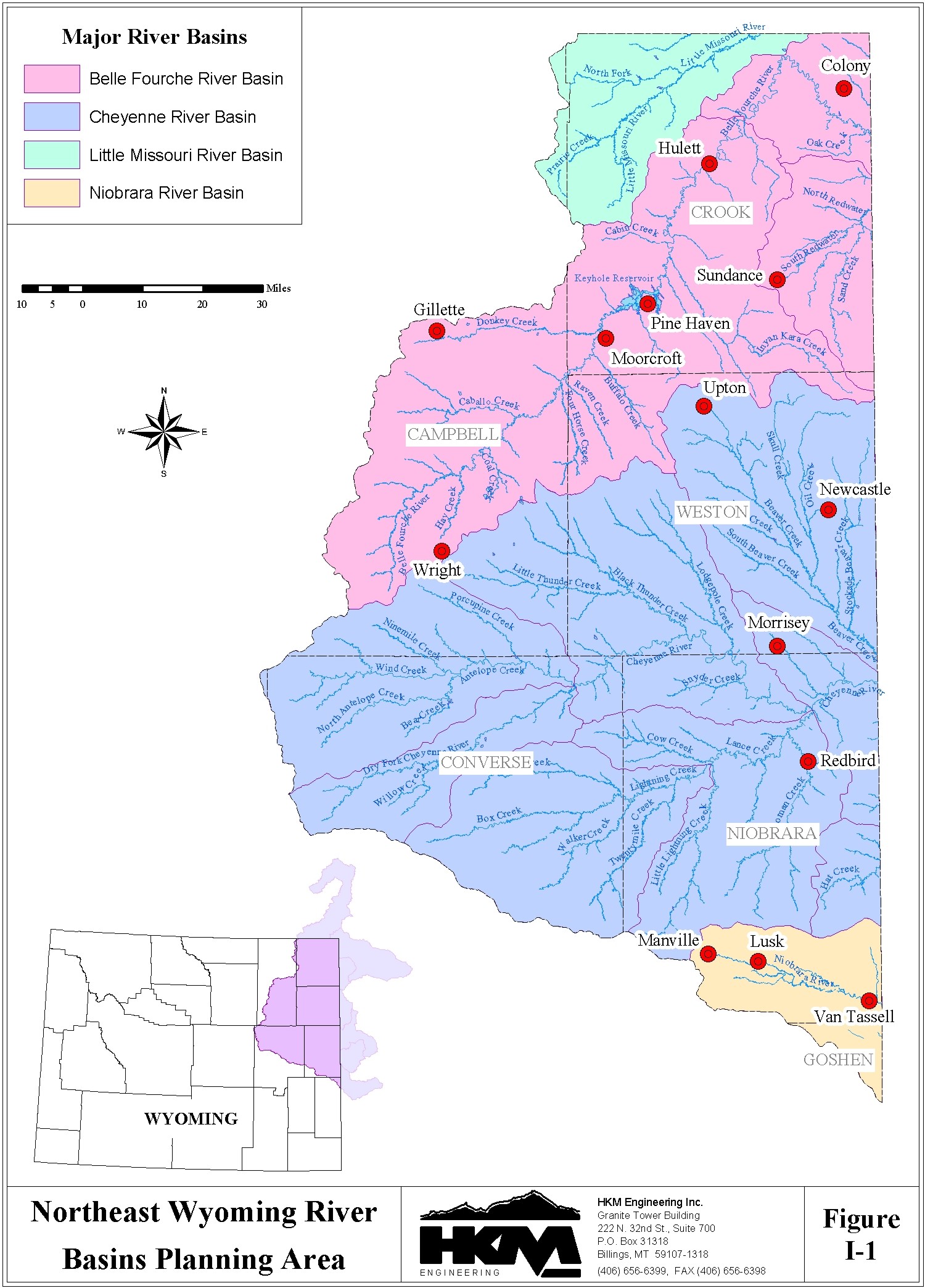
The planning area of the Northeast Wyoming River Basins Plan includes the drainages of the Little Missouri River, Belle Fourche River, Cheyenne River, and Upper Niobrara River. These river basins encompass all or part of Campbell, Crook, Weston, Converse, and Niobrara counties in northeast Wyoming.
The planning area is bounded on the north by the Wyoming-Montana stateline, and on the east by the Wyoming-South Dakota stateline and the Wyoming-Nebraska stateline. The west and south boundaries are the limits of the Little Missouri River, Belle Fourche River, Cheyenne River, and Upper Niobrara River drainages. The planning area is presented in Figure I-1.
Topography
The Little Missouri River flows in a northeast direction into Montana then proceeds through South Dakota and North Dakota before reaching its confluence with the Missouri River. The Belle Fourche River also flows in a northeast direction for most of its length in Wyoming. After approaching within a few miles of the Montana border, the Belle Fourche River abruptly turns to the southeast and crosses the Wyoming-South Dakota stateline and eventually flows into the Cheyenne River in South Dakota. Redwater Creek, with its principal tributary Sand Creek, flows east into South Dakota before joining the Belle Fourche River.
The Cheyenne River in Wyoming flows east into South Dakota where it proceeds in a general northeasterly direction to meet the Missouri River. Beaver Creek, a principal tributary of the Cheyenne River, flows in a southeasterly direction to its confluence with Stockade Beaver Creek a few miles west of the Wyoming-South Dakota stateline. It then proceeds another short distance to join the Cheyenne River in South Dakota.
The Upper Niobrara River flows east and southeast into Nebraska, then east across the northern tier of Nebraska to a confluence with the Missouri River.
Elevations in the planning area range from about 3,500 feet to 6,000 feet in the plains and from about 4,500 to 6,000 feet in the Black Hills portion of the area. The lowest elevation in the planning area, which is also the lowest elevation in Wyoming, is at the point where the Belle Fourche River crosses the Wyoming-South Dakota stateline, elevation 3,125 feet.
Climate
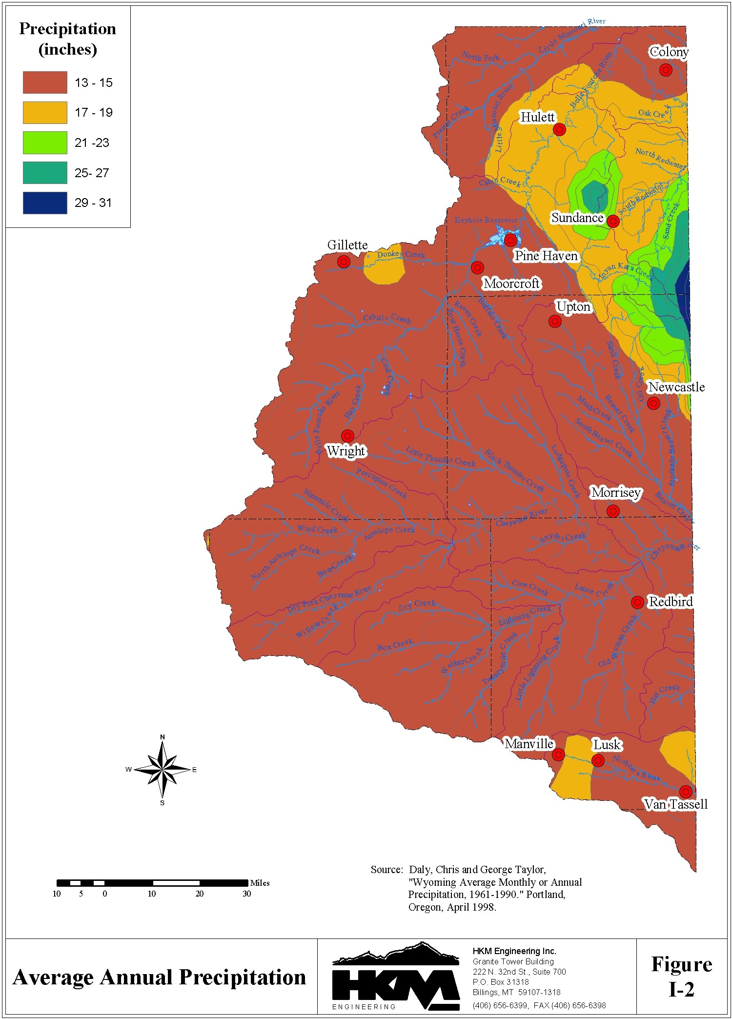
Annual precipitation across the planning area ranges from a low of approximately 13 inches to a high of approximately 30 inches on the eastern boundary in the Black Hills. Average total annual precipitation values between 13 and 15 inches appear to be the norm throughout the majority of the planning area. Figure I-2 describes precipitation characteristics of the planning area.
Water Features
The significant tributaries of the Belle Fourche River include Redwater Creek, Beaver Creek, Blacktail Creek, Lytle Creek, Miller Creek, Inyan Kara Creek, Donkey Creek, and Arch Creek. The major tributaries of the Cheyenne River include Dry Fork Cheyenne River, Antelope Creek, Lightening Creek, Lance Creek, and Beaver Creek. Stockade Beaver Creek is a principal tributary of Beaver Creek.
The largest storage facility developed in the Northeast Wyoming Planning area is Keyhole Reservoir. This impoundment is on the Belle Fourche River northeast of Moorcroft. Other reservoirs having significant capacity include Gillette Reservoir on Donkey Creek, Stone #2 Reservoir on Bonepile Creek, Betty Reservoir on South Fork Cheyenne River, Spencer Reservoir and M.W. Reservoir on Stockade Beaver Creek, Robbers Roost Reservoir on Robbers Roost Creek, Clark & Metzger Reservoir on Alum Creek, Klodt Reservoir on Mush Creek, and Tract 37 Reservoir on North Fork Little Missouri River.
C. Water-Related History of the BasinWater development began in the Northeast Wyoming River Basins when the stock growing industry expanded into the area following the Black Hills Gold Rush in 1875. Raising cattle and sheep required irrigation and soon ranchers were enjoying the cheap irrigation along small streams. In most of the planning area it became apparent storage would be required to enhance the available water supplies to support the expanding livestock industry. A number of small reservoirs were developed to provide the needed supplemental supply for late-season irrigation. In 1952 the U. S. Bureau of Reclamation constructed Keyhole Reservoir to provide irrigation water for Wyoming and South Dakota users.
D. Wyoming Water LawThe Wyoming constitution establishes water in the state to be the property of the state. Consequently, all development and management of water resources in Wyoming is governed by the water laws embodied in the Constitution and Statutes. These water laws are recognized as inviolate in the river basin planning program.
The use of water is administered by the State Engineer and the State Board of Control which consists of the State Engineer and the Superintendent of each of the four water divisions of the state. Water is administered under the prior appropriations doctrine that dictates the water right with a senior or earlier priority date is entitled to receive its full amount before water rights with later, or junior, priority dates receive any of their allocation. The priority date of a water right is established as the date the water right application is filed with the State Engineer. Before water is available for use by a new project all water rights with priority dates senior to the priority of the proposed project need to be satisfied.
E. Interstate CompactsOther significant events in the water history of the basins are the negotiation, adoption, and ratification of the Belle Fourche River Compact in 1943 and the Upper Niobrara River Compact in 1962.
The Belle Fourche River Compact divides the water between Wyoming and South Dakota. The compact recognizes all rights in Wyoming existing as of the date of the compact, and permits Wyoming unlimited use for stock water reservoirs not exceeding twenty acre-feet in capacity. Wyoming is allowed to use 10% of the available flow of the Belle Fourche River in excess of that needed to supply the water rights in existence at the date of the Compact. No reservoir constructed subsequent to the date of the compact solely to utilize the water allocated to Wyoming shall have a capacity greater than 1,000 acre-feet.
The Upper Niobrara River Compact between Wyoming and Nebraska provides that stock water reservoirs not larger than twenty acre-feet capacity in Wyoming shall not be restricted except by Wyoming law. No restrictions are placed on diversion or storage of water in Wyoming except on the main stem of the Niobrara River east of Range 62 West and on Van Tassel Creek south of Section 27, Township 32 North, Range 60 West. In this area direct diversions are regulated on an interstate priority basis with lands in Nebraska west of Range 55 West, and storage reservoirs with priority dates prior to August 1, 1957, may store water only during the period of October 1 to June 1, while storage reservoirs with priority dates after August 1, 1957, may store a maximum of 500 acre-feet in any water year with dates of storage limited to the period of October 1 to May 1. Ground water development is recognized to be a significant factor and the compact provides for investigation of this resource and possible apportionment at a later date.
Compacts have also been developed for the Cheyenne River and the Little Missouri River, but these agreements have yet to be fully ratified. Wyoming and South Dakota negotiated the Cheyenne River Compact in 1949 only to have it rejected by the United States Congress over an Indian water rights issue. In 1951 the states submitted a revised compact to their respective legislatures for approval. While South Dakota approved the revised agreement, Wyoming withheld approval under the belief the allocation of water to Wyoming was not equitable.
For the Little Missouri River, Wyoming, Montana, North Dakota, and South Dakota began exploring the possibility of an interstate compact in 1958. Discussions were terminated because there was little interest in developing a compact, and because the lack of specific data on hydrology and water rights required extensive investigation to formulate the basis for compact negotiation.