|
Home Page
News & Information
River Basin Plans
Basin Advisory Groups
Planning Products
|
2010 Green River Basin Plan
GIS Products
|
| Coal Bed Natural Gas (2009) |
 |
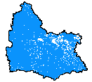
| Coal bed natural gas (CBNG) wells in the Wyoming Green River Basin |
|
| Metadata |
Scale: >=1:500,000 |
Wyoming Oil & Gas Conservation Commission |
| Shapefile |
Compressed: 80kb |
GCS North American Datum of 1983 |
Point/Decimal Degrees |
|
| SEO Wells (2008) |
 |
| This layer contains point locations of Wyoming well permit locations (clipped to the greater Green River Basin area) on file with the Wyoming State Engineer's Office (WSEO). They range in dates from December 31, 1867 to May 28, 2008. With the exception of about 50 gps points statewide, they are located only to the nearest 40 acre parcel. All locational information and attributes were imported from the Wyoming State Engineer's Office Well Permits database stored in SQL Server |
|
| Metadata |
Scale: 1:5,000,000 |
Wyoming State Engineer's Office |
| Shapefile |
Compressed: 875kb |
GCS North American Datum of 1983 |
Point/Decimal Degrees |
|
| USGS Daily Monitoring Locations (2009) |
 |
| Locations and site information on daily-measured USGS groundwater sites in the greater Green River Basin area, including stream reaches, wells, test holes, springs, tunnels, drains, lakes, reservoirs, ponds, excavations, and water-use facilities. |
|
| Metadata |
Scale: 1:5,000,000 |
Wyoming State Geological Survey |
| Shapefile |
Compressed: 8kb |
GCS North American Datum of 1983 |
Point/Decimal Degrees |
|
| USGS Manually Monitored Locations (2009) |
 |
| Locations and site information on manually-measured USGS groundwater sites in the greater Green River Basin area, including stream reaches, wells, test holes, springs, tunnels, drains, lakes, reservoirs, ponds, excavations, and water-use facilities. |
|
| Metadata |
Scale: 1:5,000,000 |
Wyoming State Geological Survey |
| Shapefile |
Compressed: 90kb |
GCS North American Datum of 1983 |
Point/Decimal Degrees |
|
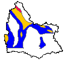
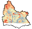
| Aquifer Group (2009) |
 |
| Major aquifer groups clipped to the greater Green River Basin area in Wyoming, and the parts of the Green River Basin in Colorado and Utah that drain into Wyoming. |
|
| Metadata |
Scale: 1:500,000 |
Wyoming State Geological Survey |
| Shapefile |
Compressed: 1,077kb |
GCS North American Datum of 1983 |
Polygon/Decimal Degrees |
|
| Aquifer Recharge (1998) |
 |
| For the following dataset, we back-calculated to get recharge (in inches/year) from the recharge rating, using the formula in the handbook (Rating = (Recharge * 6.749)^1/2 + 1). The raster dataset was then converted to polygon, and clipped to the greater Green River Basin area. For more details about this dataset, please refer to this report: Hamerlinck, J.D. and Arneson, C.S., editors, 1998, Wyoming Ground-Water Vulnerability Assessment Handbook: Volume 1. Background, Model Development, and Aquifer Sensitivity Analysis: Wyoming Geographic Information Science Center Publication WyGISC 98-01-1, University of Wyoming, Laramie, WY. |
|
| Metadata |
Scale: 1:100,000 |
Wyoming Geographic Science Center |
| Shapefile |
Compressed: 1,271kb |
GCS North American Datum of 1983 |
Polygon/Decimal Degrees |
|
| Aquifer System (2009) |
 |
| Aquifer systems clipped to the greater Green River Basin area in Wyoming, and the parts of the Green River Basin in Colorado and Utah that drain into Wyoming. |
|
| Metadata |
Scale: 1:500,000 |
Wyoming State Geological Survey |
| Shapefile |
Compressed: 1,994kb |
GCS North American Datum of 1983 |
Polygon/Decimal Degrees |
|
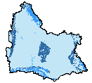
| Lakes (2008) |
 |
| This dataset contains NHD 1404 and 1405 waterbody data merged together, then clipped to the greater Green River Basin border. The National Hydrography Dataset (NHD) is a feature-based database that interconnects and uniquely identifies the stream segments or reaches that make up the nation's surface water drainage system. NHD data was originally developed at 1:100,000-scale and exists at that scale for the whole country. This high-resolution NHD, generally developed at 1:24,000/1:12,000 scale, adds detail to the original 1:100,000-scale NHD. (Data for Alaska, Puerto Rico and the Virgin Islands was developed at high-resolution, not 1:100,000 scale.) Local resolution NHD is being developed where partners and data exist. The NHD contains reach codes for networked features, flow direction, names, and centerline representations for areal water bodies. Reaches are also defined on waterbodies and the approximate shorelines of the Great Lakes, the Atlantic and Pacific Oceans and the Gulf of Mexico. The NHD also incorporates the National Spatial Data Infrastructure framework criteria established by the Federal Geographic Data Committee.
|
|
| Metadata |
Scale: 1:24,000 |
U.S. Geological Survey |
| Shapefile |
Compressed: 8,171kb |
GCS North American Datum of 1983 |
Polygon/Decimal Degrees |
|
| Precambrian Basement (2009) |
 |
| Areas deeper than 15,000 feet in the Precambrian basement of the greater Green River Basin in Wyoming |
|
| Metadata |
Scale: 1:1,000,000 |
Wyoming State Geological Survey |
| Shapefile |
Compressed: 99kb |
GCS North American Datum of 1983 |
Polygon/Decimal Degrees |
|
| Wyoming HUCs Level 4 (2002) |
 |
| This data set is a complete digital hydrologic unit boundary layer to the Subwatershed (12-digit) 6th level for the State of Wyoming.This data set consists of geo-referenced digital data and associated attributes created in accordance with the "Federal Standards For Delineation of Hydrologic Unit Boundaries 12/06/01" (http://www.ftw.nrcs.usda.gov/huc_data.html). The data set was developed by digitizing watershed boundary lines using 1:24,000 Enhanced Digital Raster Graphics (DRG-E) geo-referenced topographic image base maps and 1:100,000-scale draft boundary lines. The National Elevation Dataset (NED) was used to produce the 1:100,000-scale preliminary draft boundaries. Polygons are attributed with hydrologic unit codes for 4th level sub-basins, 5th level watersheds, 6th level subwatersheds, name, size, downsteam hydrologic unit, type of watershed, non-contributing areas and flow modification. Arcs are attributed with the highest hydrologic unit code for each watershed, linesource and a metadata reference file. Two separate shapefiles were created for downloading purposes. One with arcs (wy_hu12arc.shp) and one with polygons (wy_hu12poly.shp). The same metadata is used for both shapefiles. Only the arc attributes will be found in the wy_hu12arc shapefile. Similarly, only the poly attributes will be found in the wy_hu12poly shapefile. |
|
| Metadata |
Scale: 1:24,000 |
Wyoming Geographic Science Center |
| Shapefile |
Compressed: 2,124kb |
GCS North American Datum of 1983 |
Polygon/Decimal Degrees |
|
| Wyoming Springs (2008) |
 |
| This dataset contains locations and available attributes of springs in the greater Green River Basin in Wyoming digitized from 1:24,000 scale USGS topographic maps. |
|
| Metadata |
Scale: 1:24,000 |
Wyoming State Geological Survey |
| Shapefile |
Compressed: 37kb |
GCS North American Datum of 1983 |
Polygon/Decimal Degrees |
|
| Green River Basin Boundary (2009) |
 |
| The border for the Green River Basin Project, based on Wyoming Hydrologic Unit Boundaries to the 6th Level at 1:24,000-scale |
|
| Metadata |
Scale: 1:24,000 |
Wyoming State Geological Survey |
| Shapefile |
Compressed: 487kb |
GCS North American Datum of 1983 |
Polygon/Decimal Degrees |
|
| Rivers (1999) |
 |
| This dataset contains NHD 1404 and 1405 flowline data merged together, then clipped to the greater Green River Basin border for use in the Green River Basin Water Plan II (http://waterplan.state.wy.us). The National Hydrography Dataset (NHD) is a feature-based database that interconnects and uniquely identifies the sream segments or reaches that comprise the nation's surface water drainage system. Medium resolution NHD is based on the content of the U.S. Geological Survey 1:100,000-scale Digital Line Graph (DLG) hydrography data, integrated with reach-related information from the U.S. Environmental Protection Agency Reach File Version 3.0 (RF3). More specifically, it contains reach codes for networked features and isolated lakes, flow direction, names, stream level, and centerline representations for areal water bodies. Reaches are also defined to represent water bodies and the approximate shorelines of the Great Lakes, the Atlantic and Pacific Oceans and the Gulf of Mexico. The NHD also incorporates the National Spatial Data Infrastructure framework criteria established by the Federal Geographic Data Committee.
|
|
| Metadata |
Scale: 1:100,000 |
U.S. Geological Survey |
| Shapefile |
Compressed: 15,908kb |
GCS North American Datum of 1983 |
Polyline/Decimal Degrees |
|
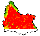
| Aquifer Sensitivity (1998) |
 |
| The following dataset has been clipped to the greater Green River Basin area for use in the Green River Basin Water Plan II (http://waterplan.state.wy.us). This dataset represents Aquifer Sensitivity to surface contamination for Wyoming at 1:100,000-scale. For further information about this layer which was produced by the Wyoming Ground Water Vulnerability Mapping. Project refer to: Hamerlinck, J.D., and Arneson, C.S., editors, 1998, Wyoming Ground Water Vulnerability Assessment Handbook: Volume 1. Background, Model Development, and Aquifer Sensitivity Analysis: Wyoming Geographic Information Science Center Publication WyGISC 98-01-1, University of Wyoming, Laramie, WY.
|
|
| Metadata |
Scale: 1:500,000 |
Wyoming Geographic Science Center |
| Shapefile |
Compressed: 1,644kb |
GCS North American Datum of 1983 |
Raster/Decimal Degrees |
|
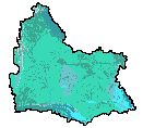
| Average Annual Precipitation (1971-2000) (2006) |
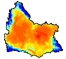 |
| This data set contains spatially gridded average monthly and annual precipitation in the greater Green River Basin for the climatological period 1971-2000. Distribution of the point measurements to a spatial grid was accomplished using the PRISM model, developed and applied by Chris Daly of OSU PRISM Group. |
|
| Metadata |
Scale: 800 meter cell |
PRSIM Group |
| Shapefile |
Compressed: 38kb |
GCS North American Datum of 1983 |
Raster/Decimal Degrees |
|
