Wyoming State Water Plan
Wyoming State Water Plan
Wyoming Water Development Office
6920 Yellowtail Rd
Cheyenne, WY 82002
Phone: 307-777-7626

Wyoming Water Development Office
6920 Yellowtail Rd
Cheyenne, WY 82002
Phone: 307-777-7626


| SUBJECT: | Green River Basin Plan Surface Water Data Collection and Study Period Selection |
| PREPARED BY: | Meg Frantz and Linda Williams, Boyle Engineering |
Introduction
Modeling the Green River Basin requires selection of an appropriate period of record for hydrologic analysis. The feasibility study (Boyle, 1998) determined that three 12-month spreadsheet models (one each representing normal-year, dry-year, and wet-year streamflows) constitute an appropriate level of detail for a modeling tool to verify existing uses and evaluate future surface water uses. Gage flows used in the three spreadsheets are to be typical of three different conditions and are to be developed by averaging observed streamflows that occurred during historical normal, wet, or dry years. Accordingly, the objectives of this task were to:
Study Period Selection
Literature Review
Several studies on the Green River basin were reviewed to determine the hydrologic study period used for each:
The study period used in this report was 1970-1992.
The study period used in this report was 1947-1991.
The study period used in this report was 1930-1982.
This brief summary indicates that a potential study period could begin thirty to fifty years ago and extend through 1998 (most current data available). A thirty to fifty year period ending in 1998 should provide sufficient variability to capture a wide range of hydrologic conditions, including wet and dry cycles.
Review of Reservoirs
Because a single annual cycle will be used to model each hydrologic condition, the normal data developed for input to the model is best derived from an operationally consistent time period. Construction or major modification of a reservoir during the study period would influence the downstream gages, hence reservoir history places significant control on selection of the study period. For this reason, major reservoirs (greater than 10,000 acre-feet) that have been constructed or modified during the past fifty years were reviewed to consider their influence on selection of the study period, with the following summarized results:
Initial screening of current basin operations suggests that the study period begin in 1971 and end in 1998. By 1971, every major existing reservoir except for Stateline was in place. A twenty-year study period (1979-1998) consistent with the post-construction period of Stateline Reservoir may be too short for a quantitative analysis. An alternative is to select 1971 through 1998 and adjust the gage below Stateline Reservoir (09220000 - East Fork of Smith Fork below Robertson) from 1971 to 1979 to reflect representative operations of Stateline Reservoir, had it existed during this time period.
Review of Streamflow Records
Analysis of available streamflow data consisted of reviewing the USGS Water-Data Report, Volume 1, Surface Water. This report lists discontinued and active surface water discharge, water quality, sediment and biological stations. This information was supplemented by a review of data reported in the SEO Annual Hydrographer's Report. Based on this review, Table 1 shows the period of record for selected gages within the Upper Green River, Blacks Fork, Henrys Fork, and Little Snake River basins. Some gage data may exist for periods prior to the period of record shown. These periods have not been listed because they are of short duration (less than 5 years continuous data) or are prior to 1930. The period of record is listed as calendar month-year. If records have been obtained from the Hydrographer's Report, only the year may be listed. Typically, flows have been recorded by the SEO for the April-September time period.
| Table 1 - USGS Gage Stations in the Green River Basin within Wyoming | |||||
|---|---|---|---|---|---|
| Station No. | Station Name | Drainage Area (mi2) | Period of Record | ||
| From | To | ||||
| Upper Green River | |||||
| 09188500 | Green River at Warren Bridge, near Daniel | 468.0 | Oct-31 Oct-93 |
Sep-92; Present | |
| 09189000 | Beaver Creek near Daniel | 141.0 | Oct-38 | Sep-54 | |
| 09189495 / SEO | North Horse Creek above Sherman Ranger Station | 42.8 | Oct-82 | Sep-84 | |
| 09189500 | Horse Creek at Sherman Ranger Station | 43.0 | Oct-54 | Sep-74 | |
| 09189550 | South Horse Creek near Merna | 33.3 | Oct-82 Apr-85 | Sep-84; Sep-85 | |
| 09190000 | Horse Creek near Daniel | 105.0 | Oct-31 Sep-82 | Oct-54; Sep-85 | |
| 09191300 / SEO | South Cottonwood Creek near Big Piney | 21.4 | Oct-82 | Sep-84 | |
| 09191500 | Cottonwood Creek near Daniel | 202.0 | Oct-38 | Sep-54 | |
| 09192750 | New Fork River above New Fork Lakes | 21.8 | Apr-85 | Sep-85 | |
| 09193000 | New Fork River below New Fork Lake, near Cora | 36.2 | Oct-38 Apr-72 |
Oct-71; Oct-72 | |
| 09196500 | Pine Creek above Fremont Lake | 75.8 | Oct-54 | Nov-97 | |
| 09197000 | Pine Creek below Fremont Lake | 114.0 | Apr-85 Apr-88 | Sep-86; Present | |
| 09198000 | Pine Creek at Pinedale | 118.0 | Oct-15 | Sep-54 | |
| 09198500 | Pole Creek below Little Half Moon Lake, near Pinedale | 87.5 | Oct-38 | Sep-71 | |
| 09199500 | Fall Creek near Pinedale | 37.2 | Oct-38 | Sep-71 | |
| 09201000 | New Fork River near Boulder | 552.0 | Oct-14 | Sep-69 | |
| 09202000 | Boulder Creek below Boulder Lake, near Boulder | 130.0 | Oct-38 May-72 |
Oct-71; Sep-73 | |
| 09203000 | East Fork River near Big Sandy | 79.2 | Oct-38 | Sep-92 | |
| 09204000 | Silver Creek near Big Sandy | 45.4 | Oct-38 | Sep-71 | |
| 09205000 | New Fork River near Big Piney | 1230.0 | e | Sep-54 | Present |
| 09205490 | N. Piney Creek above Apperson Creek, near Mason | 29.6 | Oct-82 1985 1989 |
Sep-84; 1987; Present | |
| 09205500 | North Piney Creek near Mason (Marbleton) | 58.0 | e | Oct-31 May-72 |
Oct-71; Sep-72 |
| SEO | Middle Piney Creek at Forest boundary | 1992 | Present | ||
| 09206000 | Middle Piney Creek below South Fork, near Big Piney, WY | 34.3 | Aug-39 Oct-41 |
Sep-40; Sep-54 | |
| SEO | South Piney Creek near Snider Basin | 1992 | Present | ||
| 09207700 | Dry Piney Creek near Big Piney | 67.0 | e | Oct-65 | Sep-73 |
| 0920800 | LaBarge Creek near LaBarge Meadows Ranger Station | 6.3 | e | Oct-40 Oct-50 |
Sep-42; Sep-81 |
| 09208400 | LaBarge Creek above Viola | 122.0 | Oct-82 | Sep-84 | |
| 09208500 | LaBarge Creek near Viola | 172.0 | Oct-40 | Sep-49 | |
| 09209400 | Green River near LaBarge | 3910.0 | e | Oct-63 | Present |
| 09209500 | Green River near Fontenelle | 3970.0 | Oct-46 | Mar-65 | |
| 09210500 | Fontenelle Creek near Herschler Ranch, near Fontenelle | 152.0 | Oct-51 | Present | |
| 09211000 | Fontenelle Creek near Fontenelle | 224.0 | Oct-31 | Sep-53 | |
| 09211200 | Green River below Fontenelle Reservoir | 4280.0 | Oct-63 | Present | |
| 09212500 | Big Sandy River (Creek) at Leckie Ranch near Big Sandy | 94.0 | e | Oct-39 Mar-72 |
Oct-71; Sep-87 |
| 09213500 | Big Sandy River near Farson | 322.0 | Apr-53 | Present | |
| 09214000 | Little Sandy Creek near Elkhorn | 20.9 | Oct-39 | Sep-71 | |
| 09214500 | Little Sandy Creek above Eden | 134.0 | Oct-54 | Sep-81 | |
| 09215000 | Pacific Creek near Farson | 500.0 | e | Oct-54 | Sep-73 |
| 09215550 | Big Sandy River below Farson | 1097.0 | Jun-81 | Present | |
| 09216000 | Big Sandy River (Creek) below Eden | 1610.0 | e | Oct-54 | Jun-81 |
| 09216050 | Big Sandy River at Gasson Bridge, near Eden | 1720.0 | e | May-72 | Present |
| 09216500 | Green River at Green River | 7970.0 | e | Oct-14 | Sep-39 |
| 09216545 | Bitter Creek near Bitter Creek | 308.0 | Jul-75 | Sep-81 | |
| 09216562 | Bitter Creek above Salt Wells Creek | 836.0 | Jun-76 | Sep-81 | |
| 09216565 | Salt Wells Creek near South Baxter | 34.7 | Oct-76 | Sep-81 | |
| 09216578 | Dry Canyon Creek near South Baxter | 3.7 | 1976 | 1980 | |
| 09216750 | Salt Wells Creek near Salt Wells | 526.0 | Jun-76 | Sep-81 | |
| 09217000 | Green River near Green River | 14000.0 | e | Apr-51 | Present |
| Blacks Fork | |||||
| 09217900 | Blacks Fork near Robertson | 130 | e | Jul-66 Oct-92 | Sep-86 Present |
| 09218500 | Blacks Fork near Millburne | 152 | Oct-39 | Sep 98 | |
| no winter records since Sep 92 | |||||
| 09219000 | Blacks Fork near Urie | 261 | Oct-37 | Sep-55 | |
| 09220000 | East Fork of Smith Fork near Robertson | 53 | Jul-39 | Oct 98 | |
| no winter records since Oct 71 | |||||
| 09220500 | West Fork of Smith Fork near Robertson | 37.2 | Jul-39 May-72 |
Oct-71 Sep-81 | |
| no winter records since Oct 71 | |||||
| 09221500 | Smith Fork at Mountainview | 192 | Oct-41 | Sep-57 | |
| 09222000 | Blacks Fork near Lyman | 821 | Oct-37 Jun-62 | Sep-57 Sep-83 | |
| 09222300 | Little Muddy Creek near Glencoe | 416 | Jul-76 | Sep-80 | |
| 09222400 | Muddy Creek near Hampton | 963 | Jul-75 | Sep-81 | |
| 09223000 | Hams Fork below Pole Creek near Frontier | 128 | Oct-52 | Present | |
| 09223500 | Hams Fork near Frontier | 298 | Oct-45 Apr-72 | Oct-71 Sep-72 | |
| 09224700 | Blacks Fork near Little America | 3,100 | e | Jun-62 | Present |
| 09225000 | Blacks Fork near Green River | 3,670 | e | Oct-47 | Jul-62 |
| Henrys Fork | |||||
| 09226000 | Henrys Fork near Lonetree | 56 | e | Oct-42 May-72 | Oct-71 Sep-72 |
| 09226500 | Middle Beaver Creek near Lonetree | 28 | e | Oct-48 | Sep-70 |
| 09227000 | East Fork Beaver Creek near Lonetree | 8.2 | e | Oct-48 | Sep-62 |
| 09227500 | West Fork Beaver Creek near Lonetree | 23 | e | Oct-48 | Sep-62 |
| 09228000 | Henrys Fork near Burntfork | 242 | Oct-42 | Sep-54 | |
| 09228500 | Burnt Fork near Burntfork | 52.8 | Apr-43 | Sep-83 | |
| 09229500 | Henrys Fork near Manila | 520.0 | e | Oct-28 | Sep-93 |
| Little Snake | |||||
| 09251800 | North Fork Little Snake River near Encampment | 9.64 | Oct-56 | Oct-65 | |
| 09251900 | North Fork Little Snake River near Slater, CO | 29.3 | Apr-56 | Sep-63 | |
| 09253000 | Little Snake River near Slater, CO | 285 | Oct-43 Oct-50 | Sep-47 Present | |
| 09253400 | Battle Creek near Encampment | 13 | Apr-56 Apr-85 | Sep-63 Sep-88 | |
| 09253500 | Battle Creek near Slater, CO | Oct-42 | Sep-51 | ||
| 09255000 | Slater Fork (Creek) near Slater, CO | 161 | Jul-31 | Present | |
| 09255400 | East Fork Savery Creek near Encampment | 5.57 | Apr-56 Apr-85 | Sep-58 Sep-88 | |
| 09255500 | Savery Creek at Upper Station, near Savery | 200 | Oct-40 Oct-52 | Sep-41 Sep-71 | |
| 09256000 | Savery Creek near Savery | 330 | Oct-41 Oct-47 Apr-72 Apr-85 |
Sep-46 Sep-71 Sep-72 Sep-92 | |
| 09257000 | Little Snake River near Dixon | 988 | Oct-38 May-72 | Sep 71 Sep-97 | |
| no winter records since Sep 71 | |||||
| 09258000 | Willow Creek near Dixon | 24 | e | Oct-53 | Sep-93 |
| 09259000 | Muddy Creek near Baggs | 1257 | e | Oct-87 | Sep-91 |
| 09259700 | Little Snake River near Baggs | 3020 | e | Oct 62 | Sep 68 |
| 09260000 | Little Snake River near Lily, CO | 3730 | e | Oct-21 | Present |
| WWRC | Muddy Creek at Snyder's Oil Pad | 556 | 1985 | 1985 | |
Review of Hydrologic Conditions
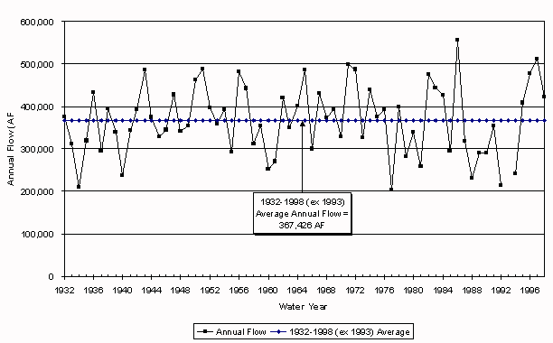
The reservoir history and availability of gage records led to a preliminary conclusion that 1971-1998 should serve as the study period. Ideally, the modeling study period should be representative of long- term hydrologic conditions in the basin. To analyze this aspect of the proposed study period, annual flows were reviewed for the USGS gage 09188500 Green River at Warren Bridge near Daniel (Figure 1). This gage has the longest record of the Green River basin gages in Wyoming, and as an indicator of long-term versus short-term statistics, is assumed applicable to the entire basin. Characteristics of the long-term (1932-1998, excluding 1993) record and the proposed study period (1971-1998, excluding 1993) are tabulated below:
| Table 2 - Characteristics of Annual Flow Series for 091885500 Green River at Warren Bridge near Daniel | ||
|---|---|---|
| 1932-1998 (excluding 1993)Record | 1971-1998 (excluding 1993) Record | |
| Mean (af) | 367,426 | 368,744 |
| Standard Deviation | 82,724 | 99,929 |
| Three highest years | 1986 / 1997 / 1971 | 1986 / 1997 / 1971 |
| Three highest values (af) | 556,150 / 513,080 / 499,510 | 556,150 / 513,080 / 499,510 |
| Three lowest years | 1977 / 1934 / 1992 | 1977 / 1992 / 1988 |
| Three lowest values (af) | 203,260 / 208,720 / 213,910 | 203,260 / 213,910 / 232,330 |
The table shows that the means of the two periods are very similar. The standard deviation for the shorter period is higher due to the smaller sample size. Most notably, the short period includes the three highest annual flows of record, as well as two of the three driest. Furthermore, Figure 1 shows that the most enduring drought of record (1987-1992) is captured in the model study period. Usually the concern is that the short period does not include extremes found in the longer record, but in this case, extremes of both wet and dry are clearly included in the proposed study period.
Figure 1. Green River at Warren Bridge, near Daniel, WY
Selected Study Period
Based on available records, existence of reservoirs, and representativeness of the period, 1971-1998 is selected as the modeling study period. This 28-year period, on average, appears similar to long-term conditions, and includes wet, dry and normal years. It would be possible to use a longer study period in the Little Snake sub-basin, but 1971-1998 will be used in this sub-basin as well, for consistency. Conversely, data may prove limiting on Henry's Fork. Gage data will have to be filled (estimated) to draw normal, wet and dry year flows from 1971-1998 on Henry's Fork. It is assumed that adequate regression relationships can be found, but if they cannot, the study period may be modified for the Henry's Fork.
In this evaluation, traditional hydrologic techniques were used to estimate missing data. Typically, this means beginning by looking for a strong linear relationship between data that overlap in time at gages with similar hydrology. The basis of success for this procedure hinges on finding similarity in runoff characteristics between two streams, then using that similarity to "rebuild" missing data values at the deficient gage for the years when no overlap exists. The strength of a linear regression relationship is described by the "coefficient of determination," or r2. This coefficient, derived mathematically through the regression exercise, is a measure of the variability in flow at one gage that can be explained by variability in the other. A perfect relationship would have an r2 = 1.0; imperfect relationships have r2 less than 1.0. Regression of hydrologic data resulting in r2 > 0.7 is often considered strong enough for data estimating, although less strong relationships may be used if no other technique is better.
Index Gage Selection
The objective of this work is to identify gages to be used to identify normal, wet and dry years by ranking of annual flows. The gages selected as representative for this purpose are termed "index" gages. Ultimately, the top (largest annual flow amounts) 20 percent of the years were designated as wet years, the middle 60 percent designated as normal years, and the 20 percent with lowest annual flows designated as dry years. The purpose of this subtask was to select gages for this ranking task that provided coverage of the basin, were relatively free of influence by man's activities, and which were relatively complete during the study period.
Approach
The periods of record for gaging stations listed in Table 1 were reviewed. Gages that were in operation during most, if not all, of the study period were selected for evaluation as index gages. Additionally, if a gage was in operation seasonally throughout the study period, it was included in the evaluation as a potential index gage. Table 3 lists the gages that met these initial screening criteria.
| Table 3 - Potential Index Gages for Hydrologic Condition | ||
|---|---|---|
| Basin | Gage No. | Gage Name |
| Upper Green River | 09188500 | Green River at Warren Bridge |
| 09196500 | Pine Creek above Fremont Lake | |
| 09205000 | New Fork River near Big Piney | |
| 09209400 | Green River near LaBarge | |
| 09210500 | Fontenelle Creek near Herschler Ranch, near Fontenelle | |
| 09211200 | Green River below Fontenelle Reservoir | |
| 09213500 | Big Sandy River near Farson | |
| 09216050 | Big Sandy River at Gasson Bridge | |
| 09217000 | Green River near Green River | |
| Blacks Fork River | 09218500 | Blacks Fork near Millburne |
| 09220000 | East Fork Smith Fork near Robertson | |
| 09223000 | Hams Fork below Pole Creek near Frontier | |
| 09224700 | Blacks Fork near Little America | |
| Henrys Fork River | 09229500 | Henrys Fork near Manila |
| Little Snake River | 09253000 | Little Snake near Slater, CO |
| 09257000 | Little Snake near Dixon | |
The above list of potential index gages was further narrowed by applying the following criteria:
This screening process resulted in eight gages remaining under consideration. Five gages required some adjustment prior to determining the wet, dry and normal years. The required adjustments are described below:
There were no USGS data available for water year 1993. Provisional data for 1993 were found in Williams thesis (1995) and in HYDRODATA, USGS Daily Values - West I, Volume 8.0 (Hydrosphere, 1996). These data were discarded because winter flows appeared excessive. A linear regression relationship was developed between the annual flow at the Green River near LaBarge gage (09209400) and the annual flow at Green River at Warren Bridge. These gages share an overlapping period of record from October 1963 through September 1998, excluding water year 1993. The relationship is:
Annual Flow at Green River at Warren Bridge  0.2198 x Annual Flow at Green River near
                                LaBarge + 106,583				   (1)
                                    r2 = 0.92
This relationship was used to estimate the annual flow at the Green River at Warren Bridge gage for 1993 prior to determining the wettest and driest 20 percent of the study years.
There are no data for water year 1998. A linear relationship was developed between the annual flow at the New Fork near Big Piney gage and the annual flow at the Pine Creek above Fremont Lake gage using regression techniques. These gages share an overlapping period of record from October 1954 through September 1997. The relationship is:
Annual Flow at Pine Creek above Fremont Lake = 0.16959 x Annual Flow at New Fork
                             near Big Piney + 37211.63				  (2)
                                  r2 = 0.91
This relationship was used to estimate the annual flow at the Pine Creek above Fremont Lake gage for 1998 prior to determining the wettest and driest 20 percent of the study years.
These two gages share an overlapping period of record from May 1972 through July 1981. A linear relationship based upon the monthly flows was determined from the overlapping data:
         Flow at Gasson Bridge = 1.0376* Flow below Eden + 722.365		  (3)
                                   r2 = 0.99
This relationship was used to synthesize monthly flow data for the period of October 1970 through April 1972 for the Big Sandy River at Gasson Bridge gage prior to determining the wettest and driest 20 percent of the study years.
Only irrigation season flow measurements exist for the 1993-1998 water years. The wettest and driest 20 percent of the study period years were determined from the irrigation season flow measurements for the study period.
It was originally assumed that the Blacks Fork near Millburne gage would be used as the Index gage for Henrys Fork. Later review of the available historical data for the Henrys Fork near Manila, Utah gage determined that there were sufficient differences between the two basins to warrant the use of this gage as an index gage for Henrys Fork.
There are no data for water years 1994-1998. A linear regression relationship was developed between the monthly flow at the Blacks Fork near Lyman gage (09222000) and the monthly flow at the Henrys Fork near Manila gage. These gages share an overlapping period of record from October 1937 through September 1957 and June 1962 through September 1983. The relationship is:
Monthly Flow at Henrys Fork near Manila = 0.5412* Monthly Flow at Blacks Fork near
                              Lyman + 561.86					(4)
                                  r2 = 0.87
Prior to extending the records for the Henrys Fork near Manila gage, the Blacks Fork near Lyman gage records had to be filled from 1994 through 1998. A linear relationship was developed between the monthly flow at the Blacks Fork near Little America gage (09224700) and the monthly flow at the Blacks Fork near Lyman gage. These gages share an overlapping period of record from June 1962 through September 1983. The relationship is:
Monthly Flow at Blacks Fork near Lyman = 0.4495* Monthly Flow at Blacks Fork near
                          Little America + 319.43				(5)
                                   r2 = 0.87
The Lyman gage record developed using Equation (5) was supplied as the independent variable in Equation (4) to synthesize monthly data for water years 1994 through 1998 for the Henrys Fork near Manila gage. Note that Equation (4) was based entirely on actual data, but applied to regressed data. Once the Manila gage record was completed through this estimation technique, the wettest and driest 20 percent of the study years were identified.
Results
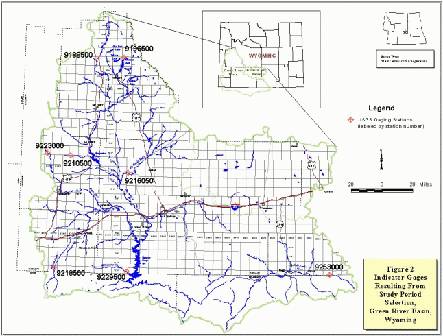
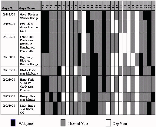
The wettest and driest 20 percent of the study period years, on an annual basis, were identified for each of the remaining gages. The index gages and corresponding wet and dry year selection are shown in Table 4. There was no exact duplication of hydrologic condition (i.e. wet and dry years did not correspond at all gages all the time), so all seven index gages will be used, applied to geographical areas as follows (see Figure 2):
Table 4 - Wet, Normal, and Dry Years for Green River Basin Index Gages
Additional Surface Water Data
As part of this task, all gage data, reservoir content data, and evaporation data required for the Green River basin model were requested from the Water Resources Data System at the University of Wyoming.
Summary
One gage (Green River at Warren Bridge) was evaluated to establish the suitability of using 1971-1998 as the modeling study period. A total of eight gaging stations (listed above) emerged as providing information suitable for determining normal, wet and dry years for the sub-basins in which they were located. Further details regarding the regression analyses and streamflow values are available in the project working papers and in the surface water modeling memorandum.
Additional References
Boyle Engineering Corp, 1998, State Water Planning Process Feasibility Report, prepared for the Wyoming Water Development Commission.