Wyoming State Water Plan
Wyoming State Water Plan
Wyoming Water Development Office
6920 Yellowtail Rd
Cheyenne, WY 82002
Phone: 307-777-7626

Wyoming Water Development Office
6920 Yellowtail Rd
Cheyenne, WY 82002
Phone: 307-777-7626


| SUBJECT: | Green River Basin Plan Major Reservoir Information |
| PREPARED BY: | Pat Tyrrell, States West Water Resources |
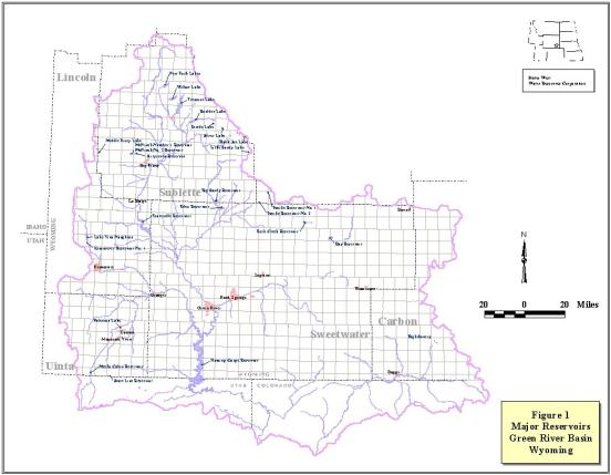
The Green River Basin contains many large reservoirs used for various purposes including storage for irrigation, municipal, industrial, recreation, fish propagation and flood control uses, among others. These reservoirs help sustain what is otherwise arid to semi-arid land. The reservoirs are owned by various state, federal, industrial and private interests. For purposes of this plan, reservoirs larger than 1,000 AF are focused upon although some that are smaller are also discussed. The list below includes reservoirs discussed in the Framework Water Plan (Wyoming Water Planning Program, 1970) and others that have been constructed, funded, or elevated in importance since. A map of these reservoirs in the Green River Basin is provided as Figure 1 at the end of this document.
In alphabetical order, the reservoirs discussed herein include:
| Water Course | Maximum Storage, AF | |
| Big Sandy River | 39,700 | |
| Black Joe Creek | 1,102 | |
| Boulder Creek | 22,280 | |
| Bush Creek | 17,267 | |
| Bush Creek | 1,686 | |
| Divide Creek | 1,027 | |
| Big & Little Sandy Rivers | 18,490* | |
| Little Sandy River | 1,450 | |
| Green River | 3,789,000 | |
| Green River | 345,397 | |
| Black Joe Creek | 1,102 | |
| Pine Creek | 30,899 | |
| Red Creek | 8,327 | |
| Savery Creek | 22,400 | |
| Hams Fork | 1,058 | |
| North Piney Creek | 1,086 | |
| North Piney Creek | 198 | |
| Blacks Fork | 33,571 | |
| West Fork New Fork River | 20,340 | |
| Blacks Fork | 1,237 | |
| Pacific Creek | 107 | |
| Pacific Creek | 1,394 | |
| Silver Creek | 933 | |
| North Piney Creek | 5,211 | |
| East Fork Smiths Fork | 14,000 | |
| Hams Fork | 42,393 | |
| Lake Creek | 18,816 |
A brief description of each follows:
| Big Sandy Reservoir | Big Sandy Reservoir Outlet |
 |
|
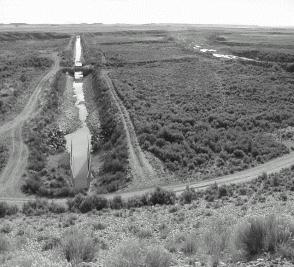
| A Bureau of Reclamation project, the Big Sandy Reservoir is formed by an earthen dam located on the Big Sandy River about 10 miles north of Farson, Wyoming. The storage capacity of 39,700 AF is permitted for irrigation use, but the reservoir also provides local recreational benefits. The reservoir is operated by the Eden Valley Irrigation and Drainage District. Additional information and data are available at http://dataweb.usbr.gov/html/eden.html on the internet [new link 10/2009 HERE]. |
Black Joe Lake
Black Joe Lake, located high in the Wind River Range in the upper reaches of the Big Sandy River, is a natural lake with its storage increased using a small dam. The dam is constructed of rock-filled timber cribbing and is approximately 13.5 feet in height. This embankment increases storage in the reservoir by 1,101.8 AF, which is permitted for irrigation. Nearby is Clear Lake, a sister lake with a similar dam, also enlarged, with a permitted capacity of 318.6 AF.
Boulder Lake
Boulder Lake, as currently configured, is a natural lake which has been raised by the addition of a dam at the outlet. With an enlargement, the reservoir now impounds over 22,000 AF above the natural lake level. The additional storage is permitted for irrigation use. Boulder Lake is a morainal lake located on the western flank of the Wind River Mountains and is, in this regard, similar to Fremont, New Fork and Willow Lakes. Boulder Lake has no staff gage or lake level instrumentation, so storage fluctuations can only be estimated. Boulder Lake irrigation releases are managed by the Boulder Irrigation District.
Bush Lake
See Hay Reservoir.
Bush Creek Reservoir
Bush Creek Reservoir is constructed to be fed by a canal from Bush Creek, located in the Great Divide Basin. On maps it is sometimes denoted John Hay Reservoir. The outlet is not tributary to the Green River. This reservoir has a permitted capacity of 17,266.651 AF designated for irrigation, stock, and domestic uses.
Divide Lake
Divide Lake is located in the Wind River Range on Divide Creek, tributary to Boulder Creek (upstream of Boulder Lake) and the New Fork River. It is an enlargement of a natural lake, with a dam constructed of a combination earthfill/rock filled cribbing structure. The dam stores a permitted capacity of 1,027.36 AF designated for irrigation, stock, and domestic uses in the Scab Creek drainage.
Eden Reservoir
Originally permitted as "Eden Irrigation and Land Company No. 1," the Eden Reservoir is an off- channel reservoir fed from the Little Sandy River and from Big Sandy Dam. Impoundment is created by three irregular dikes. Its total storage capacity, as permitted, is almost 18,500 AF, although current operations limit storage to 12,190 AF for stability reasons. Along with Big Sandy, Eden serves the Eden Valley Irrigation District. Originally planned for removal by the Bureau of Reclamation, Eden Reservoir still exists to provide irrigation water. Additional information and data are available at http://dataweb.usbr.gov/html/eden.html on the internet. [new link 10/2009 HERE]
Elkhorn
Alternately named Little Sandy Reservoir, Elkhorn Reservoir is located high on Little Sandy Creek in the southern Wind River Range. It is an enlargement of a natural lake, containing 1,450 AF permitted for stock and irrigation uses.
Flaming Gorge
Created by a concrete arch dam in Utah, Flaming Gorge is a Bureau of Reclamation Project on the main stem of the Green River. The reservoir has no Wyoming water right, and serves no lands in Wyoming, although a significant amount of its surface area is in Wyoming. The capacity of Flaming Gorge is 3,789,000 AF, which is used for irrigation, power, fish and wildlife, and recreation. More information can be found at http://dataweb.usbr.gov/dams/ut10121.htm on the internet [new link 10/2009 HERE]. Because it contains no Wyoming water rights, Flaming Gorge Reservoir is not described in the Reservoir Summary Sheets.
| Fontenelle | Fontenelle Dam |
 |
|
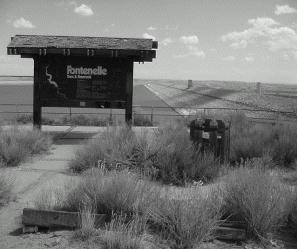
| Another Bureau of Reclamation project, Fontenelle Reservoir is an earthen dam on the main stem of the Green River, located just downstream of the town of LaBarge. With a storage capacity of 345,397 AF, Fontenelle is a multi-purpose project with permitted uses that include irrigation, domestic, industrial, municipal, stock, fisheries, recreation, and hydropower. Additional information and data are available at http://dataweb.usbr.gov/html/seedskadee.html on the internet. [new link 10/2009 HERE] |
Fremont Lake
A morainal lake, Fremont is the seventh deepest lake in the contiguous United States, excluding the Great Lakes. Like Boulder, Willow, and New Fork Lakes, its level has been raised over time by the addition of a dam at the outlet. Having been enlarged several times, Fremont Lake now impounds over 30,000 AF above the natural lake level, of which about 25,400 AF is usable (available to the newest outlet). Fremont Lake has outstanding clarity. It serves not only irrigation and recreation uses, but is also the municipal supply for the Town of Pinedale, Wyoming. Other uses listed on permits for Fremont Lake include hydropower, industrial, and fisheries. The "Fremont Lake Reservoir Operating Guide" (Gilbert, 1996) provides detailed information on the lake, its watershed characteristics, and general operating recommendations.
Hay Reservoir
The Hay Irrigation Project includes both Hay and Bush Lake Reservoirs. These reservoirs are situated about 30 miles north of I-80 nearly midway between Rawlins and Rock Springs, and are about 10 miles southeast of Bush Creek (John Hay) Reservoir. Hay Reservoir, which has been enlarged, is permitted to store approximately 5,840 AF for irrigation and stock uses. The Bush Lake Reservoir stores approximately 1,390 AF.
High Savery Reservoir
Yet to be constructed, High Savery Reservoir will provide supplemental irrigation water to the Savery Creek and Little Snake River valleys in the southeastern corner of Wyoming's Green River Basin. Located high on Savery Creek in Carbon County, High Savery will impound over 22,400 AF to provide an annual 12,000 AF yield of supplemental late-season irrigation water. As planned, High Savery will be impounded by an earthen dam. The reservoir will be owned and permitted by the State of Wyoming, and operated by the Savery - Little Snake Water Conservancy District.
Kemmerer City (Kemmerer No. 1) Reservoir
Located on the Hams Fork near the Town of Kemmerer, Wyoming, this reservoir serves as a diversion point for the town's municipal water supply. With 1,058 AF of storage, it is not large in comparison with other reservoirs in the basin.
McNinch No. 1 & 2 Reservoirs
The McNinch reservoirs are private impoundments located on McNinch Wash, tributary to North Piney Creek. They are situated about one mile west of Sixty Seven Reservoir. McNinch No. 1 is fed by Beaver Creek and Spring Creek, both tributary to North Piney Creek. McNinch No. 2 is fed by McNinch Wash (McNinch Draw). Capacities are 1,086 AF for No. 1, and 198 AF for No. 2. Both reservoirs are permitted for irrigation, stock, and domestic uses.
| Meeks Cabin Reservoir | Meeks Cabin Dam |
 |
|
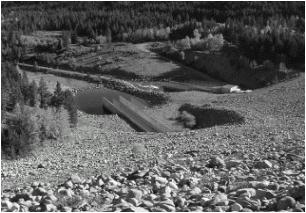
| Meeks Cabin Dam is a Bureau of Reclamation Project on the Blacks Fork (of the Green) River. Located near the Utah border, Meeks Cabin provides water for irrigation and stock from its 33,571 AF permitted capacity. The reservoir is operated by the Bridger Valley Water Conservancy District. Additional information and data are available at http://dataweb.usbr.gov/html/lyman.html on the internet. [new link 10/2009 HERE] |
Middle Piney Lake
Middle Piney Lake is located on the headwaters of Middle Piney Creek in the Bridger National Forest. It is situated about 15 miles due west of the McNinch reservoirs. The reservoir contains 4,201 AF of storage permitted for irrigation, stock ,and domestic uses. In 1997, the interest in the reservoir was assigned to the USDA Forest Service. Currently, the reservoir is operated with the outlet gates fully open, essentially passing water through the reservoir.
New Fork Lake
Among those listed here, New Fork Lake is the northernmost of the morainal lakes on the east flank of the upper Green River Basin. It is located on the upper New Fork River, a major tributary of the Green River. As with Fremont, Boulder, and Willow Lakes, its capacity has been increased by man. Currently, the lake stores 20,340 AF over and above the natural lake level. Water in this storage is permitted for irrigation use. Releases for use by the New Fork Irrigation District do not enter any single large canal near the dam. Instead, the river itself is the major conveyance, with individual irrigators taking storage water from the river at their own headgates.
Pacific Reservoirs No. 1 and 2
These two reservoirs are located on the very upper reaches of the Pacific Creek Basin, which is tributary to Little Sandy Creek, in Fremont County. Permitted capacities for the two reservoirs are 106.91 AF for No. 1 and 1,394.21 for No. 2. Interestingly, both reservoirs store water from the Sweetwater River via transbasin diversion. Both reservoirs are permitted for irrigation and stock uses.
Paterson Lake
Located about 1 mile northwest of Lyman, Paterson Reservoir is also denoted as Rollins Reservoir on some maps. It is an off-channel reservoir fed by the Fort Bridger Canal from the Blacks Fork River. The reservoir contains 1,237 AF permitted for irrigation use.
Silver Lake
Silver Lake is located in the Wind River Range on Silver Creek, tributary to the East Fork New Fork River and the New Fork River. Permitted for irrigation and stock use, the maximum capacity of the reservoir, as enlarged, is 2,151.63 AF.
Sixty-Seven
This reservoir is an off-channel structure fed by the Hughes Ditch from North Piney Creek and from Spring Creek, a tributary of North Piney Creek. As enlarged, the reservoir stores 4,329 AF for irrigation, stock, and domestic purposes. The reservoir is located about 6 miles northwest of the Town of Big Piney.
Stateline Reservoir
Stateline reservoir is located entirely within the State of Utah, and has no State of Wyoming permits. However, water within its storage capacity is used for irrigation of Wyoming lands and for municipal use in the Lyman/Fort Bridger valley. Additional information and data are available at http://dataweb.usbr.gov/html/lyman.html on the internet. [new link 10/2009 HERE]
| Viva Naughton | Viva Naughton Reservoir |
 |
|
| Viva Naughton Reservoir is operated by the Naughton Power Plant in Kemmerer. This plant (previously owned by PacifiCorp, now owned by Scottish Power) uses water from the reservoir for cooling needs of the coal-fired process. While no irrigation uses are explicitly listed in the permit, Naughton does release water for downstream irrigation during times of sufficient supply. Similarly, while Viva Naughton is not a flood control structure, the owner does try to operate the plant in a fashion to minimize downstream flooding. Constructed capacity of the reservoir is 45,465 AF. |
Willow Lake
Willow Lake is the last morainal lake on this list. This lake is located on Lake Creek, tributary to the New Fork River. Operation is not by any particular district or political entity, but by owners of "shares" in the lake's storage. Located north of Fremont Lake, the man-made storage is permitted for irrigation, stock, and domestic uses. The total permitted amount of the additional storage is 18,816 AF.
Evaporation
Evaporation from reservoirs constructed by man is a consumptive use associated with the beneficial use of water for other purposes and is charged against Wyoming's allocation under the Upper Colorado River Basin Compact. Traditionally, evaporation estimates are calculated by the Bureau of Reclamation and published in the "Consumptive Uses and Losses Report," (CULR) which is prepared every five years. In this report, the larger Bureau reservoirs in the Green and Colorado River Basins are classified as "main stem" reservoirs, the evaporation from which is tabulated and carried separately from evaporation calculated for in-state reservoirs. Upper Colorado River Basin main stem reservoirs include Flaming Gorge, Blue Mesa, Morrow Point and Lake Powell.
For these main stem reservoirs, the aggregate evaporation is charged against the various states' apportionment in the percentage allowed for each state by the Upper Colorado River Basin Compact, under full development (full use of allowed depletions). By this Compact Wyoming is allowed 14 percent of the total depletions allowed the States of the Upper Division (the Upper Basin States minus Arizona) by the Colorado River Compact; therefore, at full development, 14 percent of the Upper Basin mainstem evaporation is charged to Wyoming. Prior to full development, Article V of the Upper Colorado River Basin Compact states that Wyoming's share will be calculated as the same fraction of main stem evaporation as Wyoming's consumptive use bears to the total consumptive use by States of the Upper Division.
For the years 1986-1990, Wyoming's fraction of the total consumptive use of the Upper Division states was 13.55 percent. In these same years, the average main stem evaporation was 653,000 acre-feet. Therefore, Wyoming's charge for main stem evaporation would be calculated as 88,482 acre-feet. This value, however, overstates the amount of Wyoming's main stem evaporation portion when the basin sees full development. Under full development of all states' full compact allotments, reservoir levels will average lower than they do now, due to increased drawdowns. Under this scenario the Bureau estimates a full development main stem evaporation of 520,000 acre-feet annually, from which Wyoming's 14 percent charge can be estimated to be 72,800 acre-feet annually (Bureau of Reclamation, January 1999).
Reservoirs not included in the main stem calculations are handled separately and the evaporation therefrom is charged totally to the state within which they reside. In Wyoming, the Bureau has identified 76 individual reservoirs in the Green River Basin for which evaporation is explicitly calculated. Table 1 lists these reservoirs and the net annual evaporation at each for the years 1986-1990, which is the last full five year period for which a final CULR is available. The Bureau charges evaporation without regard to the uses for which a reservoir is permitted. That is, no separate accounting is kept for evaporation from irrigation, recreation, fish and wildlife or other pools.
In Table 1, Bureau evaporation values have been altered for New Fork, Boulder, Willow and Fremont Lakes. In the CULR supporting documentation for these lakes, all of which originally were natural lakes raised by dams added at their outlets, the evaporation calculated uses the full high water line areas in the calculation. Because only that depletion caused by the actions of man should be counted against the Compact allocation, these estimates have been revised to reflect only the incremental evaporation loss due to the incremental surface area increase caused by raising the lakes. To do this, evaporation was calculated for the increase in high water line surface area, not for the lake as a whole. These changes result in a net savings in evaporation of approximately 4,082 acre-feet, as described below:
| Reservoir | Natural HWL Surface Area, ac | Enlarged HWL Surface Area, ac | Difference, ac | Net Evaporation, from CULR, in. | Actual Evaporation due to Man, AF | CULR Evap, as reported, AF | Difference, AF (savings) |
|---|---|---|---|---|---|---|---|
| Boulder | 1540 | 1676 | 136 | 22.3 | 253 | 1872 | 1619 |
| Fremont | 4888 | 5122 | 234 | 20 | 390 | 0 | -390 |
| New Fork | 1296 | 1416 | 120 | 19 | 190 | 1345 | 1155 |
| Willow | 1800 | 1958 | 158 | 20 | 263 | 1961 | 1698 |
| Total |
| 1096 | 5178 | 4082 |
Two sources of data exist for estimating evaporative losses from reservoirs in Wyoming. These include the National Weather Service (Farnsworth et al, June 1982) and Lewis (1978). Because it is newer, of national scope, and used by the Bureau of Reclamation in its Consumptive Uses and Losses Report calculations, the NWS document is used for annual gross (free water surface) evaporation values herein. However, the NWS document does not give a monthly distribution of evaporation rates. For this, the distribution pattern for Pathfinder Dam (Lewis, 1978) is used.
The net evaporation rate at a reservoir, or the true amount lost after correction for rainfall, is calculated as gross evaporation minus average precipitation by month. Data describing gross evaporation and precipitation on an average monthly basis are provided as part of Appendix A. The source of precipitation data for use in estimating net evaporation is Daly and Taylor (1998).
| Table 1 - Wyoming Reservoir Evaporation | ||||||
| Reservoir | Net Annual Evaporation (acre-feet)1 | |||||
|---|---|---|---|---|---|---|
| 1986 | 1987 | 1988 | 1989 | 1990 | Average | |
| BEAVERS | 38.1 | 38.1 | 38.1 | 38.1 | 38.1 | 38.1 |
| BIG SANDY | 5569.8 | 5308.2 | 3602.3 | 2224.6 | 3774.1 | 4095.8 |
| BLACK JOE LAKE | 113.1 | 113.1 | 113.1 | 113.1 | 113.1 | 113.1 |
| BOULDER LAKE2 | 253.0 | 253.0 | 253.0 | 253.0 | 253.0 | 253.0 |
| BOULTER | 44.1 | 44.1 | 44.1 | 44.1 | 44.1 | 44.1 |
| BROADBENT NO.2 | 19.3 | 19.3 | 19.3 | 19.3 | 19.3 | 19.3 |
| BYRNE | 16.1 | 16.1 | 16.1 | 16.1 | 16.1 | 16.1 |
| BYRNE | 26.4 | 26.4 | 26.4 | 26.4 | 26.4 | 26.4 |
| CLEAR LAKE | 48.3 | 48.3 | 48.3 | 48.3 | 48.3 | 48.3 |
| CLIFFORD F. GRAHAM | 77.2 | 77.2 | 77.2 | 77.2 | 77.2 | 77.2 |
| COLLETI NO.2 | 7.6 | 7.6 | 7.6 | 7.6 | 7.6 | 7.6 |
| COTTONWOOD | 93.3 | 93.3 | 93.3 | 93.3 | 93.3 | 93.3 |
| COW CREEK (1987) | 0.0 | 0.0 | 135.7 | 135.7 | 135.7 | 81.4 |
| COYOTE | 18.4 | 18.4 | 18.4 | 18.4 | 18.4 | 18.4 |
| DAVIS NO.1 | 22.0 | 22.0 | 22.0 | 22.0 | 22.0 | 22.0 |
| DAVIS NO.2 | 31.5 | 31.5 | 31.5 | 31.5 | 31.5 | 31.5 |
| DIVIDE LAKE | 133.0 | 133.0 | 133.0 | 133.0 | 133.0 | 133.0 |
| EDEN | 1930.4 | 1861.0 | 1429.7 | 974.6 | 1343.9 | 1507.9 |
| ELIAS | 8.9 | 8.9 | 8.9 | 8.9 | 8.9 | 8.9 |
| ELKHORN (LITTLE SANDY) | 145.0 | 145.0 | 145.0 | 145.0 | 145.0 | 145.0 |
| ENLARGEMENT OF THE NO.3 | 464.2 | 464.2 | 464.2 | 464.2 | 464.2 | 464.2 |
| ERICKSON | 27.3 | 27.3 | 27.3 | 27.3 | 27.3 | 27.3 |
| ERRAMOUSPE | 32.5 | 32.5 | 32.5 | 32.5 | 32.5 | 32.5 |
| FIFTEEN MILL KNOLL | 55.0 | 55.0 | 55.0 | 55.0 | 55.0 | 55.0 |
| FONTENELLE | 7518.7 | 5573.5 | 5245.6 | 14415.1 | 15139.9 | 9578.5 |
| FOSDICK | 26.1 | 26.1 | 26.1 | 26.1 | 26.1 | 26.1 |
| FRANKLIN | 43.3 | 46.1 | 46.2 | 46.2 | 46.2 | 45.6 |
| FREMONT LAKE2 | 390.0 | 390.0 | 390.0 | 390.0 | 390.0 | 390.0 |
| GRAHAM | 30.9 | 33.3 | 34.7 | 34.7 | 34.7 | 33.6 |
| GRAHAM NO.2 | 30.0 | 30.0 | 30.0 | 30.0 | 30.0 | 30.0 |
| GUILD | 46.6 | 46.6 | 46.6 | 46.6 | 46.6 | 46.6 |
| GUILD & DEAN | 102.5 | 102.5 | 102.5 | 102.5 | 102.5 | 102.5 |
| HICKEY | 8.0 | 8.0 | 8.0 | 8.0 | 8.0 | 8.0 |
| HIGHLINE | 60.4 | 60.4 | 60.4 | 60.4 | 60.4 | 60.4 |
| ISOM (AUSTIN) | 369.8 | 369.8 | 369.8 | 369.8 | 369.8 | 369.8 |
| J.O. | 16.3 | 16.3 | 16.3 | 16.3 | 16.3 | 16.3 |
| J-J NO.3 | 8.4 | 8.4 | 8.4 | 8.4 | 8.4 | 8.4 |
| JOE BUDD | 22.4 | 22.4 | 22.4 | 22.4 | 22.4 | 22.4 |
| KEMMERER | 216.2 | 216.2 | 216.2 | 216.2 | 216.2 | 216.2 |
| KITCHEN | 17.8 | 17.8 | 17.8 | 17.8 | 17.8 | 17.8 |
| KOVACH (1988) | 0.0 | 0.0 | 0.0 | 54.7 | 54.7 | 21.9 |
| LAKE VIVA NAUGHTON | 2699.4 | 2699.4 | 2699.4 | 2699.4 | 2699.4 | 2699.4 |
| LITTLE ROBBER | 48.7 | 48.7 | 48.7 | 48.7 | 48.7 | 48.7 |
| LOWER SNAKE DRAW RESERVOIR | 1776.3 | 1776.3 | 1776.3 | 1776.3 | 1776.3 | 1776.3 |
| MCNINCH NO.1 | 133.5 | 133.5 | 133.5 | 133.5 | 133.5 | 133.5 |
| MCNINCH NO.2 | 53.7 | 53.7 | 53.7 | 53.7 | 53.7 | 53.7 |
| MEEKS CABIN | 695.1 | 641.3 | 526.8 | 468.8 | 461.2 | 558.6 |
| MIDDLE PINEY | 227.5 | 227.5 | 227.5 | 227.5 | 227.5 | 227.5 |
| MOSLANDER | 27.5 | 27.5 | 27.5 | 27.5 | 27.5 | 27.5 |
| NEW FORK LAKE2 | 190.0 | 190.0 | 190.0 | 190.0 | 190.0 | 190.0 |
| PACIFIC NO.1 | 29.2 | 29.2 | 29.2 | 29.2 | 29.2 | 29.2 |
| PACIFIC NO.2 (HAY MEADOW) | 309.3 | 309.3 | 309.3 | 309.3 | 309.3 | 309.3 |
| PATTERSON LAKE (ROLLINS) | 291.1 | 309.5 | 320.2 | 320.2 | 320.2 | 312.2 |
| PHILIP | 6.7 | 7.1 | 7.4 | 7.4 | 7.4 | 7.2 |
| PIEDMONT | 62.1 | 62.1 | 62.1 | 62.1 | 62.1 | 62.1 |
| POWERS STOCK | 58.4 | 58.4 | 58.4 | 58.4 | 58.4 | 58.4 |
| PROSPECT NO.1 | 59.5 | 59.5 | 59.5 | 59.5 | 59.5 | 59.5 |
| REED | 136.3 | 145.9 | 146.2 | 146.2 | 146.2 | 144.2 |
| SHEEP MOUNTAIN | 45.5 | 45.5 | 45.5 | 45.5 | 45.5 | 45.5 |
| SILVER LAKE | 162.0 | 162.0 | 162.0 | 162.0 | 162.0 | 162.0 |
| SIXTY SEVEN | 467.1 | 467.1 | 467.1 | 467.1 | 467.1 | 467.1 |
| SKULL POINT | 6.3 | 6.3 | 6.3 | 6.3 | 6.3 | 6.3 |
| SODA LAKE WETLANDS (1989) | 0.0 | 0.0 | 0.0 | 0.0 | 25.2 | 5.0 |
| SPHAERALCEA | 17.4 | 17.4 | 17.4 | 17.4 | 17.4 | 17.4 |
| STOFFER RIDGE | 23.4 | 23.4 | 23.4 | 23.4 | 23.4 | 23.4 |
| SUBLETTE (JUEL) | 68.8 | 68.8 | 68.8 | 68.8 | 68.8 | 68.8 |
| SUNSET | 13.7 | 13.7 | 13.7 | 13.7 | 13.7 | 13.7 |
| TIPPERARY (MURRAY) | 30.3 | 30.3 | 30.3 | 30.3 | 30.3 | 30.3 |
| UNCAPHER | 56.6 | 56.6 | 56.6 | 56.6 | 56.6 | 56.6 |
| VACHER (VANTASSEL) | 4.4 | 4.4 | 4.4 | 4.4 | 4.4 | 4.4 |
| WALL DEVELOPMENT COMPANY DAM | 158.8 | 169.1 | 169.5 | 169.5 | 169.5 | 167.2 |
| WARD BALL | 61.9 | 61.9 | 61.9 | 61.9 | 61.9 | 61.9 |
| WASATCH (RINGDAHL) | 21.3 | 21.3 | 21.3 | 21.3 | 21.3 | 21.3 |
| WILLIAMS NO.2 | 20.0 | 20.0 | 20.0 | 20.0 | 20.0 | 20.0 |
| WILLIAMS NO.3 | 26.3 | 26.3 | 26.3 | 26.3 | 26.3 | 26.3 |
| WILLOW LAKE2 | 263.0 | 263.0 | 263.0 | 263.0 | 263.0 | 263.0 |
| ZEMBA | 19.5 | 19.5 | 19.5 | 19.5 | 19.5 | 19.5 |
| Green River Basin CULR Total | 26,362 | 24,066 | 21,635 | 28,969 | 31,630 | 26,530 |
| Other Reservoirs Not in CULR: | Average Annual Estimates of Net evaporation: | |||||
|---|---|---|---|---|---|---|
| HIGH SAVERY | 869.0 | |||||
| MUDDY CREEK WETLANDS | 284.0 | |||||
| Grand Total | 27,683 | |||||
Attachments
Attached to this memo is more information regarding the reservoirs listed above. Table 2, Green River Basin Reservoir Summary lists all of the reservoirs along with location, permit information, owner, etc. Following this table is Appendix A, where each reservoir is detailed on a Reservoir Summary Sheet, listing, in addition to most of the information from Table 1, summaries of the outlet works and spillway construction and capacities, monthly evaporation and precipitation rates, and operating notes. When available, the end-of-month contents are also listed. Following the summary sheet, area-capacity tables are presented for reservoirs if they could be obtained. The sources for the information contained in these attachments are the permits on file at the Wyoming State Engineer's Office and in the list of references to follow.
| Table 2 - Green River Basin Reservoir Summary | |||||||||||
| Reservoir or Lake | Watercourse | County | S,T(N),R(W) | Permit No. | Priority Date | Permitted Uses | HWL Area (Ac) | HWL Capacity (AF) | Reservoir Owner/Manager | Year of Cert. of Const. | Notes |
|---|---|---|---|---|---|---|---|---|---|---|---|
| Big Sandy | Big Sandy River | Sweetwater | 11,26,106 | 947R | 11/09/1906 | I | 1,660.8 | 39,700 | Eden Valley Irr Dist & USBR | 1983 | |
| Black Joe | Black Joe Creek | Sublette | 17,32,103 | 5397R | 03/21/1935 | I | 102.49 | 1,108.8 | USA, c/o Farm Security Adm. | 1945 | |
| Boulder | Boulder Creek | Sublette | 14,33,108 | 4038R | 01/27/1927 | I | 1,698 | 16,207 | Boulder Irr. Dist | 1956 | |
| 6572R | 04/26/1961 | I, D, Ind, M, S, FI, R | 1,676.5 | 6,073 | 1970 | 4,453 AF Irr, 1,621 AF FI & W | |||||
| Bush Creek | Bush Creek | Sweetwater | 15,25,98 | 4058R | 02/24/1928 | I, S, D | 2,629.243 | 17,266.651 | Blair and Hay Land and Livestock Company | 1959 | Reservoir has 2 dams: Outlet No.1 in Sec.15, Outlet No. 2 in Sec.14 |
| Divide | Divide Creek | Sublette | 14,33,106 | 5365R | 07/30/1934 | I, S, D | 133.28 | 1,028.36 | Mr. John Blatt | 1967 | Releases used in Scab Cr. Drainage |
| Eden | Big & Little Sandy Rivers | Sweetwater | 20,26,105 | 818R | 12/30/1905 | I, D | 1,361.85 | 18,489.93 | Eden Irrigation & Land Co. | 1925 | off-channel storage |
| Elkhorn (Little Sandy) | Little Sandy Creek | Sublette | 27,31,103 | 1025R | 07/23/1906 | I | 145 | 1,450 | Joe Thompson Jr. Livestock Co. | 1947 | Also known as Little Sandy |
| Flaming Gorge | Green River | Sweetwater | 22,12,108 | Utah | Dam is in UT | ||||||
| Fontenelle | Green River | Lincoln | 25,24,112 | 6629R | 01/22/1962 | I, D, Ind, M, S, H, FI, R | 8,058 | 345,397 | USBR | 1992 | |
| 9502R | 12/07/1973 | I, D, Ind, M, S, H, FI, R | No Change | No Change | Enlargement activated prev. inactive cap. | ||||||
| Fremont | Pine Creek | Sublette | 23,24,109 | 4452R | 09/10/1931 | I, M, H, Man, FI, Ind, R | 5,067.96 | 9,844.12 | Town of Pinedale | 1962 | Total Cap = 30,899.44 AF |
| 4453R | 09/15/1931 | I, S, D | 5,087.02 | 5,377.92 | L. H. Hennick et al | ||||||
| 4465R | 11/29/1951 | I, S, D | 5,105.72 | 5,385.4 | Fremont Lake Res. Assn. | 1956 | |||||
| 8937R | 02/02/1977 | I, M | 5,122.28 | 10,292.00 | Town of Pinedale & Highland Irrigation District | 1997 | |||||
| Hay | Red Creek | Sweetwater | 33,24,97 | 547R | 07/20/1904 | I, S | 310 | 2,480 | Sweetwater Cattle Company | 1930 | Total Capacity = 5,846.59 AF |
| 2339R | 08/11/1911 | I, S | 1,036.63 | 3,366.59 | 1917 | ||||||
| High Savery | Savery Creek | Carbon | 16,15,88 | NA | I | 482 | 22,433 | State of Wyoming | NA | Under Construction | |
| Kemmerer No.1 | Ham's Fork | Lincoln | 26,23,117 | 5302R | 05/24/1935 | Ind, M | 134.27 | 1,058 | City of Kemmerer | 1958 | Total Capacity = 1,768.78 AF |
| 9776R | 01/12/1990 | Ind, M | 182.93 | 710.78 | 1990 | ||||||
| McNinch No.1 | Spring Creek | Sublette | 11,30,113 | 5413R | 03/05/1941 | I, S, D | 108.2 | 873 | E.W. McNinch and Lois C. McNinch | 1956 | Total Capacity = 1086.35 AF |
| 5801R | 07/17/1947 | I, S, D | 107.04 | 213.35 | 1956 | ||||||
| McNinch No.2 | McNinch Draw | Sublette | 11,30,113 | 5412R | 03/05/1941 | I, S, D | 26.4 | 198 | E.W. McNinch and Lois C. McNinch | 1957 | |
| Meeks Cabin | Blacks Fork | Uinta | 11,12,117 | 6276R | 03/26/1935 | I, S | 326 | 16,301.5 | USBR | 1979 | Total Capacity = 33,571 AF: Enl Transfer from Willow Cr Res. |
| 5547R | 04/06/1939 | 765 | 17,269.5 | ||||||||
| Middle Piney | Middle Piney Creek | Sublette | 8,30,115 | 3578R | 07/04/1919 | I, S, D | 164.56 | 4,201 | USDA Forest Service | 1944 | |
| New Fork Lake | W Fk New Fork River | Sublette | 7,36,109 | 480R | 11/11/1903 | I | 1,416 | 20,340 | 1951 | ||
| Pacific No.1 | Pacific Creek | Fremont | 1,27,102 | 4025R | 08/14/1926 | I, S | 23.27 | 106.91 | 1926 | Source is Sweetwater River (transbasin) | |
| Pacific No.2 | Whitehorse Creek | Fremont | 32,27,102 | 4026R | 08/14/1926 | I, S | 257.88 | 1394.24 | 1926 | Source is Whitehorse Draw and Sweetwater River | |
| Patterson Lake | Black's Fork River | Uinta | 19,16,114 | 443R | 08/12/1903 | I, D, H | 200 | 1,237 | Farmer's Land and Livestock Co. | 1955 | |
| Silver Lake | Silver Creek | Sublette | 34,33,105 | 3970R | 11/19/1924 | I | 157.52 | 1,219.11 | Silver Lake Reservoir Company | 1948 | Total Cap = 2,151.63 AF |
| 5769R | 11/20/1950 | I, S | 180.0 | 932.52 | Silver Lake Irrigation District | ||||||
| Sixty Seven | North Piney Creek | Sublette | 17,30,112 | 535R | 07/08/1904 | S, D | 293.568 | 3,373.732 | Mr. Jay Downes | 1935 | Total Cap = 4329 AF |
| 2878R | 07/12/1915 | S, D | 333 | 953.268 | 1935 | ||||||
| State Line | E. Fk. Smiths Fk | in Utah | USBR | dam and res in UT; UT permits not shown | |||||||
| Viva Naughton | Ham's Fork | Lincoln | 14,23,117 | 6418R | 08/01/1957 | Ind | 1,458.18 | 42.393 | UP&L | 1977 | |
| 7476R | 08/20/1971 | Ind, I | 1,935.65 | 27,252 | assigned to Pacificorp | NA | 3,072 AF of 7476R Built; Total Cap. = 45,465 AF. | ||||
| 7599R | 08/20/1973 | Ind | 2,200 | 12,250 | |||||||
| Willow | Lake Creek (Trib. Willow Cr.) | Sublette | 19,35,109 | 3831R | 03/24/1922 | I, S, D | 1,945 | 15,120 | Burleigh Binning | 1931 | Total Cap = 22,630 AF |
| 4475R | 11/04/1931 | I, S, D | 1,856 | 3,696 | 1949 | ||||||
| 6257R | I, S, D | 1,958 | 3,814 | 1962 | |||||||
References
Daly, Chris and George Taylor, April 1998, "Wyoming Average Monthly or Annual Precipitation, 1961-1990," Water and Climate Center of the Natural Resources Conservation Service.
Farnsworth, Richard K., Edwin S. Thompson and Eugene L. Peck, June 1982, Evaporation Atlas for the Contiguous 48 United States, NOAA Technical Report NWS 33, Office of Hydrology, National Weather Service, Washington D.C.
Gilbert, Ted, 1996, "Fremont Lake Reservoir Operating Guide," prepared for the Highland Irrigation District and the Town of Pinedale, Wyoming.
Lewis, Larry Eugene, 1978, "Development of an Evaporation Map for the State of Wyoming for Purposes of Estimating Evaporation and Evapotranspiration," Masters Thesis, University of Wyoming.
United States Department of the Interior, Bureau of Reclamation, September 1998, "Colorado River System Consumptive Uses and Losses Report, 1986-1990."
United States Department of the Interior, Bureau of Reclamation, January 1999, "Quality of Water, Colorado River Basin," Progress Report No. 19.
Williams, Linda I., December 1995, "A Model of the Green River Using the Wyoming Integrated River System Operation Study (WIRSOS)," M.S. Thesis, University of Wyoming, Department of Civil Engineering.
Wyoming Water Planning Program, September 1970, "Water and Related Land Resources of the Green River Basin, Wyoming: Wyoming Water Planning Program Report No. 3," Wyoming State Engineer's Office.
Appendix A
Reservoir Name: Big Sandy
Owner/Operator: Eden Valley Irr. Dist and U.S. Bureau of Reclamation
Storage Permit Nos: 947R
HWL Data: Area, ac: 1,660.80 Cap, ac-ft: 39,700 Elev, ft ms 6,760
Permitted Uses: Water Right Owners:
Use: Irr 39,700 ac-ft Eden Valley Irr Dist
ac-ft
ac-ft
ac-ft
ac-ft
Service Outlet: Type: 5'6" dia. Horseshoe cor Capacity, cfs 650
Principal Spillway: Type: Capacity, cfs
Emergency Spillway: Type: weir Capacity, cfs 7,600
Miscellaneous Spillway Info:
Average Annual Gross FWS Evaporation (in.): 40.00
Average Monthly Gross Evaporation (in.):
Oct 3.04 Feb 1.00 Jun 5.24
Nov 1.56 Mar 1.56 Jul 6.84
Dec 1.04 Apr 3.20 Aug 6.24
Jan 1.08 May 4.60 Sep 4.60 Total, in: 40.00
Average Monthly Precipitation (in.):
Oct 0.68 Feb 0.34 Jun 1.01
Nov 0.40 Mar 0.52 Jul 0.88
Dec 0.41 Apr 0.63 Aug 0.71
Jan 0.37 May 1.16 Sep 0.90 Total, in: 8.01
Average EOM Contents (ac-ft):
Oct 13,500 Feb 13,400 Jun 30,000
Nov 15,000 Mar 19,700 Jul 26,800
Dec 9,500 Apr 22,300 Aug 18,400
Jan 12,100 May 23,400 Sep 13,100
Operating Notes: Eden Valley Irrigation and Drainage District operates the Big Sandy
Reservoir. The reservoir is operated to provide water to the district members on a
call basis, through a canal system. The canals include the Means and Eden Canals, the
Eden and West Side Laterals, and the Farson Lateral. Recent construction of regulating
reservoirs for pump stations has decreased delivery delays to farmers, which used to
be significant, and helped with application efficiency. EOM data developed from USBR
Consumptive Uses and Losses Report, 1986-1990.
Reservoir Name: Black Joe Lake
Owner/Operator: USA, c/o Farm Security Adm.
Storage Permit Nos: 5397R
HWL Data: Area, ac: 102.5 Cap, ac-ft: 1,102 Elev, ft ms 9,944
Permitted Uses: Water Right Owners:
Use: Irr 1,102 ac-ft 5397R Farm Security Adm.
ac-ft
ac-ft
ac-ft
ac-ft
Service Outlet: Type: Gated Outlet Capacity, cfs NR
Principal Spillway: Type: Weir Capacity, cfs NR
Emergency Spillway: Type: Capacity, cfs
Miscellaneous Spillway Info:
Average Annual Gross FWS Evaporation (in.): 36.17
Average Monthly Gross Evaporation (in.):
Oct 2.75 Feb 0.90 Jun 4.74
Nov 1.41 Mar 1.41 Jul 6.19
Dec 0.94 Apr 2.89 Aug 5.64
Jan 0.98 May 4.16 Sep 4.16 Total, in: 36.17
Average Monthly Precipitation (in.):
Oct 2.25 Feb 3.25 Jun 1.95
Nov 4.00 Mar 3.00 Jul 1.80
Dec 4.25 Apr 2.85 Aug 1.75
Jan 4.25 May 2.85 Sep 1.95 Total, in: 34.15
Average EOM Contents (ac-ft):
Oct N/A Feb N/A Jun N/A
Nov N/A Mar N/A Jul N/A
Dec N/A Apr N/A Aug N/A
Jan N/A May N/A Sep N/A
Operating Notes:
No operating data are available
Reservoir Name: Boulder Lake
Owner/Operator: Boulder Irrigation District
Storage Permit Nos: 4038R 6572R
HWL Data: Area, ac: 1,676.5 Cap, ac-ft: 22,208 Elev, ft ms 7289.5
Permitted Uses: Water Right Owners:
Use: Irr 16,207 ac-ft 4038R
Irr 4,453 ac-ft 6572R
Fish & WL 1,621 ac-ft 6572R
ac-ft
ac-ft
Service Outlet: Type: 2 - 4.5 ft x 4.5 ft RCP Capacity, cfs 900
Principal Spillway: Type: concrete weir Capacity, cfs 6,160
Emergency Spillway: Type: Capacity, cfs
Miscellaneous Spillway Info: Maps show location of emergency spillway, but
give no details.
Average Annual Gross FWS Evaporation (in.): 35.34
Average Monthly Gross Evaporation (in.):
Oct 2.69 Feb 0.88 Jun 4.63
Nov 1.38 Mar 1.38 Jul 6.04
Dec 0.92 Apr 2.83 Aug 5.51
Jan 0.95 May 4.06 Sep 4.06 Total, in: 35.34
Average Monthly Precipitation (in.):
Oct 0.95 Feb 0.97 Jun 1.35
Nov 1.27 Mar 0.98 Jul 1.30
Dec 1.25 Apr 1.06 Aug 1.25
Jan 1.38 May 1.85 Sep 1.42 Total, in: 15.03
Average EOM Contents (ac-ft):
Oct N/A Feb N/A Jun N/A
Nov N/A Mar N/A Jul N/A
Dec N/A Apr N/A Aug N/A
Jan N/A May N/A Sep N/A
Operating Notes: Irrigation releases are typically in the range of 360 cfs from May
15 to July 15. Releases occur at the dam and are picked up at the Boulder Irrigation
Canal approximately 2 miles below the dam. Fall operations include a diversion of 100
to 125 cfs in September to increase soil moisture before winter. Approximately 35 cfs
is diverted in October for stock water. The Howard-Ruth ditch is directly below the
dam and annually purchases storage water from the lake.
Boulder Reservoir has no staff gage, and no storage records are kept.
Reservoir Name: Bush Creek Reservoir
Owner/Operator: Blair and Hay Land and Livestock Company
Storage Permit Nos: 4058R
HWL Data: Area, ac: 2,629.2 Cap, ac-ft: 17,267 Elev, ft msl:
Permitted Uses: Water Right Owners:
Use: Irr, Stock, Dom 17,267 ac-ft 4058R, Blair and Hay Land & Livestock
ac-ft
ac-ft
ac-ft
ac-ft
Service Outlet: Type: 2x30"Dia. Gated Condui Capacity, cfs NR
Principal Spillway: Type: Weir Capacity, cfs NR
Emergency Spillway: Type: Capacity, cfs
Miscellaneous Spillway Info:
Note: Reservoir contains 2 dams, each dam containing it's own outlet.
Average Annual Gross FWS Evaporation (in.): 40.00
Average Monthly Gross Evaporation (in.):
Oct 3.04 Feb 1.00 Jun 5.24
Nov 1.56 Mar 1.56 Jul 6.84
Dec 1.04 Apr 3.20 Aug 6.24
Jan 1.08 May 4.60 Sep 4.60 Total, in: 40.00
Average Monthly Precipitation (in.):
Oct 0.94 Feb 0.46 Jun 1.05
Nov 0.50 Mar 0.70 Jul 0.99
Dec 0.47 Apr 0.95 Aug 0.89
Jan 0.46 May 1.45 Sep 0.99 Total, in: 9.85
Average EOM Contents (ac-ft):
Oct N/A Feb N/A Jun N/A
Nov N/A Mar N/A Jul N/A
Dec N/A Apr N/A Aug N/A
Jan N/A May N/A Sep N/A
Operating Notes:
No reservoir operating data were obtained; impoundment is in the Great
Divide Basin.
Reservoir Name: Divide
Owner/Operator: Mr. John Blatt
Storage Permit Nos: 5365R
HWL Data: Area, ac: 133.3 Cap, ac-ft: 1,027 Elev, ft msl:
Permitted Uses: Water Right Owners:
Use: Irr, Stock, Dom 1,027 ac-ft 5365R, T.J. Land & Cattle
ac-ft
ac-ft
ac-ft
ac-ft
Service Outlet: Type: Gated 24" Corr. Iron Pipe Capacity, cfs NR
Principal Spillway: Type: Weir Capacity, cfs NR
Emergency Spillway: Type: Capacity, cfs
Miscellaneous Spillway Info:
Average Annual Gross FWS Evaporation (in.): 35.00
Average Monthly Gross Evaporation (in.):
Oct 2.66 Feb 0.88 Jun 4.59
Nov 1.37 Mar 1.37 Jul 5.99
Dec 0.91 Apr 2.80 Aug 5.46
Jan 0.95 May 4.03 Sep 4.03 Total, in: 35.00
Average Monthly Precipitation (in.):
Oct 1.80 Feb 2.75 Jun 1.70
Nov 3.45 Mar 2.45 Jul 1.55
Dec 3.70 Apr 2.12 Aug 1.35
Jan 4.06 May 2.20 Sep 1.75 Total, in: 28.88
Average EOM Contents (ac-ft):
Oct N/A Feb N/A Jun N/A
Nov N/A Mar N/A Jul N/A
Dec N/A Apr N/A Aug N/A
Jan N/A May N/A Sep N/A
Operating Notes:
No reservoir operating data were obtained. Releases are made into the Scab
Creek drainage.
Reservoir Name: Eden
Owner/Operator: U.S. Bureau of Reclamation / Eden Valley Irr. Dist
Storage Permit Nos: 818R
HWL Data: Area, ac: 1,361.85 Cap, ac-ft: 18,489.93 Elev, ft ms 6,710
Permitted Uses: Water Right Owners:
Use: Irr, Dom 18,489.93 ac-ft 818R Eden Valley Irr Dist
ac-ft
ac-ft
ac-ft
ac-ft
Service Outlet: Type: gated 5'x6' tunnel Capacity, cfs NR
Principal Spillway: Type: Capacity, cfs
Emergency Spillway: Type: NA Capacity, cfs
Miscellaneous Spillway Info: NR = not rated. There is no emergency spillway
because this is an off-channel structure.
Average Annual Gross FWS Evaporation (in.): 40.00
Average Monthly Gross Evaporation (in.):
Oct 3.04 Feb 1.00 Jun 5.24
Nov 1.56 Mar 1.56 Jul 6.84
Dec 1.04 Apr 3.20 Aug 6.24
Jan 1.08 May 4.60 Sep 4.60 Total, in: 40.00
Average Monthly Precipitation (in.):
Oct 0.68 Feb 0.34 Jun 1.01
Nov 0.40 Mar 0.52 Jul 0.88
Dec 0.41 Apr 0.63 Aug 0.71
Jan 0.37 May 1.16 Sep 0.90 Total, in: 8.01
Average EOM Contents (ac-ft):
Oct 400 Feb 1,400 Jun 5,000
Nov 600 Mar 1,800 Jul 3,700
Dec 1,000 Apr 2,600 Aug 1,100
Jan 1,200 May 5,200 Sep 800
Operating Notes: Eden Reservoir is operated by the Eden Valley Irrigation and
Drainage District. It is operated to compliment the operation of Big Sandy Reservoir.
Average EOM content data developed from USBR Consumptive Uses and Losses Report,
1986-1990.
Reservoir Name: Elk Horn (Little Sandy)
Owner/Operator: Joe Thompson Jr. Livestock Co.
Storage Permit Nos: 1025R
HWL Data: Area, ac: 145.0 Cap, ac-ft: 1,450 Elev, ft msl:
Permitted Uses: Water Right Owners:
Use: Irrigation 1,450 ac-ft 1025R, Joe Thompson Jr. Livestock Co.
ac-ft
ac-ft
ac-ft
ac-ft
Service Outlet: Type: 2' x 4' conduit Capacity, cfs NR
Principal Spillway: Type: Weir Capacity, cfs NR
Emergency Spillway: Type: Capacity, cfs
Miscellaneous Spillway Info:
Average Annual Gross FWS Evaporation (in.): 35.00
Average Monthly Gross Evaporation (in.):
Oct 2.66 Feb 0.88 Jun 4.59
Nov 1.37 Mar 1.37 Jul 5.99
Dec 0.91 Apr 2.80 Aug 5.46
Jan 0.95 May 4.03 Sep 4.03 Total, in: 35.00
Average Monthly Precipitation (in.):
Oct 1.88 Feb 2.85 Jun 1.75
Nov 3.55 Mar 2.50 Jul 1.55
Dec 3.70 Apr 2.30 Aug 1.45
Jan 4.08 May 2.40 Sep 1.85 Total, in: 29.86
Average EOM Contents (ac-ft):
Oct N/A Feb N/A Jun N/A
Nov N/A Mar N/A Jul N/A
Dec N/A Apr N/A Aug N/A
Jan N/A May N/A Sep N/A
Operating Notes:
Reservoir Name: Fontenelle
Owner/Operator: U.S. Bureau of Reclamation
Storage Permit Nos: 6629R 9502R
HWL Data: Area, ac: 8,058 Cap, ac-ft: 345,397 Elev, ft msl: 6,506
Permitted Uses: Water Right Owners:
Use: various 345,397 ac-ft U.S. Bureau of Reclamation
ac-ft
ac-ft
ac-ft
ac-ft
Service Outlet: Type: 11 ft dia. conduit Capacity, cfs 19,000
Principal Spillway: Type: east - 2 -4'x4'conduits Capacity, cfs NR
Principal Spillway: Type: west - 2 -4'x6'conduits Capacity, cfs 20,000
Emergency Spillway: Type: weir Capacity, cfs 20,500
Miscellaneous Spillway Info: NR = not rated.
Average Annual Gross FWS Evaporation (in.): 41.33
Average Monthly Gross Evaporation (in.):
Oct 3.14 Feb 1.03 Jun 5.41
Nov 1.61 Mar 1.61 Jul 7.07
Dec 1.07 Apr 3.31 Aug 6.45
Jan 1.12 May 4.75 Sep 4.75 Total, in: 41.33
Average Monthly Precipitation (in.):
Oct 0.59 Feb 0.26 Jun 0.95
Nov 0.35 Mar 0.36 Jul 0.73
Dec 0.27 Apr 0.65 Aug 0.63
Jan 0.23 May 1.07 Sep 0.91 Total, in: 7.00
Average EOM Contents (ac-ft):
Oct 237,876 Feb 153,123 Jun 261,477
Nov 225,472 Mar 141,568 Jul 274,370
Dec 202,975 Apr 140,839 Aug 262,723
Jan 177,489 May 175,654 Sep 251,799
Operating Notes: Fontenelle is generally operated to maximize storage, power
generation and flood mitigation. It also is used to maintain the aquatic and riparian
habitat at Seedskadee Wildlife Refuge. Releases are typically 1,200 to 1,400 cfs from
August to April. During spring runoff, releases are increased to maintain reservoir
pool elevation increases to 1 to 2 feet daily. The maximum elevation target is 6,506
feet, or 345,000 AF in storage. The operator (Bureau) endeavors to keep release peaks
below inflow peaks, which average about 11,000 cfs. After spring runoff ceases and
peak storage is met, releases are again set back to 1,200 to 1,400 cfs.
Reservoir Name: Fremont Lake
Owner/Operator:
Storage Permit Nos: 4452R 4453R
4465R 8937R
HWL Data: Area, ac: 5,400 Cap, ac-ft: 30,899.44 Elev, ft msl:7,411.45
Permitted Uses: Water Right Owners:
Use: ac-ft
ac-ft
ac-ft
ac-ft
ac-ft
Service Outlet: Type: gated Capacity, cfs NR
Principal Spillway: Type: weir/flashboards Capacity, cfs NR
Emergency Spillway: Type: Capacity, cfs NR
Miscellaneous Spillway Info: Entire dam and control works act as the service
and emergency spillway. Both the Highland and Fremont Ditch headgates are
built directly into the face of the dam.
Average Annual Gross FWS Evaporation (in.): 35.90
Average Monthly Gross Evaporation (in.):
Oct 2.73 Feb 0.90 Jun 4.70
Nov 1.40 Mar 1.40 Jul 6.14
Dec 0.93 Apr 2.87 Aug 5.60
Jan 0.97 May 4.13 Sep 4.13 Total, in: 35.90
Average Monthly Precipitation (in.):
Oct 0.95 Feb 1.00 Jun 1.35
Nov 1.20 Mar 0.98 Jul 1.30
Dec 1.20 Apr 1.10 Aug 1.30
Jan 1.38 May 1.85 Sep 1.38 Total, in: 14.99
Average EOM Contents (ac-ft):
Oct N/A Feb N/A Jun N/A
Nov N/A Mar N/A Jul N/A
Dec N/A Apr N/A Aug N/A
Jan N/A May N/A Sep N/A
Operating Notes: Highland Irrigation District is the operator of the dam. Operating
procedures are as follows: Beginning Nov. 1 each year, inflow bypasses are adjusted
in an effort to satisfy storage rights while maintaining a reasonable fishery in
Pine Creek below the dam. During spring runoff, inlows will be used to meet storage
rights as well as downstream irrigation rights. Otherwise, endeavor to operate the
reservoir such that all rights, even those not signatory to the operating procedures,
are not adversely affected in times of water shortage. Discharges from the reservoir
can be taken directly into the Highland and Fremont Irrigation Canals or returned to
Pine Creek.
Reservoir Name: Hay
Owner/Operator: Sweetwater Cattle Company
Storage Permit Nos: 547R 2339R
HWL Data: Area, ac: 1,036.6 Cap, ac-ft: 5,847 Elev, ft msl:
Permitted Uses: Water Right Owners:
Use: Irr, Stock 2,480 ac-ft 547R, Sweetwater Cattle Company
Irr, Stock 3,363 ac-ft 2339R, Sweetwater Cattle Company
ac-ft
ac-ft
ac-ft
Service Outlet: Type: 2'3"x2'0" Conc. Culvert Capacity, cfs NR
Principal Spillway: Type: Weir Capacity, cfs NR
Emergency Spillway: Type: Capacity, cfs
Miscellaneous Spillway Info:
Average Annual Gross FWS Evaporation (in.): 44.50
Average Monthly Gross Evaporation (in.):
Oct 3.38 Feb 1.11 Jun 5.83
Nov 1.74 Mar 1.74 Jul 7.61
Dec 1.16 Apr 3.56 Aug 6.94
Jan 1.20 May 5.12 Sep 5.12 Total, in: 44.50
Average Monthly Precipitation (in.):
Oct 0.85 Feb 0.40 Jun 0.95
Nov 0.45 Mar 0.46 Jul 0.97
Dec 0.42 Apr 0.93 Aug 0.87
Jan 0.40 May 1.25 Sep 0.94 Total, in: 8.89
Average EOM Contents (ac-ft):
Oct N/A Feb N/A Jun N/A
Nov N/A Mar N/A Jul N/A
Dec N/A Apr N/A Aug N/A
Jan N/A May N/A Sep N/A
Operating Notes:
Reservoir Name: High Savery
Owner/Operator: State of Wyoming (under construction)
Storage Permit Nos:
HWL Data: Area, ac: 482.3 Cap, ac-ft: 22,432.90 Elev, ft msl: 7,305
Permitted Uses: Water Right Owners:
Use: Inactive 47.7 ac-ft State of Wyoming
active-rec 4,955 ac-ft
irr 17,430.20 ac-ft
flood pool 10,932.30 ac-ft
ac-ft
Service Outlet: Type: 48 inch conduit Capacity, cfs 397
Principal Spillway: Type: concret chute Capacity, cfs 9,586
Emergency Spillway: Type: earthen - excavated Capacity, cfs 41,110
Miscellaneous Spillway Info:
Average Annual Gross FWS Evaporation (in.): 45.10
Average Monthly Gross Evaporation (in.):
Oct 3.7 Feb 1 Jun 5.9
Nov 1.6 Mar 1.8 Jul 7.7
Dec 1.2 Apr 3.9 Aug 6.7
Jan 1.2 May 5.3 Sep 5.1 Total, in: 45.10
Average Monthly Precipitation (in.):
Oct 1.60 Feb 0.80 Jun 1.40
Nov 1.00 Mar 1.20 Jul 1.30
Dec 1.20 Apr 1.40 Aug 1.40
Jan 1.10 May 1.40 Sep 1.30 Total, in: 15.10
Average EOM Contents (ac-ft):
Oct N/A Feb N/A Jun N/A
Nov N/A Mar N/A Jul N/A
Dec N/A Apr N/A Aug N/A
Jan N/A May N/A Sep N/A
Operating Notes: High Savery dam is currently under construction, with completion
scheduled for spring of 2004. The reservoir will primarily serve agriculture with a
12,000 AF yield of late season irrigation water from a 17,430.2 AF irrigation pool.
Irrigation water would be allocated by the Savery - Little Snake Water Conservancy
District. The reservoir also includes a recreation pool of 4,955 AF. EIS operation
studies indicate annual average evaporation of 869 AF and annual depletions of 6,855
AF, for total annual depletions of 7,724 AF. Source of Precip and Evap data: WWC
Temperature Study, 1988.
Reservoir Name: Kemmerer No. 1
Owner/Operator: City of Kemmerer
Storage Permit Nos: 5302R 9776R
HWL Data: Area, ac: 182.93 Cap, ac-ft: 1,768.78 Elev, ft msl:7,145.90
Permitted Uses: Water Right Owners:
Use: M&I 1,025.00 ac-ft 5302R
M&I 710.78 ac-ft 9776R
inactive ac-ft
ac-ft
ac-ft
Service Outlet: Type: 2-36" CMP w/ 28" line Capacity, cfs 185
Principal Spillway: Type: weir Capacity, cfs 1,120
Emergency Spillway: Type: weir Capacity, cfs 27,000
Miscellaneous Spillway Info: Emergency spillway capacity includes principal
spillway. Liners inside service pipes are HDPE.
Average Annual Gross FWS Evaporation (in.): 38.63
Average Monthly Gross Evaporation (in.):
Oct 2.94 Feb 0.97 Jun 5.06
Nov 1.51 Mar 1.51 Jul 6.61
Dec 1.00 Apr 3.09 Aug 6.03
Jan 1.04 May 4.44 Sep 4.44 Total, in: 38.63
Average Monthly Precipitation (in.):
Oct 0.84 Feb 0.65 Jun 1.15
Nov 0.87 Mar 0.73 Jul 0.82
Dec 0.75 Apr 0.96 Aug 0.91
Jan 0.69 May 1.22 Sep 1.19 Total, in: 10.78
Average EOM Contents (ac-ft):
Oct N/A Feb N/A Jun N/A
Nov N/A Mar N/A Jul N/A
Dec N/A Apr N/A Aug N/A
Jan N/A May N/A Sep N/A
Operating Notes: This reservoir serves the City of Kemmerer. The reservoir itself
used to be the point of diversion for the city treatment plant; however operational
changes are such that the city now diverts from the Hams Fork River downstream of the
reservoir. There are no special operating criteria for this reservoir, it is
typically operated as a flow-through structure with little, if any, changes made to
the gate settings.
Reservoir Name: McNinch No. 1
Owner/Operator: E.W McNinch and Lois C. McNinch
Storage Permit Nos: 5413R 5801R
HWL Data: Area, ac: 107.0 Cap, ac-ft: 1,086 Elev, ft msl:
Permitted Uses: Water Right Owners:
Use: Irr,Stock,Dom 1,086 ac-ft 5801R, E.W. & Lois C. McNinch
ac-ft
ac-ft
ac-ft
ac-ft
Service Outlet: Type: Gated 18" CMP Capacity, cfs NR
Principal Spillway: Type: Weir Capacity, cfs 548
Emergency Spillway: Type: Capacity, cfs
Miscellaneous Spillway Info:
Average Annual Gross FWS Evaporation (in.): 38.95
Average Monthly Gross Evaporation (in.):
Oct 2.96 Feb 0.97 Jun 5.10
Nov 1.52 Mar 1.52 Jul 6.66
Dec 1.01 Apr 3.12 Aug 6.08
Jan 1.05 May 4.48 Sep 4.48 Total, in: 38.95
Average Monthly Precipitation (in.):
Oct 0.58 Feb 0.47 Jun 1.01
Nov 0.60 Mar 0.55 Jul 0.89
Dec 0.52 Apr 0.69 Aug 0.89
Jan 0.52 May 1.17 Sep 0.97 Total, in: 8.86
Average EOM Contents (ac-ft):
Oct N/A Feb N/A Jun N/A
Nov N/A Mar N/A Jul N/A
Dec N/A Apr N/A Aug N/A
Jan N/A May N/A Sep N/A
Operating Notes: The McNinch Reservoirs are private storage reservoirs the operation
of which is at the whim of the owner. Sources of supply are the numerous springs and
draws tributary to North Piney Creek as outlined in the Tabulation of Adjudicated
Water Rights.
Reservoir Name: McNinch No. 2
Owner/Operator: E.W. McNinch and Lois C. McNinch
Storage Permit Nos: 5412R
HWL Data: Area, ac: 26.4 Cap, ac-ft: 198 Elev, ft msl:
Permitted Uses: Water Right Owners:
Use: Irr,Stock,Dom 198 ac-ft 5412R, E.W. & Lois C. McNinch
ac-ft
ac-ft
ac-ft
ac-ft
Service Outlet: Type: 18" Cast Iron Pipe Capacity, cfs NR
Principal Spillway: Type: Weir Capacity, cfs NR
Emergency Spillway: Type: Capacity, cfs
Miscellaneous Spillway Info:
Average Annual Gross FWS Evaporation (in.): 38.96
Average Monthly Gross Evaporation (in.):
Oct 2.96 Feb 0.97 Jun 5.10
Nov 1.52 Mar 1.52 Jul 6.66
Dec 1.01 Apr 3.12 Aug 6.08
Jan 1.05 May 4.48 Sep 4.48 Total, in: 38.96
Average Monthly Precipitation (in.):
Oct 0.58 Feb 0.47 Jun 1.01
Nov 0.60 Mar 0.55 Jul 0.89
Dec 0.52 Apr 0.69 Aug 0.89
Jan 0.52 May 1.17 Sep 0.97 Total, in: 8.86
Average EOM Contents (ac-ft):
Oct N/A Feb N/A Jun N/A
Nov N/A Mar N/A Jul N/A
Dec N/A Apr N/A Aug N/A
Jan N/A May N/A Sep N/A
Operating Notes: The McNinch Reservoirs are private storage reservoirs the operation
of which is at the whim of the owner. Sources of supply are the numerous springs and
draws tributary to North Piney Creek as outlined in the Tabulation of Adjudicated
Water Rights.
Reservoir Name: Meeks Cabin
Owner/Operator: U.S. Bureau of Reclamation/Bridger Valley Water CD
Storage Permit Nos: 6276R 5547R
HWL Data: Area, ac: 326.6 Cap, ac-ft: 16,301.50 Elev, ft msl:8,740.0
Permitted Uses: Water Right Owners:
Use: Irr 16,301.50 ac-ft 6276R, U.S. Bureau of Reclamation
Irr,Stock,Power 17,269.50 ac-ft 5574R, U.S. Bureau of Reclamation
ac-ft
ac-ft
ac-ft
Service Outlet: Type: Capacity, cfs
Principal Spillway: Type: Capacity, cfs
Emergency Spillway: Type: concrete lined channel Capacity, cfs
Miscellaneous Spillway Info:
Average Annual Gross FWS Evaporation (in.): 35.00
Average Monthly Gross Evaporation (in.):
Oct 2.66 Feb 0.88 Jun 4.59
Nov 1.37 Mar 1.37 Jul 5.99
Dec 0.91 Apr 2.80 Aug 5.46
Jan 0.95 May 4.03 Sep 4.03 Total, in: 35.00
Average Monthly Precipitation (in.):
Oct 2.25 Feb 1.85 Jun 1.85
Nov 1.85 Mar 2.80 Jul 1.50
Dec 1.78 Apr 2.85 Aug 1.75
Jan 1.85 May 2.75 Sep 1.75 Total, in: 24.83
Average EOM Contents (ac-ft):
Oct 8,950 Feb 10,700 Jun >16,300
Nov 9,270 Mar 11,290 Jul >16,300
Dec 9,760 Apr 18,070 Aug 12,550
Jan 10,170 May >16,300 Sep 9,950
Operating Notes: Meeks Cabin Reservoir is operated by the Bridger Valley Water
Conservancy District on a call basis. District members are provided water upon
demand, usually after their requirements cannot be met from direct flow water rights
due to recession of runoff. Typically, about 30 percent of the annual reservoir
demand is used prior to the hay cutting (July 24, in a typical year), with the
remainder used in the fall to fill the soil profile. Meeks Cabin Reservoir has a 10
cfs minimum by-pass amount.
Reservoir Name: Middle Piney
Owner/Operator: USDA Forest Service
Storage Permit Nos: 3578R
HWL Data: Area, ac: 164.6 Cap, ac-ft: 4,201 Elev, ft msl:
Permitted Uses: Water Right Owners:
Use: Irr,Stock,Dom 4,201 ac-ft 3578R, USDA Forest Service
ac-ft
ac-ft
ac-ft
ac-ft
Service Outlet: Type: Gated 24" and 42" CMP Capacity, cfs NR
Principal Spillway: Type: Weir Capacity, cfs 603
Emergency Spillway: Type: Capacity, cfs
Miscellaneous Spillway Info:
Average Annual Gross FWS Evaporation (in.): 37.75
Average Monthly Gross Evaporation (in.):
Oct 2.87 Feb 0.94 Jun 4.95
Nov 1.47 Mar 1.47 Jul 6.46
Dec 0.98 Apr 3.02 Aug 5.89
Jan 1.02 May 4.34 Sep 4.34 Total, in: 37.75
Average Monthly Precipitation (in.):
Oct 2.30 Feb 5.00 Jun 1.85
Nov 5.75 Mar 4.00 Jul 1.50
Dec 6.25 Apr 2.82 Aug 1.55
Jan 6.75 May 3.25 Sep 1.80 Total, in: 42.82
Average EOM Contents (ac-ft):
Oct N/A Feb N/A Jun N/A
Nov N/A Mar N/A Jul N/A
Dec N/A Apr N/A Aug N/A
Jan N/A May N/A Sep N/A
Operating Notes: Middle Piney Reservoir has recently (1997) had its agricultural
water rights abandoned and all interest in the reservoir has been assigned to the
U.S. Forest Service. The State Engineer's Office reports that operation of the
reservoir is essentially unmanaged, and that the discharge gates are simply left wide
open.
Reservoir Name: New Fork Lake
Owner/Operator:
Storage Permit Nos: 480R
HWL Data: Area, ac: 1,416 Cap, ac-ft: 20,340 Elev, ft msl: 7,819
Permitted Uses: Water Right Owners:
Use: Irr 1,416 ac-ft New Fork Lake Irrigation District
ac-ft
ac-ft
ac-ft
ac-ft
Service Outlet: Type: 3 gated concrete conduits Capacity, cfs 838
Principal Spillway: Type: Capacity, cfs
Emergency Spillway: Type: weir Capacity, cfs 2,260
Miscellaneous Spillway Info:
Average Annual Gross FWS Evaporation (in.): 35.00
Average Monthly Gross Evaporation (in.):
Oct 2.66 Feb 0.88 Jun 4.59
Nov 1.37 Mar 1.37 Jul 5.99
Dec 0.91 Apr 2.80 Aug 5.46
Jan 0.95 May 4.03 Sep 4.03 Total, in: 35.00
Average Monthly Precipitation (in.):
Oct 1.45 Feb 2.38 Jun 1.45
Nov 2.85 Mar 2.00 Jul 1.45
Dec 3.25 Apr 1.85 Aug 1.35
Jan 3.45 May 1.95 Sep 1.48 Total, in: 24.91
Average EOM Contents (ac-ft):
Oct N/A Feb N/A Jun N/A
Nov N/A Mar N/A Jul N/A
Dec N/A Apr N/A Aug N/A
Jan N/A May N/A Sep N/A
Operating Notes: New Fork Lake is owned and operated by the New Fork Lake Irrigation
District. It is operated primarily as an irrigation storge reservoir. Runoff is
stored in the reservoir until elevation 38.0 is exceeded, at which point water will
begin to flow through the spillway. Release of water through the outlet is dependent
on manual operation of three (3) slide gates, and is governed by irrigation needs and
adjudicated water rights. There is no major District canal or ditch which is fed by
the reservoir; the New Fork River itself is the primary conveyance with individual
irrigators diverting directly therefrom.
Reservoir Name: Pacific Reservoir No. 1
Owner/Operator:
Storage Permit Nos: 4025R
HWL Data: Area, ac: 23.27 Cap, ac-ft: 106.91 Elev, ft msl:7220+/-
Permitted Uses: Water Right Owners:
Use: Irr,Stock 106.91 ac-ft
ac-ft
ac-ft
ac-ft
ac-ft
Service Outlet: Type: Capacity, cfs
Principal Spillway: Type: Capacity, cfs
Emergency Spillway: Type: Capacity, cfs
Miscellaneous Spillway Info:
Average Annual Gross FWS Evaporation (in.): 35.00
Average Monthly Gross Evaporation (in.):
Oct 2.66 Feb 0.88 Jun 4.59
Nov 1.37 Mar 1.37 Jul 5.99
Dec 0.91 Apr 2.80 Aug 5.46
Jan 0.95 May 4.03 Sep 4.03 Total, in: 35.00
Average Monthly Precipitation (in.):
Oct 0.75 Feb 0.70 Jun 1.50
Nov 0.75 Mar 1.00 Jul 1.00
Dec 0.75 Apr 1.25 Aug 0.75
Jan 0.75 May 1.30 Sep 1.00 Total, in: 11.50
Average EOM Contents (ac-ft):
Oct N/A Feb N/A Jun N/A
Nov N/A Mar N/A Jul N/A
Dec N/A Apr N/A Aug N/A
Jan N/A May N/A Sep N/A
Operating Notes:
Reservoir Name: Pacific Reservoir No. 2
Owner/Operator:
Storage Permit Nos: 4026R
HWL Data: Area, ac: 257.88 Cap, ac-ft: 1,394.21 Elev, ft msl:7010+/-
Permitted Uses: Water Right Owners:
Use: Irr,Stock 106.91 ac-ft
ac-ft
ac-ft
ac-ft
ac-ft
Service Outlet: Type: Capacity, cfs
Principal Spillway: Type: Capacity, cfs
Emergency Spillway: Type: Capacity, cfs
Miscellaneous Spillway Info:
Average Annual Gross FWS Evaporation (in.): 38.00
Average Monthly Gross Evaporation (in.):
Oct 2.89 Feb 0.95 Jun 4.98
Nov 1.48 Mar 1.48 Jul 6.50
Dec 0.99 Apr 3.04 Aug 5.93
Jan 1.03 May 4.37 Sep 4.37 Total, in: 38.00
Average Monthly Precipitation (in.):
Oct 0.60 Feb 0.55 Jun 1.30
Nov 0.60 Mar 0.80 Jul 0.90
Dec 0.60 Apr 1.00 Aug 0.60
Jan 0.60 May 1.20 Sep 0.90 Total, in: 9.65
Average EOM Contents (ac-ft):
Oct N/A Feb N/A Jun N/A
Nov N/A Mar N/A Jul N/A
Dec N/A Apr N/A Aug N/A
Jan N/A May N/A Sep N/A
Operating Notes:
Reservoir Name: Paterson Lake
Owner/Operator: Farmer's Land and Livestock Company
Storage Permit Nos: 433R
HWL Data: Area, ac: 200.0 Cap, ac-ft: 1,874 Elev, ft msl:
Permitted Uses: Water Right Owners:
Use: Irr,Dom,Power 1,874 ac-ft 433R, Farmer's Land & Livestock Co.
ac-ft
ac-ft
ac-ft
ac-ft
Service Outlet: Type: Capacity, cfs
Principal Spillway: Type: Capacity, cfs
Emergency Spillway: Type: Capacity, cfs
Miscellaneous Spillway Info:
Average Annual Gross FWS Evaporation (in.): 41.02
Average Monthly Gross Evaporation (in.):
Oct 3.12 Feb 1.03 Jun 5.37
Nov 1.60 Mar 1.60 Jul 7.01
Dec 1.07 Apr 3.28 Aug 6.40
Jan 1.11 May 4.72 Sep 4.72 Total, in: 41.02
Average Monthly Precipitation (in.):
Oct 0.83 Feb 0.31 Jun 1.11
Nov 0.48 Mar 0.52 Jul 0.90
Dec 0.44 Apr 0.86 Aug 0.89
Jan 0.36 May 1.15 Sep 0.95 Total, in: 8.80
Average EOM Contents (ac-ft):
Oct N/A Feb N/A Jun N/A
Nov N/A Mar N/A Jul N/A
Dec N/A Apr N/A Aug N/A
Jan N/A May N/A Sep N/A
Operating Notes:
Reservoir Name: Silver Lake
Owner/Operator: Silver Lake Reservoir Company
Storage Permit Nos: 3790R 5769R
HWL Data: Area, ac: 180.0 Cap, ac-ft: 2,152 Elev, ft msl:
Permitted Uses: Water Right Owners:
Use: Irrigation 1,219 ac-ft 3790R, Silver Lake Reservoir Co.
Irr, Stock 933 ac-ft 5769R, Silver Lake Irrigation Co.
ac-ft
ac-ft
ac-ft
Service Outlet: Type: Gated 30" CMP Capacity, cfs NR
Principal Spillway: Type: Weir Capacity, cfs 784
Emergency Spillway: Type: Capacity, cfs
Miscellaneous Spillway Info:
Average Annual Gross FWS Evaporation (in.): 35.00
Average Monthly Gross Evaporation (in.):
Oct 2.66 Feb 0.88 Jun 4.59
Nov 1.37 Mar 1.37 Jul 5.99
Dec 0.91 Apr 2.80 Aug 5.46
Jan 0.95 May 4.03 Sep 4.03 Total, in: 35.00
Average Monthly Precipitation (in.):
Oct 1.85 Feb 3.10 Jun 1.75
Nov 3.70 Mar 2.50 Jul 1.65
Dec 4.10 Apr 2.25 Aug 1.40
Jan 4.30 May 2.30 Sep 1.75 Total, in: 30.65
Average EOM Contents (ac-ft):
Oct N/A Feb N/A Jun N/A
Nov N/A Mar N/A Jul N/A
Dec N/A Apr N/A Aug N/A
Jan N/A May N/A Sep N/A
Operating Notes:
Reservoir Name: Sixty Seven
Owner/Operator: Mr. Jay Downes
Storage Permit Nos: 535R 2878R
HWL Data: Area, ac: 333.0 Cap, ac-ft: 4,329 Elev, ft msl:
Permitted Uses: Water Right Owners:
Use: Stock,Dom 3,376 ac-ft 535R, Perry W. Jenkins
Stock,Dom 953 ac-ft 2878R, Perry W. Jenkins
ac-ft
ac-ft
ac-ft
Service Outlet: Type: 2 x 16" CIP Capacity, cfs NR
Principal Spillway: Type: Weir Capacity, cfs NR
Emergency Spillway: Type: Capacity, cfs
Miscellaneous Spillway Info:
Average Annual Gross FWS Evaporation (in.): 39.18
Average Monthly Gross Evaporation (in.):
Oct 2.98 Feb 0.98 Jun 5.13
Nov 1.53 Mar 1.53 Jul 6.70
Dec 1.02 Apr 3.13 Aug 6.11
Jan 1.06 May 4.51 Sep 4.51 Total, in: 39.18
Average Monthly Precipitation (in.):
Oct 0.58 Feb 0.47 Jun 1.01
Nov 0.60 Mar 0.55 Jul 0.89
Dec 0.52 Apr 0.69 Aug 0.89
Jan 0.52 May 1.17 Sep 0.97 Total, in: 8.86
Average EOM Contents (ac-ft):
Oct N/A Feb N/A Jun N/A
Nov N/A Mar N/A Jul N/A
Dec N/A Apr N/A Aug N/A
Jan N/A May N/A Sep N/A
Operating Notes: Sixty Seven is a privately owned reservoir the operation of which
is at the whim of the owner.
Reservoir Name: State Line
Owner/Operator: U.S. Bureau of Reclamation/Bridger Valley Water CD
Storage Permit Nos: Utah Permit
HWL Data: Area, ac: Cap, ac-ft: Elev, ft msl:
Permitted Uses: Water Right Owners:
Use: ac-ft
ac-ft
ac-ft
ac-ft
ac-ft
Service Outlet: Type: Capacity, cfs
Principal Spillway: Type: Capacity, cfs
Emergency Spillway: Type: Capacity, cfs
Miscellaneous Spillway Info:
Average Annual Gross FWS Evaporation (in.): 34.00
Average Monthly Gross Evaporation (in.):
Oct 2.58 Feb 0.85 Jun 4.45
Nov 1.33 Mar 1.33 Jul 5.81
Dec 0.88 Apr 2.72 Aug 5.30
Jan 0.92 May 3.91 Sep 3.91 Total, in: 34.00
Average Monthly Precipitation (in.):
Oct Feb Jun
Nov Mar Jul
Dec Apr Aug
Jan May Sep Total, in: 0.00
Average EOM Contents (ac-ft):
Oct N/A Feb N/A Jun N/A
Nov N/A Mar N/A Jul N/A
Dec N/A Apr N/A Aug N/A
Jan N/A May N/A Sep N/A
Operating Notes: State Line Reservoir is operated by the Bridger Valley Water
Conservancy District on a call basis. District members are provided water upon
demand, usually after their requirements cannot be met from direct flow water rights
due to recession of runoff. Typically, about 30 percent of the annual reservoir
demand is used prior to the hay cutting (July 24, in a typical year), with the
remainder used in the fall to fill the soil profile. In addition, municipal supplies
are provided from June through September each year by agreement between the District
and the Lyman-Fort Bridger Joint Powers Board. The State Line Reservoir has a 7-cfs
minimum by-pass amount.
Reservoir Name: Viva Naughton
Owner/Operator: Naughton Power Plant (Scottish Power)
Storage Permit Nos: 6418R 7476R* * 3,072 AF Constructed
7599R** ** = not constructed
HWL Data: Area, ac: 1458.18 Cap, ac-ft: 45,465 Elev, ft msl:7240
Permitted Uses: Water Right Owners:
Use: Ind, 6418R 42,393 ac-ft assigned to Pacificorp
Ind, 7476R 3,072 ac-ft
ac-ft
ac-ft
ac-ft
Service Outlet: Type: 2 hydropower penstock Capacity, cfs840 (740+100)
Principal Spillway: Type: 2 slide gates Capacity, cfs12,000 total
Emergency Spillway: Type: fuse plug Capacity, cfs
Miscellaneous Spillway Info:
Average Annual Gross FWS Evaporation (in.): 38.54
Average Monthly Gross Evaporation (in.):
Oct 2.93 Feb 0.96 Jun 5.05
Nov 1.50 Mar 1.50 Jul 6.59
Dec 1.00 Apr 3.08 Aug 6.01
Jan 1.04 May 4.43 Sep 4.43 Total, in: 38.54
Average Monthly Precipitation (in.):
Oct 0.84 Feb 0.65 Jun 1.15
Nov 0.87 Mar 0.73 Jul 0.82
Dec 0.75 Apr 0.96 Aug 0.91
Jan 0.69 May 1.22 Sep 1.19 Total, in: 10.78
Average EOM Contents (ac-ft):
Oct N/A Feb N/A Jun N/A
Nov N/A Mar N/A Jul N/A
Dec N/A Apr N/A Aug N/A
Jan N/A May N/A Sep N/A
Operating Notes: Viva Naughton is operated to provide a continous supply of 25 cfs
for cooling water to the Naughton Power Plant. The reservoir is sized to provide this
amount under a 2-year drought scenario. Irrigation is not explicitly permitted in the
reservoir's water right, but prior rights are bypassed and water for irrigation is
released from storage for downstream irrigators if water supplies are sufficient.
Flood control is also not explicitly stated in the permit, but the reservoir can and
has been operated to reduce flooding effects downstream.
Reservoir Name: Willow Lake
Owner/Operator: Binning et al.
Storage Permit Nos: 3831R 4475R
6257R
HWL Data: Area, ac: 1,958 Cap, ac-ft: 22,630 Elev, ft msl: 7700
Permitted Uses: Water Right Owners:
Use: Irr,Stock,Dom 15,120 ac-ft 3831R, Binning
Irr,Stock,Dom 3,696 ac-ft 4475R, Binning et al.
Irr,Stock,Dom 3,814 ac-ft 6257R, Binning et al.
ac-ft
ac-ft
Service Outlet: Type: Gated Outlet Capacity, cfs NR
Principal Spillway: Type: Weir Capacity, cfs 625
Emergency Spillway: Type: Wier Capacity, cfs
Miscellaneous Spillway Info: Drawings only define one spillway which
apparently serves as both principal and emergency spillway.
Average Annual Gross FWS Evaporation (in.): 35.03
Average Monthly Gross Evaporation (in.):
Oct 2.66 Feb 0.88 Jun 4.59
Nov 1.37 Mar 1.37 Jul 5.99
Dec 0.91 Apr 2.80 Aug 5.46
Jan 0.95 May 4.03 Sep 4.03 Total, in: 35.03
Average Monthly Precipitation (in.):
Oct 1.20 Feb 1.45 Jun 1.40
Nov 1.82 Mar 1.20 Jul 1.35
Dec 1.82 Apr 1.40 Aug 1.25
Jan 2.00 May 1.85 Sep 1.45 Total, in: 18.19
Average EOM Contents (ac-ft):
Oct 33,695 Feb 29,293 Jun 42,618
Nov 32,735 Mar 27,235 Jul 39,724
Dec 31,638 Apr 29,129 Aug 36,866
Jan 30,530 May 38,580 Sep 34,601
Operating Notes: Willow Lake is operated primarily for irrigation. the lake
ownership, unique to the area, is divided into "shares", the majority of which are
owned by the Binning family. The operational and maintenance history of the reservoir
is incomplete. The 2nd enlargement is unadjudicated with some information that the
first two permits are not fully built.
Unless otherwise noted, all contours, areas, capacities and notes were taken directly from permit maps.
Reservoir: Big Sandy
From Williams (1995):
Elevation
(ft)Area
(ac)Capacity
(AF)6,697 1.0 0 6,700 6.0 10 6,705 25.0 85 6,710 71.0 315 6,715 108.0 765 6,720 161.0 1,425 6,725 246.0 2,425 6,730 381.0 3,970 6,735 605.0 6,390 6,740 874.0 10,080 6,745 1,357.0 15,490 6,750 1,823.0 23,580 6,755 2,261.0 33,780 6,757.5 2,504.5 39,700 Spillway Elevation 6,760 2,748.0 46,330 6,762.8 3,057.12 54,400 Reservoir: Black Joe Lake
Elevation
(ft)Area
(ac)Capacity
(AF)Total
(AF)31.7 79.36 0 288.29 35 83.24 268.29 441.67 40 93.43 709.96 391.84 44 102.49 1,101.8 Reservoir: Boulder Lake
Elevation
(ft)Area
(ac)Average
(ac)Capacity
(AF)Total
(AF)98 1,540 1,546 3,092 100 1,552 3,092 1,612 8,060 105 1,673 11,152 1,685 5,055 108 1,698 16,207 Area-Capacity Characteristics as reported on Enl. Permit:
Elevation
(ft)Area
(ac)Average
(ac)Capacity
(AF)7,275.4 1,464.0 1,509.5 6,844 7,280 1,555.0 1,585.0 7,925 7,285 1,615.0 1,621.75 1,338 7,285.825 1,628.5 Total Cap. Permit 4038R 16,207 7,285.825 1,628.5 1,652.5 6,073 7,289.5 1,676.5 Total Enlarged Capacity 22,280 From Williams (1995):
Elevation
(ft)Area
(ac)Capacity
(AF)7,275.5 1,462.5 0 7,280 1,555 6,900 7,285 1,622.5 14,850 7,289.5 1,677 22,280 Spillway Elevation 7,290 1,680 23,950 7,295 1,736.25 31,650 7,298.5 1,775 37,800 Reservoir: Bush Creek
Elevation
(ft)Area
(ac)Average
(ac)Capacity
(AF)Total
(AF)100 0 0 826.382 1,239.573 102 1,652.764 1,239.57 1,716.41 6,007.417 105 1,780.045 7,246.99 2,204.67 9,859.661 110 2,629.243 17,106.7 Reservoir: Divide
Elevation
(ft)Area
(ac)Average
(ac)Capacity
(AF)Total
(AF)0 124.24 0 126.16 504.64 4 128.08 504.64 130.68 522.72 8 133.28 1,027.36 Reservoir: Eden
From Williams (1995):
Elevation
(ft)Area
(ac)Capacity
(AF)6,696 6 0 6,698 397 403 6,700 509 1,308 6,702 607 2,424 6,704 687 3,718 6,706 780 5,185 6,708 868 6,834 6,710 963 8,665 6,712 1,049 10,677 6,714 1,120 12,845 6,716 1,197 15,161 6,718 1,261 17,619 6,720 1,329 20,209 Spillway Elevation 6,722 1,390 22,550 6,724 1,450 25,350 6,726 1,518 28,050 6,728 1,580 29,850 Reservoir: Fontenelle
Elevation
(ft)Area
(ac)Capacity
(AF)Appropriation 6,390 0 0 Inactive Cap (Dead Storage) 563 af, Permit 6629R 6,395 0 6,400 19 28 6,405 78 256 6,408 128 563 6,410 168 858 Active Capacity 154,584 af, Permit 9502R Uses: Irr, Dom, Ind, Rec, Mun, Stk, Fish & Wildlife, Minimum Streamflow, Power 6,415 257 1,894 6,420 429 3,569 6,425 717 6,378 6,430 1,160 10,999 6,435 1,620 17,977 6,440 2,023 27,106 6,445 2,381 38,132 6,450 2,702 50,852 6,455 3,010 65,112 6,460 3,366 81,031 6,465 3,773 98,857 6,470 4,235 118,855 6,475 4,771 141,355 6,477.8 5,082 155,147 6,480 5,396 166,661 Active Capacity 190,250 af, Permit 6629R Uses: Irr, Dom, Ind, Rec, Mun, Stk, Fish & Wildlife, Power 6,485 6,116 195,525 6,490 6,709 227,603 6,495 7,097 262,113 6,500 7,532 298,677 6,505 7,960 337,389 6,506 8,058 345,397 6,510 8,438 378,389 Surcharge Capacity, 57,999 af 6,513.1 8,819 403,396 Total Available Cap. 345,397 Total Permit 9502R 154,584 Reservoir: Fremont Lake
Elevation1 from previous maps
Elevation1
(ft)Elevation2
(ft)Area
(ac)Average
(ac)Capacity
(AF)Total
(AF)Appropriation 7,405.45 7,415.00 4,888.00 unknown Municipal, 8937R 4,897.00 4,897.00 7,406.45 7,416.00 4,907.01 4,897.00 4452R 7,407.45 7,417.00 4,922.06 9,844.12 7,408.45 7,418.00 4,937.11 14,741.12 5,377.92 5,377.92 4453R 7,409.45 7,419.00 5,380.80 20,119.04 5,385.40 5,385.40 4465R 7,410.45 7,420.00 5,390.00 25,504.44 5,395.00 5,395.00 2,697.5 af - Irr & 2,697.5 af - Mun - 8937R 7,411.45 7,421.00 5,400.00 30,899.44
Elevation2 from BM - USC & GS J-44From Williams (1995):
Elevation
(ft)Area
(ac)Average Area
(ac)Capacity
(AF)Total Capacity
(AF)7,415.093 5,014.34 1 7,416.19 5,033.76 5,024.05 5510.41 5,510.4 7,418.139 5,067.96 5,050.86 9844.12 15,354.5 7,419.198 5,087.02 5,077.49 5377.92 20,732.5 7,420.255 5,105.72 5,096.37 5385.4 26.117.9 7,421.19 5,122.28 5,114 4781.59 30,899.4 Reservoir: High Savery
Elevation
(ft)Area
(ac)Average
(ac)Capacity
(AF)Total
(AF)7,180 0.0 0.0 2.05 10.2 Recreation Pool 47.7 AF (Inactive Capacity) 7,185 4.1 10.3 7.50 37.5 7,190 10.9 47.7 15.60 78.0 7,195 20.3 125.8 Recreation Pool 4,955.0 AF (Active Capacity) 27.10 135.6 7,200 33.9 261.3 39.05 195.3 7,205 44.2 456.6 50.10 250.4 7,210 56.0 706.9 59.75 298.8 7,215 63.5 1,005.7 68.45 324.3 7,220 73.4 1,348.0 81.30 406.3 7,225 89.2 1,754.3 97.05 485.1 7,230 104.9 2,239.4 112.60 562.9 7,235 120.3 2,802.3 129.10 645.4 7,240 137.9 3,447.7 146.55 732.5 7,245 155.2 4,180.2 164.50 822.4 7,250 173.8 5,002.7 184.80 924.1 7,255 195.8 5,926.8 Irrigation Pool 17,430.2 AF (Active Capacity) 207.15 1,035.9 7,260 218.5 6,962.7 230.15 1,150.8 7,265 241.8 8,113.5 255.25 1,276.3 7,270 268.7 9,389.8 282.45 1,412.4 7,275 296.2 10,802.3 310.65 1,553.4 7,280 325.1 12,355.7 340.05 1,700.4 7,285 355.0 14,056.1 371.25 1,856.4 7,290 387.5 15,912.5 403.15 2,015.7 7,295 418.8 17,928.3 434.60 2,172.9 7,300 450.4 20,101.2 466.35 2,331.7 7,305 482.3 22,432.9 497.65 2,488.2 Flood Pool 7,310 513.0 24,921.1 529.85 2,649.2 7,315 546.7 27,570.3 563.40 2,816.8 7,320 580.1 30,387.1 595.60 2,978.0 7,325 611.1 33,365.2 Reservoir: Kemmerer No. 1
Elevation
(ft)Area
(ac)Average
(ac)Capacity
(AF)Total
(AF)Appropriation 7,122.00 0.00 0.00 1,058 af
Permit 5302RInactive Cap. 33 af
Permit 5302R0.16 0.33 7,124.00 0.33 0.33 0.80 1.60 7,126.00 1.27 1.93 5.87 11.73 7,128.00 10.46 13.66 17.58 19.34 7,129.10 24.69 33.00 30.52 27.46 Active Cap. 1,025 af
Permit 5302R
M&I Use7,130.00 36.34 60.46 46.49 92.98 7,132.00 56.64 153.44 62.73 125.45 7,134.00 68.81 278.89 78.84 157.68 7,136.00 88.86 436.57 99.12 198.24 7,138.00 109.37 634.81 118.28 236.56 7,140.00 127.19 871.40 130.73 186.60 7,141.43 134.27 1,058.00 137.67 78.88 710.78 af
Permit 9776R,
M&I Use7,142.00 141.06 1,136.88 151.83 303.66 7,144.00 162.59 1,440.54 172.76 328.24 7,145.90 182.93 1,768.78 Reservoir: McNinch No. 1
Elevation
(ft)Area
(ac)Average
(ac)Capacity
(AF)Total
(AF)0 8.6 0 24.6 133 5 40.6 133 57.1 285.5 10 73.7 418.5 90.9 454.5 15 108.2 873 Area-Capacity Characteristics as reported on Enl. Permit:
Elevation
(ft)Area
(ac)Average
(ac)Capacity
(AF)80.00 1.02 11.43 57.15 85.00 21.85 38.19 190.95 90.00 54.54 70.70 353.50 95.00 86.86 96.65 484.75 100.00 107.04 Total available capacity 1,086.35 Permit No. 5413R & This Appl. Original capacity 873.00 Permit No. 5413R Enlarged capacity 213.35 This Appl. Reservoir: McNinch No. 2
Elevation
(ft)Area
(ac)Average
(ac)Capacity
(AF)Total
(AF)0 2.4 0 5.2 26 5 8.0 26 12.6 63 10 17.2 89 21.8 109 15 26.4 198 Reservoir: Meeks Cabin
Elevation
(ft)Area
(ac)Average
(ac)Capacity
(AF)Total
(AF)8,630.0 0.6 5.9 59.4 8,640.0 11.3 59.4 18.0 180.3 8,650.0 24.7 239.7 42.7 426.6 8,660.0 60.6 666.4 81.0 809.9 8,670.0 101.4 1,476.3 118.6 1,185.6 8,680.0 135.7 2,661.9 150.4 1,504.4 8,690.0 165.1 4,166.3 179.9 1,798.5 8,700.0 194.6 5.964.8 206.4 2,064.5 8,710.0 218.3 8,029.3 237.5 2,375.4 8,720.0 256.8 10,404.7 277.4 2,774.0 8,730.0 298.0 13,178.7 312.3 3,122.8 8,740.0 326.6 16,301.5 Area-Capacity Characteristics as reported on Enl. Permit:
Elevation
(ft)Area
(ac)Average
(ac)Total
(AF)8,533 0 4.0 28 8,540 8 14.0 168 8,550 20 37.0 538 8,560 54 73.0 1,268 8,570 92 107.5 2,343 8,580 123 137.0 3,713 8,590 151 164.5 5,358 8,600 178 189.5 7,253 8,610 201 217.5 9,428 8,620 234 251.0 11,938 8,630 268 283.0 14,768 8,640 298 314.5 17,913 8,650 331 342 19,623 8,655 353 365 21,448 8,660 377 387.5 23,386 8,665 398 408.5 25,428 8,670 419 428.5 27,570 8,675 438 449 29,815 8,680 460 465.5 32,143 8,685 471 476 33,571 8,688 481 Reservoir: Middle Piney
Elevation
(ft)Area
(ac)Average
(ac)Capacity
(AF)Total
(AF)0 168 0 171 855 5 174 855 177 885 10 180 1,740 183 915 15 187 2,655 191 955 20 194 3,610 198 591 23 200 4,201 Reservoir: New Fork Lake
Elevation
(ft)Area
(ac)Average
(ac)Capacity
(AF)Total
(AF)-5 1,296 1,316 6,580 0 1,336 6,580 1,356 6,780 5 1,376 13,360 1,396 6,980 10 1,416 20,340 From Williams (1995):
* Spillway Elevation
Elevation
(ft)Area
(ac)Capacity
(AF)20 0 25 1,297 2,000 30 1,334 6,500 35 1,376 13,400 38* 1,400 17,500 40 1,417 20,200 44.2 1,450 25,700 Reservoir: Paterson Lake
Figures are computed from areas listed on permit maps.
Elevation
(ft)Area
(ac)Average
(ac)Total Capacity
(AF)0 40.00 0.00 85.00 3 130.00 255.00 153.50 6 177.00 715.50 188.50 9 200.00 1,281.00
Permitted Capacity: 1237 AFReservoir: Silver Lake
Elevation
(ft)Area
(ac)Average
(ac)Capacity
(AF)0 113.78 121.27 363.81 3 128.76 135.36 406.08 6 141.96 157.52 449.22 9 157.52 Total: 1,219.11 Area-Capacity Characteristics are reported on Enl. Permit:
Elevation
(ft)Area
(ac)Average
(ac)Capacity
(AF)85 94.30 Original Appropriation
= 1219.11 AF,
Irrigation98.35 147.52 86.5 102.40 111.27 389.44 90 120.15 133.47 667.35 95 146.80 147.00 14.70 95.1 147.20 Enl., Irr.
and Stock163.60 932.52 100.8 180.00 Total: 2,151.63 Reservoir: Sixty Seven
* Spillway Elevation
Elevation
(ft)Area
(ac)Capacity
(AF)0 33 200 3 81 450 6 126.5 800 9 169.5 1,150 12 207 1,600 15 240 2,050 18 273 2,650 21 306 3,350 24 337.5 4,300 26* 360 5,211 27 369 5,350 30 399 7,000 31.5 414 7,090 Reservoir: Lake Viva Naughton
Elevation
(ft)Area
(ac)Average
(ac)Total Cap
(AF)Appropriation 7,170.00 0.00 Allocation Permit 6418R
42,393 AF23.16 116.00 7,175.00 46.32 73.25 482.00 7,180.00 100.18 137.46 1,169.00 7,185.00 174.73 209.63 2,218.00 7,190.00 244.53 289.69 3,666.00 7,195.00 334.85 382.71 5,580.00 7,200.00 430.56 500.64 8,083.00 7,205.00 570.72 635.00 11,258.00 7,210.00 699.28 743.47 14,975.00 7,215.00 787.66 829.19 19,121.00 7,220.00 870.71 981.09 24,026.00 7,225.00 1,091.46 1,097.26 28,415.00 7,229.00 1,103.05 1,104.50 29,520.00 7,230.00 1,105.95 1,199.25 35,516.00 7,235.00 1,292.54 1,357.36 42,393.00 7,240.00 1,458.18 1,536.28 50,074.00 Permit 7476R
Ind = 16,500 af,
Irr = 10,752 af,
Total = 27,2527,245.00 1,614.38 1,692.48 58,536.00 7,250.00 1,770.58 1,837.83 67,725.00 7,255.00 1,905.08 1,920.36 69,645.00 7,256.00 1,935.65 1,997.30 77,365.00 Permit 7599R
Ind = 12,250 af7,260.00 2,058.95 2,130.00 81,895.00 7,262.00 2,200.00 2,262.00 81,895.00 Surcharge 19,126 af 7,265.00 2,325.00 2,468.00 101,021.00 7,270.00 2,610.00 Total Capacity 81,895.00 Surcharge Capacity 19,126.00 Reservoir: Willow Lake
Elevation
(ft)Area
(ac)Average
(ac)Capacity
(AF)Total (AF) 2 1,800 1,845 5,535 5 1,890 5,535 1,917 9,585 10 1,945 15,120 Total Capacity Under Permit 3831R: 15,120 Capacity Under 1st Enlargement: 10 1,840 1,848 3,696 12 1,856 3,696 Total Capacity Under Permit 4475R: 3,696 Capacity Under 2nd Enlargement: 12 1,856 1,907 3,814 14 1,958 3,814 Total Capacity Under Permit 6257R: 3,814 Total Available Capacity 22,630