Wyoming State Water Plan
Wyoming State Water Plan
Wyoming Water Development Office
6920 Yellowtail Rd
Cheyenne, WY 82002
Phone: 307-777-7626

Wyoming Water Development Office
6920 Yellowtail Rd
Cheyenne, WY 82002
Phone: 307-777-7626


| SUBJECT: | Green River Basin Plan Recreational Uses |
| PREPARED BY: |
Pat Tyrrell, States West Water Resources Corporation |
Introduction
Recreational uses of water are important and generally non-consumptive. Uses include boating, fishing, swimming and waterfowl hunting, among others. While consumption of water is usually not involved, the existence of a sufficient water supply for a quality experience is important. It is the objective of this memorandum to describe current water-based recreational opportunities in the basin, whether current use rates exceed capacities for use, and provide quantitative information wherever possible. Research has determined, however, that much recreational data is kept in qualitative fashion, if only because of budget constraints on keeping detailed data at the many recreational sites available in the Green River Basin.
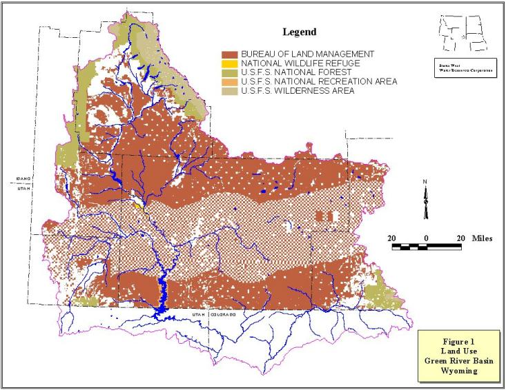
Sources of information for recreational uses and the importance of water for those include the Wyoming Department of State Parks and Cultural Resources, the Wyoming Game and Fish Department, the United States Forest Service (Bridger-Teton and Ashley National Forests), the U.S. Fish and Wildlife Service (Seedskadee National Wildlife Refuge or NWR) the Bureau of Land Management and the Bureau of Reclamation. Figure 1 shows the areas managed by the different agencies providing public use areas in the basin. The Wyoming Board of Outfitters and Professional Guides and the Wyoming Outfitters Association were both contacted for information. Because these groups primarily deal with big game hunting, and because fishing guides are currently not required to be licensed by the state, little data exist on guided fishing activities from these groups.
This technical memorandum addresses current recreational uses by category, followed by a more detailed description of some of the more popular (and more heavily used) water-based recreational sites in the basin. A discussion of watercourses determined to be eligible for inclusion in the Wild and Scenic River System is also provided.
Boating
Many of the basin's rivers and lakes are destinations for recreationists desiring to boat, water-ski or float (either whitewater, scenic or fishing) using watercraft. Areas heavily used by watercraft include the large lakes and reservoirs with boat ramps, and the larger rivers (e.g. the Green River Proper and the New Fork River). Smaller craft such as rafts and canoes do not require boat ramps and have access to more bodies of water and reaches of river. Boating is considered a non-consumptive use of water in that it occurs at lake levels and river flows largely determined by other uses.
Little quantitative data exist on the numbers of watercraft using these facilities and whether numbers approach or exceed the saturation capacity of the water body visited. The Bureau of Reclamation has indicated that, while not the rule on Wyoming waters, a ceiling capacity of one boat per ten surface acres of water is used elsewhere to measure use versus capacity. Unfortunately, current actual boating numbers on Green River Basin waters are generally not available from any of the land management agencies contacted. Usually, these numbers are more readily available where a permit process is required for boating (i.e. the Snake River in Grand Teton National Park).
One area where boating capacity is of concern relates to current use of the Green and New Fork Rivers. Recently receiving heavy pressure, these rivers are currently under study in areas where the agency maintains developed recreation sites and boating access. Typically, the BLM issues Special Recreation Permits (SRPs) to commercial outfitters for use of these sites and commercial use of the rivers. As of summer 2000, the BLM is issuing no new commercial permits to outfitters on these rivers, although existing permits are transferable in the event of a business changing hands (Martin Hudson, BLM, personal communication, July 2000). This issue is discussed further in the fishing section.
The Wyoming Game and Fish Department (WGF) Watercraft Officer was contacted to obtain information on the relative use versus capacity for boating in the Green River Basin. Unfortunately, this office also had no quantitative data on boat numbers. Indications from the officer were that most boat crowding problems are experienced in the eastern part of the state (e.g. Glendo Reservoir) (Russ Pollard, personal communication).
A quality boating experience requires a water level (in lakes) or flow rate (in rivers) sufficient to support the reason for boating, whether it be fishing, water-skiing or some other sport. In this context, future water development projects must be evaluated for their effect on such levels, and due to state and federal regulations will to some extent be designed and operated based upon recreational considerations.
Fishing
Fishing is a major water-based recreational activity pursued in the basin. From brook trout in tiny creeks in the Wind River and Wyoming Ranges to lake trout in Flaming Gorge Reservoir, fishing brings many visitors and residents to the region. As in boating, fishing is a non-consumptive use of water.
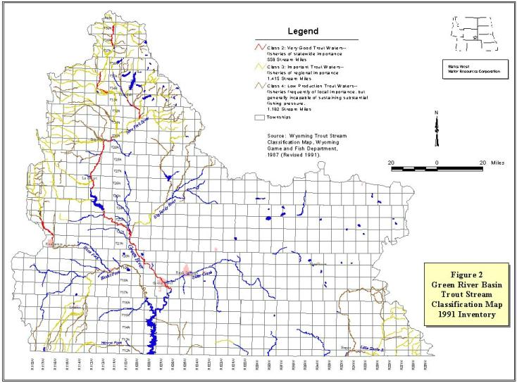
The State of Wyoming classifies trout streams under five designations (WGF, rev. 1991):
Figure 2 shows classifications of streams under this system within the Green River Basin. Interestingly, there exist no waters currently classified as Class 1 in the basin. The only Class 2 streams in the basin are certain segments of the main stem of the Green River above Flaming Gorge, and a segment of the New Fork River in the vicinity of Boulder. Nonetheless, the Green River Basin is considered by many to provide excellent trout fishing opportunities in its lakes, streams, rivers and backcountry areas.
The Wyoming Game and Fish Department (WGF) maintains the most complete database on fisheries and fisherman use in the state. In response to a request for fishing activity in the Green River Basin, the WGF provided the most recent estimate of annual standing water angling pressure (Mark Fowden, WGF personal communication, April 2000) of 85,097 angler days in the Pinedale Region and 400,473 in the Green River Region for a total of 485,570 angler days between the two. The breakdown by type of standing water is given in Table 1.
| Table 1. Recent Fishing Activity, Green River Basin: Angler Days by Standing Water Type | |||
|---|---|---|---|
| Pinedale Region | Green River Region | Total | |
| Unsuitable | 27 | 0 | 27 |
| Natural Alpine Lake | 59,286 | 2,974 | 62,260 |
| Alpine Reservoir | 7,875 | 1,029 | 8,904 |
| Natural Lowland Lake | 16,875 | 0 | 16,875 |
| Lowland Reservoir | 547 | 392,626 | 393,173 |
| Trout Farm Pond | 487 | 3,164 | 3,651 |
| Mixed Farm Pond | 0 | 680 | 680 |
| Non-Trout Farm Pond | 0 | 1 | 1 |
| Total | 85,097 | 400,474 | 485,571 |
The definition of alpine versus lowland in this list are whether the bodies of water are above or below an elevation of 7,500 feet. To be expected, the most obvious characteristic in the above information is the exploitation of relatively more alpine water in the Pinedale Region (due to the Wind River and Wyoming Ranges) compared to more lowland fishing in the Green River Region (dominated by Fontenelle and Flaming Gorge Reservoirs).
From angler surveys in 1979, 1985 and 1991, stream angling data were provided for Region 4, which included the Bear River Basin. Upon review of the responses for 1985, it was determined that approximately 91 percent of the total is attributable to stream fishing in the Green River and its tributaries, leaving about nine percent occurring in the Bear River Basin. Absent other data, this factor was applied to subsequent totals which also included Bear River data as a correction factor to more properly represent the Green River Basin only. Stream angler days are described in Table 2:
| Table 2. Fishing Activity, Green River Basin: Stream Angler Days | ||
|---|---|---|
| Region 4 | As Corrected for Green River Basin Only | |
| 1979 | 359,145 | 326,800* |
| 1985 | 238,153 | 217,142 (actual) |
| 1991 | 281,691 | 256,300* |
The WGF also has published a document entitled "A Strategic Plan for the Comprehensive Management of Wildlife in Wyoming, 1984-1989" (WGF, undated). This document gives total stream and lake sport fishing data in fisherman-days for the entire state as divided into five regions. Region 4 includes the Green, Bear and Little Snake River drainages. While the Bear River basin numbers are included, this basin is relatively quite small in comparison to the Green and Little Snake basins, both in geographic extent and in availability of fishable waters. Therefore, numbers provided for Region 4 have been reduced by nine percent as described above.
Not only are utilization (demand) data given, but this Strategic Plan document also estimates "supply" or "biological supply" of fishing opportunity available to the angler. As defined in the Strategic Plan, "Supply is based on present regulations, present stocking practices and the standards for success and size of fish which are present under `Management Framework.'" For 1988, the most recent year for which data are given in the report, supply and demand numbers are as follows:
| Table 3. Fishing Opportunity: Supply vs Demand, 1988 | |||
|---|---|---|---|
| Fisherman-Days or % | Supply on Public Lands or with Public Access |
% on Public Lands or with Public Access | Total Supply |
| Streams | 212,700* | 51.75% | 411,000* |
| Lakes and Reservoirs | 1,122,817 | 94.73% | 1,185,235 |
| Total | 1,335,517 | 82.87% | 1,596,235 |
| Fisherman-Days | Resident Demand | Nonresident Demand | Total Demand |
| Streams | 302,000* | 73,100 | 375,100* |
| Lakes and Reservoirs | 274,509 | 146,968 | 421,477 |
| Total | 576,509 | 220,068 | 796,577 |
According to the Strategic Plan document, total fishing demand was about 51 percent of available supply, with streams experiencing 91 percent utilization and lakes and reservoirs seeing 36 percent utilization (use as a percent of supply). Comparing Stream Angler supply to the values in Table 2 indicates that the following approximate utilization was seen: 1979 - 80 percent, 1985 - 53 percent and 1991 - 62 percent.
By comparison, in the 1970 Framework Water Plan (Wyoming Water Planning Program, September 1970) use and capacity data also were provided for lakes and streams by classification. That is, streams were described as Class 1, Class 2..Class 5, and reservoirs were classified as alpine, lowland or farm ponds, and as lakes or reservoirs as described earlier. The following table provides only the totals given in that document:
| Table 4. Estimated Fishing Use and Capacity, Green River Basin, 1969 | |||
|---|---|---|---|
| Fisherman-Days | Use | Capacity | Utilization |
| Streams | 322,675 | 701,961 | 46% |
| Lakes and Reservoirs | 427,035 | 555,516 | 77% |
| Totals | 749,710 | 1,257,477 | 60% |
Interestingly, the standing water utilization has appeared to decrease since 1969 while, more predictably, stream utilization has increased. Also, estimated capacity (or supply) numbers are significantly different comparing the earlier framework plan to the 1984-1989 Strategic Plan. It is felt that the possible discrepancies in the numbers can be explained due to:
Areas of potential use limitations are currently under evaluation by the BLM and Seedskadee NWR. Both these agencies have experienced significant increases in commercial use by outfitters. As described in the introduction, the BLM is now limiting the numbers of SRPs granted to outfitters for commercial use on the Green and New Fork Rivers. The BLM, in concert with other agencies, has been involved in a study entitled "Green River Corridor Interagency Management Plan," which is intended to address use of the Green River in Wyoming from its headwaters to Flaming Gorge. However, this document is not complete and a completion date is not firm. In addition, a user survey is underway to assess the characteristics and demographics of public use and access areas on federally managed lands. This survey is also not complete but may be by the end of 2000. Currently, the BLM has no published use numbers or demographics (i.e. private/commercial use proportion, fishing versus scenic or adventure trips, etc.) for the river (Martin Hudson, BLM, personal communication).
In the Green River Basin above Fontenelle Reservoir public access points are few and provide virtually the only access to the rivers which otherwise are bordered largely by private lands. Because of this, use is concentrated and high and opinions vary as to how this access is to be managed. About half the commercial use of the access sites originates with guide services out of Jackson, Wyoming, who in general would like to see more access provided. Local opinion appears to want to keep the status quo to minimize future increases in traffic.
Seedskadee NWR has stopped issuing commercial permits and will let the current number of outstanding permits diminish through attrition from the existing seven to four. The primary reason for restrictions at Seedskadee are the concerns of unregulated sportfishing growth (as experienced on the Green River below Flaming Gorge) combined with the relatively low fish-per-mile numbers seen on the NWR when compared against other tailwater fisheries (USFWS, March 2000).
The resulting analysis of fishing use data indicates that overall utilization remains below the capacity of the resource. Recent WGF planning documents have moved away from publishing "supply versus demand" analyses, so current utilization numbers are unavailable. All indications are, however, that the Green River Basin maintains a sufficient fishery resource for a current and near future high-quality fishing experience.
Waterfowl Hunting
The harvest of migratory waterfowl is a recreational pursuit affected by the presence or absence of water. Wetlands and open water are needed for breeding, nesting, rearing, feeding and isolation from land-based predators. In the Green River Basin of Wyoming, waterfowl hunting is pursued where sufficient local or migratory populations are available. The two most heavily hunted areas are the Seedskadee National Wildlife Refuge (no. 1) and the Farson-Eden-Big Sandy area (no. 2) (Steve Tessman, WGF, personal communication, June 2000). The Green and Little Snake River Basins are located in the Pacific Flyway (Larry Roberts, WGD, personal communication, June 2000).
The setting of nation-wide waterfowl hunting seasons and bag limits is performed by the U.S. Fish and Wildlife Service (USFWS). Since 1995, the USFWS has set seasons to manage duck harvest rates under the concept of "Adaptive Harvest Management" or AHM (USFWS, 1999). This concept is described by the USFWS as follows:
The annual process of setting duck-hunting regulations in the United States is based on a system of resource monitoring, data analysis, and rule making. Each year, monitoring activities such as aerial surveys and hunter questionnaires provide information on harvest levels, population size, and habitat conditions. Data collected from this monitoring program are analyzed each year, and proposals for duck-hunting regulations are developed by Flyway Councils, States, and the U.S. Fish and Wildlife Service (USFWS). After extensive public review, the USFWS announces a regulatory framework within which States can set their hunting seasons.
Essentially, AHM allows annual duck population surveys and hunter input to re-evaluate seasons and harvest on an annual basis. States are then allowed to impose more stringent seasons and bag limits than the USFWS sets, if they wish. As populations increase above the desired population goal, hunting seasons and bag limits are made more liberal, while population decreases have the opposite effect. The primary population studied by the USFWS is the midcontinent mallard stock, with efforts underway to include other stocks and species. In recent years, duck populations have been strong and liberal seasons and bag limits have benefited sportsmen. This is especially true for the Pacific Flyway, which recently has seen longer seasons than the other flyways.
The general determination of duck hunting opportunities therefore is affected by extra-State duck populations and federal regulations. This is different from most all other hunting and fishing activities, where bag limits and seasons reflect local populations as reflected in WGF research and evaluations. According to the WGF (Steve Tessman, ibid), hunters in the Green River Basin harvest mostly local ducks (those that nest and breed in the basin). Because of this, nationally-based regulations may not reflect the origin of birds in the bags of local hunters, even though they form the basis for local season- setting. Therefore, it is possible for local water development projects to adversely affect local duck populations (and hunter success) if breeding and nesting sites suffer net loss, even as continental populations continue to rise.
Hunter-days and harvest numbers for recent duck hunting seasons are provided by the WGF in Table 5. The WGF has in recent years determined not to publish use goals or harvest objectives for waterfowl, even though this practice occurred in the late 80s and early 90s. The reason, according to Tessman, is partly due to the difficulty in defining an objective "capacity" value. The maximum number of sportsmen afield before the quality of the experience suffers varies from one hunter to the next. To a non-resident, accustomed to hunting in more crowded surroundings, many hunters in an area may not be troublesome. To a resident accustomed to years of hunting the old haunts alone, even only one other party a mile away could be more than desirable. Therefore, the agency no longer defines the maximum, or desired number of hunters afield or hunter days for a given management area.
| Table 5. Duck Hunter and Harvest Data, 1994-998 | ||||
|---|---|---|---|---|
| Management Area | ||||
| Name | Number | No. Hunters | Hunter Days | Harvest |
| 1994 | ||||
| Upper Green | 5B | 329 | 1,276 | 2,000 |
| Great Divide | 5E | 59 | 212 | 87 |
| Lower Green | 5F | 255 | 1,175 | 1,313 |
| Ham's Fork-Black's Fork | 5G | 186 | 923 | 1,095 |
| Little Snake | 5I | 22 | 56 | 60 |
| Total | 851 | 3,642 | 4,555 | |
| 1995 | ||||
| Upper Green | 5B | 270 | 1,294 | 1,568 |
| Great Divide | 5E | 78 | 327 | 239 |
| Lower Green | 5F | 360 | 1,647 | 2,174 |
| Ham's Fork-Black's Fork | 5G | 230 | 1,220 | 1,843 |
| Little Snake | 5I | 42 | 296 | 275 |
| Total | 980 | 4,784 | 6,099 | |
| 1996 | ||||
| Upper Green | 5B | 556 | 2,570 | 4,395 |
| Great Divide | 5E | 31 | 241 | 94 |
| Lower Green | 5F | 409 | 2,402 | 4,909 |
| Ham's Fork-Black's Fork | 5G | 357 | 2,182 | 2,853 |
| Little Snake | 5I | 63 | 441 | 420 |
| Total | 1,416 | 7,836 | 12,671 | |
| 1997 | ||||
| Upper Green | 5B | 212 | 1,307 | 1,682 |
| Great Divide | 5E | 7 | 28 | 14 |
| Lower Green | 5F | 296 | 1,852 | 3,641 |
| Ham's Fork-Black's Fork | 5G | 233 | 1,498 | 2,531 |
| Little Snake | 5I | 28 | 98 | 155 |
| Total | 776 | 4,783 | 8,023 | |
| 1998 | ||||
| Upper Green | 5B | 369 | 2,623 | 4,724 |
| Great Divide | 5E | 38 | 229 | 318 |
| Lower Green | 5F | 235 | 1,177 | 1,375 |
| Ham's Fork-Black's Fork | 5G | 280 | 2,139 | 3,622 |
| Little Snake | 5I | 38 | 127 | 159 |
| Total | 960 | 6,295 | 10,198 | |
The last year "objectives" were published by WGF for duck hunting was 1993. For comparison only, the agency in that year listed the following (Larry Roberts, WGF, personal communication, June 2000):
| Table 6. Management Objectives for Duck Hunting, Green River Basin, 1993 | |||
|---|---|---|---|
| Management Area | No. Hunters | No. Hunter Days | Harvest |
| Upper Green River | 500 | 2,000 | 3,000 |
| Lower Green River | 700 | 3,000 | 4,200 |
Regardless of how these objectives were set, or why they were discontinued, it is interesting to note that they have been exceeded only twice in the Upper Green River Management Area, in 1996 and 1998, and once in the Lower Green (1996). Harvest objectives are not currently used (post-1993), because harvest is taken into account in the setting of season length and bag limits by the USFWS using AHM. In effect, the desired harvest is a prospective number using past hunter success, population effects, and regulations in concert with current-year populations. With current duck populations and hunting pressure, it appears there is a sufficient resource to provide a quality duck hunting experience now and in the near future, with the existing water resources of the basin.
In like fashion, goose hunting seasons and bag limits are set under guidelines from the USFWS, although states have more flexibility in setting bag and possession limits. And like duck populations, goose populations are strong and increasing. With approval from USFWS, states can set special seasons to allow depredation harvest from growing local flocks. According to historic estimates, the Rocky Mountain Population (RMP) of Canada geese has grown approximately four-fold since 1972 (Wilkins and Cooch, 1999). Since 1989, populations have increased at a rate of eight percent per year.
Prior to current regulations by the USFWS, the State of Wyoming set Management Objectives for annual goose hunting and harvest. Larry Roberts (ibid) provided historic information from WGF files for Table 7:
| Table 7. Historic Goose Management Objectives | |||||
|---|---|---|---|---|---|
| Management Area | 1978 | 1983 | 1988 | 1993 | |
| Upper Green | No. of Hunters | 130 | 180 | 250 | 350 |
| Harvest, animals/day | 0.23 | 0.23 | 0.23 | 0.25 | |
| Actual Hunter Days | 1,750 | ||||
| Total Harvest, animals | 438 | ||||
| Lower Green | No. of Hunters | 290 | 320 | 400 | 475 |
| Harvest, animals/day | 0.6 | 0.6 | 0.8 | 0.8 | |
| Actual Hunter Days | 2,375 | ||||
| Total Harvest, animals | 380 | ||||
Hunter-days and harvest numbers for recent goose hunting seasons are provided by the WGF in Table 8. Again, because of the recent upward trends in populations, it appears there is a sufficient resource to provide a quality goose hunting experience now and in the near future, with the existing water resources of the basin. However, because the Rocky Mountain Population nests and breeds locally, it is possible for local water development projects to adversely affect local goose populations (and hunter success) if breeding and nesting sites suffer net loss, even as continental populations continue to rise.
| Table 8. Goose Hunter and Harvest Data, 1994-998 | ||||
|---|---|---|---|---|
| Management Area | ||||
| Name | Number | No. Hunters | Hunter Days | Harvest |
| 1994 | ||||
| Upper Green | 5B | 211 | 679 | 176 |
| Great Divide | 5E | 43 | 110 | 26 |
| Lower Green | 5F | 205 | 799 | 341 |
| Ham's Fork-Black's Fork | 5G | 92 | 426 | 305 |
| Little Snake | 5I | 25 | 96 | 100 |
| Total | 576 | 2,110 | 948 | |
| 1995 | ||||
| Upper Green | 5B | 209 | 799 | 449 |
| Great Divide | 5E | 51 | 234 | 27 |
| Lower Green | 5F | 275 | 1,209 | 234 |
| Ham's Fork-Black's Fork | 5G | 148 | 938 | 425 |
| Little Snake | 5I | 29 | 176 | 64 |
| Total | 712 | 3,356 | 1,199 | |
| 1996 | ||||
| Upper Green | 5B | 499 | 2,236 | 726 |
| Great Divide | 5E | 11 | 11 | 0 |
| Lower Green | 5F | 341 | 1,827 | 829 |
| Ham's Fork-Black's Fork | 5G | 318 | 1,555 | 590 |
| Little Snake | 5I | 34 | 193 | 238 |
| Total | 1,203 | 5,822 | 2,383 | |
| 1997 | ||||
| Upper Green | 5B | 190 | 1,152 | 784 |
| Great Divide | 5E | 7 | 28 | 7 |
| Lower Green | 5F | 212 | 1,357 | 558 |
| Ham's Fork-Black's Fork | 5G | 134 | 834 | 190 |
| Little Snake | 5I | 14 | 42 | 42 |
| Total | 557 | 3,413 | 1,581 | |
| 1998 | ||||
| Upper Green | 5B | 343 | 1,999 | 827 |
| Great Divide | 5E | 19 | 82 | 38 |
| Lower Green | 5F | 210 | 1,107 | 598 |
| Ham's Fork-Black's Fork | 5G | 203 | 1,069 | 407 |
| Little Snake | 5I | 19 | 31 | 6 |
| Total | 794 | 4,288 | 1,876 | |
Swimming
Swimming is generally undertaken incidental to other activities. While some lakes and reservoirs are suitable for swimming and waterskiing (i.e. Flaming Gorge, Fontenelle) many are too cold for comfort, or have bottom strata that are not conducive to swimming.
Wild and Scenic River Candidates
The Resource Management Plan (BLM, 1996) for the Green River Resource Area, administered by the BLM, studied a number of river segments in the Green River Basin for possible designation under the Wild and Scenic Rivers Act. Initially, 183 waterways or waterway segments were reviewed for eligibility. Of these, 175 were found ".not to have any outstandingly remarkable values and were dropped from further consideration."
The remaining eight segments were then reviewed for suitability for classification under the system. No segments in the Green River basin were ultimately determined suitable for inclusion. The primary reasons given for "Not Suitable" determination include landowner conflicts, ability to manage the segment, lack of interest for designation and potential use conflicts. The final eight waterways under consideration included the Red Creek Unit, Currant Creek Unit, Pacific Creek, North Fork of Bear Creek, Canyon Creek, and the Green and Big Sandy Rivers.
The Upper Green Landscape Assessment (Bridger-Teton National Forest, May, 1999) lists the entire segment of the Upper Green River, from its source to the Forest Boundary, as a Study River for Wild and Scenic designation. The river is considered as eligible for designation as a Wild River above Green River Lakes, and as a Scenic River from Lower Green River Lake to the Forest Boundary. Two tributaries are also eligible as Wild Rivers: Tosi Creek and Roaring Fork Creek. Suitability determination information was unavailable, and formal designation has not yet been made.
No rivers on the Medicine Bow - Routt National Forest (Hayden District, east of Baggs/Dixon in the Little Snake River drainage) were determined eligible in the 1985 Forest Plan. However, this document is currently undergoing revision. According to Dee Hines, Forest Planner (personal communication, July 2000) no rivers of national importance have been identified in areas that drain to the Little Snake River. However, segments of local importance are still under study and may be identified for eligibility by the end of the year. If any stream segments are determined eligible for designation, the Forest does not plan to immediately pursue suitability evaluation.
Review of Major Water-Based Recreation Destinations
Information and data obtained from resource managers has been compiled to give the following descriptions of the basin's most popular recreation destinations:
Flaming Gorge National Recreation Area (NRA)
Flaming Gorge straddles the Wyoming-Utah state line and provides significant opportunities for fishing, boating for pleasure, waterskiing, camping and other leisure activities. The Flaming Gorge Ranger District of the Ashley National Forest manages recreation activities at this reservoir, even though it is a Bureau of Reclamation dam. Main boating access to the reservoir is provided by three marinas: Buckboard (WY), Lucerne (UT) and Cedar Springs (UT). Numerous smaller boat launch sites exist.
Recreation use on the Flaming Gorge District has more than doubled since 1988. In 1988, a total of 883,000 recreation days were logged, of which 101,400 (11 percent) were in the Wyoming part of the NRA (Eileen Richmond, District Ranger, letter of June 6, 2000). From 1988 to 1996, a total of 8,786,800 recreation days were spent on the District, of which 1,117,600 (12.7 percent) were on the Wyoming part. Data are not available for 1997 or 1998. In 1999, it was estimated that the NRA saw over 2 million visitors. Assuming the same percentage as seen from 1988-1996, the Wyoming side saw approximately 254,000 visitors in 1999.
The three major marinas at Flaming Gorge all have plans for expansion, including the addition of RV parks, shower facilities and restaurants. Operated under Special Use permits, these marinas are required to submit operating plans to the District. A new marina is planned for the Firehole area in Wyoming. Privatization at Dutch John, Utah, is expected to increase the number of and competition among businesses there. The District believes that privatization will allow local business to meet the future needs of recreationists. Visitation to the Flaming Gorge NRA is expected to mimic the growth patterns seen in the major metropolitan areas of Denver and the Wasatch Front of Utah.
Fontenelle Reservoir
Fontenelle Reservoir is a Bureau of Reclamation dam on the main stem of the Green approximately 50 miles northwest of the City of Green River. Since 1993 recreation activities have been managed by the Bureau of Land Management, Rock Springs Office. The lake side includes two boat ramps. Four campgrounds exist, including the Fontenelle Creek Recreation Area and Weeping Rock and Tailrace Campgrounds below the dam. Slate Creek Campground is about five miles further downstream of the dam. The primary recreation activity logged at Fontenelle is fishing. Fontenelle is a no-fee area. Visitor days at Fontenelle from 1990-1996 are as follows, provided by the Bureau of Reclamation (Tammie Risley, USBR, personal communication):
| 1990 - 14,500 | 1991 - 16,000 | 1992 - 16,500 | 1993 - 10,500 |
| 1994 - 13,500 | 1995 - 11,700 | 1996 - 11,700 |
Meeks Cabin Reservoir
Meeks Cabin Dam is a Bureau of Reclamation project on the Black's Fork River. While the dam is in Wyoming, the reservoir straddles the Wyoming/Utah state line. Recreation at the reservoir is managed by the Uinta/Wasatch-Cache National Forest in Evanston WY. Primary recreation activities logged at the site include camping, picnicking and boating, although no boat ramps are reported at the site. Meeks Cabin Reservoir is a fee area for recreationists.
Visitor days at Meeks Cabin from 1990-1996 follow (Risley, ibid):
| 1990 - 1,642 | 1991 - 1,901 | 1992 - 7,540 | 1993 - 7,016 |
| 1994 - 7,600 | 1995 - 9,200 | 1996 - 9,350 |
Stateline Reservoir
Stateline Dam is a bureau of Reclamation project located in Utah, less than a mile from the WY state line. While the facilities are in Utah, many recreationists also visit USFS lands below the dam in Wyoming. The reservoir has one campground and one boat ramp. Stateline Reservoir is a fee area for recreationists.
Visitor days at Stateline from 1990-1996 follow (Risley, ibid):
| 1990 - 5,600 | 1991 - 1,800 | 1992 - 1,800 | 1993 - 1,600 |
| 1994 - 2,200 | 1995 - 2,200 | 1996 - 1,750 |
Big Sandy Reservoir
Big Sandy Dam is a Bureau of Reclamation project on the Big Sandy River approximately 10 miles north of Farson. Very little maintenance is performed at Big Sandy other than trash hauling. Prior to 1996 the area was managed by the State of Wyoming. Since then, recreation management has reverted to the Bureau of Reclamation. The primary recreation activity logged at the site is camping, although fishing is also a popular activity. Big Sandy includes one boat ramp and three campgrounds, and is a no-fee area. From 1990-1996, visitation was estimated at 2,000 recreation days per year (Risley, ibid).
Seedskadee National Wildlife Refuge (NWR)
Seedskadee NWR was conceived and constructed as environmental mitigation following construction of Flaming Gorge and Fontenelle dams. The refuge covers over 36 miles of the main stem of the Green River from the upper boundary (approximately 2.5 miles below the CCC Bridge) to just below the "Big Island," approximately 20 miles northwest of Green River. The NWR does not allow camping, although camping is available at the Bureau of Land Management Slate Creek Campground and at Weeping Rock and Tailrace Campgrounds, all located between Fontenelle Dam and the upstream Refuge boundary. The NWR is a no fee area.
Primary activities on the NWR include fishing, hunting, boating and sightseeing. No formal visitation numbers are kept, however Refuge personnel estimate recent visitation at approximately 10,000 to 15,000 recreationists per year (Susan Beauchaine, USFWS, April 2000, personal communication), a number which is visibly increasing. Seedskadee NWR has recently suspended issuance of commercial sport fishing permits to outfitters and will let the current number of outstanding permits diminish through attrition from the existing seven to four. The primary reason for restrictions at Seedskadee are the concerns of unregulated sportfishing growth (as experienced on the Green River below Flaming Gorge) combined with the relatively low fish-per-mile numbers seen on the NWR when compared against other tailwater fisheries.
Pinedale District
The Upper Green Landscape Assessment (Bridger-Teton National Forest, May, 1999) describes dispersed and developed recreational opportunities in the District, and many sites are associated with water-based recreation (e.g. fishing, boating). Dispersed sites are generally unimproved and see use during the summer and hunting seasons. Actual use rates are not kept for dispersed sites. A total of 56 dispersed sites have been identified in the Upper Green River corridor.
Developed sites include managed campground areas, group sites and boat sites. In the Pinedale District, there 11 campgrounds, six boat sites, six "minor visitation" sites, seven developed trailheads, and one each defined as fishing, swimming and picnic sites. Total capacity of the developed sites is expressed in units of "people at one time," or PAOT. In the Pinedale District, total capacity is calculated to be 3,929 PAOT at the developed sites (Lis Novak, personal communication). On a seasonal basis, approximately 454,800 PAOT-days are available (which assumes an average 115 day season among the various sites).
Examples of actual use for two campgrounds is provided in the Landscape Plan, and are reproduced in Table 9:
| Table 9. Developed Site Occupancy for 1998 | ||||
|---|---|---|---|---|
| Campground | June | July | August | September |
| Green River Lakes 39 family sites, 3 group sites, 1 boat site: 195 PAOT | 11% | 65% | 68% | 23% |
| Whiskey Grove 9 camping sites: 45 PAOT |
2% | 16% | 50% | 22% |
Big Piney District
The Big Piney District has significantly fewer developed sites and PAOT capacity than the Pinedale District. The Big Piney District lists 2 campgrounds, 5 developed trailheads, 2 winter sites and one boat site. Total capacity is given as 55,110 PAOT-days. No actual use numbers were provided, but it is understood that use rates are less than seen in the Pinedale District.
Kemmerer District
This District lists four campgrounds, 5 picnic sites, and one developed trailhead with a total capacity of 59,830 PAOT-days. However, only one site, the Ham's Fork campground, is within the Green River drainage. This site has an annual capacity of 9,750 PAOT-days.
The most recent recreation information available for this Forest is included in the "Final Environmental Impact Statement, Medicine Bow National Forest and Thunder Basin National Grassland" (USFS, 1985a) and in the "Medicine Bow National Forest and Thunder Basin National Grassland Land and Resource Management Plan" (USFS, 1985b) which is currently undergoing revision. However, this plan does not divide capacity or use information by drainage, so the condition of that part of the Forest within the Green River Basin (by being tributary to the Little Snake River) is not explicitly available. In general, the Forest believes their dispersed recreation capacity will exceed demand well into the future. In 1980, dispersed recreation use was estimated to be no more than 21 percent of capacity.
Developed use, at the time of preparation of the referenced documents, was approximately 22 percent below capacity. However, this is a seasonal number, and weekend and holiday uses usually exceeded capacity. By 2030, the Forest expected demand to exceed 1980 capacity for use by 1.8 times.
Most activity on the Ashley National Forest is associated with Flaming Gorge NRA. On the Wasatch- Cache, activity is mainly linked to Stateline and Meeks Cabin Reservoirs. Little information is available on use or capacity of water-based recreation on the units (other than listed for these reservoirs) largely due to the relatively small amount of lands in Wyoming.
The Bureau of Land Management (BLM) administers lands within the Green River Basin through four different field offices under the jurisdiction of the Rock Springs and Rawlins Districts. Little to no water-based recreation on BLM lands occurs on Rawlins District lands in the basin, which include the Little Snake River Basin and the eastern portion of the Great Divide Basin. The Rock Springs, Pinedale and Kemmerer Field Offices, all in the Rock Springs District, do manage water-related recreation at various sites in the basin.
The BLM manages both dispersed and developed recreation activities on agency-administered lands in the Green River Basin. In addition to the campgrounds at or near Fontenelle Reservoir described above, the BLM manages seven additional developed recreation sites. Of these, five offer access to boating, fishing or waterfowl hunting. These five sites include the Scab Creek Trailhead, Boulder Lake Recreation Site, Upper Green River Recreation Area, Warren Bridge Campground and the New Fork Campground. No data are kept on use rates of developed campsites (other than those listed above as specific destinations). The State Office (Mr. Mark Goldbach, personal communication) indicates that per campsite capacity (5 PAOT per individual site), however, is likely similar to values published for the Forest Service. Mr. Goldbach is unaware of campground or dispersed camping capacity constraints at this time. Table 10 shows the current recreation visitor use levels (for water-related activities) seen in areas administered by the field offices described earlier. An area of concern, however, is the use of the Green and New Fork Rivers by commercial fishing outfitters. The BLM issues Special Recreation Permits (SRP) to commercial outfitters for access to waters under BLM jurisdiction. Because of recent heavy use by outfitters of the Green and New Fork Rivers (i.e. float trips), the BLM has suspended issuance of additional SRPs until a study of the rivers is completed.
| Table 10. Visitor Activity at Selected BLM Locations | ||||
|---|---|---|---|---|
| Field Office Name | Activity | No. Participants | Visitor Days | SRP Count1 |
| Rock Springs | ||||
| Camping | 21,905 | 86,363 | ||
| Fishing and Hunting | 74,442 | 37,635 | ||
| Fishing | 2 | |||
| Pinedale | ||||
| Camping | 5,418 | 7,141 | ||
| Fishing and Hunting | 35,270 | 8,069 | ||
| Misc. Water Activities | 191,991 | 10,297 | ||
| Boating-nonmotorized | 7 | |||
| Fishing | 15 | |||
| Kemmerer | ||||
| Camping | 3,066 | 8,731 | ||
| Fishing and Hunting | 5,649 | 6,209 | ||
| no water-related
SRPs | ||||
Lake Viva Naughton, on the Ham's Fork north of Kemmerer, is located on lands owned by PacifiCorp (recently acquired by Scottish Power). Access to lands surrounding the lake, and the one existing marina, are operated under a lease agreement by Viva Naughton Marina. Exceptions to this are two Wyoming Game and Fish parking areas, one each on the north and south sides of the lake. Other than the WGF parking areas, access is by fee paid to the marina operator.
Wyoming State Parks and Historic Sites
There are no State Parks in the Green River Basin or the Great Divide Basin. The only State Historic Site (SHS) in either basin is at Fort Bridger. Data collected by the former Division of State Parks & Historic Sites (under the former Department of Commerce), however, does provide insight into travel habits and desires of recreationists visiting state sites, which is of value if extrapolated to tourist destinations in general.
The Visitor Use Program for 1993-1997 contains useful information concerning site visitation. Interestingly, for the 1993-1997 period, Fort Bridger SHS averaged 87,708 visitors per year, more than any other SHS. This value is also more than the attendance at 9 of 14 (64 percent) of the State Parks. The bulk of the visits occur in the June through September period.
The 1997 Wyoming State Parks and Historic Sites Visitor Survey, compiled by the University of Wyoming, Survey Research Center, provides additional information. About 86 percent of all visitation (to all parks and historic sites) occurs in the months of June, July and August, with attendance in each of those months almost equal. Slightly over half the visitors are first-time visitors. Approximately one in four visitors is traveling with a boat or canoe, indicating some water-based recreation is intended, either at that location or elsewhere on that particular trip. Approximately 58 percent of the visitors are from out of state.
The stated water-related activities undertaken by visitors while they were at a park or historic site included:
		28.1%		Nature/Wildlife Viewing
		24.5%		Swimming
		9.7%		Water Skiing
		23.5%		Fishing
		18.4%		Boating
While these data describe statewide visitation to all parks and historic sites, some of which expressly provide water-based activities (such as Glendo or Boysen), it does indicate that a significant percentage of summer recreationists explicitly pursue water-related recreation.
Additional data exist pointing to the importance of these state sites, and presumably other non-state destinations as well, to the vacationer and recreationist. Almost 79 percent say that the particular site they visited was important to their recreational activities. A similar number say the park/site they visited was adequate for current and future visitors. Over 91 percent said it is important to preserve park lands/historic sites for future generations. Finally, over 63 percent said they either have visited, or plan to visit, other parks/sites in the same summer.
References
Beauchaine, Susan, USFWS, April 2000, personal communication.
Bureau of Land Management, Rock Springs District Office, March 1996, Green River Resource Area Resource Management Plan and Final Environmental Impact Statement, Vols. 1 and 2 of 2, U.S. Department of the Interior.
Fowden, Mark, Wyoming Game and Fish Department, April 2000, personal communication.
Hines, Dee, Medicine Bow - Routt National Forest, July 6, 2000, personal communication.
Hudson, Martin, BLM Recreation Planner, Pinedale Office, July 2000, personal communication.
Novak, Lis, Bridger-Teton National Forest, June 2000, personal communication.
Pollard, Russ, Wyoming Game and Fish Department, June 2000, personal communication.
Richmond, Eileen, District Ranger, Flaming Gorge Ranger District, Ashley National Forest, June 6, 2000, personal communication (letter).
Risley, Tammie, USBR, June 13, 2000, Recreation Visitation Reports.
Roberts, Larry, Wyoming Game and Fish Department, June 12, 2000, personal communication.
Simpson, Donald, Deputy State Director, Resources Policy and Management, BLM Wyoming State Office, April 7, 2000, personal communication (letter).
Tessman, Steve, Wyoming Game and Fish Department, June 2000, personal communication.
University of Wyoming, Survey Research Center, 1997, Wyoming State Parks and Historic Sites Visitor Survey.
USFS, 1985a, "Final Environmental Impact Statement, Medicine Bow National Forest and Thunder Basin National Grassland."
USFS, 1985b, "Medicine Bow National Forest and Thunder Basin National Grassland Land and Resource Management Plan"
USFWS, 1999, Adaptive Harvest Management, 1999 Duck Hunting Season
USFWS, Seedskadee National Wildlife Refuge, March 2000, "DRAFT Operating Plan: Commercial Outfitting for Sport Fishing on Seedskadee National Wildlife Refuge."
Wilkins, K. A. and E. G. Cooch, 1999. Waterfowl Population Status, 1999. U. S. Fish and Wildlife Service, Department of the Interior, Washington D.C. 33 pp + appendices.
Wyoming Department of State Parks and Historic Sites, Visitor Use Program, 1993-1997.
Wyoming Game and Fish Department, various, Angler Surveys.
Wyoming Game and Fish Department, undated, A Strategic Plan for the Comprehensive Management of Wildlife in Wyoming, 1984-1989, Vol. III.
Wyoming Game and Fish Department, 1991 (rev), Wyoming Trout Stream Classification Map.
Wyoming Game and Fish Department, 1994-1998, Annual Report of Upland Game and Furbearer Harvest.
Wyoming Game and Fish Department, 1998, Annual Report.
Wyoming Water Planning Program, September 1970, "Water and Related Land Resources of the Green River Basin, Wyoming," Wyoming Water Planning Program Report No. 3, Wyoming State Engineer's Office.