Wyoming State Water Plan
Wyoming State Water Plan
Wyoming Water Development Office
6920 Yellowtail Rd
Cheyenne, WY 82002
Phone: 307-777-7626

Wyoming Water Development Office
6920 Yellowtail Rd
Cheyenne, WY 82002
Phone: 307-777-7626


As authorized by the Wyoming Water Development Commission in its contract scope of work,
this planning document presents current and proposed (estimated) future uses of water in
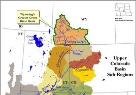
Wyoming's Green River Basin. Uses to be inventoried include agricultural, municipal,
industrial, environmental, and recreation. Both surface and ground water uses, as well
as overall water quality are described. Given current uses, the availability of surface
and ground water to meet future requirements is estimated. To lay the groundwork for
future water development, a review of the current institutional and legal framework facing
such projects is presented. Finally, thoughts are given to guide implementation of the water
planning process.
The structure of this final report is to present findings in enough detail to explain the
overall plan without deluging the reader in technical minutiae. Technical memoranda have
been prepared which delve into the many individual topics in detail, and it is to these
documents the reader should turn for answers to questions about details, methods, and for
selected references. No separate list of citations is provided herein other than for the
Technical Memoranda (which, individually, contain complete bibliographies).
Low Res PDF(3,245kb) or High Res PDF(22,411kb) Access the 2001 Green River Basin Plan Final Report
HTML; Low Res PDF(176kb) or High Res PDF(2,779kb) The Green River Basin Water Planning Process document is one of two basin water plans compiled under initial efforts of the Wyoming Water Development Commission.
HTML; Low Res PDF(1,082kb) or High Res PDF(7,598kb) This chapter describes and quantifies the various current uses made of water in the Green River Basin.
HTML; Low Res PDF(883kb) or High Res PDF(9,812kb) This chapter presents estimates of the availability of both surface water and ground water for future uses.
HTML; Low Res PDF(161kb) or High Res PDF(324kb) For assessing the need for water into the future, this plan has developed estimates of water demand for each major use category out to year 2030.
HTML; Low Res PDF(837kb) or High Res PDF(1,800kb) A review of the completed planning studies, future basin demands, compact considerationgs and water supply opportunities for the Green River Basin
HTML; Low Res PDF(27kb) For purposes of this report, plan implementation is the series of tasks to be sequentially and periodically assessed and undertaken so that the planning information is current and accurate, funding mechanisms are protected or enhanced, and law and policy implications on plan implementation are both comprehended and closely monitored.
HTML; PDF (118kb) Access the 2010 Green River Basin Plan Executive Summary here
| ||||||||||||
* Please note that these files are in read only format. Any changes to the models made by the user may change the results and must be saved with a new file name.
** For Windows XP users - Due to additional security levels, XP users may have to manually change their security levels. If you receive a message when opening Microsoft Excel that reads as follows: "Macros in this workbook are disabled because the security level is high..." click OK and perform the following routine: Under the Tools menu, click on Macro then Security. Change the Security Level to Medium, this will enable the user to go to the Spreadsheet Model Main Menu.
The 2001 Green River Basin Water Plan Technical Memoranda are listed in the table below. The memoranda may be viewed in either html or PDF. The PDF version requires Adobe Acrobat® Reader. If you do not already have this program on your computer, please visit Adobe's Website to download a free copy. In addition, the Technical Memoranda contain download options for both high resolution and low resolution PDF. The high resolution documents provide high quality images and photos and are recommended for printing purposes, while the low resolution documents have a smaller file size and are recommended for viewing only. Please note the size of the file when deciding which to view or print.
| HTML | PDF (low resolution) |
PDF (high resolution) |
Technical Memoranda |
| Chapter I | |||
| 80 kb | 97 kb | --- | Wyoming Water Law Summary |
| 148 kb | 125 kb | --- | Summary of Interstate Compacts |
| Chapter II | |||
| >99 kb | 107 kb | 772 kb | Basin Water Use Profile - Agriculture |
| 175 kb | 283 kb | 750 kb | Cropping Patterns in the Basin |
| 362 kb | 1,537 kb | 6,226 kb | Irrigated Lands and Permit GIS Data |
| 73 kb | 78 kb | --- | Basin Water Use Profile - Municipal |
| 15 kb | 20 kb | --- | Basin Water Use Profile - Domestic |
| 51 kb | 56 kb | --- | Basin Water Use Profile - Industrial |
| 229 kb | 376 kb | 1,316 kb | Recreational Uses |
| 249 kb | 693 kb | 2,425 kb | Environmental Uses |
| 296 kb | 707 kb | 3,874 kb | Major Reservoir Information |
| 63 kb | 120 kb | 445 kb | Instream Flows in Wyoming |
| 323 kb | 1,835 kb | 4,217 kb | Surface Water Quality |
| 85 kb | 179 kb | 622 kb | Colorado River Basin Salinity Control Program |
| Chapter III | |||
| 181 kb | 221 kb | 690 kb | Surface Water Data Collection and Study Period Selection |
| 360 kb | 578 kb | 1,476 kb | Surface Water Data Synthesis and Spreadsheet Model Development |
| 184 kb | 219 kb | --- | Available Surface Water Determination |
| 701 kb | 1,290 kb | 5,674 kb | Available Ground Water Determination |
| Chapter IV | |||
| 246 kb | 602 kb | 1,962 kb | Irrigation Water Needs and Demand Projections |
| 95 kb | 41 kb | --- | Population Projections |
| 111 kb | 56 kb | --- | Industrial Water Needs Projections |
| 110 kb | 63 kb | --- | Future Recreational and Environmental Water Requirements |
| Chapter V | |||
| 188 kb | 204 kb | 2,091 kb | Criteria for Screening Future Water Use Opportunities |
| 123 kb | 132 kb | 836 kb | Water Conservation |
| 46 kb | 49 kb | --- | Institutional Constraints |
| Addendum | |||
| 26 kb | 29 kb | --- | Wyoming Depletions in the Little Snake River Basin |
| Diversions | |||
| 56 kb | 70 kb | --- | Irrigation Diversion Operation and Description |
| 136 kb | 114 kb | 1,479 kb | Water Division 1, District 8 |
| 75 kb | 92 kb | --- | Water Division 4, District 3 |
| 57 kb | 67 kb | --- | Water Division 4, District 5 |
| 106 kb | 79 kb | 1,114 kb | Water Division 4, District 6 |
| 1,090 kb | 865 kb | 1,139 kb | Water Division 4, District 7 |
| 51 kb | 69 kb | --- | Water Division 4, District 9 |
| 510 kb | 529 kb | 3,766 kb | Water Division 4, District 10 |
| 278 kb | 297 kb | --- | Water Division 4, District 11 |
| 27 kb | 36 kb | --- | Water Division 4, District 14 |
| 284 kb | 268 kb | 1,206 kb | Water Division 4, District 15 |