Wyoming State Water Plan
Wyoming State Water Plan
Wyoming Water Development Office
6920 Yellowtail Rd
Cheyenne, WY 82002
Phone: 307-777-7626

Wyoming Water Development Office
6920 Yellowtail Rd
Cheyenne, WY 82002
Phone: 307-777-7626


As with all chapters in this final plan report, explicit lists of references are not provided. Instead, all references to report, documents, maps, and personal communications are maintained in the Technical Memoranda that were prepared during the current planning process. Should the reader desire to review a complete list of references for the information presented in this chapter, the following memoranda should be consulted:
Over the years many planning studies have been undertaken for Wyoming's Green River Basin. A summary outline of those most dedicated to additional development of water resources includes:
Focus: This was probably the first comprehensive hydrologic study of the Green and Little Snake River Basins in Wyoming. The report evaluated climate, runoff, irrigated lands, and future needs and studied 16 potential irrigation projects and 36 reservoir sites. A recommended plan of development was proposed which included three groups of priorities; those projects needed immediately, those that were desirable but needed further study, and those that could be deferred. The concept of transbasin diversion of water was discussed, but caution was advised in taking water that could ultimately be needed in-basin.
Focus: Discussed physical studies of Upper and Lower Kendall, New Fork Narrows, and Lower Green Reservoir sites. Did not review needs or depletions, but relied upon the Wyoming Water Planning Program for those details.
Focus: The predecessor plan to the current study, this document evaluated water resources of the Basin and proposed alternative plans to meet future municipal, industrial, agricultural, recreation and environmental needs for water.
Focus: Another broad planning document, this report focused primarily on the Kendall, New Fork, Boulder Lake and Lower Green Reservoir sites. The study also evaluated delivery of significant amounts of water for industrial use to Baggs Junction and Point of Rocks. Out-of-basin diversions to the North Platte River drainage were included.
Focus: This relatively complete planning study used depletion estimates from the WWPP Report No. 3 (above) for agricultural uses, although the report looked primarily at providing water for industrial use. At the time this report was prepared, significant industrial growth in the lower basin was anticipated. Storage evaluation was limited to the Plains and Lower Green sites. This report gives a relatively strong discussion of the effects of such development on Wyoming's Compact allotments.
Focus: One of a series of working papers under the Type IV umbrella, this document presents a descriptive overview of environmental and recreational characteristics and needs in the Basin. Significant discussion is devoted to the fishing resource including relative "use vs. capacity" analyses.
Focus: An overall planning study, this report is among the first to discuss in detail the recreational aspects of water development, and acknowledged the already-developing problem of limited stream fishing access. In addition to traditional water development via storage, this was also one of the first studies found to mention conservation of water by evaluating conveyance system efficiencies.
Focus: This report was confined to evaluation of supplemental irrigation supplies at eight small reservoir sites in the northwestern part of the Basin. Relatively complete analysis is provided including geotechnical evaluation of the dam sites, storable flow estimation (with water rights considerations) and construction cost estimates.
Focus: This broad-based investigation evaluated 20 potential reservoir sites within the Little Snake River Basin and was preceded by several related studies. Most notably, previous work had focused upon Sandstone Dam and the City of Cheyenne's Stage I and Stage II (and also Stage III, preliminarily) studies. Further aspects of the 1991 work included studies of irrigation structure rehabilitation, evaluation of the West Side and First Mesa canals, and water supply for the Town of Baggs.
For the current planning effort, these documents were reviewed to determine the extent to which previously identified projects could contribute to meeting current needs. While not an all-inclusive list of planning efforts in the Basin, the above documents were found most valuable in summarizing the extent and history of projects, storage sites, and other features suitable for analysis against newly minted demands.
To guide the process of evaluating projects to meet future needs and develop water under Wyoming's Compact entitlements, it was important to compare projected demands (and locations of those demands) to estimated water availability. In this process, several facts became clear. To summarize, the following study results lent direction to determination of future water use opportunities:
Considering consumptive uses, only agriculture currently sees shortages to existing needs. Predictably, these shortages are in areas not already served by storage to any significant extent. Unfortunately, the main reason these shortages exist is that agriculture is the economic sector least able to afford the high cost of storage construction, especially those operators focused upon raising forage instead of cash crops, to provide late season supplemental supplies. A situation is created where shortages are faced by users who cannot by themselves shoulder the entire financial burden of the work that would solve their problem, even when current funding programs can assist with large portions of the capital costs covered by grants.
Considering non-consumptive uses, such as recreational and some environmental applications (e.g. instream flows), funding is also a concern. In recent years, mitigation associated with reservoir construction has been used to replace or enhance environmental values with funding provided by others. There also exists the notion that environmental and recreational needs are not always compatible with storage. Where stream access for fishing is in short supply, the inundation of stream habitat by storage only exacerbates the problem. Where instream flows are desirable, the hydrology of the natural stream system still cannot put water in the river in a dry year unless those flows are tied to storage. Compounding the conflict, where run-of-the-river hydrology is favorable for aquatic and riparian habitats (and recreation pursuits), the reservation of flows for this purpose, while valuable, may preclude the use of this water for other consumptive needs allowed under the governing compacts. In fact, Wyoming's Instream Flow law requires that instream flow use "shall not result in more water leaving the State than the amount of water that is allocated by interstate compact or United States Supreme Court Decree for downstream uses outside of Wyoming."
Therefore, the general direction taken for recommending future use opportunities focused largely on providing supplemental irrigation supplies. However, the effects of the various projects on environmental and recreational values are very important and can result in otherwise similar projects being viewed quite differently. Where multiple uses are available, these are also investigated.
One possibility for the ultimate disposition of water under the compacts is the sale or lease of water to downstream out-of-state interests. This is an unpopular result largely because of the perceived irreversibility of the process. Once sold or leased, such water may never be retrievable for Wyoming should future demands need it. Additionally, under current state law, the sale of water outside the State is disallowed without legislative action. Any move in this direction would therefore require state legislature approval and would also have to be approved by the Upper Colorado River Commission (the coalition of upper basin states established by the Upper Colorado River Basin Compact).
In large part, the concept of sale or lease of Wyoming's unused share of Compact- allocated water is an understandable expression of the feeling that if not used or planned to be used, Wyoming may somehow lose its undeveloped water to thirsty downstream states. The compacts wisely anticipated such a situation, and the Law of the River includes language protecting Wyoming's future uses:
There is hereby apportioned from the Colorado River system in perpetuity to the upper basin and to the lower basin the exclusive beneficial use of seven million five hundred thousand (7,500,000) acre-feet of water per annum, which shall include all water necessary for the supply of any rights which may not exist. (emphasis added)
The failure of any state to use the water, or any part thereof, the use of which is apportioned to it under the terms of this Compact, shall not constitute a relinquishment of the right to such use to the lower basin or to any other state, nor shall it constitute a forfeiture or abandonment of the right to such use. (emphasis added)
There exists additional language in the junior Compact that protects states' rights to develop allocated water in accordance with any particular state's power of regulation, in effect allowing out-of-basin (but in-state) transfers of water:
The provisions of this Compact shall not apply to or interfere with the right or power of any signatory state to regulate within its boundaries the appropriation, use and control of water, the consumptive use of which is apportioned and available to such state by this Compact.
Because both compacts contain language that preclude their termination without the consent of all signatory states, Wyoming alone can keep the above language in force as long as it remains in the State's best interest.
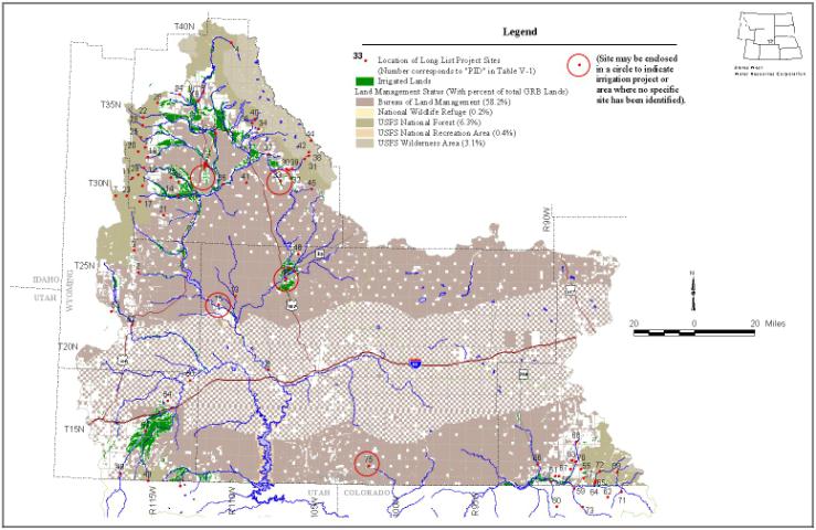
From the planning studies previously listed, and from newer potential project ideas provided by Basin Advisory Group (BAG) members, over 80 projects were reviewed for potential application to current and future needs. Items such as groundwater use and conservation are not evaluated in the long list but do show up in the short list to follow.
Screening of the initial list resulted in the removal of certain projects from further consideration. Examples of these include most projects that exist on what now are dedicated Wilderness lands. While Wilderness boundaries have been known to be moved to allow project construction, such an action is singularly rare and in most cases creates a fatal flaw for that feature. The one project involving Wilderness boundary issues that made it past the initial cut was the BAG-suggested project involving the enlargement of Green River Lakes. This project was kept alive in the process for several reasons, notwithstanding the fact that the Wilderness issue could render it unbuildable: first, its location could serve many users currently experiencing agricultural shortages; second, review of earlier studies did not indicate that it had been studied in depth as yet; and finally, while there are obvious environmental impacts associated with construction of the project, the benefits associated with augmented late season flows have not been evaluated.
Another example of a previous project that did not pass initial muster is the oft-discussed Sandstone Dam in the Little Snake River Basin. The subject of considerable study in the 1980s, this project has been effectively replaced with the imminent construction of High Savery Dam in the same drainage.
From the long list, projects of minimal size were also deleted. Generally, if a project stored or depleted 1000 acre-feet or less, it was not considered further. This decision is not intended to reflect on the importance of small projects or to diminish their need. Instead, it is simply a matter of keeping the planning process from becoming unwieldy having to consider a multitude of smaller projects. If previous studies indicated a project to be uneconomical or undesirable, this also served as impetus to delete the project from short list consideration. Projects appearing in very early studies that no longer are attractive due to location, benefits, or because other nearby sites have garnered recent favorability have also been deleted.
The long list is shown in Table V-1. A map showing the locations of these features is given as Figure V-1. Because the forecasted need for agricultural water (Chapter IV) describes a maximum of 50,000 acre-feet of storage development, no grand schemes involving multiple reservoirs are put forth. Instead, individual projects are evaluated on their own merits, and combinations thereof can be evaluated in further level I or level II studies at the pleasure of project sponsors. Where projects have been evaluated in combination by previous authors, such combinations are described in the technical memorandum on screening criteria.
Table V-1 Long List of Potential Reservoir Sites
| PID** | NAME | SIZE (AF) | SOURCE | SECTION | TOWNSHIP | RANGE | USE |
| 1 | Fish Creek | 1,400 | Fish Creek | 26 | 30 | 115 | irr |
| 2 | Fontenelle No. 1 | 2,500 | Fontenelle Creek | 4 | 24 | 115 | irr |
| 3 | Fontenelle Creek | 15,950 | Fontenelle Creek | 30 | 26 | 115 | irr |
| 4 | Green River Lakes Enl. | 250,000 | Green River | 2 | 39 | 109 | irr, pow |
| 5 | Green River Supplemental Supply Project | Canal Enlargement Only | Green River | 4 | 33 | 110 | irr |
| 6 | Kendall | 100,000 | Green River | 33 | 36 | 111 | ind, mun, irr |
| 7 | LaBarge Meadows | 4,800 | LaBarge Creek | 8 | 29 | 116 | irr |
| 8 | Lower Green Reservoir | 450,000 | Green River | 25 | 19 | 108 | irr |
| 9 | Lower Kendall | 100,000 | Green River | 4 | 35 | 111 | irr, rec, wl, pow |
| 10 | McNinch Wash | 5,600 | North Piney Creek | 10 | 30 | 113 | irr |
| 11 | Middle Piney Lake | 4,200 | Middle Piney Creek | 8 | 30 | 115 | irr |
| 12 | North Piney Cr | 5,600 | North Piney Creek | 24 | 31 | 115 | irr |
| 13 | Plains Reservoir | 480,000 | Green River | 8 | 23 | 109 | irr, ind, mun, wl |
| 14 | Sand Hill | 14,100 | Middle Piney Creek | 36 | 30 | 113 | irr |
| 15 | Seedskadee Project | 57,000 ac | Green River | 23 | 111 | irr | |
| 16 | Sixty-Seven Enl. | 5,600 | North Piney Creek | 17 | 30 | 112 | irr |
| 17 | Snider Basin | 4,300 | South Piney Creek | 11 | 29 | 115 | irr |
| 18 | South Cottonwood | 6,000 | Cottonwood Creek | 12 | 32 | 115 | irr |
| 19 | Warren Bridge Res | 33,400 | Green River | 4 | 35 | 111 | irr |
| 20 | Cottonwood No.1* | 1,465 | S Cottonwood Cr | 16 | 32 | 115 | irr |
| 21 | Fogarty Creek* | 700 | Dry Piney Creek | 24 | 28 | 114 | irr |
| 22 | Horse Creek* | 36,660 | Horse Creek | 7 | 34 | 114 | irr |
| 23 | LaBarge Reservoir* | 4,030 | LaBarge Creek | 12 | 29 | 116 | irr |
| 24 | Middle Beaver Creek* | 5,905 | Middle Beaver Creek | 29 | 36 | 112 | irr |
| 25 | North Cottonwood Creek* | 10,805 | North Cottonwood Creek | 24 | 33 | 115 | irr |
| 26 | South Beaver Creek* | 5,905 | South Beaver Creek | 24 | 35 | 114 | irr |
| 27 | South Cottonwood Creek* | 10,805 | South Cottonwood Creek | 11 | 32 | 115 | irr |
| 28 | South Horse Creek* | 36,660 | South Horse Creek | 30 | 34 | 114 | irr |
| 29 | Straight Creek* | 4,815 | Straight Creek | 4 | 30 | 115 | irr |
| 30 | East Fork | 2,100 | East Fork River | 10 | 31 | 106 | irr |
| 31 | East Fork #1 | 4,735 | East Fork River | 4 | 31 | 105 | irr |
| 32 | East Fork Gorge | unknown | East Fork River | 12 | 31 | 106 | irr |
| 33 | East Side Project | 22,000 ac | East Fork River | 30 | 106 | irr | |
| 34 | Burnt Lake | 15,570 | Fall Creek | 31 | 34 | 107 | irr |
| 35 | Halfmoon Enl. | 95,000 | Pole Creek | 15 | 34 | 108 | irr, pow |
| 36 | New Fork Narrows | 100,000 | New Fork River | 14 | 30 | 110 | irr, wl, rec |
| 37 | Silver Creek | 17,740 | Silver Creek | 11 | 32 | 107 | irr |
| 38 | Dad's Lake* | 740 | Dad's Creek | 18 | 32 | 104 | irr |
| 39 | East Fork River* | 46,070 | East Fork River | 7 | 31 | 105 | irr |
| 40 | Feltner* | 1,280 | Pole Creek | 12 | 34 | 108 | irr |
| 41 | Mack No. 1* | 766 | Skeleton Draw | 5 | 30 | 108 | irr |
| 42 | Marm's Lake* | 562 | Dad's Creek | 7 | 32 | 104 | irr |
| 43 | New Fork Lake Enl.* | 45,937 | New Fork River | 15 | 36 | 110 | irr, pow |
| 44 | Pyramid* | 636 | Pyramid Creek | 17 | 33 | 104 | irr |
| 45 | Eden No. 2 (Sander's Ranch) | 60,000 | Big Sandy Creek | 17 | 30 | 104 | irr, ind |
| 46 | Eden Reservoir Rehabilitation | 6,300 | Little Sandy River | 17 | 26 | 105 | irr |
| 47 | Eden Valley Improvements | 3,100 ac | East Fork/Big Sandy | 25 | 106 | irr | |
| 48 | Meeks Cabin Dam Enl. | unknown | Blacks Fork | 11 | 12 | 117 | irr |
| 49 | Stateline Enl. | unknown | E Smiths Fork Cr | Utah | irr | ||
| 50 | BB* | 650 | Blacks Fork | 18 | 18 | 112 | irr |
| 51 | Deer Lake* | 1,000 | E Smiths Fork Cr | 29 | 13 | 115 | irr |
| 52 | Hams Fork* | 215,475 | Hams Fork | 12 | 21 | 116 | irr, mun, ind |
| 53 | McWinn* | 800 | Hertley Hollow Cr | 16 | 22 | 117 | irr |
| 54 | Uinta Canal No. 3* | 16,790 | Uinta Can. Blacks Fk | 34 | 17 | 114 | irr |
| 55 | Big Gulch | 10,000 | Big Gulch | 19 | 13 | 88 | irr |
| 56 | Dutch Joe Creek | 14,000 | Dutch Joe Creek | 35 | 13 | 90 | irr |
| 57 | Grieve Res. | 4,860 | Grieve Res. | 5 | 12 | 88 | irr |
| 58 | Lower Willow Creek, WY | 7,000 | Lower Willow Creek, WY | 8 | 12 | 90 | irr |
| 59 | Pot Hook, CO | 20,000 | Pot Hook, CO | Colorado | irr | ||
| 60 | Upper Willow Creek, CO | 10,000 | Upper Willow Creek, CO | Colorado | irr | ||
| 61 | Cottonwood Creek* | 2,500 | Cottonwood Creek | 34 | 13 | 90 | irr |
| 62 | East Willow* | 12,000 | East Willow, CO | Colorado | irr | ||
| 63 | Loco Creek* | 3,000 | Loco Creek | 34 | 14 | 89 | irr |
| 64 | Lower Battle Creek* | 20,000 | Lower Battle Creek | 13 | 12 | 88 | irr |
| 65 | Middle Battle Creek* | 20,000 | Middle Battle Creek | 7 | 12 | 87 | irr |
| 66 | Muddy Creek* | 12,000 | Muddy Creek | 9 | 13 | 91 | irr |
| 67 | Negro Creek* | 1,000 | Negro Creek | 16 | 13 | 89 | irr |
| 68 | Old Upper Savery Cr* | 20,000 | Old Upper Savery Cr | 36 | 15 | 89 | irr |
| 69 | Roaring Fork* | 5,000 | Roaring Fork | 28 | 13 | 86 | irr |
| 70 | Sandstone* | 20,000 | Sandstone | 2 | 13 | 89 | irr |
| 71 | South Fork Little Snake* | 17,000 | South Fork Little Snake, CO | Colorado | irr | ||
| 72 | Upper Battle Creek* | 20,000 | Upper Battle Creek | 20 | 13 | 87 | irr |
| 73 | Upper Slater* | 20,000 | Upper Slater, CO | Colorado | irr | ||
| 74 | Big Basin Antelope* | 107,680 | Henrys Fork | Utah | irr | ||
| 75 | Vermilion/Red Creek Basin | unknown | Vermilion/Red Creek | 19 | 13 | 101 | irr |
Based upon comments received during Basin Advisory Group (BAG) meetings, review of previously published criteria and questionnaire results, and the Scope of Services, the following procedure for screening opportunities for future water use was developed:
| Priority | Description |
| 1 | Rehabilitation projects that preserve existing uses and economic dependencies. |
| 2 | Projects that rectify existing demands/needs/shortages. |
| 3 | Projects that meet projected future demands/needs/shortages |
| 4 | Trans-basin diversions of water that enhance in-state uses. |
Six criteria will be evaluated under each of these priorities to present an overall picture of the favorability of a project or opportunity. These criteria, and the method by which they will be applied, are:
1 Water Availability This criteria reflects the general ability of a project to function, given likely bypasses for environmental uses and prior rights. It is not a reflection of the relative size of the project. 2 Financial Feasibility This criteria reflects the effects of the combination of technical feasibility (high or low construction cost) and economic use to which the water would be put (e.g. irrigation of native meadow vs. cultivation of alfalfa or row crops). The intent of this ranking is to indicate the likely ability to afford the project or meet Wyoming Water Development Commission (or other) funding source criteria. A low number represents a project with suspect ability to be repaid, whereas a high number represents a project that should more easily meet funding and repayment requirements. 3 Public Acceptance This criteria reflects the extent to which a project will encounter or create public controversy (low number) versus a project that would likely engender broad public support (high number). For example, on-stream storage in environmentally sensitive areas would be very controversial, while off-channel storage in less sensitive areas would more likely be supported. 4 Number of sponsors/beneficiaries/participants This criteria reflects the desirability, all other things being equal, that a project serving a larger segment of the population should rank higher (higher number) than one serving only a few (lower number). 5 Legal/Institutional concerns This criteria reflects the perceived relative ease (high number) or difficulty (low number) with which a project could be authorized and permitted under existing state and federal law. 6 Environmental/Recreation benefits This criteria reflects the net effect of positive environmental and recreational aspects of a project as offset, to the extent it can be determined, by potential negative impacts on these attributes.
The planning project technical memorandum Criteria For Screening Future Water Use Opportunities contains descriptions of all projects considered in the first cut. Applying the criteria described above to those that remained resulted in the matrix shown on Table V-2. The projects listed in Table V-2 are the short list of water supply opportunities. Because many projects have different types of information available and many were studied in varying depth of detail, the process of ranking using these criteria was admittedly subjective. In many cases, the number of beneficiaries or the precise recreational and environmental benefits could not be known with certainty absent further study. As much as possible, ranking was performed based on experience with other recent projects, knowledge of basin conditions, and with the input of BAG members.
Some discussion of the scoring system used in Table V-2 is warranted. First, the scores in and of themselves are meaningless other than to place the projects in some relative order. The resulting ranking, with higher scores placing projects higher within their respective priorities, represents the relative likelihood that a project is desirable, functional and could receive enough public support to be constructed. Projects with similar "scores" but under different priorities should not be considered equally desirable or equally likely, because the weighting factors for each criteria differ depending on the priority. Potential projects are grouped by sub-basin so that plan readers can review the studied projects by geographic locale.
Conservation Opportunities
Improved irrigation practices, such as conversion from flood irrigation to sprinkler irrigation, is one means of improving the efficiency of water usage. Conveyance losses are another major factor contributing to inefficiency in agricultural use. Many ditches and canals in the Basin experience higher than normal conveyance losses, generally due to porous soils. Lining the canal with concrete or other material can greatly reduce the amount of flow lost to the surrounding soils.
Losses of 10 percent in irrigation ditches and canals are considered normal, or typical. Ditches and canals in sandy, cobbled, or alluvial soils, or fractured rock, where losses exceed 10 percent are potential candidates for rehabilitation. There are a number of canals in the Basin that exceed even 20 percent losses (see technical memorandum Water Conservation). These fall under the category of "Miscellaneous Canal Rehabilitation" in the short list of water supply opportunities.
Table V-2 Criteria Matrix
| Priority Type | PID | Est. Yield(y), Cap(c) or Depl(d) (AF) | Water Availability | Financial Feasibility | Public Acceptance | No. of Sponsors / Beneficiaries | Legal / Institutional | Environmental / Recreation Benefits | Score* ** |
| Priority 1* | 3 | 9 | 3 | 9 | 5 | 5 | |||
| Eden Reservoir Rehabilitation** | 46 | 6,300 c | 6 | 9 | 9 | 8 | 8 | 2 | 248 |
| Misc. Canal Rehab (Conservation) | unk | 9 | 7 | 8 | 6 | 6 | 2 | 208 | |
| Middle Piney Reservoir | 11 | 4,201 c | 8 | 5 | 5 | 5 | 3 | 4 | 164 |
| Sixty Seven Enlargement (off ch) | 16 | 5,600 c | 5 | 5 | 6 | 4 | 6 | 2 | 154 |
| Grieve Reservoir | 57 | 4,860 y | 4 | 4 | 6 | 4 | 6 | 4 | 152 |
| Priority 2 | 8 | 5 | 8 | 6 | 10 | 3 | |||
| Upper Green River | |||||||||
| Green River Supplemental Supply | 5 | 22,000 d | 7 | 6 | 6 | 8 | 5 | 2 | 238 |
| Sand Hill (off ch) | 14 | 14,100 c | 5 | 6 | 7 | 6 | 6 | 3 | 231 |
| Fontenelle Creek Narrows | 2 | 2,500 c | 6 | 5 | 6 | 4 | 6 | 5 | 220 |
| McNinch Wash (off ch) | 10 | 5,600 c | 5 | 5 | 7 | 4 | 6 | 3 | 214 |
| Snider Basin | 17 | 4,300 c | 6 | 6 | 5 | 5 | 5 | 5 | 213 |
| South Cottonwood | 18 | 6,000 c | 6 | 5 | 5 | 5 | 5 | 5 | 208 |
| Groundwater Development | unk | 2 | 2 | 9 | 2 | 9 | 2 | 206 | |
| North Piney Creek | 12 | 5,600 c | 6 | 2 | 5 | 5 | 5 | 5 | 193 |
| LaBarge Meadows | 7 | 4,800 c | 5 | 3 | 5 | 4 | 5 | 5 | 184 |
| Warren Bridge | 19 | 33,400 c | 8 | 5 | 2 | 8 | 1 | 4 | 175 |
| Fish Creek | 1 | 1,400 c | 3 | 5 | 5 | 2 | 5 | 4 | 163 |
| Green River Lakes Enl. | 4 | <250,000 c | 9 | 5 | 0 | 9 | 0 | 2 | 157 |
| New Fork River | |||||||||
| East Fork | 30 | 2,100 c | 7 | 5 | 5 | 5 | 5 | 5 | 216 |
| East Fork Gorge | 32 | unk | 7 | 5 | 5 | 5 | 5 | 5 | 216 |
| Boulder Lake Enl. | <120,000 c | 8 | 7 | 4 | 6 | 3 | 5 | 212 | |
| Groundwater Development | unk | 2 | 2 | 9 | 2 | 9 | 2 | 206 | |
| Silver/Spring Creeks | 37 | 17,000 c | 5 | 5 | 5 | 4 | 5 | 5 | 194 |
| Burnt Lake Enl. | 34 | 15,570 c | 8 | 7 | 2 | 5 | 2 | 5 | 180 |
| Halfmoon Enl. | 35 | <95,000 c | 8 | 7 | 2 | 5 | 2 | 5 | 180 |
| East Fork No. 1 | 31 | 4,700 c | 8 | 3 | 2 | 5 | 2 | 5 | 160 |
| Big Sandy River | |||||||||
| Sander's Ranch (Leckie Ranch) | 45 | 60,000+ c | 7 | 5 | 5 | 6 | 5 | 5 | 222 |
| Groundwater Development | unk | 2 | 3 | 9 | 2 | 9 | 2 | 211 | |
| Blacks Fork River | |||||||||
| Groundwater Development | unk | 2 | 2 | 9 | 2 | 9 | 2 | 206 | |
| Little Snake River | |||||||||
| Groundwater Development | unk | 2 | 2 | 9 | 2 | 9 | 2 | 206 | |
| Lower Willow Creek | 58 | 2,700 y | 5 | 5 | 5 | 5 | 4 | 5 | 190 |
| Big Gulch | 55 | 5,250 y | 3 | 6 | 5 | 4 | 5 | 5 | 183 |
| Upper Willow Creek (CO) | 60 | 1,500 y | 4 | 5 | 5 | 4 | 4 | 5 | 176 |
| Pot Hook | 59 | 6,700 y | 6 | 4 | 4 | 6 | 1 | 5 | 161 |
| Dutch Joe | 56 | 5,000 y | 4 | 6 | 5 | 5 | 2 | 3 | 161 |
| Vermilion/Red Creek Basins | |||||||||
| Groundwater Development | unk | 2 | 2 | 9 | 2 | 9 | 2 | 206 | |
| Storage Project | 75 | unk | 5 | 4 | 7 | 3 | 5 | 4 | 196 |
| Priority 3 | 8 | 5 | 8 | 6 | 10 | 3 | |||
| Green Below Fontenelle | |||||||||
| Groundwater Development | unk | 2 | 2 | 9 | 2 | 9 | 2 | 206 | |
| Eden Project Improvements (USBR) | 47 | 10,000 d | 6 | 5 | 6 | 6 | 2 | 2 | 183 |
| Seedskadee Project (USBR) | 86,000 d | 9 | 3 | 4 | 5 | 1 | 2 | 165 | |
| Upper Green River | |||||||||
| Green River Supplemental Supply | 5 | 22,000 d | 6 | 6 | 6 | 8 | 5 | 2 | 230 |
| Groundwater Development | unk | 2 | 2 | 9 | 2 | 9 | 2 | 206 | |
| East Side Project | 33 | 32,000 d | 6 | 5 | 4 | 4 | 3 | 3 | 168 |
| Kendall (Upper Kendall) | 6 | >100,000 c | 9 | 5 | 1 | 8 | 0 | 4 | 165 |
| Lower Kendall | 9 | >100,000 c | 9 | 5 | 1 | 8 | 0 | 4 | 165 |
| New Fork Narrows | 36 | >100,000 c | 9 | 4 | 1 | 5 | 0 | 4 | 142 |
| Blacks Fork / Hams Fork Rivers | |||||||||
| Viva Naughton Enlargement | 36,000 c | 7 | 5 | 6 | 5 | 5 | 6 | 227 | |
| Stateline Enlargement | 49 | unk | 6 | 5 | 6 | 7 | 4 | 5 | 218 |
| Meek's Cabin Enlargement | 48 | unk | 5 | 5 | 6 | 7 | 4 | 5 | 210 |
| Groundwater Development | unk | 2 | 2 | 9 | 2 | 9 | 2 | 206 | |
| Little Snake River | |||||||||
| Groundwater Development | unk | 2 | 2 | 9 | 2 | 9 | 2 | 206 | |
| Lower Willow Creek | 58 | 2,700 y | 5 | 5 | 5 | 5 | 4 | 5 | 190 |
| Upper Willow Creek (CO) | 60 | 1,500 y | 4 | 5 | 5 | 4 | 4 | 5 | 176 |
| Dolan Mesa Canal | 2,700 d | 5 | 3 | 5 | 3 | 4 | 4 | 165 | |
| Savery-Pot Hook Project(USBR) | 5,000 y | 6 | 4 | 4 | 6 | 1 | 5 | 161 | |
| Priority 4 | 3 | 5 | 10 | 6 | 9 | 5 | |||
| Green Below Fontenelle | |||||||||
| Plains Reservoir (off ch) | 13 | <480,000 c | 9 | 3 | 3 | 3 | 1 | 4 | 89 |
| Lower Green Reservoir | 8 | <450,000 c | 9 | 2 | 2 | 2 | 1 | 3 | 73 |
| Upper Green River | |||||||||
| Kendall (Upper Kendall) | 6 | >100,000 c | 9 | 4 | 0 | 7 | 0 | 3 | 104 |
| Lower Kendall | 9 | >100,000 c | 9 | 3 | 0 | 5 | 0 | 3 | 87 |
| New Fork Narrows | 36 | >100,000 c | 9 | 3 | 0 | 5 | 0 | 3 | 87 |
In recent years, federal and state laws, rules, regulations and policies have affected the business of water development and management. The purpose of this section is to identify some of these institutional constraints to water development and to discuss some steps that a project proponent may take to address those constraints.
Federal Environmental Laws
In the late 1960's and early 1970's, Congress passed legislation to protect the environment. Prior to the passage of these laws, most water projects were designed and operated for specific consumptive uses for municipal, agricultural or industrial purposes. Environmental benefits derived from the projects were largely indirect and incidental to the purposes for which they were designed. With the passage of environmental laws, minimum flow releases became requirements of federal project permits. At the same time, the economic benefits of recreation and reservoir fisheries became more apparent, which resulted in minimum pools becoming a planned component of reservoir operations.
Actions relating to water supplies and development that might be requested of the federal government that initiate or "trigger" the federal environmental laws include, but are not necessarily limited to, the following:
The only water development activity that presently falls outside the aegis of federal environmental laws is drilling a well with non-federal funds on non-federal lands outside the banks of rivers, streams, and wetlands. However, piping the water from such wells across federal lands or rivers, streams, and wetlands could initiate a federal environmental review.
Endangered Species Act
The Endangered Species Act of 1973 (ESA) requires the Secretary of Interior, through the U.S. Fish and Wildlife Service (USFWS), to determine whether wildlife and plant species are endangered or threatened based on the best available scientific information. The ESA constrains all federal agencies from taking any action that may jeopardize the continued existence of an endangered or threatened species. If a federal agency is considering an action that may jeopardize an endangered species, Section 7 of the ESA requires that the agency must consult with the USFWS.
National Environmental Policy Act
The National Environmental Policy Act of 1969 (NEPA) requires that federal agencies consider all reasonably foreseeable environmental consequences of their proposed actions. A review of that action under NEPA can be in the form of a simple finding of no significant impact (FONSI), an environmental assessment (EA), or an environmental impact statement (EIS). Further, NEPA requires federal decision makers to "study, develop, and describe appropriate alternatives to recommended courses of action in any proposal which involves unresolved conflicts concerning alternative uses of available resources." (42 USC 4321 et seq., Sec. 102(2)E). NEPA provides federal agencies the opportunity to determine which alternative, including no action, they feel best serves the applicant's purpose and need. The alternative selected by the federal agency may differ from the one preferred by the applicant.
Clean Water Act
Section 404 of the Clean Water Act of 1972 prohibits discharging dredged or fill materials into waters of the United States without a permit from the U.S. Army Corps of Engineers (USCOE). The waters of the United States include rivers and streams and, as of 1993, wetlands. USCOE policy requires applicants for 404 permits to avoid impacts to waters of the U.S. to the extent practicable, then minimize the remaining impacts, and finally, take measures to mitigate unavoidable impacts. In addition to the alternative review required by NEPA, Section 404 (b)(1) guidelines require an alternative review to define the least environmentally damaging practicable alternative.
Summary
The federal government, with the authorizations provided by the Endangered Species Act, the National Environmental Policy Act, and the Clean Water Act, has the tools to ensure the protection of endangered species, critical habitat, and other federal environmental interests.
Federal Lands
Approximately 68 percent of the Green River Basin is federal land. In particular, the Bureau of Land Management (BLM) administers about 58 percent, over 6 percent are national forests, while recreation areas, wilderness areas, and wildlife refuges combined comprise just under 4 percent. Moreover, there are candidate lands for wild and scenic designations. The BLM, the U.S. Forest Service, or others agencies managing the federal lands must assure that the requirements of the above laws are met before they can issue a special use permit authorizing a proposed action on federal lands, such as construction of a water project.
The scrutiny under which the federal laws will be applied is based on the sensitivity of the environment impacted or effected. For example, it may be a rather simple process to obtain a special use permit to construct a small water pipeline across the prairie within BLM jurisdiction. However, it would be virtually impossible to obtain a special use permit to construct a large dam within a wild and scenic river designation.
Project proponents must demonstrate a "purpose and need" for a project in order to obtain federal clearances for major water projects, whether or not the proposed project is located on federal lands. However, if the proposed location of the project is on federal lands, the "purpose and need" of the project proponent may be secondary to goals of the federal agency's management plans. Providing supplemental irrigation water has been recognized as sufficient purpose and need to justify a project.
As previously noted, NEPA provides federal agencies the opportunity to determine which alternative, including no action, they feel best serves the applicant's purpose and need. If the proposed project is located on federal lands and does not comply with the federal agency's management plan, project proponents may be faced with the task of convincing that federal agency that the proposed project at that specific location is the only alternative available to meet the proponent's purpose and need.
Wyoming Environmental Laws
The Section 401 Permit is the state certification of the Section 404 Dredge and Fill Permits required from the U.S. Army Corps of Engineers. A separate permit application is not required since all 404 Permit applications are automatically forwarded to the state in which a the 404 permit is being requested. The Section 401 permit also outlines those additional permits required prior to the initiation of construction activities.
Wyoming Water Law
Wyoming water law is based on the prior appropriation doctrine, or "first in time-first in right". Therefore, in times when there is not enough water to fulfill all the water rights, those water users having an earlier-priority-date water right are allowed to receive their full entitlement before those water users that have a later priority date or "junior" water right may receive any water under their right.
The priority date for a new project is established by the date the project proponent applies for a water right from the Wyoming State Engineer's Office. In order to determine the water supply a new project may achieve, it is important to evaluate the existing water rights that will be "senior" to the new project. Before the decision is made to pursue a project at a particular location, the potential yield of the project should be estimated. The firm yield is the water supply benefits the project proponent could expect under worst case or drought conditions. If the proposed project is located on a stream or river that has several "senior" water rights, a new project may not be able to achieve a water supply in the drier months, such as July and August, or during drought years. Under these conditions, the development of storage facilities would be required to store water when flows are surplus to existing water rights.
Due to the costs involved, water users are naturally interested in a firm supply before they are willing to invest in a water project. In fact, industrial water users are interested in the yield of a potential project under "doomsday" conditions, such as assuming that the worst water year of record occurs in consecutive years. These expectations of water users make the priority date of the water rights of new projects relative to existing water rights a critical factor in assessing the feasibility of new water development projects.
The following is a list of actions project proponents may take to address the institutional constraints within federal and state laws, rules, regulations and policies.
Project Purpose
Project proponents should have a clear definition of the purpose of their project. There are several purposes for a project: agricultural, municipal, or industrial water use; power generation; flow control; recreation; fisheries and others. In fact, the project proponent may have several purposes in mind. For example, a reservoir could serve all of the above listed purposes. However, the alternatives analyses required by NEPA can become very complex, time consuming and costly for a multipurpose project. Each of the purposes for a proposed project will typically have its own individual alternative analysis.
Project Need
The project proponent must define the need for water to meet the defined purpose or purposes for the project. For example, if the purpose of a proposed agricultural project is to increase the yield of alfalfa or native hay, the amount of water needed for this purpose must be calculated. If the purpose of a proposed municipal project is to meet future water needs, the project proponent must complete population projections and future demand estimates in a manner that withstands the scrutiny of the federal permitting agencies. The needs analyses will have to quantify the amount of water that will be stored or diverted and consumed by the proposed action. Typically, the federal permitting agencies will require that future water conservation activities be considered in the needs analysis.
Alternative Analyses
Project proponents should have evaluated several alternatives prior to selecting the alternative that is going to be subjected to the federal review process. As previously noted, NEPA regulations require that the "no action" alternative be considered; all reasonable alternatives should be considered; and the reasons for eliminating potential alternatives must be provided. Therefore, project proponents should develop sufficient information for alternatives to evaluate how well the preferred alternative will fare under the federal review. The federal agencies will typically require that water conservation must be considered as an alternative to the project.
Selection of the Preferred Alternative
Cost and technical feasibility are the primary factors considered by project proponents in determining project feasibility. While these factors are also considered by federal permitting agencies, the federal perspective is more interested in the environmental damage that may occur if the project is constructed and implemented. Therefore, project proponents should consider potential environmental impacts in developing project alternatives.
Federal Lands
If possible, project proponents should avoid locating their project on national forests. It is virtually impossible to locate new water projects within wilderness areas, wildlife refuges, and wild and scenic designations.
Wyoming Water Development Program
Planning, constructing, and operating a water project is costly. Adding the costs to acquire state and federal permits can be overwhelming for public entities in Wyoming. In 1975, in recognition that water development was becoming more difficult and additional water development was necessary to meet the goals and objectives of the State, the Wyoming Legislature authorized the Wyoming Water Development Program and defined the program in W.S. 41-2-112(a), which states:
"The Wyoming water development program is established to foster, promote, and encourage the optimal development of the State's human, industrial, mineral, agricultural, water and recreation resources. The program shall provide through the commission, procedures and policies for the planning, selection, financing, construction, acquisition and operation of projects and facilities for the conservation, storage, distribution and use of water, necessary in the public interest to develop and preserve Wyoming's water and related land resources. The program shall encourage development of water facilities for irrigation, for reduction of flood damage, for abatement of pollution, for preservation and development of fish and wildlife resources [and] for protection and improvement of public lands and shall help make available the water of this State for all beneficial uses, including but not limited to municipal, domestic, agricultural, industrial, instream flows, hydroelectric power and recreational purposes, conservation of land resources and protection of the health, safety and general welfare of the people of the State of Wyoming."
The Wyoming Water Development Commission can invest in water projects as state investments or can provide loans and grants to public entities (municipalities, irrigation districts and special districts) for the construction of projects specific to their water needs. The WWDC has adopted operating criteria to serve as "a general framework for the development of program/project recommendations and generation of information." Individuals and project entities interested in the development of specific water projects should seek information regarding the Wyoming Water Development Program and the possibility of obtaining financial and technical assistance for the development of those projects.
Upper Colorado River Recovery Implementation Program
The State of Wyoming has historically been proactive in dealing with institutional constraints that may impact its ability to develop its water resources as allocated by court decrees and interstate compacts. State representatives review proposed federal mandates ranging from new federal environmental legislation to forest management plans to interject the State's position on these matters and provide for a state perspective in their development and implementation.
One example deals directly with water development in the Green River Basin and the institutional constraints contained in the Endangered Species Act (ESA). In 1988, the States of Wyoming, Utah, and Colorado; the Department of the Interior; and the Western Area Power Administration executed a cooperative agreement to recover four endangered fish species in the Upper Colorado River Basin, while allowing water development to continue. Wyoming's participation in this Upper Colorado River Recovery Implementation Program has facilitated the process by which Wyoming water projects obtain federal clearances under ESA. Rather than spending thousands of dollars on evaluations of potential impacts to the fish species and developing expensive mitigation plans, a project proponent may be able to pay a one-time charge for new depletions which is paid into a fund to benefit the endangered fish. The one-time charge is approximately $14 per acre-foot of depletions, adjusted annually for inflation.