| ||||||||||

| Home Page News & Information River Basin Plans Basin Advisory Groups Planning Products |
TECHNICAL MEMORANDUM
This Technical Memorandum discusses Tribal Futures Projects and expansion of irrigated agriculture within the Wind/Bighorn River Basin Plan. The document fulfills a portion of the reporting requirements of Task 4 from the original contract. This technical memorandum contains the following sections. Within each section are tables and figures containing the data for each of the main study area basins.
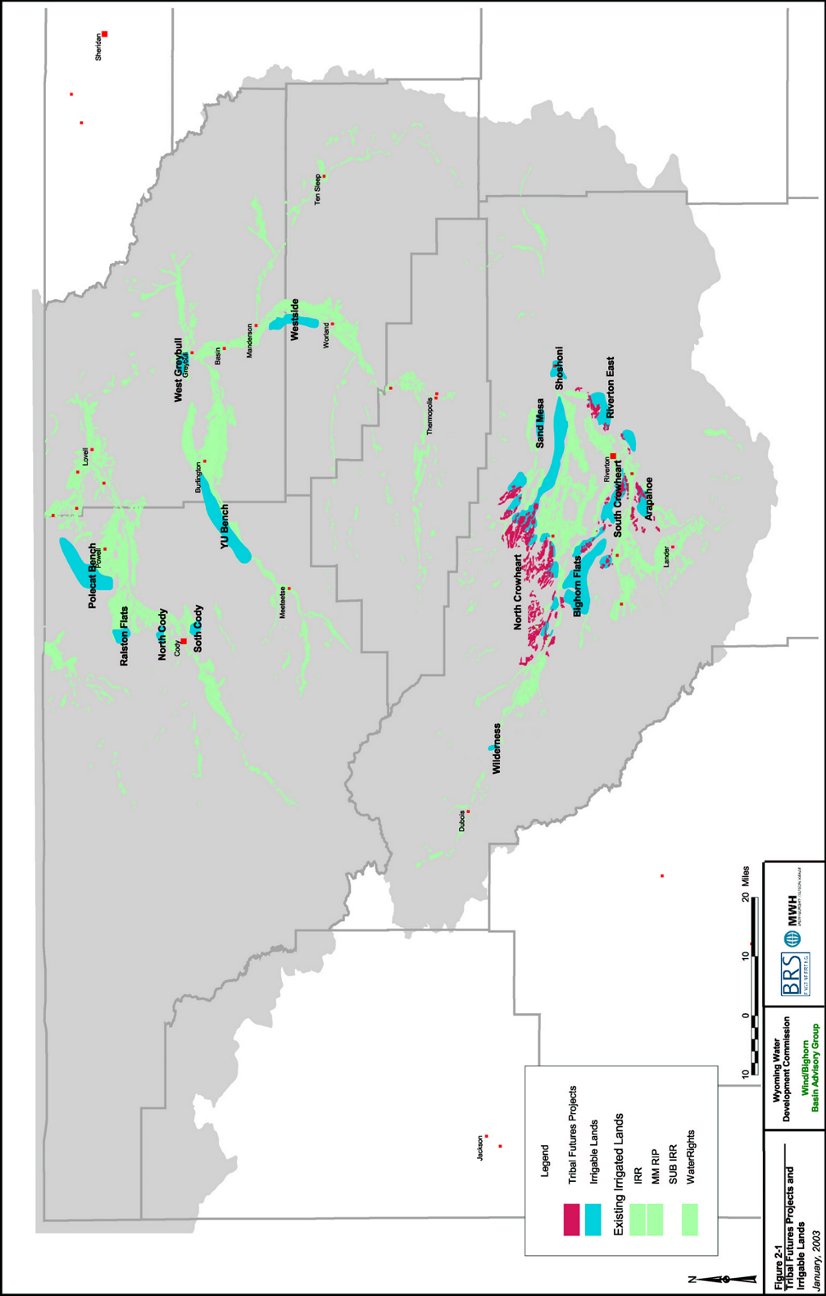
Section 1 - Introduction Irrigated agriculture is the largest consumer of water within the Wind/Bighorn Basin. However, as discussed in the Task 3D Technical Memorandum, Available Surface Water Determination (Wind/Big Horn Basin Plan, 2003), there remains on average over 1,500,000 acre-feet of water available in the Bighorn basin and nearly 450,000 acre-feet of water available in the Clarks Fork basin. As described in other technical memorandums within Task 5, there are many potential uses for this excess water, and expansion of irrigated agriculture within the basin ranks among the highest priority uses. In fact, several studies, including the Potentially Irrigable Acres (PIA) study which was developed for the adjudication of Tribal Reserved Water Rights, have studied the economics of additional agriculture within the basin and found it to be cost effective. The purpose of this technical memorandum is to identify potential future uses of water within the basin by irrigated agriculture. This includes the potential development of projects both on and off of the Wind River Reservation, and with both senior Tribal Reserved Water Rights, more junior water rights for currently undeveloped projects or water rights yet to be identified or quantified. Section 2 describes each of these data sets and the irrigable lands, crop irrigation requirements and diversion requirements for lands within the data sets, while Section 3 compares the diversion requirements to available flow. Several agricultural development scenarios are presented in Section 4. Section 2 - Potential Agricultural Development Two primary sources of information were reviewed to identify potential agricultural development within the Wind/Bighorn Basin Plan: the Tribal Futures Projects and a WWDC irrigable lands database. A map showing both the Tribal Futures Projects and the irrigable lands is shown in Figure 2-1. Future agricultural use must be viewed in the context of current water availability and water right priority. As discussed in the “Agricultural Water Use and Diversion Requirements” Technical Memorandum, Chapter 2, Tab 5, irrigated lands mapping and historical use date indicate that some 430,000 to 450,000 acres of land are actually irrigated in the basin in any given year. However, water rights data from the SEO shows that water rights are held for the irrigation of over 600,000 acres. The modeling of surface water availability considers various use options including historical diversions (approx. 450,000 acres), full supply based on water rights (approx. 600,000), and full supply plus tribal futures (approx. 650,000 acres). 2.1 Tribal Futures Projects As part of the Bighorn Decree (Roncolio, 1982), the Shoshone and Northern Arapahoe Tribes were awarded Federal Reserved Water Rights for not only lands with existing irrigation, but also lands that could be economically irrigated as determined through a Practicably Irrigable Acres (PIA) study. PIA studies have become the benchmark for quantification of Federal Reserved Water Rights throughout the Western United States. The PIA study is a compilation of agronomy, engineering and economic analysis that identifies currently undeveloped land that could feasibly be irrigated. The results of the PIA study were the conceptual development of 5 projects encompassing approximately 54,000 acres on the Wind River Reservation. The projects, conceptual land area and the awarded diversion requirement are shown in Table 2-1.
Table 2-1. Tribal Futures Projects Awarded and Modeled Land Area and Diversion Requirements
Figure 2-1. Tribal Futures Projects and Irrigable Lands Within the Wind/Bighorn Basin
As discussed in the Task 3B/3C Technical Memorandum, Spreadsheet Model Development and Calibration (Wind/Big Horn Basin Plan, 2003) and the Task 3D Technical Memorandum, Available Surface Water Determination (Wind/Big Horn Basin Plan, 2003), the Tribal Futures Projects were included in modeling runs to determine their general affect on streamflows and other diversions within the basins. The data included in the model for the Futures projects was developed the same as the other diversion data for the model, as described more thoroughly in the Task 2A Technical Memorandum, Agricultural Water Use and Diversion Requirements (Wind/Big Horn Basin Plan, 2003). An overall efficiency of 55 percent was utilized for those Projects where conveyance was proposed through open ditches, while an overall efficiency of 62 percent was used for conveyance through pipelines. Both of these efficiencies assume improved on-farm applications, such as gated pipe and/or sprinklers as developed in previous studies for Riverton East and the SCS (Nelson, 2001; SCS, 1992). As shown in Table 2-1, there are slight differences between the awarded and modeled acreages and diversion requirements for the Futures Projects. The information for the Wind/Bighorn River Basin plan was developed using the most current reasonable data for climate, crop water requirements and anticipated efficiencies for the Projects, thus accounting for the differences in developed values. In addition, the Wind/Bighorn River Basin model does not explicitly include the Popo Agie River basin. However, the impacts to the Popo Agie basin from diversions by the Arapahoe Project are implicitly included in the model results through an input node for the Popo Agie River basin with data supplied by the Popo Agie Watershed Plan (Anderson, 2003). The information presented in the Wind/Bighorn River basin plan regarding Futures Projects is in no way intended to infer proposed changes to the Decree, nor do they suggest administrative changes to the decree. They only reflect general estimates on how Futures projects could impact the basin. In order to simulate the effects of the Tribal Futures Projects, CIR and diversion requirements were required. A summary of the diversion CIR and diversion requirements as they related to the physical nodes in the model representing the Futures Projects are presented in Table 2-2 and Table 2-3.
Table 2-2. CIR for Tribal Futures Projects used for Modeling
Table 2-3. Diversion Requirement for Tribal Futures Projects used for Modeling
The effects of Tribal Futures Projects on flows within the basin and on other diversions within the basin are more fully described in and the Task 3D Technical Memorandum, Available Surface Water Determination (Wind/Big Horn Basin Plan, 2003). However, as stated in the Task 3D Technical Memorandum, the model limitations need to be realized. The model does not explicitly account for water rights. Because the Futures Projects would have Federal Reserved Water Rights, the impacts from the Futures Projects would be much more severe on junior water rights within the basin than the senior water rights. It should also be realized that the impacts are based on full development of the Futures Projects. The impacts of developing a portion of the Futures Projects would be less severe on the basin. A brief description of each potential Futures project within the Wind/Bighorn Basin plan study area follows. The Arapahoe Irrigation Project is discussed in the Popo Agie Watershed Study (Anderson, 2003). 2.1.1 Riverton East Irrigation Project The Riverton East project has been under consideration for several years and is one of the most likely to proceed into more immediate development. This project would bring at least 3,900 new acres under irrigation and would require at least 8,361 acre-feet of water annually. Additional storage in the Upper Wind River Basin for this project could be provided through projects such as the proposed Steamboat Reservoir or the proposed enlargement of Bull Lake. 2.1.2 North Crowheart Irrigation Project The North Crowheart irrigation project is by far the largest of the tribal futures projects and would entail up to 40,839 new acres consuming some 81,260 acre-feet of water annually. This project would require the construction of upstream storage and diversions. Sighting of potential storage and diversion structures has been studied extensively. The most recent study of the Upper Wind River Storage was funded by the WWDC (SEH, 2001) 2.1.3 South Crowheart Irrigation Project The South Crowheart irrigation project includes some 5,019 new acres of irrigation and has an annual water demand of sine 10,260 acre-feet. Storage for this project could be provided by the same projects as needed for the Riverton East project, the proposed Steamboat Reservoir or the proposed enlargement of Bull Lake. 2.1.4 Bighorn Flats Irrigation Project Big Horn Flats has three components, all would require pumping. The aggregate acreage of these areas is 2,751 acres and would consume approximately 5,000 acre-feet of water annually. 2.2 Irrigable Lands In addition to Tribal Futures projects, there are other potential agricultural development projects within the Wind/Bighorn River basin that have been discussed over the years. In 1991, the Wyoming Water Development Commission funded a study that developed an estimate of irrigable lands throughout the state (WWDC, 1991) that are not currently in production. Several locations were identified within the Wind/Bighorn River Basin. A summary of the irrigable lands is shown in Table 2-4. The annual Crop Irrigation Requirement (CIR) and Diversion Requirements shown in the table were developed similar to existing irrigated lands as discussed in the Task 2A Technical Memorandum, Agricultural Water Use and Diversion Requirements (Wind/Big Horn Basin Plan, 2003). An overall efficiency of 55 percent was utilized, which represents large canal delivery systems with improved on-farm applications, such as gated pipe and/or sprinklers, previous studies for Riverton East, and the SCS (Nelson, 2001; SCS, 1992). As shown in Table 2-4, those lands that are generally associated with the Tribal Futures Projects comprise approximately 60 percent of the irrigable lands within the basin. It is interesting to note that the Tribal Futures Projects awarded acreage is approximately 38 percent of the total lands identified as irrigable in the study. The largest non-Futures Projects irrigable land groups are the Westside Irrigation Project in the Upper Bighorn sub-basin, lands on the YU bench in the Greybull River sub-basin, and lands on the Polecat Bench in the Shoshone and Clarks Forks sub-basins. Descriptions of these three areas follow the table.
Table 2-4. Summary of Potentially Irrigable Lands with Wind/Bighorn Basin
2.2.1 Westside Irrigation Project The Westside Irrigation Project has been under consideration for several years and is one of the most likely to proceed into development. This project has advanced and will require congressional approval for the transfer of federal lands associated with this project. This project would bring some 11,690 new acres under irrigation and would require approximately 23,000 acre-feet of water annually. Although modeling indicates that surface water would be available for this project from the main-stem of the Big Horn River currently. Full utilization of the Tribal water rights and/or other priority water rights could limit future water availability. This potential could be offset by additional storage in the Upper Wind River basin. 2.2.2 YU Bench Irrigation Project Mapping of the YU bench indicates nearly 30,000 acres of land that are potentially irrigable. If this project were developed, the actual acres irrigated would be expected to be less. The YU bench is located in the Greybull drainage above the recently constructed Roach Gulch dam. The majority of the lands within the YU Bench are federal and would require a transfer of lands similar to the action necessary for the Westside Irrigation Project. The Greybull drainage does not typically have surface water available for a project of this magnitude. In order for this project to be feasible, storage would need to be constructed on the Clarks Fork drainage and water conveyed to the Greybull drainage. The annual water demand under full irrigation for the YU Bench is estimated at nearly 50,000 acre-feet. However, Wyoming has typically available some 450,000 acre-feet of water in the Clarks Fork drainage which leaves the state unused each year. 2.2.3 Polecat Bench Irrigation Project The Polecat Bench is located in the Clarks Fork and Shoshone drainages northwest of Powell, Wyoming. Land ownership is mixed between federal and private. This area comprises of approximately 28,000 acres and would require upstream storage in the Clarks Fork drainage. As with the YU Bench sufficient surface water is available in the Clarks Fork to support this project. At an elevation in excess of 5,000 feet, types of agricultural crops may be limited in this area. Crops such as alfalfa and grains, which do not require a long growing season, would be suitable for this area. Water demand would be similar to that of the YU Bench, approximately 50,000 acre-feet. Section 3 - Available Flow for Agricultural Development Available flow for all reaches within the model was calculated and is summarized in the Task 3D Technical Memorandum, Available Surface Water Determination (Wind/Big Horn Basin Plan, 2003). Using this data, diversion requirements can be compared to available surface water both annually, and by month to determine whether adequate supply exists from the primary source to fulfill the diversion requirements for the project, and whether storage is needed to store water from wetter months to drier months or from wetter years to drier years. A summary of this analysis is presented in Table 3-1.
Table 3-1. Comparison of Diversion Requirements to Available Flow for Selected Projects
As shown, several of the projects could likely be developed with no or minimal storage, including the Riverton East project, the Westside Irrigation project and the Polecat Bench project. It should be noted that although the model shows that no storage is needed for these projects, to maintain required peak diversions during the peak months, small amounts of re-regulation storage may be required within the Projects themselves. The model indicates that there is available flow in the Upper Wind River for the North Crowheart Project in dry and average years. In dry years, the Project (or other diversions in the basin with junior water rights) would be short. Therefore, multi-year carryover storage would be required. In addition, during all hydrologic years, some portion of storage would be required to store water in the spring and release later in the summer. The YU Bench is located within the Greybull River basin. As shown in the table, it is likely that there would not be enough water in the Greybull River during most years. Therefore, if the YU bench were developed, imports from other basins, either the South Fork of the Shoshone River or the Clarks Fork River, would be required. In addition to the trans-basin diversion, a storage reservoir would be required to store high flows during the spring, and inflows year-round (spring, summer and fall) so they can be released during high demand times in the late summer. Section 4 - Agricultural Development Scenarios For purposes of the Wind/Bighorn Basin plan, three scenarios have been developed to simulate potential future irrigation development within the basin planning area. These are described as follows:
A summary of each scenario, their associated irrigated lands and the annual crop irrigation requirement and diversion requirement is shown in Figure 2-1.
Table 4-1. Potential Agricultural Development Scenarios
BRS, Inc. 2003b. “Wind/Bighorn River Basin Plan Irrigation Diversion Operation and Description.” Technical Memorandum, Riverton, Wyoming. MWH. 2003. “Wind/Bighorn River Basin Plan Task 2A – Agricultural Water Use and Diversion Requirements.” Technical Memorandum. Denver, Colorado. MWH. 2002. “Wind/Bighorn River Basin Plan Task 3A/3B - Surface Water Hydrology.” Technical Memorandum. Denver, Colorado. MWH. 2003. “Wind/Bighorn River Basin Plan Task 3B/3C - Spreadsheet Model Development and Calibration.” Technical Memorandum. Denver, Colorado. Nelson Engineering. 2001. Riverton East Irrigation Project (DRAFT REPORT). Level II Feasibility Study, Wyoming Water Development Commission. Jackson, Wyoming. October. Pochop, Larry, Travis Teegarden, Greg Kerr, Ronald Delaney and Victor Hasfurther. 1992. Consumptive Use and Consumptive Irrigation Requirements in Wyoming. WWRC Publication #92-06. University of Wyoming, Laramie. October. Roncolio, Teno. 1982. Report Concerning Reserved Water Right Claims By and On Behalf of the Tribes of the Wind River Indian Reservation, Wyoming. Civil Case No. 4993, District Court of the Fifth Judicial District, State of Wyoming. December 15. Short Elliot Hendrickson Inc. (SEH). 2001b. Upper Wind River Storage Project-Level 1 Study. Final Report. Prepared for Wyoming Water Development Commission, Contract No. 05SC0291630, SEH No. AWWDC00101.00. November 30. Soil Conservation Service (SCS). 1992. Interim Irrigation On-Farm Report for Wind River Basin Water Supply Study (DRAFT). Casper, Wyoming. May. |
|||||||||