| |||||||

| Home Page News & Information River Basin Plans Basin Advisory Groups Planning Products |
WIND/BIGHORN RIVER
PREPARED FOR THE:
Acknowledgements The BRS team would like to acknowledge the assistance of several individuals, groups and agencies that contributed to the Wind/Big Horn Basin planning process.
The Wind/Big Horn River Basin Advisory Group As well as those who gave presentations to the Wind/Big Horn Basin Advisory Group.
Barry Lawrence, Wyoming Water Development Commission
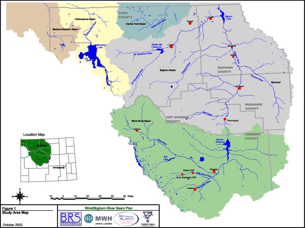
EXECUTIVE SUMMARY Authorization The Wind/Bighorn Basin (WBHB) Plan is one of a series of River Basin Plans prepared, or currently being prepared, for the Wyoming Water Development Commission (WWDC). The 2001 Wyoming Legislature authorized the Water Development Commission to complete this specific basin plan as part of the overall State Water Plan. The study area is shown on the front cover. River Basin Plans have been completed for the Bear River Basin, Green River Basin, the Northeast Wyoming River Basins and the Powder/Tongue River Basins. The Snake/Salt River Basin Plan is being completed contemporaneously with the WBHB Plan. The Platte River Basin planning process is scheduled to begin in 2003 and is the final of the basin plans. It is the intent of the WWDC that the information presented in the plan documents will be reviewed and updated every five years to reflect changes and new concerns. Project Scope The WBHB includes the Wind River, Clarks Fork of the Yellowstone and Bighorn River Basins and focuses on major water uses including agricultural, municipal, domestic, industrial, environmental and recreational, and water use from storage. Figure 1 shows the area included in the basin plan. The basin plan documents current water uses, surface and ground water availability, and projects future uses and/or demands for water based on various planning scenarios. In addition, institutional and legal constraints governing water development and management were reviewed and are summarized within this report. Based on this information, potential water development projects were identified. Subsequent to the initial scope of work, a review of power generation opportunities in the WBHB area was requested by the WWDC, including both hydropower and fossil fuel power generation. Basin Description The Wind/Bighorn Basin planning area includes all of Big Horn, Park, and Hot Springs Counties, about 95% of Washakie County, approximately 85% of Fremont County, roughly 10% of Teton County, and the over 2 million acres of the Wind River Indian Reservation. Also included, are small, relatively undeveloped portions of northwestern Natrona and western Johnson Counties. Approximately 80% of Yellowstone National Park is included in the planning area. Regionally, the planning area lies within the Missouri River drainage system and covers an area of approximately 20,500 square miles of federal, state, and privately owned land in central and northwestern Wyoming. Only 30% of the land within the planning area is privately controlled. Elevations in the planning area are variable because the Wind River and Bighorn Basins are bordered by high alpine mountain ranges. Elevations range from roughly 3,500 feet above sea level, where the Bighorn River crosses the State line into Montana in Big Horn County, to 13,804 feet at the summit of Gannett Peak in Fremont County. The climate varies primarily as a function of elevation, and ranges from semi-arid continental in the WBHB interiors to humid-alpine in the bordering mountain ranges. Annual precipitation varies from 6 to 8 inches in the WBHB interiors, up to 60 to 70 inches along the peaks of the bordering mountain ranges. Most of the planning area receives the majority of its precipitation during the winter as snowfall, but the interiors primarily receive precipitation from occasional spring and summer thunderstorms.
(Click on image for more details)Unique water-related environmental features of the WBHB include the glaciers of the Wind River mountain range, a section of the Clarks Fork of the Yellowstone is designated as a ôWild and Scenicö river, Sinkĺs Canyon, the Thermopolis Hot Springs, and the numerous natural wonders of Yellowstone Park. Basin Advisory Group Meetings (BAG) Basin Advisory Group (BAG) meetings were held every other month between May 2001 and April 2003. The meetings were structured to inform the BAG and the public of issues within the WBHB and to solicit input in the basin planning process. The BAG, comprised of a broad range of interests including various local governments, The Wind River Indian Reservation, water conservation districts and representatives from agricultural, industrial, recreational, environmental and economic interests, provided their opinions on water planning issues, planning products, and assisted in the planning process. More information on the BAG meetings can be found on the web at (http://waterplan.state.wy.us/) including the meeting records, the reference notebook, and select presentations. Compacts and Decrees Within the Wind River, Clarks Fork and Bighorn Basins, surface water usage and flow is regulated by the Yellowstone River Compact of 1950 and the GENERAL ADJUDICATION OF ALL RIGHTS TO USE WATER IN THE BIG HORN RIVER SYSTEM. The Yellowstone Compact allocates unappropriated waters (surface), after meeting existing water rights (1950) and supplemental supply for existing rights, as follows:
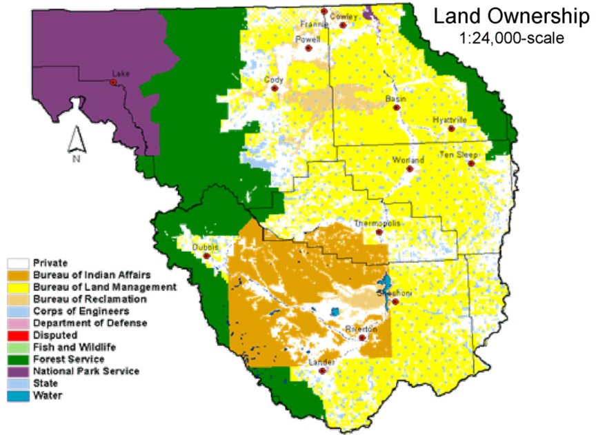
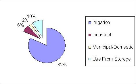
The Big Horn General Adjudication awarded the Shoshone and Arapaho tribes of the Wind River Indian Reservation (WRIR) the right to 500,000 acre feet of surface water annually with a priority date of 1868. Within this allocation some 209,000 acre feet is reserved for future project development. For ground water rights, there are no WRIR reserve water rights. Land Ownership As depicted on the cover, the WBHB includes the 1.5 million acres in the WRIR and some 14.1 million acres of land, the majority of which is publicly owned. Public lands consist of 600,000 acres of state land and 8.9 million acres of federal land, dominantly BLM and U.S. Forest Service. Current Water Use Figure 2 provides and overview of water use in the WBHB (from 2000 statistics). Water use is dominated by Agricultural use, which in turn is dominated by crop irrigation, as compared to grazing and other agricultural activities.
Figure 2 Overview of Water Use
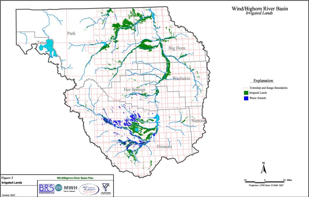
Agricultural The Wyoming State Engineerĺs Office (SEO) records for Water Division No. III show some 450,000 acres of land historically irrigated in the WBHB. Of this total, approximately 344,000 acres are reported as irrigated by the U.S. Department of Agriculture (USDA). Irrigated lands mapping, completed as part of this study, found some 560,000 acres of irrigated or potentially irrigated lands, based on 1999 aerial color infrared mapping. Water rights attribution associated with the irrigated lands mapping indicated about 600,000 acres with water rights at the time of the investigation. Finally, the proposed tribal futures projects could add approximately 53,000 acres. Given these variations, surface water use and availability was modeled to consider Historical Diversions (~450,000 acres irrigated), Full Supply (~600,000 acres irrigated), and Full Supply with Futures (~653,000 acres irrigated). Crop Irrigation Requirements (CIR) were determined based on crop type and climatic location within the WBHB. Typical crops include: alfalfa, beans, corn, other hay crops, spring grains, sugar beets, and other minor crops. Based on the CIR evaluation, the Full Supply consumptive use was estimated to be 1,165,000 acre feet per year (approximately 1.94 acre feet per acre per year). Figure 3 depicts the Irrigated Lands in the WBHB.
(Click on image for more details)Municipal and Domestic According to the U.S. Environmental Protection Agency (EPA), there are currently 58 active municipal and non-municipal community public water systems in the Wind/Big Horn Basin. These systems are capable of storing more than 36.7 million gallons of water obtained from rivers, streams, wells, reservoirs, and lakes to serve more than 59,000 people, or roughly 87% of the WBHB's population. The average daily municipal water use for the Wind/Bighorn Basin is approximately 12.2 million gallons per day (MGD), or roughly 207 gallons per day per person. Surface water is utilized to supply 68% of the average water use, with the remainder from ground water sources. Based on rural domestic and non-municipal public water system usage, total domestic water usage for the planning area has been estimated to range from 6.5 to 10.4 MGD. Almost 83% of rural domestic water supplies are derived from wells located in Fremont and Park Counties. For the 34,287 people who use the 115 non-municipal public water systems, domestic water usage is estimated at 2.57 MGD. Both ground and surface water supplies are utilized to meet daily domestic demand. Within the WBHB, roughly 26% of the domestic use is supplied by surface water sources, while 74% is supplied by ground water. Industrial and Mining Most industrial water users in the WBHB are comparatively small companies, with relatively low water needs. In most cases, these companies draw their water from municipal systems, or from their own wells. In many cases, the water used from wells for industrial purposes is not suited for other uses, due to poor water quality. In summary, the permitted water rights for mining and industrial uses in the WBHB total 92,241 acre feet/year or 82.4 MGD. Environmental and Recreational Environmental and recreational uses are for the most part non-consumptive uses. Environmental and recreational uses are very important in the WBHB, with respect to socioeconomic impacts and general contribution to Wyomingĺs quality of life. In Wyoming, instream flow water rights are currently the only specific water right for environmental purposes. The Wyoming Board of Control has interpreted the use of instream flows for fisheries protection only. In the WBHB, there is a total of 280,520 acre feet instream flow requirement permitted in portions of the Clarks Fork of the Yellowstone, Tensleep Creek, Big Wind River, and Shell Creek. Applications for another 277,716 acre feet are pending in portions of the Little Popo Agie, Medicine Lodge, and Shoshone rivers. Other environmental uses include reservoir conservation pools, wetland and riparian areas, and direct wildlife consumption. Water Use from Storage Within the WBHB there are 33 reservoirs with capacity is excess of 500 acre feet. The total reservoir storage capacity is approximately 3 million acre feet. The estimated annual net evaporative loss for these reservoirs is 138,711 acre feet. A complete table of reservoirs can be found in the Wind/Bighorn Final Report, chapter 2, page 44. Conservation Irrigation is the largest single use of water in the WBHB and irrigation methods vary in efficiency, with sprinkler irrigation generally considered most efficient, followed by gated pipe and lined ditches. Cost sharing programs for conservation purposes are available from several governmental agencies. The WWDC has sponsored and continues to sponsor projects with water conservation as a major component. Municipal/domestic water conservation measures are limited in Wyoming. Of the 188 systems reporting to the WWDC in 2002, only 29 report having tiered rates as a water conservation measure, 24 have ordinances prohibiting the wasting of water, 2 report providing subsidies for efficiency, and 25 entities have some other form of water conservation measures in place. Surface Water Availability An important part of the river basin planning process is to estimate water availability within the river basins for future development and use. The availability of surface water was determined through the construction and use of a spreadsheet simulation model that calculates water availability based on the amount of streamflow less historical diversions, compact requirements and minimum flows. Previous reports have indicated that some 1,600,000 acre feet of surface water in the Wind/Bighorn Basin and some 424,000 acre feet of surface water in the Clarks Fork Basin is unappropriated. The findings of this investigation substantially support these published figures, as shown in Table 1. However, despite this apparent surplus, many areas within these basins chronically experience water shortages. Table 1 Calculation of Wyoming Portion of Unallocated Flow
Table 2 presents a summary of the shortages within each sub-basin model for the Full Supply condition (approximately 600,000 irrigated acres). Shortages are more severe in the Wind River Basin than in the other basins, with the exception of the Owl Creek Basin, especially in dry years. Shortages occur on the mainstem of the Wind River and Little Wind River, and in most tributaries. The Owl Creek Basin experiences shortages during all hydrologic conditions and at nearly every diversion point. In the remaining portion of the Bighorn Basin, shortages are primarily on smaller tributaries. There are very few shortages on the mainstems of the Bighorn, Shoshone, Nowood and Shell Creek. There are significant shortages on the mainstem Greybull River, especially without the influence of the recently completed Greybull Valley Reservoir. It is expected that this reservoir will alleviate most shortages in normal and wet years, with some remaining shortages in dry years. Table 2 Summary of Modeled Diversion Shortages - Full Supply
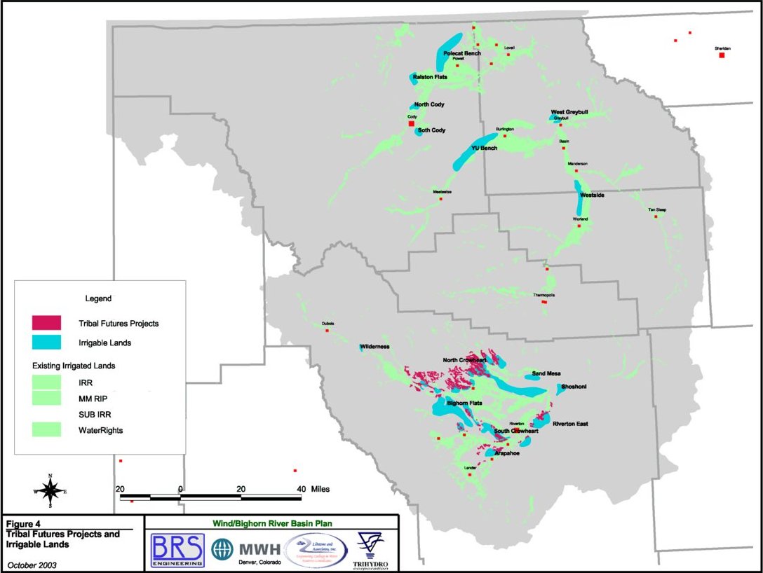
Similarly, the Tribal Futures Projects were modeled with a Full Supply diversion requirement of approximately 198,000 acre feet for those projects proposed within the Wind and Little Wind Basins. The Futures Projects would increase shortages within the Wind River Basin, not including the Popo Agie, by approximately 205,000 acre feet in dry years, 70,000 in average years and 39,000 in wet years. The dry year value actually exceeds the diversion requirement because return flows for the North Crowheart Project accrue to the river at locations where they cannot be re-diverted by downstream entities. Figure 4 depicts the Tribal Futures Projects and the Irrigable lands in the WBHB. Downstream of Boysen Reservoir, the model does not show any impacts. This is because Boysen Reservoir acts as a ôbufferö between the Wind and Bighorn Basins. More storage within the reservoir can be used to meet downstream demands. The model shows, however, as time progresses, there may be more difficulty in filling Boysen Reservoir if all of the proposed Futures Projects are on-line. A more detailed carry-over storage analysis is required to analyze the full affects of Futures Projects on storage in Boysen Reservoir.
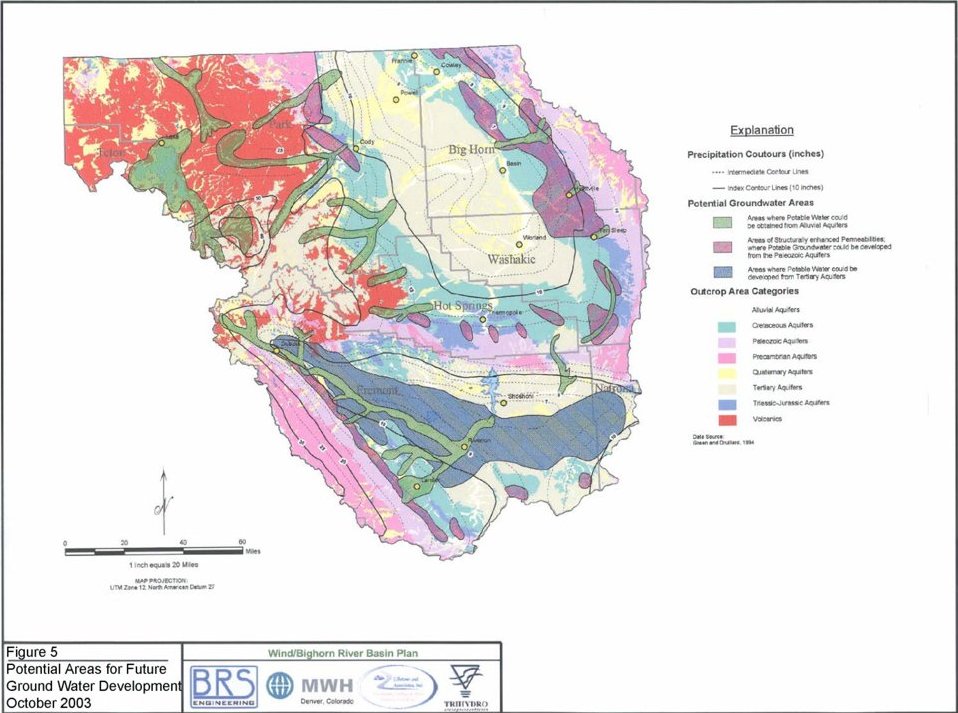
(Click on image for more details)Ground Water Availability Within the limits of the planning area, ground water is the primary source of water for many uses. While the Madison and Wind River Aquifers represent the most utilized sources of municipal supply, 13 aquifers have been identified as important water sources for different reasons throughout the WBHB. Potential areas for future ground water development (highlighted in green) are shown on figure 5. Based on recorded declines in water levels and wellhead pressures in these areas near Hyattville and Riverton, the Wyoming State Engineers Office may want to further investigate these areas and talk with local residents regarding the necessity of establishing control areas at these locations. Future Water Use Table 3 provides a summary of projected future water use in 2030 for the WBHB. Subsequent sections describe the general basis of this projection. Table 3 Summary of Wind/Big Horn Basin Water Use Forecasts
For purposes of the Wind/Bighorn Basin plan, three scenarios have been developed to simulate potential future development within the WBHB planning area. Future agricultural development was based on the irrigable lands and the proposed Tribal Futures projects. Future municipal and domestic water demand is directly related to population projections. Industrial growth in most sectors has remained flat or declined. Growth projections are based on the attraction of fossil fuel power generation to the WBHB area to meet projected increased power demand for local consumption. Although environmental and recreational demands on water availability are expected to increase these are generally non-consumptive uses and do not impact the demand projection. Similarly no change in water use from storage is currently projected. Identified Water Development Projects Over 200 water development projects were identified, addressing existing and future water shortages in the WBHB. Table 4 presents the ôshort listö of projects developed through the basin planning process. The ôshort listö was developed through a scoring and ranking process based on engineering, environmental, social and institutional factors. The list is not intended to be inclusive or exclusive, but rather a representation of the broad scope of potential water development projects in the WBHB.
(Click on image for more details)Table ES-4 Short-List of Water Development Projects
Power Study The Wind/Bighorn River Basin Power Study was conducted to analyze the potential for both hydropower and fossil fuel facilities within the WBHB. Several potential projects were analyzed to determine the technical feasibility of the project and the economics of project development. The gas turbine power plants were determined to be the most attractive option for new power generation within the WBHB. However, if any reservoir were to be further evaluated for water supply purposes, these evaluations should include a technical and economic analysis of the potential for power generation. For development of any of the proposed projects, a sponsoring group or agency would need to be identified and formed. More information on these projects can be found in the Wind/Bighorn River Basin Power Study. Summary This document is intended to provide a useful compilation of water related data for the Wind River, Bighorn, and Clarks Fork River Basins. The GIS and other electronic format components of the project are intended to allow this database to grow as new data becomes available. It is hoped that the completion of this river basin plan will foster discussion among potential water users and state officials relative to water development in the WBHB. The data presented in the basin report clearly shows that substantial water resources are available in the WBHB for development, but that the distribution and availability of the water resources in the WBHB relative to point of use is highly variable. Without future water projects, which address the development, storage, and distribution of Wyomingĺs water resources in the WBHB, chronic water shortages in specific localities will continue. References and Additional Information A substantial portion of information collected and developed as part of this project was developed as a Geographical Information System (GIS) product, which will be managed by Water Resources Data System - http://www.wrds.uwyo.edu/ (WRDS). GIS products include, but are not limited to: irrigated lands mapping and water right attribution; topography; climate; geology; hydrologic features and boundaries; and various man-made features such points of diversion, storage, and distribution. In addition, a surface water model for the entire WBHB was developed as a spreadsheet model in the format requested by the WWDC. Finally, detailed technical data and descriptions of each component of the basin plan are provided in the Wind/Bighorn River Basin Plan Final Report and associated Technical Memoranda prepared for this project. The Final Report and associated Technical Memoranda are available through the Wyoming State Waterplan, (http://waterplan.state.wy.us/plan/bighorn/bighorn-plan.html), in either .PDF format or HTML format. A printed version is available for checkout through the WRDS library. |
||||||