Wyoming State Water Plan
Wyoming State Water Plan
Wyoming Water Development Office
6920 Yellowtail Rd
Cheyenne, WY 82002
Phone: 307-777-7626

Wyoming Water Development Office
6920 Yellowtail Rd
Cheyenne, WY 82002
Phone: 307-777-7626


| SUBJECT: |
Appendix M Recreational Uses |
| PREPARED BY: | Bear River Basin Planning Team |
Introduction:
Recreational uses of water within the basin are significant from an economic standpoint as well as from a "quality of life" standpoint. Recreational use is viewed as non-consumptive. Such uses include boating, fishing, swimming and waterfowl hunting, among others. While consumption of water is usually not involved, the existence of a sufficient water supply for a quality experience is important. It is the objective of this memorandum to describe current water-based recreational opportunities in the basin, whether current use rates exceed capacities for use, and provide quantitative information wherever possible. Available recreational data within the basin is primarily qualitative.
Sources of information for recreational uses and the importance of water for those include the Wyoming Department of State Parks and Cultural Resources, the Wyoming Game and Fish Department, the Bridger-Teton National Forest, and the Bureau of Land Management.
This technical memorandum addresses current recreational uses by category, followed by a more detailed description of some of the more popular (and more heavily used) water-based recreational sites in the basin.
Boating:
The Bear River Basin's lakes and reservoirs are by far the most popular destinations for boating. The more popular of these sites in Wyoming are Sulphur Creek Reservoir and Woodruff Narrows Reservoir. Boating on the Bear River proper (or any of its tributaries) is relatively limited. The exception is the growing interest in kayaking and tubing along reaches of the Bear River, particularly in the Upper Wyoming reach near Evanston.
Little quantitative data exist on the numbers of watercraft using these facilities and whether numbers approach or exceed the saturation capacity of the water body visited. The Bureau of Reclamation has indicated that, while not the rule on Wyoming waters, a ceiling capacity of one boat per ten surface acres of water is used elsewhere to measure boating capacity. Unfortunately, quantitative boating data for the Bear River Basin was not available from the land management agencies contacted. Such numbers are typically more readily available where a permit process is required for boating (i.e. the Snake River in Grand Teton National Park, etc.).
A quality boating experience requires a water level (in lakes) or flow rate (in rivers) sufficient to support the function of boating, whether it be fishing, water- skiing or some other sport. Boating has not historically played a primary role in the determination of reservoir releases or the establishment of minimum flow criteria. Under Wyoming water law, it seems doubtful that recreational criteria will supercede other consumptive uses in the foreseeable future.
Fishing:
Fishing is a significant water-based recreational activity pursued in the basin. Fishing brings many visitors and residents to the region. As in boating, fishing is a non-consumptive use of water. However, the environmental importance of fisheries elevates its importance relative to river regulation and minimum instream flows. The Wyoming Game and Fish, in cooperation with the Wyoming Water Development Commission and the State Engineers Office is actively pursuing appropriate instream flow water rights to protect fisheries within the Basin. The instream flow filings to date have been primarily located in the upper reaches of Bear River tributaries. Instream flow filings are discussed in more detail in the Environmental technical memorandum.
The Wyoming Game & Fish Department classifies trout streams under five designations (WGF, rev. 1991). This river classification is unique to Wyoming Game & Fish Department and is not the same river classification used by Water Quality Division for classifying water quality. The Wyoming Game & Fish trout stream classification is as follows:
In the Bear River Basin there exist no waters currently classified as Class 1 or Class 2. Nonetheless, the Bear River Basin is considered by many to provide good to fair trout fishing opportunities in its reservoirs, lakes, streams, and rivers.
The Wyoming Game and Fish Department maintains the most complete database on fisheries and fisherman use in the state. They estimate that there are typically 9400 angler days on the streams within the basin and 7400 angler days on the lakes and reservoirs within the basin (primarily Sulphur Creek Reservoir, Woodruff Narrows Reservoir, and Lake Alice). Hence there are approximately 16,800 angler days within the Bear River Basin.
The Wyoming Game and Fish Department has also estimated the average angler expenditures to be $53.00 per day. This translates into an annual economic impact of angler usage within the Bear River Basin of $890,000 annually.
It is estimated that there are 405 stream miles capable of supporting game fish within the Bear River Basin. The Bear River mainstream is primarily a "put-and- take" sport fishery that is supported by local fish hatcheries. They keep the river stocked, primarily upstream of Evanston, for a sport fishery.
The Wyoming Game and Fish Department also estimates that the 'optimum' lake/reservoir angling acreage is 3080 acres. Again this angling acreage would primarily be associated with Sulphur Creek Reservoir, Woodruff Narrows Reservoir, and Lake Alice. Sulphur Creek Reservoir is required to maintain a minimum conservation storage pool of 4180 acre-feet (approximately 300 acres surface area) and maintains minimum downstream releases of 9 cfs for fishery habitat. Over the past 10 years, Sulphur Creek Reservoir has typically maintained a water surface elevation of over 7180 feet in all but the late summer months. That elevation translates into 14,500 acre-feet of storage and 570 acres of surface area.
Woodruff Narrows Reservoir maintains a minimum conservation storage pool of 1600 acre-feet (417 acres surface area) with minimum downstream releases of 10 cfs to the Bear River for fishery habitat. Historically, Woodruff Narrows Reservoir is filled to about 40,000 acre-feet (approximately 1660 acres surface area) by June of each year. By the end of September, the remaining averages 20,370 acre-feet (approximately 1330 acres surface area).
Waterfowl Hunting:
The harvest of migratory waterfowl is a recreational pursuit affected by the presence or absence of water. Wetlands and open water are needed for breeding, nesting, rearing, feeding and isolation from land-based predators. In the Bear River Basin of Wyoming, waterfowl hunting is pursued where sufficient local or migratory populations are available.
The setting of nation-wide waterfowl hunting seasons and bag limits is performed by the U.S. Fish and Wildlife Service (USFWS). Since 1995, the USFWS has set seasons to manage duck harvest rates under the concept of "Adaptive Harvest Management" or AHM (USFWS, 1999). This concept is described by the USFWS as follows:
"The annual process of setting duck-hunting regulations in the United States is based on a system of resource monitoring, data analysis, and rule making. Each year, monitoring activities such as aerial surveys and hunter questionnaires provide information on harvest levels, population size, and habitat conditions. Data collected from this monitoring program are analyzed each year, and proposals for duck-hunting regulations are developed by Flyway Councils, States, and the U.S. Fish and Wildlife Service (USFWS). After extensive public review, the USFWS announces a regulatory framework within which States can set their hunting seasons."Essentially, AHM allows annual duck population surveys and hunter input to re- evaluate seasons and harvest on an annual basis. States are then allowed to impose more stringent seasons and bag limits than the USFWS sets, if they wish. As populations increase above the desired population goal, hunting seasons and bag limits are made more liberal, while population decreases have the opposite effect. The primary population studied by the USFWS is the mid-continent mallard stock, with efforts underway to include other stocks and species. In recent years, duck populations have been strong and liberal seasons and bag limits have benefited sportsmen. This is especially true for the Pacific Flyway, which recently has seen longer seasons than the other flyways.
The general determination of duck hunting opportunities, therefore, is affected by extra-state duck populations and federal regulations. This is different from most all other hunting and fishing activities, wherein bag limits and seasons reflect local populations as reflected in WGF research and evaluations.
Hunter-days and harvest numbers for the 1999 duck hunting season provided by the Wyoming Game and Fish are summarized below:
| 1999 Estimated Number of Duck Hunters, Bear River Basin | |||
| Management Area | No. Hunters | No. Hunter Days | Harvest |
|---|---|---|---|
| Upper Wyoming (Upper Division of the Bear River) |
130 | 1427 | 875 |
| Lower Bear River (Central Division of the Bear River) |
98 | 519 | 1132 |
In like fashion, goose hunting seasons and bag limits are set under guidelines from the USFWS, although states have more flexibility in setting bag and possession limits. And like duck populations, goose populations are strong and increasing. With approval from USFWS, states can set special seasons to allow depredation harvest from growing local flocks. According to historic estimates, the Rocky Mountain Population (RMP) of Canada geese has grown approximately four-fold since 1972 (Wilkins and Cooch, 1999). Since 1989, populations have increased at a rate of eight percent per year. Hunter-days and harvest numbers for the 1999 goose hunting season as provided by Wyoming Game and Fish are summarized below.
| 1999 Estimated Number of Goose Hunters, Bear River Basin | |||
| Management Area | No. Hunters | No. Hunter Days | Harvest |
|---|---|---|---|
| Upper Wyoming (Upper Division of the Bear River) |
85 | 767 | 138 |
| Lower Bear River (Central Division of the Bear River) |
83 | 384 | 135 |
Swimming:
Swimming is generally undertaken incidental to other activities. While some lakes and reservoirs are suitable for swimming and water-skiing (i.e. Sulphur Creek Reservoir and Woodruff Narrows Reservoir), many are too cold for comfort, or have bottom strata not conducive to swimming. Swimming has become increasing popular at Bear River State Park, particularly near the bridge structure at the south end of the park.
Review of Major Water-Based Recreation Destinations:
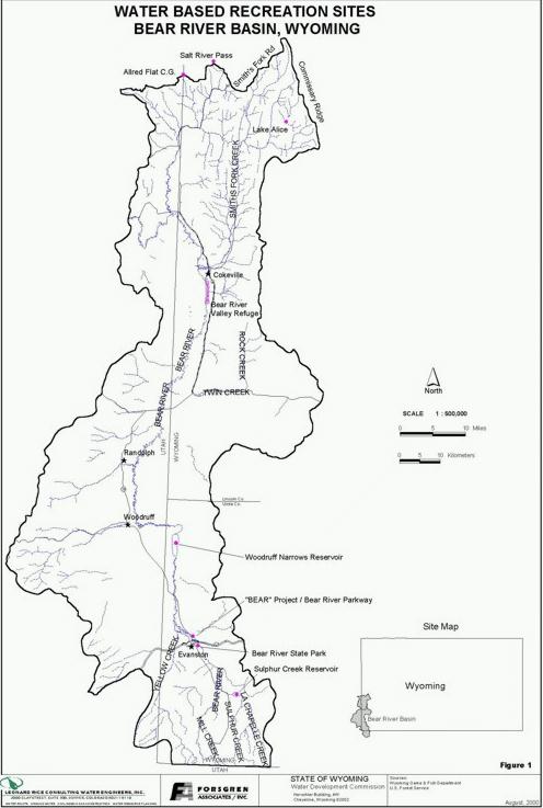
Information and data obtained from resource managers has been compiled to give the following descriptions of the basin's most popular recreation destinations:
The Bear River Valley Wildlife Refuge is located along the Utah and Wyoming border south of the Town of Cokeville, Wyoming. The area is approximately 16 miles long, bounded by Cokeville on the north and by the Beckwith-Quinn (BQ) diversion system. The refuge is maintained for aquatic fowl production.
The Bear River Valley Refuge is in the land acquisition phase, currently purchasing land from willing buyers. The U.S. Fish and Wildlife Service has signed an agreement with the State Engineer's Office to maintain historical quantities and timing of depletions.
The refuge is viewed more as an environmental feature of the basin rather than a recreational. More detailed information on the management of the Bear River Valley Refuge, therefore, is contained in the Environmental Technical Memorandum.
The Kemmerer Ranger District of the Bridger-Teton National Forest is in the process of completing a "Landscape Assessment" for the entire Kemmerer Ranger District. This District encompasses the southern end of the Bridger-Teton National Forest, of which approximately one-third to one-half lies in the Bear River Basin. Recreational use within the District will be presented in that report. John Wytanis from the Kemmerer District provided some 'draft' excerpts from that report for use in this memorandum. Recreation Opportunity Spectrum (ROS) settings within the assessment area vary from primitive to roaded natural. Certain major recreation corridors and backcountry areas have been described with a summary of their attributes. Within the Bear River Basin are:
Commissary Ridge and Lake Alice Area - Large backcountry area, non- motorized travel. Lake Alice is major attraction and has developed campsites. Remote area, primitive setting, low use. Limited developed trailheads.
Smith's Fork Road - Remote, low-development level, low use. Access to Commissary Ridge, through route with LaBarge and Greys River roads, some semi-developed and undeveloped roadside camps. On low end of roaded natural class in terms of development level; use low except during hunting season. Snowmobiling in winter. Wildlife viewing, especially moose and beaver in riparian.
Hobble Creek - Only road that gives access deep into backcountry area and Lake Alice, a large natural lake created by landslide. Good road, long, remote, accessed from Cokeville. Developed campground and trailheads. Main attraction is Lake Alice – fishing, camping on lakeshore.
Salt River Pass / Allred Flat - Allred Flat is the only campground in the area and primarily serves visitors travelling to Yellowstone area from several directions. Primarily roaded natural setting.
There are currently 14 Outfitter-Guides operating in the assessment area. Of these 8 are hunting, 2 fishing, 3 horseback trail rides, and 1 backpacking. Fishing Outfitter-Guide use is limited to a maximum of 600 service days per year. The actual use since 1991 has been steadily increasing with use in 1998 at approximately 400 service days.
There is 1 developed fee campground in the Bear River Basin portion of the assessment area and that is Allred Flat. There is non-fee, limited service campgrounds at Lake Alice, Hobble Creek and Allred Flat also have developed picnic sites. There are 3 other developed picnic sites: Big Spring, Crystal Lake, and Lake Alice.
The Allred Flat Campground spring water system was unable to meet water quality standards and was directed to be closed in 1998 by the Environmental Protection Agency. Current water needs for campers is only marginally met by two hand water pumps.
The Bureau of Land Management (BLM) administers lands within the Bear River Basin but does not ,at this time, have any recreational management plan. There are no campsites or picnic sites within the Bear River Basin that are managed by the BLM.
Bear River State Park is the only State Park within the Bear River Basin. Bear River State Park is located immediately upstream of Evanston and is bisected by the Bear River. The 280 acres that make up Bear River State Park offers ideal areas for picnicking, hiking, wildlife viewing, group activities, bicycling, skiing, rollerblading, and many other activities. The park is a day use only park with no overnight camping allowed. Within the park, but separated from the day use facilities is a Travel Information Center. This center provides a 24-hour Rest Area for travelers.
Visitation at the park has been steadily increasing over the past 5 years. Summarized below are both the visitation and the number of visitor-days to the park from 1995 through 1999. "Visitation" is defined by the Division of State Parks & Historic Sites as the total number of persons entering the State Park to carry on one or more recreation activities. "Visitor Day" is twelve (12) visitor hours that may be accumulated continuously or simultaneously by one or more visitors. These counts do not include visitor use of the Travel Center.
| Bear River State Park Visitation, 1995-1999 | |||||
| 1995 | 1996 | 1997 | 1998 | 1999 | |
| Visitation | 156,142 | 182,685 | 190,684 | 211,324 | 222,094 |
| Visitator Days | n/a | n/a | n/a | 35,080 | 36,867 |
The park has nearly two miles of hiking foot trails within the park limits. The park is actually included within the Evanston city limits and ties to the Bear Project, a greenbelt project underway by the city described hereafter. When combined, the Bear Project and the Bear River State Park provide 3.1 miles of foot trails along 3.5 river miles of the Bear River. In the winter these foot trails double as cross-country ski trails.
Many groups hold events at the park. Scouts frequently hold meetings and campouts at the park. Businesses, churches and families reserve the shelters for picnics and meetings. The annual Pony Express Race often uses the park as a start point and the park provides the ideal environment for the annual Learn to Cross-Country Ski Day. In recent years the stretch of the Bear River within the park has become increasingly popular for kayaking, tubing, and swimming. The annual Bear River Rendezvous takes place on the weekend prior to the Labor Day Weekend and is held in the park. The rendezvous is a destination event providing visitors with a window into Wyoming's past. Mountain men and women compete using black powder rifles and knives, recreating a typical rendezvous of the mid-1800's. The attendance is typically between 300 and 600 visitors to the rendezvous over the 3-day weekend.
According to the 1997 Wyoming State Parks and Historic Sites Visitor Survey, compiled by the University of Wyoming, Survey Research Center, approximately 86 percent of all visitation to Wyoming's state parks occurs in the months of June, July and August, with attendance in each of those months almost equal. Slightly over half the visitors are first-time visitors. Approximately one in four visitors is traveling with a boat or canoe, indicating some water-based recreation is intended, either at that location or elsewhere on that particular trip. Approximately 58 percent of the visitors are from out of state.
The stated water-related activities undertaken by visitors while they were at a park or historic site included:
| 28.1% | Nature/Wildlife Viewing |
| 24.5% | Swimming |
| 9.7% | Water Skiing |
| 23.5% | Fishing |
| 18.4% | Boating |
While these data describe statewide visitation to all parks and historic sites, some of which expressly provide water-based activities (such as Glendo or Boysen), it does indicate that a significant percentage of summer recreationists explicitly pursue water-related recreation.
Additional data exist pointing to the importance of these state sites, and presumably other non-state destinations as well, to the vacationer and recreationist. Almost 79 percent say that the particular site they visited was important to their recreational activities. A similar number say the park/site they visited was adequate for current and future visitors. Over 91 percent said it is important to preserve park lands/historic sites for future generations. Finally, over 63 percent said they either have visited, or plan to visit, other parks/sites in the same summer.
The BEAR project, also know as the Bear River Parkway, is located in the City of Evanston. It is a comprehensive approach to recreational and development and environmental enhancement. There is a focus on youth and river environment educational opportunities. The project is supported by the City of Evanston, yet is funded by the city and private donations. The project is directed by an independent board comprised of private citizens.
The overall project is still under development. Components of the parkway include skating and fishing ponds, picnic areas, the reconstruction of historic "Red Bridge" across the river, trails that tie into the Bear River State Park.
The Bear River parkway is very popular for hiking, fishing, and ice skating in the winter months. It is also a popular gathering place for numerous events intended enhance economic development and to promote the sense of community in Evanston. These events include:
Resources: