Wyoming State Water Plan
Wyoming State Water Plan
Wyoming Water Development Office
6920 Yellowtail Rd
Cheyenne, WY 82002
Phone: 307-777-7626

Wyoming Water Development Office
6920 Yellowtail Rd
Cheyenne, WY 82002
Phone: 307-777-7626


The basin water use profile provides an inventory of water use and water development projects. It not only provides the necessary understanding of the location, source, and quantity of basin water use, but also provides an understanding of how water is used. Basin water use was determined for the following categories, which when combined define the total water consumed or lost due to human influence in the basin.
The existing water use profile is the basis for the subsequent sections in the report. The current surface water use and operations were used to develop the surface water spreadsheet models that help to identify water in the basin available for future development. The current ground water use and well yields were used to identify aquifers that have potential for future development. Existing water use, when tied to current economic and demographic conditions, were used to estimate the potential water use associated with future growth.
The surface water spreadsheet models were developed to represent dry, normal, and wet hydrologic conditions over a recent historic period. The basin water use profile supported the modeling efforts, therefore, it was necessary to understand changes in water use and basin operations during that period. In each of the water use categories an assessment was made of both existing and historic use for the selected study period.
3.1 Study Period
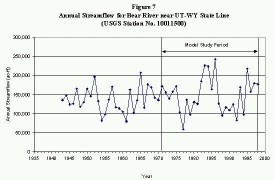
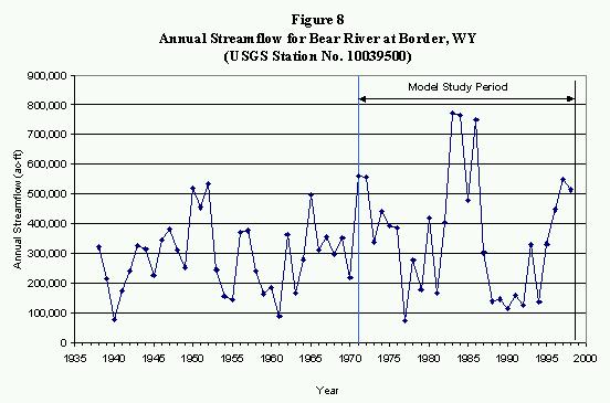
The surface water spreadsheet models were developed to represent dry, normal, and wet hydrologic conditions in the Bear River Basin. As discussed in Appendix C, the period 1971 through 1998 was selected for use in the modeling effort. Long-term USGS streamflow gages in both the Upper and Central Divisions were reviewed to select the study period. Figure 7 shows the long-term streamflow for the USGS Bear River near Utah/Wyoming State Line gage, located where the Bear River first enters Wyoming from the south. Figure 8 shows the long-term streamflow for the USGS Bear River at Border, Wyoming gage, located where the Bear River flows into Idaho. As this figure demonstrates, the 1971 through 1998 period was selected because it is statistically similar to long-term conditions and includes dry, normal, and wet hydrologic years.
3.2 Agricultural Water Use
Crop consumptive use accounts for the vast majority of water use in the Bear River Basin. The following general steps were followed to determine the actual agricultural consumptive use of water:
In addition, livestock consumptive use is included in agricultural water use estimates.
3.2.1 Key Structures
There are over 100 agricultural diversions in the Bear River Basin in Wyoming. Many of the smaller diversions are on non-compact tributaries or do not greatly effect the administration and operations in the basin. Therefore, key structures were identified to document operations, and take forward into the surface water spreadsheet modeling effort.
Key structures were initially identified as river headgate structures typically diverting at least 10 cfs. Local water administrators and users assisted in adding diversion structures to the key list that have regulatory or operational significance within the basin. Appendix D contains a memorandum describing the selection of key structures. Other agricultural diversions within the basin were aggregated into groups, based on the location of their river headgates and irrigated acreage, assuring that 100 percent of agricultural use is represented in the profile. The following identifies the approach to determining the water use for key and aggregated structures:
The following structures were identified as key in the Upper Division. Each of the structures identified divert from the Bear River mainstem or slough.
The following structures were identified as key in the Central Division. Many of these structure divert from tributaries, as noted.
Detailed operating memoranda were developed for each of the key structures in the basin, as shown in Appendix D. They provide the basis for the crop consumptive use analyses and the surface water spreadsheet modeling efforts. Don Shoemaker, Water Commissioner for Division IV, District 4, assisted in the development of the operating memoranda for diversions in the Upper Division. Kevin Wilde, Lead Hydrographer for Division IV, assisted in the development of operating memoranda for diversions in the Central Division. Each memorandum provides the following details:
3.2.2 Irrigated Acreage
Irrigated acreage mapping was developed by States West Water Resources Corporation under a separate contract with the WWDC. The mapping represents areas of irrigated acreage, referred to as irrigated acreage polygons, in the Bear River Basin in 1998. The irrigated acreage was developed using a combination of aerial and satellite photography, as described in Appendix E. Table 6 reports the 1998 irrigated acreage by compact division. Figure 9 shows the irrigated acreage in the basin.
Table 6
Irrigated Acreage in the Bear River Basin, Wyoming
| Location | Irrigated Acreage (acres) |
| Upper Division | 40,400 |
| Central Division | 23,500 |
| Total Bear River Basin | 63,900 |
Wyoming Agricultural Statistics, reported each year by county, were perused to determine how acreage has changed over the study period. County agricultural statistics generally report cash crops only, therefore they are not a good indicator of actual acreage. A large majority of the acreage in the Bear River basin is irrigated meadow that is either used for grazing or hayed for on-farm use, and therefore not reported as a cash crop. However, information from local water users indicates that irrigated lands have been fairly consistent since 1971. Water rights for only about 2,900 additional acres have been permitted in the basin since 1971, representing less than 5 percent of the total acreage. Based on this information, a constant acreage was used over the study period.
The operating memoranda, provided in Appendix D, provide crop types for each of the key structures. In the Upper Division, approximately 99 percent of the irrigated acreage is meadow grass. Only about 1 percent is planted in alfalfa. In the Central Division, about 86 percent is meadow grass, with the remaining planted in alfalfa and small grains.
3.2.3 Supply Source for Irrigated Acreage
Water supply-limited consumptive use is the actual water used by the crop, limited by water availability. To estimate water supply-limited consumptive use, it is necessary to know the amount of water supplied to irrigated acreage. Therefore, an investigation was performed to link irrigated acreage polygons to individual diversion structures through water rights. The surface and ground water rights permitted to serve some or all of the land within each irrigated acreage polygon were determined from the original records on file at the SEO. Because water right permits specify both the diverting surface or ground water structure and the permitted lands, this allowed irrigated acreage to be associated with a supply source. This process is documented in Appendix F.
A total of 82 irrigation diversion structures were identified. There were 558 individual water rights associated with these structures, including original supply, supplemental supply, and additional supply permits. Note that this may not represent all water rights in the basin, only water rights associated with acreage defined as irrigated in 1998. A total of 49 wells were identified as permitted for irrigation or permitted for a combined use including irrigation.
3.2.4 Potential Crop Consumptive Use and Irrigation Water Requirement
Potential crop consumptive use is an estimate of how much water crops can consume if provided with a full supply. Monthly potential crop consumptive use, or crop evapotranspiration, was calculated for key and aggregate structures for the period 1971 through 1988 using the Blaney-Criddle approach developed by the former Soil Conservation Service (now the Natural Resources Conservation Service). This method uses temperature, latitude, acreage, crop types, and crop parameters on a monthly time- step. Historic temperature data from the National Weather Service climate station in Evanston (Evanston 1 E) was used to represent conditions in the Upper Division. Historic temperature data from the climate station in Sage (Sage 4 NNW) was used to represent conditions in the Central Division.
Local crop parameters, developed under a cooperative project sponsored by the Bear River Commission, were used to better represent conditions in the Bear River Basin. The project results were published in the Duty of Water Under the Bear River Compact: Field Verification of Empirical Methods for Estimating Depletion - Research Report 125, January 31,1989, Robert W. Hill, et al. Details of the potential crop consumptive use analysis are provided in Appendix G.
The amount of water the crops need from irrigation, termed irrigation water requirement, is the potential crop consumptive use less the amount of precipitation available to the crop. To be consistent with the consumptive use analyses performed under the Bear River Commission project, 80 percent of rainfall during the irrigation season was estimated to be effective in meeting crop demands. The average annual irrigation water requirements in the Wyoming portion of the Upper and Central Divisions, estimated for the period 1971 through 1998, are shown in Table 7.
Table 7
Average Irrigation Water Requirement (IWR)
1971 through 1998
| Location | IWR (acre-feet) |
| Upper Division | 64,300 |
| Central Division | 32,600 |
| Total Bear River Basin | 96,900 |
3.2.5 Water Supply-limited Consumptive Use
Irrigation water requirement is an estimate of the amount of irrigation water crops would use if they had a full supply. However, in the arid west most farming operations by necessity grow crops with less than a full supply. Water-supply limited consumptive use is the amount of water actually used by the crop. In the Bear River Basin in Wyoming, there are five measurable sources of agricultural supply:
The methodologies used to estimate water supply-limited consumptive use for the basin are discussed in detail in Appendix G. It is important to note that not all the water diverted at the river headgate is available to satisfy crop needs. Diversions for agricultural use experience both conveyance losses and application losses, and these losses return to the river as surface runoff or deep percolation. Appendix H discusses the development of efficiencies and return flow patterns for estimating water available at the crop, and for use in the surface water spreadsheet models.
Table 8 shows the average annual irrigation water requirement, supply-limited consumptive use, and percent shortage by division. The supply-limited consumptive use includes consumptive use of both surface and ground water sources.
Table 8 Average Annual Crop Consumptive Use Estimates 1971 through 1998
| Location | Irrigation Water Requirement (acre-feet) | Supply-Limited CU (acre-feet) | Percent Shortage |
|---|---|---|---|
| Upper Division | 64,300 | 62,600 | 2.6 % |
| Central Division | 32,600 | 31,600 | 3.1 % |
| Total Bear River Basin | 96,900 | 94,200 | 2.8 % |
Figures 10 and 11 show the annual irrigation water requirement, consumptive use of surface water, and consumptive use of ground water in the Upper and Central Division for 1971 through 1998.
Figure 10
Upper Division Annual Crop Requirements and Use - 1971 through 1998
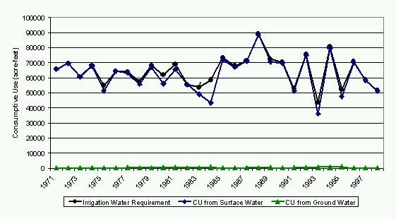
Figure 11
Central Division Annual Crop Requirements and Use - 1971 through
1998
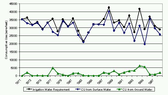
Figure 12 shows the average annual supply-limited crop consumptive use for the Upper and Central Division from 1971 through 1998. Note that this annual consumptive occurs during the irrigation season, generally from the beginning of May through September.
Figure 12
Average Annual Supply-Limited Consumptive
Use by Division 1971 through
1998
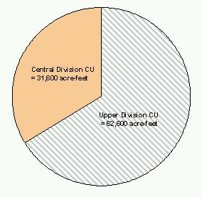
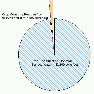
Figure 13 shows Wyoming's average annual crop consumptive use by supply for 1971 through 1998 for the Bear River Basin.
Figure 13
Average Annual Supply-Limited Consumptive
Use by Source 1971 through
1998
3.2.6 Summary of Supplemental Agricultural Water Sources
Reservoir Supplies
As shown by the small shortages in Table 8, the Bear River Basin in Wyoming generally has a reliable source of water for irrigation. There are three relatively large reservoirs in the Upper Division that allow demand to be satisfied except in the driest years. Whitney, Sulphur Creek, and Woodruff Narrows Reservoirs provide supplemental water primarily for irrigation, although Sulphur Creek Reservoir was enlarged in 1982 providing storage for the City of Evanston.
A summary of the permitted storage in the Bear River Basin in Wyoming is included in Appendix I. Also included are technical operating memorandum for Whitney, Sulphur Creek, Woodruff Narrows, Broadbent, and Ben Reservoirs. They provide the basis for the modeling of reservoirs in the surface water spreadsheets. The following information is included in the reservoir operating memorandums:
Ground Water Supplies
As shown in Figure 11, supplemental irrigation wells in the Central Division help to satisfy irrigation water requirements when surface water is not available. The large majority of irrigation wells are developed in the alluvial aquifer system. The increased use of ground water for irrigation in the Central Division reflects the fact that there is no significant storage available for supplemental supply. The water rights investigation showed approximately 1,500 acres permitted to use ground water as the original supply for irrigation and approximately 6,200 acres permitted to use ground water as an additional supply for irrigation.
The consumptive use of ground water for agriculture is estimated to be approximately 1,900 acre-feet per year. Most of the ground water is applied to the crops through sprinkler irrigation techniques, which are generally able to efficiently use 80 percent of the water. Therefore, the amount of ground water withdrawn for agricultural use is estimated to be approximately 2,400 acre-feet per year.
3.2.7 Livestock Consumptive Use
Livestock consumptive use was determined based on the number of livestock, estimated yearly by county. There is a significant amount of both cattle and sheep within the Bear River Basin. Various sources have estimated daily livestock consumptive use. The U.S. Environmental Protection Agency estimates from the Manual of Individual and Non-Public Water Supply Systems (1991) in gallons per day per head were adopted and are shown in Table 9.
Table 9
Average Daily Consumptive Use by Livestock
| Livestock Type | Daily Water Use (gal/head) |
|---|---|
| Cattle | 12 |
| Sheep | 2 |
Cattle and sheep population estimates have been relatively constant throughout the 1971 through 1998 study period. As noted, the number of livestock are reported by county. It was estimated that approximately 25 percent of the livestock in both Uinta and Lincoln Counties are within the Bear River Basin. The remaining 75 percent of livestock are within the Green River and Snake River Basins. Table 10 shows the estimated number of livestock and associated consumptive use.
Table 10
Average Annual Livestock Consumptive Use - 1971 through 1998
| Location | Number of Livestock | Consumptive Use (acre-feet) | |||
|---|---|---|---|---|---|
| Cattle | Sheep | Cattle | Sheep | Total | |
| Upper Division | 18,000 | 17,500 | 242 | 40 | 282 |
| Central Division | 7,000 | 3,000 | 94 | 7 | 101 |
| Total | 25,000 | 20,500 | 336 | 47 | 383 |
3.3 Municipal and Domestic Use
Currently, around 15,100 people live in the Bear River Basin in Wyoming. More than 80 percent of the population lives within the boundaries of the City of Evanston or the Town of Cokeville. Table 11 shows an estimate of the current population by county and city service area.
Table 11
Approximate Current Populations
| Location | Lincoln County | Uinta County | Total |
|---|---|---|---|
| Evanston Service Area | 12,200 | 12,200 | |
| Cokeville Service Area | 500 | 500 | |
| Unincorporated Area | 400 | 2,000 | 2,400 |
| Total Basin | 900 | 14,200 | 15,100 |
Municipal technical operating memoranda were developed for Evanston and Cokeville, and are included in Appendix J. They provide the basis for the estimate of municipal consumptive use and for the modeling of cities in the surface water spreadsheets. The following information is included in the municipal operating memoranda:
3.3.1 Evanston Municipal Consumptive Use
Evanston currently relies primarily on treated surface water. However, the city owns and maintains several ground water wells that, prior to 1990, were the primary source of municipal water. In 1988, Evanston began construction on a surface water reservoir, diversion and pipeline project that would allow them to meet normal demands with surface water from the Bear River. The project, completed in 1990, included:
The city's current annual withdrawal of surface water is approximately 4,300 acre-feet. The highest monthly demands coincide with warmer months when lawn irrigation is added to indoor use. The actual consumptive use of diverted municipal water for Evanston is approximately 1,000 acre-feet per year. The non-consumed water either returns to the Bear River as lawn irrigation return flows, or is discharged from the wastewater treatment plant into the Yellow Creek tributary of the Bear River.
3.3.2 Cokeville Municipal Consumptive Use
Cokeville relies on ground water from two municipal wells located about 2.2 miles east of town in the Smith's Fork/Spring Creek drainage. These wells pump water from the Cretaceous Thomas Fork Formation, which can be categorized as a bedrock aquifer. Water is disinfected at the well head and pumped to town without further treatment. The disinfected water can either be delivered directly to users or stored for peak demand use.
The town's current annual withdrawal of ground water is approximately 810 acre-feet. The highest monthly demands coincide with warmer months when lawn irrigation is added to indoor use. The actual consumptive use of diverted municipal water for Cokeville is approximately 40 acre-feet. The non-consumed water either returns to the Bear River as lawn irrigation return flows, or is discharged from the wastewater treatment plant directly to the Bear River.
3.3.3 Rural Domestic Consumptive Use
Rural domestic water use is primarily from individual wells, mostly developed in the alluvial aquifer system. The estimated withdrawal for rural domestic water use is 180 gallons per capita day. Because many rural users are on septic systems, it is assumed that none of the water withdrawn for domestic use is available as returns. Therefore, rural domestic consumptive use is equivalent to rural pumping. Based on the unincorporated population in the Bear River Basin, shown in Table 11, approximately 500 acre-feet per year is both withdrawn from wells and consumed. This use is distributed throughout the Bear River Basin in Wyoming.
3.3.4 Total Municipal and Domestic Consumptive Use
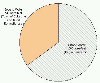
Figure 14 shows the total municipal and domestic consumptive use in the Bear River Basin for the Upper and Central Divisions in Wyoming. Figure 15 shows the water use by source. The population and associated water use in the Bear River Basin in Wyoming has generally increased by about 4 percent annually during the 1971 through 1999 study period selected for the modeling effort.
Figure 14
Total Current Municipal and Domestic Water Use by Division
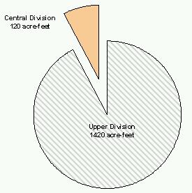
Figure 15
Total Basin Current Municipal and Domestic Use by Source
3.4 Industrial Use
Industrial water use in the Bear River Basin in Wyoming represents only a small proportion of overall basin water use. There are some "light" industrial uses within the City of Evanston that are supplied water by the city. Their use has been included in the municipal use described above. Currently, the only substantial self-supplied industrial water use in the Bear River Basin is for purposes of natural gas processing. Two energy firms, Chevron and BP Amoco, account for essentially all self-supplied industrial water use. A detailed description of the industrial use in the basin in provided in Appendix K.
Natural gas production within the Bear River Basin is divided into two units; the Painter Resource Unit and the Whitney Canyon/Carter Creek area. Chevron and BP Amoco have gas-processing facilities in both units. The Chevron gas plant in the Whitney Canyon/Carter Creek field uses a water intensive process. They pump surface water through a pipeline from the stilling basin below Woodruff Narrows Reservoir. The total water use at that plant is approximately 310 acre-feet per year.
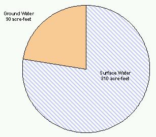
The remaining water demands for natural gas processing are entirely supplied from groundwater wells, and generally use less intensive water processes. The average annual ground water use for gas processing is approximately 90 acre-feet per year. These wells are outside the Bear River alluvium and likely pump from a bedrock aquifer formation. Industrial water use for gas processing has been relatively constant since the mid-1980s when the fields began producing. Figure 16 shows the total industrial water use in the basin by source.
Figure 16
Total Basin Current Industrial Water Use by Source
3.5 Environmental Use
Environmental water use generally includes the following:
Instream flows and reservoir releases are considered non-consumptive. Minimum reservoir pools are generally charged with a percent of the reservoir evaporation losses. Creation and maintenance of wildlife habitat, depending on the type of vegetation and amount of ponds created, consumes water at a rate equal to or greater than irrigated acreage. A detailed analysis of environmental use in the Bear River Basin is included in Appendix L.
3.5.1 Instream Flows
In 1986, the State of Wyoming passed legislation defining instream flow as a beneficial use of water, and stipulated how instream flow water rights would be filed, evaluated, and ultimately regulated. The legislation is codified within Wyoming Statutes at S41-3-1001 to 1014. This allows for instream flow water rights to be filed or granted on unappropriated water originating as natural flow or from storage in existing or new reservoirs. For natural sources, the flow amount is defined as the minimum needed to "maintain or improve existing fisheries". For storage water, the flow amount is defined as the minimum needed to "establish or maintain new or existing fisheries".
The Wyoming Game and Fish Commission has indicated that instream flow filings are insurance policies that protect wildlife from the impacts of unknown future upstream development. The main goal for instream flow rights in the Bear River Basin is to help preserve and manage habitat for the Bonneville Cutthroat Trout, which is proposed for listing under the Endangered Species Act. The Game and Fish Commission has indicated that the habitats in the central Bear River Basin and its tributaries are better headwater habitats for the Bonneville Cutthroat Trout than other areas of the basin.
There are currently 17 instream flow filings in the Bear River Basin in Wyoming. Although none were permitted at the time of this study, there was no significant opposition to the filings at the public hearing. The filing are all in the Central Division on tributaries to Smith's Fork or on Raymond Creek. The current filings are above the irrigation diversion on the respective tributaries. Figure 17 shows the location of the instream flow segments.
3.5.2 Minimum Reservoir Conservation Pools and Bypass Requirements
In general, conservation pools are intended to provide the minimum volume of water necessary to maintain the existing aquatic life in the reservoir. Because on-stream reservoirs disrupt the natural flow in a stream, minimum bypass requirements are often dictated during the permitting process to provide the minimum flow downstream required to maintain existing fisheries. Table 12 shows the conservation pools and minimum releases for Sulphur Creek and Woodruff Narrows Reservoirs.
Table 12
Minimum Reservoir Pools and Releases
| Reservoir | Conservative Pool (acre-feet) |
Minimum Release (cfs) |
|---|---|---|
| Sulphur Creek Reservoir | 4,180 | 9 |
| Woodruff Narrows Reservoir | 4,000* | 10 |
| *Temporary storage account of 4,000 acre-feet was set up to accommodate an agreement between the Reservoir Company and the Utah Department of Fish and Game to supply the 10 cfs winter minimum release for fishery purposes. | ||
3.5.3 Wildlife Habitat
There is one wildlife refuge in the Bear River Basin in Wyoming that is currently in the land acquisition phase. The Cokeville Meadows National Wildlife Refuge (formerly referred to as the Bear River Valley Refuge) is located in Wyoming upstream of the Town of Cokeville. The area is approximately 16 miles long. The refuge will be maintained for aquatic fowl production.
A memorandum of understanding was signed by the U.S. Fish and Wildlife Service and the Wyoming State Engineer in October 1990. This memorandum is intended to assure that the wildlife refuge operates under Wyoming Water Law and protects downstream water user interests. The Cokeville Meadows National Wildlife Refuge is currently purchasing lands from willing sellers. The purchased lands, and remaining private lands within the designated refuge area, continue to irrigate crops. The consumptive use associated with this area is included in the agricultural consumptive use estimates. The memorandum of understanding dictates that future operations cannot deplete water in excess of historic practices without prior approval from the Wyoming State Engineer.
3.6 Recreational Use
Recreational uses of water within the basin are significant from an economic standpoint as well as from a "quality of life" standpoint. While consumption of water is usually not involved, the existence of a sufficient water supply for a quality experience is important. Recreation water use in the Bear River Basin in Wyoming includes:
Figure 18 shows the location of water based recreation sites in the Bear River Basin. A detailed summary of recreation use in the basin in provided in Appendix M.
3.6.1 Boating
Although boating on the Bear River and its tributaries is relatively limited, the Bear River Basin reservoirs are a popular destination for boaters. Both Sulphur Creek and Woodruff Narrows Reservoirs offer boating opportunities, however, it is difficult to quantify the use because neither reservoir requires boating permits.
A quality boating experience requires sufficient reservoir water levels. In recent years, the water levels have remained adequate year-round in Sulphur Creek Reservoir. Spring and early summer water levels in Woodruff Narrows Reservoir are sufficient for boating, and may extend throughout the year.
3.6.2 Fishing
Fishing is a significant water-based recreational activity in the basin, pursued by residents and visitors. As in boating, fishing is a non-consumptive use of water. However, the environmental importance of fisheries elevates its importance relative to river regulation and minimum instream flows, as discussed above.
The Wyoming Game & Fish Department classifies trout streams under five designations (WGF, rev. 1991). This river classification is unique to Wyoming Game & Fish Department and is not the same river classification used by Water Quality Division for classifying water quality. The Wyoming Game & Fish trout stream classification is as follows:
In the Bear River Basin there exist no waters currently classified as Class 1 or Class 2. However, the Bear River Basin is considered by many to provide good to fair trout fishing opportunities in its reservoirs, lakes, streams, and rivers. The Wyoming Game and Fish Department estimates that there are typically 9400 angler days on the streams within the basin and 7400 angler days on the lakes and reservoirs within the basin (primarily Sulphur Creek Reservoir, Woodruff Narrows Reservoir, and Lake Alice).
3.6.3 Waterfowl Hunting
The harvest of migratory waterfowl is a recreational pursuit affected by the presence or absence of water. Wetlands and open water are needed for breeding, nesting, rearing, feeding and isolation from land-based predators. In the Bear River Basin, waterfowl hunting is pursued where sufficient local or migratory populations are available. Hunter- days and harvest numbers for the 1999 duck hunting season and goose hunting season, provided by the Wyoming Game and Fish, are shown in Tables 13 and 14.
Table 13
1999 Estimated Number of Duck Hunters
| Management Area | No. Hunters | No. Hunter Days | Harvest |
| Upper Bear River(Upper Division) | 130 | 1,427 | 875 |
| Lower Bear River(Central Division) | 98 | 519 | 1,132 |
| Basin Total | 228 | 1,946 | 2,007 |
Table 14
1999 Estimated Number of Goose Hunters
| Management Area | No. Hunters | No. Hunter Days | Harvest |
| Upper Bear River(Upper Division) | 85 | 767 | 138 |
| Lower Bear River(Central Division) | 83 | 384 | 135 |
| Basin Total | 168 | 1,151 | 273 |
3.6.4 Swimming
Swimming is generally undertaken incidental to other activities. While some lakes and reservoirs are suitable for swimming and water-skiing (i.e. Sulphur Creek Reservoir and Woodruff Narrows Reservoir), many are too cold for comfort, or have bottom strata not conducive to swimming. Swimming has become increasingly popular at Bear River State Park, particularly near the bridge structure at the south end of the park.
3.7 Reservoir Evaporation
End of month reservoir levels are not generally available for the smaller reservoirs in the basin. Nor is this information available for Whitney Reservoir, Ben and Broadbent Reservoirs, or Woodruff Narrows Reservoir. Some reservoir level information is available for Sulphur Creek, but not on a continuous basis. In addition, elevation/area/capacity information is not available for most of the storage in the basin. Therefore, a conservative estimate of reservoir evaporation was made using the following general procedure:
The storage summary memorandum, presented in Appendix I, determined total permitted storage in the basin as shown in Table 15. The corresponding estimated surface area for this storage is 1,650 acres. Essentially all the storage is the Upper Division.
Table 15
Current Storage in the Bear River Basin
| Storage Description | Storage Volume (acre-feet) |
|---|---|
| Pre-Compact Developed Storage (Pre-1955) | 3,284.43 |
| Original Compact Storage (1955-1976) | 13,183.00 |
| Total | 16,467.43 |
The total average annual evaporation rate at Green River Wyoming is 3.2 feet per year. Therefore, total basin losses due to evaporation is estimated to be 5,280 acre-feet per year. As discussed in Appendix I, about 13,000 acre-feet of storage has been constructed since 1976, therefore evaporation amounts are considerably less during the early years of the study period.
3.8 Total Basin Water Use
The total basin water consumed in Wyoming due to human influence include the categories discussed above as follows:
The current average annual total basin consumptive use is estimated to be 101,803 acre- feet per year. Figure 19 shows the average annual basin consumptive use by division.
Figure 19
Average Annual Basin Consumptive Use by Division
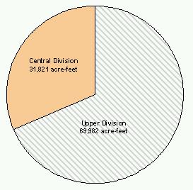
Figure 20 shows the average annual basin consumptive use by type.
Figure 20
Average Annual Basin Consumptive Use by Type
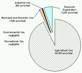
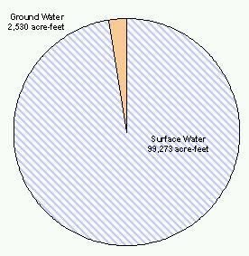
Figure 21 shows the average annual basin consumptive use by supply source.
Figure 21
Annual Basin Consumptive Use by Source