Wyoming State Water Plan
Wyoming State Water Plan
Wyoming Water Development Office
6920 Yellowtail Rd
Cheyenne, WY 82002
Phone: 307-777-7626

Wyoming Water Development Office
6920 Yellowtail Rd
Cheyenne, WY 82002
Phone: 307-777-7626


2.1 Basin Planning Process
Wyoming is undertaking a pro-active statewide water planning effort to represent changing conditions. Planning efforts in the late 1960s and early 1970's resulted in the publication of the Wyoming Framework Water Plan. The Framework Water Plan consisted of summaries of current water conditions and planned projections for six of the seven major river basins in Wyoming. The Bear River basin was not included in the Framework Plan. Due to technology constraints in the early 1970's, the data, mapping, and analyses tools used in developing the Framework Plan could not be easily updated to reflect changing conditions or new data.
The 1996 Legislature directed the Wyoming Water Development Commission (WWDC), the State Engineer's Office (SEO), and Wyoming Resources Data System (WRDS) to prepare a recommendation for updating the 1973 Framework Water Plan. The subsequent State Water Planning Process Feasibility Study Report (Feasibility Study), published in October 1998, determined that the planning process should accomplish the following three main objectives:
The Feasibility Study also identified the need for a State Water Planning team. This team is made up of staff members from the WWDC, the SEO, and the Water Resources Data System (WRDS) in the College of Civil and Architectural Engineering at the University of Wyoming. This WWDC is the lead agency and directed the Bear River Basin planning effort.
2.1.1 Local Participation
The Bear River Basin Advisory Group, comprised of citizens for the Bear River Basin, was assembled during the Feasibility Study, and served as the pilot for other basin advisory groups. The first meeting was held in 1997. The group members have interests in agricultural, municipal, industrial, recreational, and environmental water use. During the planning process, they provided the consultants valuable information regarding existing water uses, proposed water development, and current economic conditions. In addition, they provided a valuable sounding board and "reality" check for the assumptions and results of the planning process. Table 1 lists the Bear River Basin Advisory Group members.
Table 1
Bear River Advisory Group Members
| Member | Affiliation |
| Allan Burton | Mayor, City of Cokeville |
| Dennis Cornelison | Uinta County CD |
| Pat Thompson | Wyoming State Parks |
| James Crompton | Bear River Compact Commissioner |
| Will Davis | Mayor, City of Evanston |
| Kathy Davison | Lincoln County Commissioner |
| Eric Esterholdt | Lincoln County CD |
| Phil Orton | Represents Environmental Interests |
| Truman Julian | Wyoming Woolgrowers Association |
| Craig Lowham | Farm Federation |
| Craig Welling | Uinta County Commissioner |
| Gordon L. Park | Bear River Inc. |
| Ralph Stahley | Western Wyoming RC&D |
| Mike Sims | Sims Land and Livestock |
| John Teichert | Bear River Compact Commissioner |
The Feasibility Study identified the need for the services of a facilitator during advisory group meetings, in part to help assure that state planning agencies did not dominate the meetings. In addition, the facilitator was an unbiased mediator who assisted the group in establishing their role and accomplishing their tasks. John Talbot facilitated the initial meetings through July, 1999. At that time, Joe Lord took over as facilitator until the completion of the basin plan in November, 2000. The Bear River Basin advisory group has opted to continue meeting three times a year to discuss water issues, however, a facilitator will no longer be provided.
Basin advisory group meetings are open to the public, and participation was well beyond the designated advisory group. Besides a forum for local water users to provide information to consultants and consultants to present basin planning effort results, basin advisory group meetings presented an excellent opportunity to provide information regarding policies and regulations that effect local water planning. Table 2 presents the topics, and associated speakers, that provided local citizens with a broader perspective on water issues.
Table 2
Bear River Basin Advisory Group Meeting Topics
| Topic | Presenter |
| Water Quality Issues in the Bear River | Craig Thomas, Bear Lake Regional Commission |
| Total Maximum Daily Loads and Water Quality Standards | Jack Smith, Wyoming Department of Environmental Quality (DEQ) |
| Bear River Compact | Sue Lowry, Director for Policy and Administration, SEO |
| Cutthroat Trout | Ron Remmick, Regional Fisheries Supervisor, Wyoming Game and Fish |
| Three State Agreement - PacifiCorp and Scottish Power Merger | Sue Lowry, SEO |
| Wyoming Business Council | Len Woolley, Southwest Regional Director, Wyoming Business Council |
| Local Business Council | Mark Mickelson, South Lincoln Economic Development Corporation |
| Bear River Operations | Jade Henderson, Division IV Superintendent, SEO |
| Bear River Compact and the Three State Agreement with PacifiCorp | Jody Williams, PacifiCorp |
| Abandoned Mine Lands Phosphate Mine Reclamation | Evan Green, Abandoned Mines Lands |
| Wasatch-Cache Forest Management Plan | Steve Ryberg and Charlie Condrat, U.S. Forest Service |
| Instream Flows | John Barnes, SEO |
| Wyoming's Water Conservation Program | Ron Vore, SEO |
| Wyoming Water Law Proposed Statute Changes | Sue Lowry, SEO |
| Data Dissemination and the Water Resources Data System (WRDS) | Dennis Feeney, WRDS |
2.1.2 Data Dissemination
In order to promote the usefulness of the river basin plans, the water resources data, mapping, analysis tools, and documentation collected and developed during the planning process will be made available to water users, decision makers, and citizens of Wyoming. In addition, the plans will be updated regularly to reflect new data and changing economic and regulatory conditions.
WRDS role in the planning process is primarily to help in the management and dissemination of data collected and developed during the basin planning process. The Wyoming State Water Plan Web Site ( http://waterplan.state.wy.us/) was developed by WRDS staff to provide access to river basin planning products developed through the Wyoming Water Planning Process. The site provides access to:
Information is available to all citizens, not just those with Internet access. Water planning process information are published in news releases and newsletters sent to interested water users throughout the state. Any citizen can request hard-copies or digital copies of information developed through the planning process by contacting the WWDC. In addition, basin advisory group meetings are open to the public and notices of meetings are published in local papers.
2.1.3 Basin Plan
The Bear River Basin Planning Report is the result of efforts extending over nearly a two-year period. Technical memoranda were submitted for each major task during this period. The main body of this report summarizes the approach and results of the major tasks and references the detailed technical memoranda contained in appendices. This format has a clear advantage over re-iterating the more technical details in the main body of the report for the following reasons:
The Bear River Basin planning effort met the following four major objectives, which are each summarized in separate subsequent sections:
The Basin Water Use Profile task determined and quantified the current surface and ground water uses within the basin (Section 3).The Basin Water Quality Profile task determined the current surface and ground water quality within the basin (Section 4).
The Available Water Determination task identified surface and ground water available for future basin water development (Section 5).
The Demand Projections and Future Water Use Opportunities task identified likely uses, quantities, and opportunities to meet future water demands in the basin. (Section 6)
The following outlines the major subtasks performed in support of these four objectives and the location of the resulting technical memoranda in the appendices:
The Bear River Basin planning effort took full advantage of information collected or developed by other consultants and local, state, and federal entities. With the exception of irrigated acreage mapping, essentially no field work was performed to develop new data. However, information from many diverse sources was collected, summarized, and analyzed. The resulting technical memorandums, summarized in this report, provide a comprehensive analysis of water use and issues in the Bear River Basin.
Geographic Information Systems (GIS) have become the industry standard for displaying, storing, and managing data. The Bear River Basin planning effort has taken full advantage of available GIS coverages developed by others. In addition, several GIS coverages were developed during the process to assist in the presentation and interpretation of water resource data. Table 3 provides a list of Bear River Basin GIS coverages that can be downloaded from the Water Planning Web Site. Also shown is at least one general use of the coverage. Metadata containing information such as scale, source, and projection, can be downloaded with each coverage. Many of the coverages are presented as figures throughout the report and appendices.
Table 3
Bear River Basin GIS Coverages
| GIS Coverage | Use For Coverage |
| Basin Boundary | Base Map |
| Highways and Major Roads | Base Map |
| Towns | Municipal Use and Base Map |
| Basin Hydrography | Surface Water Model and Base Map |
| Stream Gage Locations | Surface Water Model |
| Irrigated Acreage | Crop Consumptive Use |
| Diversion Locations with Crop Types | Crop Consumptive Use and Surface Water Model |
| Surface Water Rights | Surface Water Model |
| Well Locations and Permit Data | Consumptive Use from Ground Water |
| Reservoir Locations and Storage Rights | Surface Water Model |
| Climate Station Locations | Crop Consumptive Use |
| Surface Water Quality Classifications | Water Quality and Future Development |
| Surficial Geology | Future Ground Water Development |
| Well Coverage from USGS GWSI Database | Current and Future Ground Water Development |
| SEO Well Coverage | Current and Future Ground Water Development |
| Surface Water Quality | Future Development |
| Ground Water Quality | Future Development |
| National Wetlands Inventory | Environmental Use and Future Development |
| Instream Flow Filings | Environmental Use and Future Development |
| Proposed Future Reservoir Sites | Future Development |
| USGS Spring Data | Current and Future Ground Water Development |
2.2 Wyoming Water Law and the Bear River Compact
2.2.1 Wyoming Water Law
Wyoming's water is administered under the Prior Appropriation Doctrine through the State Engineer's Office. Under this doctrine the first water user to put water to beneficial use has the first right to that water, or "first in time is first in right."
A comprehensive summary of Wyoming Water Law is provided as Appendix A. This summary was prepared by James J. Jacobs, Natural Resource Specialist and University of Wyoming Professor; Gordon Fassett, Wyoming State Engineer from 1986 to 2000; and Donald J. Brosz, University of Wyoming Professor Emeritus. The summary describes how water is administered and permitted. Also included in Appendix A is a comprehensive Glossary of Water-related Terms developed by the State Engineer's Office. Many of these terms are used throughout this report and the water law summary.
2.2.2 Bear River Compact
Although Wyoming has the right to manage its water resources, it does not have the right to use all the water originating in Wyoming per agreements made by interstate compact or by court decree. Because Wyoming is a headwater state, it is bound by interstate river Compacts in seven major basins and is also party to two U.S. Supreme Court decrees. These interstate compacts and decrees dictate either the total amount of water Wyoming is allowed to use in a set time period, or the amount of water Wyoming must allow to flow past its state line.
The Bear River Compact is an agreement under Federal Law between Wyoming, Utah, and Idaho which was ratified by congress in 1980. The original Compact was signed by President Eisenhower on March 17, 1958. The Compact was amended in 1978 and signed into law by President Carter on February 8, 1980. The Amended Bear River Compact, 1978, is included as Appendix B. A brief description of the Compact follows.
The original Compact divided the Bear River Basin into three main divisions: The Upper Division, the Central Division, and the Lower Division. The Upper Division includes portions of Wyoming and Utah that are upstream of Pixley Dam, located in Wyoming south of the town of Cokeville. The Central Division includes portions of Wyoming and Idaho, between Pixley Dam and Stewart Dam in Idaho. The Lower Diversion extends from Stewart Dam through Idaho and back into Utah, where the Bear River discharges into the Great Salt Lake. Figure 5, published by the Bear River Commission, shows the three divisions.
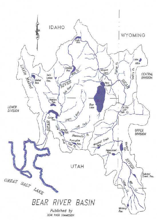
Figure 5
Bear River Basin
The original Compact apportioned direct flows of the Bear River and its tributaries between Utah and Wyoming in the Upper Division, and between Wyoming and Idaho in the Central Division. It defined original compact storage in the Upper and Central Divisions to each state as shown in Table 4.
Table 4
Original Compact Storage above Bear Lake
| State | Storage in Acre-Feet |
| Utah | 17,750 |
| Wyoming | 17,750 |
| Idaho | 1,000 |
| Total | 36,500 |
The amended Bear River Compact granted additional storage above Bear Lake, allocated as shown in Table 5. This additional storage, plus both surface and ground water appropriated and applied to beneficial use after January 1, 1976, is limited to an annual depletion of 28,000 acre-feet. The annual depletion is apportioned to the three states as follows: 13,000 acre-feet to Utah, 13,000 acre-feet to Wyoming, and 2,000 acre-feet to Idaho. In addition, the Upper and Central Divisions were allowed additional rights to store water spilled or bypassed from Bear Lake when all other direct flow and storage rights are satisfied. The storage rights were allocated as follows: 47 percent to Utah, 47 percent to Wyoming, and 6 percent to Idaho. The amended Bear River Compact also established a minimum Bear Lake level below which Bear Lake cannot be drawn for power purposes only.
Table 5
Additional Compact Storage above Bear Lake
| State | Storage in Acre-Feet |
| Utah | 35,000 |
| Wyoming | 35,000 |
| Idaho | 4,500 |
| Total | 74,500 |
The Bear River Compact is administered by the Bear River Compact Commission consisting of three representatives from each compact state and one federal representative. They are required to prepare biennial reports presenting the river operations under that compact. They are charged with overseeing the interstate river administration when flow is not adequate to satisfy demands within each state, known as a water emergency. Note that when water is plentiful, no interstate river administration is required.
If a water emergency exists, the responsibility falls on each state to curtail diversions and storage in the proportion dictated in the compact. When this occurs, states administer the river based on their water law. For example, when Wyoming must curtail diversions to meet compact requirements, the water division superintendent would "shut off" diversions to the lowest priority ditch first, then the second lowest, etc. until Wyoming is able to meet their compact requirements.
2.3 Bear River Basin Description
2.3.1 General Description
The Bear River headwaters are in the Uinta Mountains in Utah. It enters Wyoming flowing north through Evanston and into Woodruff Narrows Reservoir. Just downstream of Woodruff Narrows it flows into Utah and then re-enters Wyoming south of Cokeville. Its flow is increased greatly by Smith's Fork before it enters Idaho flowing west near the town of Border. As shown in Figure 5 above, the Bear River heads north through Idaho then loops back south, re-enters Utah, and discharges into the Great Salt Lake. In Wyoming, the basin is bordered by the Wyoming Range between the Bear River and the Green River basins. This range is generally less than 9,000 feet in elevation. Agriculture accounts for the largest water use in the basin. Surface and ground water are used to irrigate over 60,000 acres of crop land.
2.3.2 Climate
The average annual temperature in the agricultural area of the basin in Wyoming is near 40 degrees Fahrenheit and the average annual precipitation is around 11 inches. Greater amounts of precipitation, around 20 inches, fall generally as snow in the higher elevation mountains generating runoff to the Bear River and its tributaries. The agricultural regions of the basin in Wyoming are generally between 6,000 and 7,500 feet above sea level and the temperature allows the typical growing season to extend from mid-May through September. However, because of the arid climate, irrigation water is required to grow most crops.
2.3.3 Geology and Hydrogeology
The Bear River Basin is located in part of Wyoming's "Overthrust Belt". Overthrust geology is characterized by folded and faulted sedimentary rocks, which have eroded to form ridges and valleys. These faults and folds have a strong influence on ground water flow rates and direction. Several mountain ranges make up the Overthrust Belt and divide the Bear River Basin from the Green River Basin to the east and the Great Salt Lake Basin to the west. The State Engineer's Office Water Well Inventory database reports that 1,015 wells are located in the Bear River Basin.
An aquifer is a geologic unit that provides usable water to wells and springs. Most of the areas within the Bear River Basin overlay aquifers. The aquifer that consists of saturated alluvium within approximately 2 miles of the Bear River, generally referred to as an alluvial aquifer, is the most widely developed aquifer in the basin. Aquifers not within the alluvium are generally referred to as bedrock aquifers. Producing wells have been identified in at least 17 different bedrock formations in the Bear River Basin in Wyoming.
2.3.4 Upper Division in Wyoming
As discussed above, the Bear River Basin in Wyoming is divided by the compact into the Upper Division and the Central Division. Much of the information provided in this document is based on these divisions. Figure 6 shows the Upper and Central Division of the Bear River Basin and the outlines the Wyoming border.
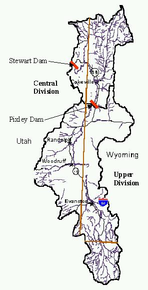
Figure 6
Upper and Central Division Boundaries
The main tributaries in the Upper Division include Mill Creek, Sulphur Creek, and Yellow Creek, however, in the Upper Division interstate regulation applies only to the main stem of the Bear River. Several storage reservoirs supply supplemental water for irrigation and municipal use in Wyoming including Whitney Reservoir, which is on the West Fork of the Bear River Basin in Utah; Sulphur Creek Reservoir; and Woodruff Narrows Reservoir, which releases water for use in both Wyoming and Utah. A relatively small amount of water is exported from the Green River Basin to the Bear River Basin through the Van Tassel Ditch to La Chappelle Creek then stored for downstream use in Ben Reservoir and Broadbent (Heber) Reservoir.
The Upper Division does not regularly fall under compact regulation, in part due to the supplemental water provided through storage. The amount of ground water used in the upper division is minimal, again reflecting the benefits of reservoir storage. Evanston once relied upon ground water to meet their municipal demand, but now primarily uses surface water from the Bear River and Sulphur Creek.
2.3.5 Central Division in Wyoming
The main tributary in the Central Division is Smith's Fork, which is administered as a compact tributary. Pine Creek is within the Smith's Fork drainage but has been defined in a court decree as not being tributary to Smith's Fork, yet still comes under compact regulation. Twin Creek also contributes to flow in the Bear River but is not regulated under the compact.
No significant storage exists in the Central Division. Partly due to this lack of storage, the Central Division goes into a water emergency, as defined by the compact, more frequently than the Upper Division. Twin Creek often falls under state regulation during the irrigation season, since the lowest headgate on the creek has the highest priority water right.
The Central Division uses ground water as a supplemental source for satisfying irrigation requirements. The town of Cokeville supplies their municipal demand with well and spring water from ground water sources.