| ||||||

| Home Page News & Information River Basin Plans Basin Advisory Groups Planning Products |
Executive Summary, Bear River Basin Water PlanBasin Planning Process Wyoming is undertaking pro-active statewide basin planning activities to represent changing conditions since the planning efforts in the late 1960s and early 1970's resulted in the publication of the Wyoming Framework Water Plan. The Framework Water Plan consisted of summaries of current water conditions and planning projections for six of the seven major river basins in Wyoming; the Bear River basin was not included in the Framework Plan. Due to technology constraints in the early 1970's, the data, mapping, and analyses tools used in developing the Framework Plan could not be easily updated to reflect changing conditions or new data. The 1996 legislature directed the Wyoming Water Development Commission (WWDC) and the State Engineer's Office (SEO) to prepare a recommendation for updating the 1973 Framework Water Plan. The recommendation concluded that the planning process should accomplish the following three main objectives:
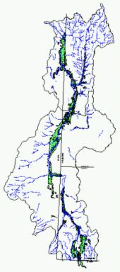
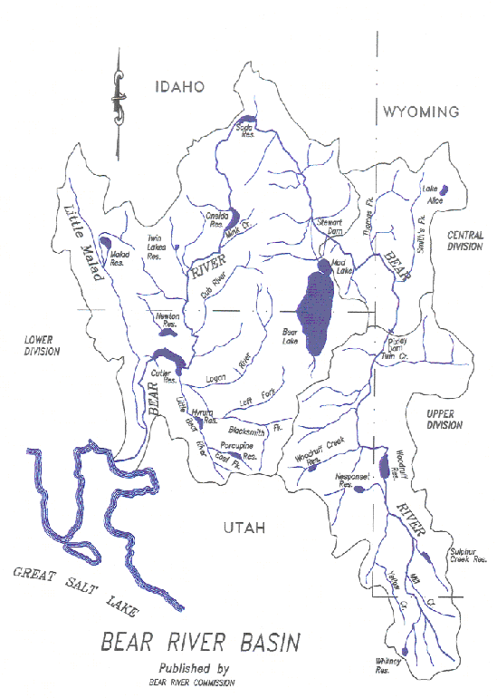
This Bear River Basin Water Plan Report, summarized in this document, is one of the results of the application of these objectives to the Bear River Basin. The Bear River Basin Water Plan and supporting documents, data, and models are available from the Wyoming State Water Plan Web Site (http://waterplan.state.wy.us/), or directly from the WWDC. Background The Bear River headwaters are in the Uinta Mountains in Utah. The Bear River enters Wyoming flowing north through Evanston and into Woodruff Narrows Reservoir. Just downstream of Woodruff Narrows it flows into Utah and then re-enters Wyoming south of Cokeville. The flow is increased greatly by the Smith's Fork River before it enters Idaho, flowing west near the town of Border. As shown in Figure 1, the Bear River then heads north through Idaho, loops back south, re-enters Utah, and discharges into the Great Salt Lake. The flow in the Bear River is allocated between Wyoming, Utah, and Idaho based on diversions and storage defined in the Bear River Compact. Agriculture accounts for the largest water use in the Wyoming portion of the basin. Surface and ground water are used to irrigate over 60,000 acres of crop land.
Figure 1 The Bear River Compact divides the Bear River Basin into three main divisions. Two of these divisions are partially within Wyoming. The Upper Division includes portions of Wyoming and Utah that are upstream of Pixley Dam, located in Wyoming south of the town of Cokeville. The Central Division includes portions of Wyoming and Idaho between Pixley Dam and Stewart Dam in Idaho. Much of the information provided in this document is organized by these divisions. Approach The Bear River Basin planning effort met the following four major objectives, which are each summarized in separate subsequent sections: The Basin Water Use Profile task determined and quantified the current surface and ground water uses within the basin (Section 3). Results Basin Water Use Profile The total basin water consumed in Wyoming due to human influence include the following categories:
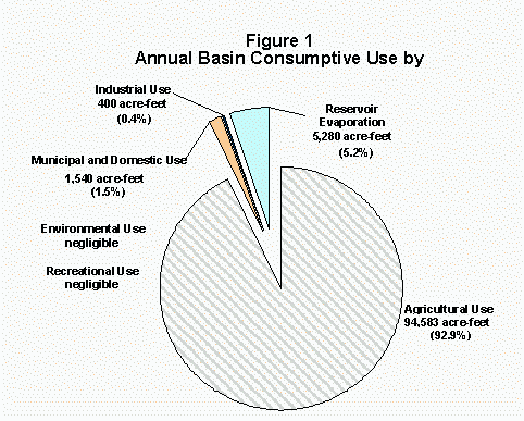
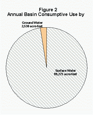
The current total basin consumptive use in Wyoming is approximately 102,000 acre-feet per year. Figure 1 shows the total basin consumptive use by type. It should be noted that although water is diverted to Cokeville Meadows National Wildlife Refuge (environmental use), it is used to irrigate crops historically grown in the area. Therefore, that consumptive use is included in the agricultural category. Water is used for recreational purposes in the basin both to maintain minimum reservoir pools and to maintain minimum streamflows. However, this use is non- consumptive.
Figure 2 shows the average annual basin consumptive use by supply source.
Basin Water Quality Profile Surface Water Total Dissolved Solids (TDS) is a measure of the total amount of dissolved salts in water. Although TDS does not provide the entire picture on water quality, it is easily measured and is, therefore, frequently used as an indicator of overall water quality. The following summarizes the surface water quality analysis for the Bear River Basin:
Ground Water Unlike continuous surface water quality gages, ground water quality measurements in the Bear River Basin have generally not been taken at the same location over time. Therefore, it is difficult to make assessments regarding trends in ground water quality. However, general conclusions can be made regarding the ground water quality of the aquifer that is tributary to the Bear River as follows:
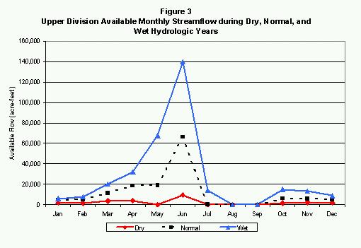
Available Water Determination Surface Water Surface water availability varies with hydrology and location in the basin. Spreadsheet Models were developed to represent historic dry, normal, and wet year hydrology in the basin. Current water use and Bear River Compact limitations were superimposed on the hydrology to estimate surface water availability in the basin. Figure 3 shows the total available monthly flow in the Upper Division for dry, normal, and wet hydrologic years.
The following summarizes the Upper Division available flows:
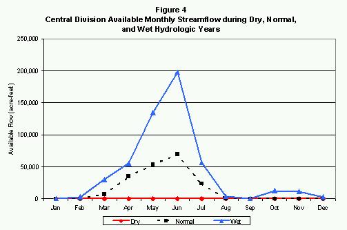
Figure 4 shows the total available monthly flow in the Central Division for dry, normal, and wet hydrologic years.
The following summarizes the Central Division available flows:
Ground Water Current ground water withdrawal estimates indicate that, on average, less than 3,000 acre-feet per year of ground water is currently used in the Bear River Basin. The majority of this use is from the Alluvial Aquifer, defined as the aquifer within the Bear River alluvium. Future development of this aquifer could provide additional water to meet increased demands, however there are limitations and restrictions to additional depletions outlined in the Bear River Compact. These restrictions consider withdrawals from the Alluvial Aquifer to be similar to river withdrawals. It is estimated that additional development of up to 14,000 acre-feet per year in the Bedrock Aquifers, defined as aquifers outside the Bear River alluvium, would be sustainable. Well development in the Bedrock Aquifers needs to be studied in greater detail to determine the impact on Bear River flows and the extent to which compact restrictions may apply. Demand Projections Demand projections were developed for two scenarios using an economic based approach. The planning horizon was 30 years, therefore growth was estimated through the year 2030. The High Case Scenario incorporates the most growth in key economic sectors that is reasonably likely to occur over the forecast horizon. This scenario incorporates the aggressive assumption that each of the key sectors will achieve its highest likely growth at the same time, providing an upper bound for water planning purposes. The Low Case Scenario incorporates the lowest growth reasonably likely to occur in key economic sectors. This provides the lower bound for planning purposes. High Case Scenario Total basin water diversion requirements are projected to increase by about seven percent from year 2000 to year 2030 under the High Case Scenario. Under normal hydrologic conditions, this amounts to about 21,400 acre-feet; under dry hydrologic year conditions the increase would be about 29,000 acre-feet. The following summarizes uses for the High Case Scenario:
Low Case Scenario Total water diversion requirements under the low economic forecasting scenario are projected to be slightly lower in 2030 than they were in 2000. The following summarizes uses for the Low Case Scenario:
Table 1
Future Water Use Opportunities Economic Development Opportunities Wyoming's approach to basin planning includes the identification and prioritization of future water use opportunities. This process involved extensive interviews with representatives from government, larger industrial entities, agriculture, energy, and tourism. These interviews and investigations did not result in the identification of any specific economic plans or opportunities beyond the growth scenarios presented herein. No listing of future opportunities, therefore, is included as part of this Bear River Basin Plan. As opportunity(s) are identified in the future, the spreadsheet modeling software created as part of the planning effort will we a valuable tool in ascertaining the feasibility and/or impacts of individual projects. Conservation Opportunities The state of Wyoming is supportive of water conservation as an environmentally responsible policy. In many cases, water conservation offers a direct economic benefit to water users. In the case of municipalities, for example, reduced water consumption translates into reduced treatment and operational costs. In the case of irrigation, one would expect agricultural users to benefit through increased overall water availability due to conservation measures. However, in the Bear River Basin, this is not necessarily the case. Current land application practices in the Upper Division almost exclusively involve flood irrigation. As a result of this practice, the Bear River is recharged, with up to 50% of the return flows re-entering the streams later in the irrigation season when divertible flows would normally be much less. This in-ground storage actually benefits water users late in the irrigation season. Irrigation conservation may be more economically attractive in the Central Division where Water Emergency conditions typically occur earlier in the season. Storage Opportunities Projected future water supply demands will require supplemental water from storage or from ground water, since there is essentially no available water for diversion during dry years. There were essentially 8 dry years in the 28 year historical study period. This represents approximately 3 out of every 10 years in which there are no additional divertible flows in excess of current water rights. There are virtually no available flows in either division during dry year periods, in any months. To guarantee a firm yield beyond existing allocations during these dry year periods, additional storage reservoirs would be required. Based on the normal year hydrology, the best development plan would be the construction of storage up to the yield available during these years - 150,000 and 190,000 acre-feet in either the Upper or Central Divisions respectively. There would be the need to carry over some storage to guard against dry year yields (zero) and to take into account losses from the reservoir(s). The firm yield, therefore, would be on the order of 75,000 acre-feet in the Upper Division and 95,000 acre-feet in the Central Division. The State of Wyoming has a remaining allocation of approximately 4318 acre-feet of compact storage rights under the original 1958 Bear River Compact. Additional storage development in excess of 4318 acre-feet would be subordinate to the requirement that storage cannot take place in the Upper or Central Division when the water surface elevation of Bear Lake drops below 5911 feet. There have been several previous studies directed toward the feasibility and capacity of various reservoir sites within the Bear River Basin. The potential for future reservoir construction was presented to the Basin Advisory Group (BAG) on several occasions for discussion. The consensus of the BAG was to not pursue or list storage as an option at this time. This feeling was, in part, due to economic concerns (cost vs. benefit) and environmental permitting concerns. None-the-less, storage is a viable option in the future as the need and/or economic desirability of storage changes. Near the completion of the planning study, water users from the Cokeville area approached the Wyoming Water Development Commission to initiate discussions relative to developing storage on the Smith's Fork. The Smith's Fork appears to have excellent storage potential from a hydrologic standpoint. There is a permit pending for the Ferney Glade Reservoir site on the Smith's Fork, which was filed in 1960 for 5201 acre-feet. A larger reservoir would likely require the partnership and participation of downstream states. Continued Planning Process Wyoming's Water Planning Process is not intended to provide a directive for the implementation of future water development, but rather to provide the basic information needed to address water issues that arise in the future. One of the most important products of the planning process is the collection, storage in a useable format, and understanding of basic water resource and water use data in the Bear River Basin. The Bear River Basin planning effort has created an informed group of citizens interested in water issues. The members of the basin advisory group have chosen to continue to meet three times a year to discuss water issues. The Bear River Basin Water Plan Report will provide the framework for discussions and planning efforts related to current water use, projected water use, compact issues, and other regulatory issues in the Basin. Previous Wyoming water planning documents provided useful snapshots in time, but were often outdated within a few years. The advance of computer and Internet technology will help assure that the Statewide Water Planning Process will remain current and accessible to the citizens of Wyoming. The WWDC intends to update each basin water plan approximately every five years. |
|||||