|
Home Page
News & Information
River Basin Plans
Basin Advisory Groups
Planning Products
|
U.S. Bureau of Reclamation Projects
Within Wyoming's Portion of the Colorado River Basin
Eden Project
Big Sandy Dam and Reservoir
General Description
The Eden Project furnishes an irrigation water supply for 17,010 acres. Project lands are in the vicinity of the towns of Farson and Eden in southwestern Wyoming about 40 miles north of Rock Springs. Project features are Big Sandy Dam and Reservoir, Eden Dam and Reservoir, Little Sandy Canal, Means Canal, Eden Canal, and a lateral and drainage system.
Plan
Unit Descriptions and Facilities
Big Sandy Dam was constructed to replace some storage in the existing off-stream Eden Reservoir and to supply water for additional project lands. The Means Canal conveys water from Big Sandy Reservoir to the Westside Lateral, which serves lands on the west side of Big Sandy Creek, and to the Eden Canal which serves lands east of the creek. Little Sandy Diversion Dam diverts water into the Little Sandy Canal which also supplies water to the Eden Canal. Water is
diverted from Big Sandy Dam to Eden Reservoir and from Little Sandy Canal into Eden Reservoir. Water is drawn from Eden Reservoir to serve Eden Canal and Farson Lateral.
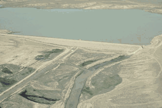
Big Sandy Dam and Reservoir
Big Sandy Dam is on Big Sandy Creek 10 miles north of Farson, Wyoming. It is a zoned earthfill dam 85 feet high, having a crest length of 2,350 feet and containing about 840,000 cubic yards of material. The uncontrolled open side-channel spillway has a capacity of 7,350 cubic feet per second.
The outlet works, consisting of a concrete conduit through the base of the dam controlled by two high-pressure slide gates, has a capacity of 620 cubic feet per second. An earthfill dike with a maximum height of 18 feet, 8,300 feet long, and containing 107,000 cubic yards of material lies north of the left abutment of the dam along the eastern rim of the reservoir basin.
Eden Dam and Reservoir
Eden Dam is a series of irregular dikes originally built under the Carey Act by Eden Irrigation and Land Company about 1907. In 1959, the Bureau of Reclamation constructed a new outlet works from the reservoir through the abutment in the southeast side of the reservoir to supply the old Eden Canal.
The reservoir is approximately 2.5 miles at its widest point, and 2 miles in length with a surface area of about 1,100 acres.The outlet works consists of a concrete lined tunnel controlled by constant head orifice gates and an overflow control structure. The spillway is contained in the outlet works as an uncontrolled concrete overflow structure above the orifice gates. The spillway
has a crest width of 15 feet and crest elevation of 6713.5 feet. A 22 inch wood beam has been added to the top of the spillway to get a new crest elevation of 6715.2 feet. The spillway is used only in an emergency since the water inflow to the reservoir is controlled by diversions through the Little Sandy Feeder Canal.
Canal and Drainage Systems
The three main canals on the project are the 4 mile long Little Sandy Canal, the 6 mile Means Canal, and the 10.8 mile Eden Canal. The diversion capacities of these canals are 150, 635, and 475 cubic feet per second, respectively. Irrigation water is distributed to project farms by the Westside, Farson, and Eden lateral systems. The laterals range in capacity from 6 to 160 cubic
feet per second and have an aggregate length of 94 miles.The 53 mile drainage system includes sub-surface drains averaging 10 feet in depth, and surface
drains about 2.5 feet deep.
Operating agencies
The Bureau of Reclamation operated and maintained the project during construction under contract with the Eden Valley Irrigation and Drainage District. In January 1970, operation and maintenance functions were transferred to the district.
Development
History
The route adopted by the first immigrant trains in 1842 on their journey to Oregon and California traversed an opening in the Wind River Mountains now known as South Pass. Emerging from this pass, the pioneer caravans traveled in a southwesterly direction for 25 miles to the Big Sandy drainage and the area now comprising the Eden Project. The project area is centered on the old
Oregon, Mormon, and Pony Express trails. Territorial records of 1886 show that permits were issued for settlers to divert water from Big Sandy Creek to lands within the present project area. The present irrigation development was initiated in 1907 under the Carey Act by the Eden Irrigation and Land Company.
This company created the Eden Reservoir by building dikes and an outlet works in an offstream basin to impound flows of the Big Sandy and Little Sandy Creeks. Although the company went into receivership in 1927, some land improvements were performed up to 1940.
Investigations
During the late 1930's, the Bureau of Reclamation and the Department of Agriculture investigated the project. The report of the investigations and recommended plan of development prompted authorization.
Authorization
A plan of development and rehabilitation was approved by the President on September 18, 1940, as a Great Plains project under the water conservation provision of the Interior Department Appropriation Act of 1940 (53 Stat. 685). Because of the long delay in construction caused by World War II, completion of the project was re-authorized by an act of the Congress on June 28, 1949 (Public Law 132, 81st Congress, 1st session).
Construction
Construction was started in July 1941. In December 1942, the construction phases were stopped by order of the War Production Board. The Department of Agriculture intermittently carried on land development during the years after 1941. The Bureau of Reclamation resumed construction activities on July 17, 1950, and, under the provisions of a 1949 act of the Congress, relieved the Department of Agriculture of responsibility for operation and maintenance and for collection of reimbursable construction costs. The act gave the Department of Agriculture authority to complete land development and settlement features of the general plan. Big Sandy Dam was completed in 1952. Final construction of the project, including rehabilitation work on the existing Eden Dam and Reservoir, was substantially completed by December 1959.
Benefits
Irrigation
Livestock production is the principal enterprise. Crops are alfalfa and grass hay, wheat, barley, oats, and pasture.
Recreation and Fish and Wildlife
Recreation facilities are administered by the Wyoming Recreation Commission, the chief activities being camping, boating, fishing, and picnicking. During 1980, annual visitation totaled 12,785.
Climatic Conditions
| Annual Precipitation: |
| Normal |
9.44 in |
| Maximum (1965) |
14.54 in |
| Minimum (1988) |
4.53 in |
| (Rock Springs, Wyoming 1961-1990) |
| Temperature: |
| Mean Annual |
42.7° F |
| Daily Maximum (6/23/54) |
96 ° F |
| Daily Minimum (1/12/63) |
-37 ° F |
| (Rock Springs, Wyoming 1948-1996) |
| Growing Season |
90 days |
| Elevation of irrigable area |
6,500 ft |
Project Data
Land Areas (1997)
| Irrigable area: |
| Full Irrigation Service |
17,010 acres |
| Supplemental Service |
0 acres |
| Temporary Irrigation Service |
0 acres |
| Number of Irrigated Farms |
75 |
| Residential, Commercial, Industrial Lands |
0 acres |
| Total Irrigable Lands |
17,010 acres |
| Population Served: |
| Farm Population Served |
231 |
| Non-Farm Population Served |
0 |
| Total Population Served |
231 |
Area Irrigated and Crop Value
| Year |
Actual Area Irrigated (Acres) |
Crop Value (Dollars) |
| 1988 |
14,438 |
1,626,336 |
| 1989 |
9,693 |
831,755 |
| 1990 |
10,454 |
1,111,174 |
| 1991 |
13,255 |
1,616,870 |
| 1992 |
14,499 |
1,747,018 |
| 1993 |
15,214 |
2,305,181 |
| 1994 |
15,743 |
3,404,543 |
| 1995 |
15,840 |
3,298,480 |
| 1996 |
15,919 |
3,515,353 |
| 1997 |
16,099 |
3,129,315 |
| Facilities in Operation |
| Storage Dams |
2 |
| Diversion Dams |
1 |
| Canals |
21 mi |
| Laterals |
94 mi |
| Drains |
53 mi |
Diversion Facilities
Little Sandy Diversion Dam |
| Type |
Earthfill |
| Location |
Little Sandy Creek, Wyoming |
| Year Completed |
1959 |
| Dimensions |
. |
| Structural Height |
10 ft |
| Crest Length |
600 ft |
| Crest Elevation |
6,745.0 ft |
| Diversion Works |
One 12 ft by 7 ft radial gate, bottom elevation 6,733.7 ft. |
| Diversion capacity |
150 cfs |
Carriage Facilities
Eden Canal |
| Type |
Earth-lined, trapezoidal canal |
| Location |
From Eden Reservoir generally south |
| Construction period |
10.8 miles of Eden Canal below junction with Means
Canal enlarged and relocated in 1952-1955 |
| Length |
10.8 mi |
| Diversion capacity |
475 cfs |
| Means Canal |
| Type |
Earth-lined, trapezoidal canal |
| Location |
From Big Sandy Dam generally south to Eden Canal |
| Construction period |
1952 |
| Length |
6 mi |
| Diversion capacity |
635 cfs |
| Little Sandy Canal |
| Type |
Earth-lined, trapezoidal canal |
| Location |
From Little Sandy Diversion Dam generally west to
Eden Canal below Eden Reservoir |
| Construction period |
Consists of 2.2 miles of existing canal rehabilitated and
1.1 miles of new canal completed in 1957. |
| Length |
4 mi |
| Diversion capacity |
150 cfs |
|
